Links

Sunday, August 23, 2009

Public transport to Melbourne's fringes

Public transport in Melbourne's fringe is an interesting blend of urban and rural practice, as regards mode, operator, method of traction, service levels and absence or presence of route numbering. Historical factors regarding the choice of mode, and later decisions regarding service improvement, largely determine the type of and level of service offered.

The following lists the types of services provided to fringe areas.

a. Suburban (electric) trains, currently operated by Connex.
b. Inter-urban (diesel) trains, operated by V/Line (Stony Point excepted).
c. Regional coaches (has a country destination and no suburban route number)
d. Suburban buses (MOTC minimum standard)
e. Suburban buses (limited days/hours)
f. Suburban buses (occasional service)

The above is a classification based on a mix of mode, traction method and service level. However if service level only is considered, they can be placed into two groups; 'high service' or 'low service'. High service routes run 7 days a week from morning to at least mid-evening (9pm). Service frequency is 60-90 minutes or better. 'Low service' routes run only 5 or 6 days per week and/or have restricted spans and service frequency.

The areas themselves are equally diverse. They can be established seperate cities in the line of Melbourne suburban encroachment, a string of settlements on a scenic highway towards the hills or coast or a subdivision that was empty fields until a few years ago. I have classified these as follows, noting that some areas fall under more than one group:

A. Regional cities. Self-contained centres established in the 1800s with their own suburbs, local government and local bus networks. Do not always regard themselves as being part of metroplitan Melbourne, although some of their residents commute to metropolitan area jobs. Most housing is at suburban-type densities. Examples: Sunbury, Rosebud, Mornington, Healesville.
B. Regional hamlets and villages. Long established settlements smaller than the above but with a distinctive rural or coastal flavour. Vary in size but comprise at least a general store, a primary school surrounded by a few streets of housing at suburban densities. Examples: Cockatoo, Emerald.
C. New outer suburb. Melbourne frontier areas that have been subdivided into suburban-sized lots for new housing. May be stand-alone development with no established centre (eg Doreen or Point Cook) or be an accretion to an existing long-established centre (eg Werribee, Mornington, Berwick or Hastings).
D. Semi-rural. Residents live on acreages (eg hobby farms) and often commute for work in Melbourne or the nearest large regional centre.
E. Rural. Predomiantly agricultural land uses with low housing densities. Residents work locally, often on their land or in the nearest town.

The remainder of this item will group into discuss the transport available at a selection of fringe locations, grouped by service levels available. Capital letters after each name describe the area while small letters describe the transport type (note the area descriptions are rough approximations only).

Relatively high service areas

Doreen (Cd): Leap-frog sprawl has been upgraded from 'limited service' to 'minimum standards' service in last few months.
Gembrook (Bd): Local route (695) has been upgraded to minimum standards.
Hastings (ACbd): Hastings has had its train removed and then reinstated. It is also served by buses that roughly follow the line and are more frequent (but slower) than the train.
Healesville (Ad): Like Mornington Healesville lost its train and has suburban-numbered buses provided as substitutes.
Hurstbridge (Ba): This is the least urbanised fringe area to retain a suburban train service. A suburban span at half standard frequency applies. Despite its distance from the CBD it remained in the 'middle suburban' Zone 2 when the three-zone fare system was in force.
Lara (Bbe): Effectively an outer suburb of Geelong, Lara is served by an extension of that city's bus system as well as regional trains.
Melton (ACbe): Served by regional trains and local buses.
Mornington (ACd): Previously served by infrequent trains, Mornington has had these replaced by buses in 1981. Frequency and span upgrades to these services give central Mornington the most frequent service (20 minutes) of any fringe area in Melbourne.
Pakenham (ACad): The longest Melbourne suburban line (although electrification prevously extended to Traralgon). Served by (approximately) every second daytime Dandenong line train and has recently had a boost to evening train services and local bus services.
Portsea (Bd): Has long had a seven-day service but service span and frequency has been improved since Route 788 was upgraded to 'minimum standards'. Parts remote from 788 receive a limited service from Route 787.
Rosebud (Ad): Has long had a seven-day service but service span and frequency has been improved since Route 788 was upgraded to 'minimum standards'. Parts remote from 788 receive a limited service from Route 787.
Sunbury (ACbd): Served by regional trains and local buses. Electrification plans announced but not all locals are happy.
Warburton (Bd): This area was previously rail-served but has had the service replaced by coach-style buses displaying a suburban route number (683).
Warrandyte (Bd): Served by a variety of metropolitan bus routes, some to 'minimum standards'.
Whittlesea (BCd): Served by minimum standards route.
Yan Yean (Dd): A semi-rural area passed over by the urban frontier, which is now further north at Doreen. Upgraded to 'minimum standards' service in last few months. Yarra Junction (Bd): This area was previously rail-served but has had the service replaced by coach-style buses displaying a suburban route number (683).
Yarrambat (BDd): Semi-rural area passed over by the urban frontier, which is now further north at Doreen. Served by two 'minimum standards' routes.

Relatively low service areas

Belgrave Heights (De): Route 697 limited service.
Clyde (Bcf): Receives service from a mix of suburban and regional routes.
Flinders (BF): Occasional service.
Humevale (BDe): Occasional service.
Kinglake (BDf): Once-daily service.
Koo-Wee-Rup (Bc): Served by country coaches only. However these have recently been upgraded and offer services that connect to a wide range of destinations during the day.
Manor Lakes (Ce): An outer part of Wyndham Vale. Fast-growing new housing area. Suburban housing densities.

Melbourne Airport (e): Limited service on regular services.
Pearcedale (BDf): A small settlement between Frankston and Cranbourne. Low density of housing.
Point Cook (Ce): A large area of new suburbia. Served by metropolitan buses (413, 416) operating at suburban-type frequencies but with limited days/hours.

Red Hill (BD): No service.
St Andrews (BD): No service.
Tarneit (Ce): A large area of new suburbia. Served by metropolitan buses operating at suburban-type frequencies but with limited days/hours.

Warneet (Bf): A small coastal settlement. Limited services (route 795) operate from Cranbourne.
Werribee South (BEe): A small coastal settlement remote from Werribee proper. Bus route (439) also served market garden area.
Wonga Park (De): Semi-rural acreages. Limited service.
Yarra Glen (BDf): Occasional service.

Conclusions

What are some patterns in the above list?

The first is that some relatively rural areas more than 50 km from Melbourne have quite high levels of service. Often these are ex-rail areas like Healesville, Yarra Junction and Mornington where the substitute coach provided runs more frequently than the train ever did. The 2006 regional rail timetable upgrades and the Meeting Our Transport Challenges 'minimum standards' program (for metropolitan buses) both boosted spans and frequencies in many of the better served areas listed above.

While I have not done any interstate comparisons, Melbourne appears to compare well with other cities like Perth that have very little urban fringe transport (Pinjarra, Serpentine, the Swan Valley and Mundaring for instance have limited or no service, and the twice-daily 'Australind' to Bunbury compares poorly with any of our RFR lines).

Some of the low service areas aren't very populated, so are unlikely to be a high priority for service improvements. However some might merit occasional services of the type provided under the 'Transport Connections Program' to rural areas.

Then there are the low service areas that already have high (and fast-growing) populations at suburban densities. Suburbs like Point Cook, Tarneit and Manor Lakes made it into the low service list as they are awaiting minimum standards upgrades, having been passed over in favour of other areas in the initial rounds. All of the latter (plus other low-service areas, eg around St Albans, Endeavour Hills, Frankston, Narre Warren and even Kensington Banks) are currently the subject of bus service reviews and may see improvement if likely review recommendations are implemented.

Monday, August 17, 2009

Cheap fares in Australian capitals

A good post from Lifehacker compares discount public transport ticketing options between Australian cities.

And for those flying there's also a post on cheap airport to city transfers.

Tuesday, August 11, 2009

The well-versed train driver

A driver announcement made on this morning's 0720 ex-Frankston train to explain a delay between Glenhuntly and Caulfield:

Ladies and gentlemen

The signal is against me

We’re waiting for a down train

Before we can proceed

(verbatim except for one word)

Sunday, August 09, 2009

Walking a fine line: A look at Victoria Walks

You may have noticed a new link added to the sidebar - Victoria Walks.

While I've previously posted on pedestrian issues, the emphasis has been on walking to access public transport and transfer between services.

However walking also needs to be regarded as a transport mode in its own right, and not just as a means of recreation or physical exercise. Walking even beats public transport for some trips. The distance where walking is faster ranges from about 1 to 5 kilometres, with higher figures in pedestrian-hostile locations, or where where transit has limited frequency, connectivity, directness and coverage.

How significant is walking as transport? The census question about transport asks about the journey to work. This is the very journey that people are least likely to walk and walking's modal share is low. Counting all trips would probably give a higher share for walking but it is still often dismissed as a 'minor access mode'.

What are the main threats to walking's attractiveness as transport? Key is bad urban and traffic system design, with examples being missing footpaths, absence of crossing facilities, buildings that don't address the street or have easy footpath access, long traffic light cycles or excessive use of roundabouts, blank walls facing footpaths and poor passive surveillance. The design of our suburbs, covering matters such as a permeable street grid, location of transit stops, and co-siting of activity centres around transport nodes are also important. The costs of designing new suburbs along these lines is negligible, and even retrofitting existing suburbs need not be expensive given the benefits. There are also social attitudes, for instance a perception of being unsafe when walking. Just as with public transport safety more people walking tends to create a virtuous spiral of 'safety in numbers'.

What is walking's political representation like? Drivers have the RACV. Cyclists have Bicycle Victoria. Public transport passengers have the PTUA. Even though there are more pedestrians than either drivers and public transport passengers, Victorian pedestrians have no organised lobby to advance their interests (whereas NSW has the Pedestrian Council).

As walking costs the user nothing, there is almost no 'walking industry' or 'vested interests'. For example, it requires no ailing car industry for governments to protect with tariffs, subsidies or loan guarantees. It involves no new trains, trams or buses. Plus there are no multimillion dollar franchises, operator contracts or powerful unions at stake. The upgrade of suburban streets to become walkable grids would generate jobs for road construction companies, but these firms could just as easily be building new roads, so these companies don't have a particular vested interest in pedestrian improvement projects either.

Does the lack of political representation for a particular transport mode automatically mean that nothing in that field gets done? Not necessarily. Though Perth's 'Friends of the Railways' were successful in getting the Fremantle line restored, and this fostered the biggest suburban rail revival of any Australian capital, it appears to have been academics and sympathetic governments who maintained the momemtum to complete a series of major projects including electrification, Joondalup, Thornlie and Mandurah. WA appears not to have a passenger lobby group as prominent as the PTUA in Melbourne (and those that are there appear to have been offshoots from a reasonaly strong environment movement, eg STCWA) who would have been expected to advocate such extensions.

The situation as regards walking in Melbourne is a little different. As mentioned above there is no prominent pedestrian lobby. University transport academics occupy high profiles in public debate but public transport and urban planning tend to be their favourite topics. Other matters such as walking and freight transport appears to be less advocated, or at least are less reported in the papers.

Is suburban walkability a significant part of state transport plans and budgets? When considering this allowance needs to be given for the involvement of both local and state governments. The various state transport plans have typically involved road and public transport infrastructure projects, with a swing towards the latter in the Victorian Transport Plan. Pedestrian access was not a major part of this plan, or of the debate that preceded it (about the Eddington report, tunnels and surging rail patronage). While there exists a Local Area Access Program that supports pedestrian access projects, its budget appears to reflect the extent to which walking is regarded as a serious transport mode.

The lack of a lobby and academics to lead debate, the relative absence of media on pedestrian access topics (outside the occasional article in the local paper) and the absence of a significant program to make existing suburbs walkable all indicate unmet needs. These only intensify when the social and fitness benefits of walking are added.

Stepping into this gap is the Victoria Walks website. This turns out to be a registered charity sponsored by VicHealth. VicHealth is a health promotion foundation established by parliament as part of the Tobacco Control Act (1987). Although funded by cigarette taxes, its health promotion goes well beyond the Quit Campaign to includes areas such as physical activity, which is where Walking School Buses and Victoria Walks come in.

To reflect its sponsor's aims, the motivation behind Victoria Walks appears to be the health benefits of walking. This is much like how cycling and cycle tracks is seen as a recreation as much as a transport mode. And some might see buses in some areas mainly as social welfare, since their ridership is predominantly 'captive passengers'. Which leaves cars, trucks and trains as the 'serious' transport modes deserving of 'real dollars' through various transport plans and administered by a dedicated department.

What is the content of Victoria Walks? There is one thing it isn't; it's not a simple exhortation for everyone to walk at least 30 minutes a day.

Instead it emphasises a 'bigger picture' or 'community engagement' model. If psychology can be said to emphasise the individual's mind and sociology society's values, Victoria Walks is clearly favours the social, the community and the 'active' (politically as much as physically).

Hence site readers are encouraged to do 'walking audits' of their neighbourhood and form 'walking action groups' to 'engage government'. There are many case studies from parts of Melbourne and around the world to open minds as to what can be done. And the achievements of Walking Action Groups, such as questions in parliament and replies from councils, are highlighted for further encouragement.

Although its excellent website contains much useful background information, Victoria Walks is not a lobby group in itself. After all its funding source effectively makes it an arm of government, and one area trying to lobby another part would look odd. Nevertheless it does engage in what I would term 'advocacy support'. They won't directly lobby or give specific advice but the website acts as an enabler, encourager and mouthpiece for others to do so.

Victoria Walks is an example of initiative on an aspect of transport coming from outside the department ostensibly responsible for it. The progress of it, and particularly any activity it spawns, will be well worth watching.

Thursday, August 06, 2009

What's in a route name? (Part 3)

While a particular description may work for an individual route, there are times when the route forms part of a 'family' of related routes. These are often scheduled together and provide a regular and frequent service along a particular corridor. In other cases routes may have little overlap yet have similar origins and destinations. Especially when one of the destinations is a major centre, it is desirable to highlight that passenges can use either route to make the trip.

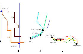
The diagrams below show various types of related routes.

Example 1 are two routes with little in common apart from their common origins and destinations. (To split hairs one route actually continues further but is not relevant to this discussion.) There are no major trip generators along the route and Coburg, at the end of both, is the most important destination in the area shown.

As well as serving local travel needs, a benefit of these two routes existing is to provide a higher service frequency between Glenroy and Coburg. Information at both ends should highlight the fact that there is more than one direct service from Glenroy to Coburg.

Attention to this can be drawn by several measures, including station signage, the same or adjacent bus bays at interchanges and well-written route descriptions (preferably displayed above and below one another). At Coburg 513 could be described as 'Coburg to Glenroy via Pascoe Vale' and 534 as 'Coburg to Glenroy via Merlynston'. Alternatively, sequential ordering, eg 'Coburg > Pascoe Vale > Glenroy' and 'Coburg > Merlynston > Glenroy' would also be effective. In both cases use has been made of one intermediate point to highlight the differences for passengers only near one of the routes.

The second example is a suburb - CBD or freeway radial pattern. Unlike the first example origins are different but the routes come together closer to the city, overlapping to provide a more frequent service along the common portion. The dominant flow is peak direction trips, and for this purpose the main passenger information need would be a combined timetable (possibly printed as a seperate item) listing all services between the best served stops. Niche opportunities include 'reverse commuting' and after work trips via a shopping centre and then returning to a park & ride. However compared to the previous and next examples route via information is perhaps less important.

Most interesting is Example 3 above. This shows a family of routes that serve several major trip generators along the common portion between Chadstone and Monash. The routes then fan out to residential suburbs before combining again to serve another major trip generator at Dandenong. These routes have been scheduled as a group and provide a combined 15 minute service on weekdays.

Good route descriptions are an effective but under-appreciated method of simplifying the bus network and highlighting the corridors of frequent service in areas of real patronage potential. Instances of their use is given by two examples: a route map for Route 600/922/923 and an hypothetical totem-style sign at Chadstone Shopping Centre, both shown below.

Major destinations for each route are displayed sequentially for what I consider is a neater and more legible result. The large number of intermediate destinations and the desire to keep all descriptions on the one line has created a trade-off regarding print size. However keeping to one line per route highlights the 'stacking' advantage for related routes. Because route descriptions are immediately above and below one another it is easy for the viewer to identify the similarities between the four routes shown, provided that care has been taken in their writing (one route should not have Oakleigh omitted if it like all the others goes there) and their layout.

While the number of 'via' destinations may seem high, in this case all are quite substantial interchanges or destinations so deserve mention. Plus it and the service frequency offered (claimed 15 minutes, but it's as high as 7 buses per hour to some destinations) may cause some people not to bother with the timetable. In case there was any doubt, an extra note has been added advertising all routes' potential as feeders to trains and other buses at Oakleigh. As with the Coburg example one destination per route was reserved for where it was differs to the rest.

What would the 'intermediate stop' description at the Dandenong interchange end look like? It could be the same as the above but in reverse order. Or maybe not, with the space used for more local destinations instead. After all, from Dandenong Station there are better ways to get to Oakleigh Station than by a bus that is less direct than the train. On the other hand some passengers may wish to avoid transfers and those travelling from as far as Dandenong North might still prefer the direct bus option to go to Oakleigh (especially given the similar combined frequency on weekdays). This again underlies the point made earlier that space is finite and trade-offs may have to be made.

To conclude, the use of intermediate descriptions for routes has potential to make bus travel simpler and easier for passengers, whether it be on maps, bus destination displays, websites, timetables or signs. When used with related routes it can help to highlight network features such as frequent service corridors. This assists marketing by helping passenger develop a stronger 'mental map' of the bus network and its potential usefulness for more of their trips.

Sunday, August 02, 2009

What's in a route name? (Part 2)

Part 1 listed the most common ways to identify bus and tram routes. In major cities all routes generally have a route number. In addition they have a word description, such as a street served, destination suburb or major landmark.

Different descriptions suit different routes. Three examples are given below.

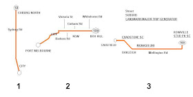
Route 19 is a major north-south tram route in Melbourne. It is largely confined to Sydney Road which is a near-continuous ribbon of retail and commercial development. Trams come every vew minutes and the service is heavily used for both short and longer distance trips. The northern terminus at Coburg North attracts little patronage and contains no significant trip generators except for a school. While Coburg and Brunswick are major suburbs along Route 19 the route is characterised by a large number of small trip generators rather than a few large trip generators. Hence the 'Sydney Road tram' is probably the most apt description for this service. If you had more space, then a description like 'Coburg North via Sydney Road', 'Sydney Rd > Coburg North' or 'City - Sydney Rd - Coburg North' are all acceptable.

What a difference a zero makes. Route 109 is a major east-west tram route. It is fairly direct but the streets it runs along sometimes change name. Since it was extended to Box Hill the route's terminus is a major transport node and trip generator. Port Melbourne also generates trips, being near apartments, restaurants and the ferry terminal. Main intermediate trip generators include Victoria Street/Victoria Gardens and the Southbank/casino precinct. Most coming from Port Melbourne would be travelling towards the city rather than to Box Hill and vice versa. All this adds up to a route description that is more suited to including the terminus suburbs and CBD rather than streets. Workable choices include 'Box Hill via City' or 'Port Melbourne - City - Box Hill'. Street information has some use (especially in inner city areas) but could be provided on maps only.

The third example is bus route 900, or the Wellington Road SmartBus. Much of 900's popularity is between the major and closely spaced nodes of Caulfield, Chadstone, Oakleigh and Monash University (Clayton) even though Wellington Road is the route's longest portion. Chadstone, Monash University and, to a lesser extent, Stud Park, are 'special purpose nodes' with poor pedestrian access to the surrounding area. Hence these stops serve a particular trip generator or allow interchange to other bus routes but don't greatly add coverage to a suburb (based on number of homes within a 10 min walk). For this reason Monash Uni (Clayton) may be a better description of the route's service area than Clayton North. And note that Rowville isn't universally used either.

Route 900 is harder to simply describe than either of the above two tram routes. Calling it the Wellington Rd service ignores key stops so the best answer is likely to be a combination of suburb and trip generator given the importance of at least two of the latter. Emphasising trip generators can also exploit patronage promotion opportunities, eg encouraging lunchtime travel from Monash University (either campus) to Chadstone Shopping Centre. If there is enough room, descriptions like the following may be suitable: 'Caulfield > Chadstone SC > Oakleigh > Huntingdale > Monash Uni > Wellington Rd > Rowville'. This is probably too long, but removing any would de-emphasise a major trip generator (eg Monash Uni or Chadstone) or a train connection (eg Huntingdale, where 900 & 630 provide a frequent shuttle to Monash).

Another decision to be made when describing a route is syntax and punctuation. Descriptions may appear on anything from printed timetables, websites, bus destination displays (which could be static or scrolling), stop information, maps or a mobile phone display. Sometimes space may be strictly limited (eg signage) but elswhere more may be available. There is a trade-off between standardisation and customisation, and a fine line between desirable information and clutter.

The following timetables from various cities show different description formats used.

One thing noticed is the use of words like 'via' and punctuation such as '>'. The same route can be described in several ways, for example:

1. Port Melbourne - Box Hill via City
2. Port Melbourne > City > Box Hill
3. Port Melbourne - City - Box Hill

The first example emphasises the ultimate destination of the service, with the via almost as an afterthought. This has some sense, especially if the front of the tram is displaying 'Box Hill'. However because this is a through-routed route most passengers are probably more interested in the city than Box Hill. Another problem of 'via' descriptions is mental 'jerkiness'. In other words one pictures Port Melbourne and then Box Hill. But when we read 'via City' one is mentally forced back along the route to an intermediate point.

For this reason, I'm a big fan of the second ('progressive' or 'sequential') format, where the reading across effortlessly replicates the order of stops and provide a strong visual cue of the direction of travel (people know which way the city is, but they might not know Box Hill's direction). This is especially valuable at stop signage as it reassures passengers that they are waiting in the correct side of the road for buses going their way. Such a linear progression is good for scrolling bus destinations, which unlike a printed page relies on persistence of memory so has stricter requirements. It is also legible for longer descriptions involving various landmarks (such as the 900 example above) and has benefits for multiple routes that serve a common corridor (more in Part 3). On large signs 'progressive' syntax gives a fresh, clean look as it removes the need for non-content words like 'and' or 'via' as well as commas.

3 above is similar to 2 except for dashes instead of arrows which are used to lower the illustration of directionality. This is is good if the route runs in both directions but you are not specifically referring to either direction. Examples may include brief route descriptions on maps (such as some of the above pictured), indexes in local area maps and on the covers of printed timetables. Tracing a route against an arrow is counter-intuitive, so where this is permissible (eg when reading maps) we could use the gentler dashes (instead of arrows) to not block this style of reading.

A minor consideration (mainly desired for consistency and ease of use within the industry) is the order of locations in a route description. For instance, should a route be described as '844: Dandenong - Doveton' or '844: Doveton - Dandenong'? If we see the network as comprising a rail 'spine' with bus feeders then the former 'in-out' order may be useful since one can easily sort timetables according to the station they feed off. Also routes tend to be closer together the nearer they are to the CBD and may sometimes form a well-served common portion, as we see with 802/804/862. In this case a description of Chadstone - Oakleigh - Monash Uni - Dandenong has the common sections first, which provides a small amount of emphasis. The alternative starts where people live, and what they are more likely to ask for - ie 'a timetable for Doveton'. Overall this is the least important aspect covered but ideally consistency should be aimed for, especially between related routes.

How long should these sort of route descriptions be? The space limitations of various media has already been discussed. But if space is sufficient my answer is that they can be quite long. Five or six intermediate destinations might not be excessive provided they are all important (again as with the 900 example). Even if readers skip over reading some of the intermediate locations they will probably see the first and last place name. If the description is linear sequential (ie no via text) then the last place will be the route's terminus, which will sometimes be all they wanted to know anyway.

When people get to a particular bus stop they want to know where the bus is going, not where it has been. This has potential to simplify the information provided without reducing detail. In other cases the same amount of information could be provided but made more relevant for the customer. As an example, a city stop towards Box Hill might describe Route 109 as being to 'Victoria St > Kew > Box Hill', which would be more useful than 'Port Melbourne > City > Box Hill'. There is however a cost and effort trade-off between higher-quality area-specific information and a more general 'one size fits all'.

Part 3 will end this series, with a look at route descriptions for corridors served by multiple routes.

Saturday, August 01, 2009

What's in a route name? (Part 1)

People use several ways to describe a bus or tram route. Descriptions can relate to an area served, destination suburb, major road or significant trip generator. Route numbers, though used in major cities, tend not to be displayed for regional coach or country town services.

Governments may wish to give special names to new services, for instance 'Knox Transit Link' or 'Manningham Mover'. Colloquially, certain routes might be known by the colour of the bus (eg 'the brown bus') or the name of the operator. Then there were some that had a 'nameless name', such as Route 787, which was formerly known as 'The Bus'.

The history of route descriptions is intertwined with changes within the bus industry and suburban expansion. Recent developments such as Metlink, unified signage and timetables, website timetables, and real-time information delivered by mobile phone promise further changes. These will be discussed in the next few paragraphs.

The pioneers of the bus industry in the first few decades of the twentieth century were often small owner-operators running a few short routes each. Suburbanisation in between the tram lines, the spread of the internal combustion engine and a large number of households without their own cars would have all contributed to growth. Fare revenue covered costs without government subsidy, although legislation was introduced in the 1930s to prevent bus operators from competing with government tramways.

The early 1970s saw a reorganisation of bus route numbers and government subsidies after declining patronage made their operation unprofitable. The 1980s brought fare integration and, later, some standardisation of passenger information. Routes were often amalgamated and/or extended into new areas, so became less 'local'. After a period of service cuts and fragmentation in the 1990s information integration returned in the 2000s through Metlink's website, journey planner and printed timetables. Connectivity and timetable integration with other services varies but improvements are promised after the current local area bus reviews.

The structure of the bus industry has changed radically in the last 40 years. State funding did not come without strings. The modern bus operator has had to become more professional with extra tasks including the need to account to government for subsidy, uphold modern maintenance and workplace standards, provide 'service change' information to Metlink, administer Metcard ticketing, and participate in bus service reviews. Just ahead is the spread of real-time information and Myki smartcard ticketing. Larger operators are steadily buying out the smaller operators with at least three takeovers so far this year. Route 509 along Hope Street, Brunswick remains today's only fragment of a previous era of shorter routes and 'one-man' operators.

While buses are still mostly for local trips (rather than CBD or corridor travel, as is the case with train and tram) their localism has diminished. This can be partially attributed to the operator and route amalgamations mentioned previously and 'super-routes' like 903. Better publicity of services (chiefly through the online journey planner), longer service spans (hence more drivers), a more transient population and (in some companies) the larger number of routes that a driver may be rostered on, further reduces the chance of drivers knowing their passengers (limited service routes like 606 may be exceptions).

The above trends have changed the way that routes ought to be described as the potential user base is more widely spread than in previous times. The 'Hope Street Bus' may be pefectly understood by Brunswick locals, but doesn't cut it in a metropolitan area with about 10 other Hope Streets. There are many K-mart stores, but the big ones known by locals are in Campbellfield and East Burwood. Conversely there are many 'Sydney Roads', but most would know that there's only one really big one with trams every few minutes. Is Tram Route 19 best described as to 'Coburg North' or via 'Sydney Road' or both? Similarly Tram Route 78 serves Chapel St, but has a destination of Prahran, which is its main service area, though it actually terminates near enough to either Balaclava or St Kilda East.

Route destination and via information needs to convey meaning for both locals and visitors. If well-used they can be a succinct way of providing service information. They enable passengers to form a sensible 'mental map' of the network and can highlight cases where frequent service is provided by identifying the common sections of routes or 'route families'.

Even route numbers can convey similar information if wisely chosen. The division of the frequent route 600 into the related (but slightly different) routes 600, 922, 923 was probably a mistake overall, although it did extend Sunday service to some areas. If it was done at all the allocation of 601 and 602 instead would have assisted legibility. It is worth mentioning that choosing 922 was not without merit since it replaced the former 822 in the area. However this short-term gain reduced long-term legibility so it was a poor choice in hindsight. Similarly the related 802, 804 and 862 would be more legible if 862 was renumbered 803 (803 was briefly a trial night/weekend service but could safely be reused now).

The aim of this part has been to illustrate the various ways that bus and tram services have been described. Attention has also been paid to some of the changes that have reduced localism. Reduced localism requires that services need to be made legible for a wider passenger base. Route descriptions are a key aid to this, with further details to be provided in Part 2.