Big two or more lane roundabouts are a road engineer's fetish that have no business being near where people walk. Unlike lights with a walk phase they offer no certainty for the walker who needs to cross. Also they encourage drivers to look right for cars and not left for people walking or cycling so may pose a safety risk (even though some smaller roundabouts beyond scope of this item have zebra crossings on their approaches).
Large roundabouts also encourage continuous, fast-moving traffic without gaps. This is bad for people crossing both at intersections and midblock. At best there may be 'beg button' pedestrian signals on one or more of those legs but they are often away from walking desire lines. And they don't fully help if you need to cross multiple entry points, not all of which are signalised.

Vicroads, which is extremely good at building roads and moving cars, tells walkers they are neither catered for nor welcome at many of its roundabouts. Their pedestrian safety page includes a section on crossing the road. There is a dedicated 'fact sheet' on crossing at roundabouts. That's gloomy news for walkers, including mention that they have no rights at roundabouts.
A separate section deals with multi-lane roundabouts, with mention that it can be hard to cross due to fast and continuous traffic. Often so called 'safer places' to cross simply don't exist for hundreds of metres or more.
At roundabouts all onus is put on the walker to be safe rather than the controllers of two (or more) tonne vehicles that kill about 40 Victorians walking each year. According to the fact sheet, pedestrians may not know the rules and can make mistakes. However there is no mention of car drivers making mistakes, probably because roundabout rules are so stacked in their favour that they can do no wrong (unlike the walker who needs to time their dart across carefully after an indefinite wait). Vicroads' take home message to walkers at roundabouts? Go away. Take a different route. Drive, don't walk. Adding to traffic might even strengthen our business case for more or wider roads (that discourage walking even more). If you don't drive then just stay home as we don't think your trip is important.

The human scale, which a lot of traffic engineers don't get, is critical. Asking a walker at 4 km/h to deviate 500 metres is like asking a car driver at 80km/h to deviate 10 kilometres. Vicroads would never dream of asking that of drivers, especially for local trips. And if they did few would comply. But walking trips are somehow unimportant and expendable in Vicroads' 'move more cars' ideology that is spoken so loudly through its infrastructure that it drowns out later messages about sustainability and active transport.
There do exist good or at least tolerable roundabouts. Very small single lane types can work for traffic calming in local streets. Provided that their design keeps walkers on straight lines they are OK. We might be able to learn from the Dutch. Here's a type of roundabout
in South Melbourne that's won praise. But examples like the latter are rare. When it comes to multi-lane roundabouts on busy roads it's easier to 'just say no' and advocate intersection signalisation (with short cycle times for efficient pedestrian access and no slip lanes for enhanced safety).
Drawing inspiration from level crossing removals
The Andrews government has had its political ups and downs. But one thing that has held up its political stocks is the railway level crossing removal program. A large number of removals meant that most people were near or at least occasionally travelled through at least one (and often several) of the included projects.
Although motorists are the program's main beneficiaries there were also gains for bus users, cyclists and pedestrians at some sites. Along with train passengers where stations got rebuilt. And while derided at the time the Dandenong line 'Skyrail' freed up significant local open space in densely populated areas that needed it.
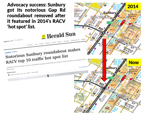
Roundabout removals are projects of similar ilk. Replacing them with signalised intersections (preferably with short light cycles and no slip lanes) can also deliver wide benefits for several types of road user and not just people walking (although that's been my emphasis today). Hence it should be possible to build large local coalitions in favour of removing the most notorious of them across diverse road user groups that would not necessarily agree on other things.
There is also government and political support for roundabout removals including budget funding. Below for instance is the Transport minister (and local member) tweet about the 2020 state budget's funding of two roundabout removals in Niddrie.
One issue is that these, like a lot of bus reforms and how level crossing removals used to be done, are bespoke 'cottage industry' projects done one at a time. Whereas there are so many large multi-lane roundabouts that need removing that a mass removal approach could be better. Like what has been done with the level crossing removals, possibly even with a dedicated agency and a bold performance goal.
One or two billion dollars spread over the next several years could fund a substantial program that would remove many of the worst. In the context of some recently announced transport infrastructure projects that is an affordable cost with widespread benefits across multiple seats.
30 roundabouts that could be considered for removal
Which roundabouts need to go? To decide I jumped onto Google Maps to look across Melbourne, starting in the western suburbs (City of Wyndham). Detailed site visits have not be done, and some might be in the process of removal or even have been done (as things can move quickly in growth areas, making online maps out of date). So don't take this list too seriously. There is no ordering by priority although I comment briefly on each. Links are provided so you can explore the surrounding area for yourself.
1. Wyndham Vale. Ballan Rd. Growth area, across from shopping centre. Likely significant pedestrian activity.
https://www.google.com.au/maps/@-37.8757287,144.6156341,3a,75y,353.7h,83.02t/data=!3m7!1e1!3m5!1soXheDl1sIh-Q4gc9SB6hlw!2e0!6s%2F%2Fgeo1.ggpht.com%2Fcbk%3Fpanoid%3DoXheDl1sIh-Q4gc9SB6hlw%26output%3Dthumbnail%26cb_client%3Dsearch.revgeo_and_fetch.gps%26thumb%3D2%26w%3D96%26h%3D64%26yaw%3D189.47723%26pitch%3D0%26thumbfov%3D100!7i16384!8i8192
2. Wyndham Vale. Ballan Rd. Near above. Residential area with major bus routes.
https://www.google.com.au/maps/@-37.8767457,144.6168799,3a,75y,218.34h,83.54t/data=!3m7!1e1!3m5!1soji2jXHr5Mtk34CUSiuVpw!2e0!6s%2F%2Fgeo1.ggpht.com%2Fcbk%3Fpanoid%3Doji2jXHr5Mtk34CUSiuVpw%26output%3Dthumbnail%26cb_client%3Dsearch.revgeo_and_fetch.gps%26thumb%3D2%26w%3D96%26h%3D64%26yaw%3D139.45259%26pitch%3D0%26thumbfov%3D100!7i16384!8i8192
3. Wyndham Vale. Ballan Rd/Macquarie Dr. Residential area with major bus routes.
https://www.google.com.au/maps/@-37.8836931,144.6236298,3a,75y,278.16h,90t/data=!3m7!1e1!3m5!1sbxOKTVqc1AtFp9RPRog6kQ!2e0!6s%2F%2Fgeo1.ggpht.com%2Fcbk%3Fpanoid%3DbxOKTVqc1AtFp9RPRog6kQ%26output%3Dthumbnail%26cb_client%3Dsearch.revgeo_and_fetch.gps%26thumb%3D2%26w%3D96%26h%3D64%26yaw%3D278.16495%26pitch%3D0%26thumbfov%3D100!7i16384!8i8192
4. Wyndham Vale. Ballan Rd/Greens Rd. Major intersection. Severs residential area with major bus route.
https://www.google.com.au/maps/@-37.8917029,144.6292771,3a,75y,339.18h,90.86t/data=!3m7!1e1!3m5!1srRA0FnzPFDlGPzfJHZCCUw!2e0!6s%2F%2Fgeo1.ggpht.com%2Fcbk%3Fpanoid%3DrRA0FnzPFDlGPzfJHZCCUw%26output%3Dthumbnail%26cb_client%3Dsearch.revgeo_and_fetch.gps%26thumb%3D2%26w%3D96%26h%3D64%26yaw%3D297.28418%26pitch%3D0%26thumbfov%3D100!7i16384!8i8192
5. Wyndham Vale. Ballan Rd/Bulban Rd. Residential area with many bus routes. Walkable to Werribee CBD. Cross and flowers indicate fatality.
https://www.google.com.au/maps/@-37.9029405,144.6513775,3a,42.3y,258.02h,92.74t/data=!3m6!1e1!3m4!1s46_lbO-6c2A-lA4-ua4KNw!2e0!7i16384!8i8192
6. Wyndham Vale. McGraths Rd/Heaths Rd. Residential area. Near major park and playground. Buses pass.
https://www.google.com.au/maps/@-37.8867628,144.6321777,3a,75y,294.03h,101.44t/data=!3m6!1e1!3m4!1shBePK_ymbgIzbNA5GB27Cw!2e0!7i16384!8i8192
7. Werribee. Heaths Rd/Rowes Rd. Also near abovementioned park. Residents need to cross to access park.
https://www.google.com.au/maps/@-37.8870254,144.6357201,3a,75y,288.74h,93.38t/data=!3m6!1e1!3m4!1sJAXF7ntD0dTyJXDYs_5kZw!2e0!7i16384!8i8192
8. Werribee. Heaths Rd/Greaves Rd. Near major park and dog exercise area. Residents need to cross to access park. Buses also serve area.
https://www.google.com.au/maps/@-37.8875511,144.6400642,3a,75y,50.56h,88.33t/data=!3m7!1e1!3m5!1ssTBs4d-suwOGUMcsJH09Ww!2e0!6s%2F%2Fgeo2.ggpht.com%2Fcbk%3Fpanoid%3DsTBs4d-suwOGUMcsJH09Ww%26output%3Dthumbnail%26cb_client%3Dsearch.revgeo_and_fetch.gps%26thumb%3D2%26w%3D96%26h%3D64%26yaw%3D214.82845%26pitch%3D0%26thumbfov%3D100!7i16384!8i8192
9. Werribee. Heaths Rd/Shaws Rd. Most residents must cross to go to church. Also buses in area.
https://www.google.com.au/maps/@-37.8876643,144.6443,3a,75y,322.38h,95.92t/data=!3m7!1e1!3m5!1sdOWimmFXoxSEA6gxn7oX7Q!2e0!6s%2F%2Fgeo1.ggpht.com%2Fcbk%3Fpanoid%3DdOWimmFXoxSEA6gxn7oX7Q%26output%3Dthumbnail%26cb_client%3Dsearch.revgeo_and_fetch.gps%26thumb%3D2%26w%3D96%26h%3D64%26yaw%3D162.14534%26pitch%3D0%26thumbfov%3D100!7i16384!8i8192
10. Shaws Rd/Tarneit Rd. While smaller than some other roundabouts, it's very active. On one side is a busy Werribee Village shopping centre. The area contains significant housing for low income earners and car ownership is below average. Major bus routes operate through the roundabout. Those walking to the nearest high school may also need to cross it.
https://www.google.com.au/maps/@-37.8902481,144.661855,3a,49.2y,5.51h,83.79t/data=!3m7!1e1!3m5!1s1w-ht2VwpDMlv5uINm7rtQ!2e0!6s%2F%2Fgeo2.ggpht.com%2Fcbk%3Fpanoid%3D1w-ht2VwpDMlv5uINm7rtQ%26output%3Dthumbnail%26cb_client%3Dsearch.revgeo_and_fetch.gps%26thumb%3D2%26w%3D96%26h%3D64%26yaw%3D212.79181%26pitch%3D0%26thumbfov%3D100!7i13312!8i6656
11. Werribee. Cherry St/Railway Rd. Near station. Rail has recently been grade separated. More here.
https://www.google.com.au/maps/@-37.8983928,144.6630641,3a,75y,328.15h,76.6t/data=!3m7!1e1!3m5!1se1rk0rukPwbn0UNHvoHZ1A!2e0!6s%2F%2Fgeo3.ggpht.com%2Fcbk%3Fpanoid%3De1rk0rukPwbn0UNHvoHZ1A%26output%3Dthumbnail%26cb_client%3Dsearch.revgeo_and_fetch.gps%26thumb%3D2%26w%3D96%26h%3D64%26yaw%3D236.88223%26pitch%3D0%26thumbfov%3D100!7i13312!8i6656
12. Werribee. Heaths Rd/Purchas St. Roundabout cuts residential area off from Riverbend Historical Park.
https://www.google.com.au/maps/@-37.8813296,144.6495433,3a,75y,357.51h,79.95t/data=!3m7!1e1!3m5!1shZyjhQuY9QQ_wZs5VIw56Q!2e0!6s%2F%2Fgeo3.ggpht.com%2Fcbk%3Fpanoid%3DhZyjhQuY9QQ_wZs5VIw56Q%26output%3Dthumbnail%26cb_client%3Dsearch.revgeo_and_fetch.gps%26thumb%3D2%26w%3D96%26h%3D64%26yaw%3D157.84402%26pitch%3D0%26thumbfov%3D100!7i16384!8i8192
13. Werribee. Heaths Rd/Marina St. Roundabout cuts residential area off from riverside parkland. Children should be able to walk to area without threat from traffic.
https://www.google.com.au/maps/@-37.8781368,144.6529686,3a,75y,55.23h,85.54t/data=!3m7!1e1!3m5!1sCi9frC-CXy4AyjtwFyf_Fg!2e0!6s%2F%2Fgeo1.ggpht.com%2Fcbk%3Fpanoid%3DCi9frC-CXy4AyjtwFyf_Fg%26output%3Dthumbnail%26cb_client%3Dsearch.revgeo_and_fetch.gps%26thumb%3D2%26w%3D96%26h%3D64%26yaw%3D246.23112%26pitch%3D0%26thumbfov%3D100!7i16384!8i8192
14. Werribee. Heaths Rd/Thames Bvd. Two lane Heaths Rd roundabout splits the community, including two schools and a community centre, from itself.
https://www.google.com.au/maps/@-37.8763228,144.6579775,3a,75y,67.43h,92.79t/data=!3m7!1e1!3m5!1s0MZj62vgC6v3UeieADwUag!2e0!6s%2F%2Fgeo3.ggpht.com%2Fcbk%3Fpanoid%3D0MZj62vgC6v3UeieADwUag%26output%3Dthumbnail%26cb_client%3Dsearch.revgeo_and_fetch.gps%26thumb%3D2%26w%3D96%26h%3D64%26yaw%3D28.880928%26pitch%3D0%26thumbfov%3D100!7i16384!8i8192
15. Werribee. Heaths Rd/Tarneit Rd. Busy at all times of day, this is top priority for removal. The roundabout prevents easy and safe access to major bus routes and Werribee Plaza which is within convenient cycling distance.
https://www.google.com.au/maps/@-37.8758981,144.6643138,3a,75y,0.81h,91.06t/data=!3m7!1e1!3m5!1sWAe1WwoH30PB7bICloIPTQ!2e0!6s%2F%2Fgeo1.ggpht.com%2Fcbk%3Fpanoid%3DWAe1WwoH30PB7bICloIPTQ%26output%3Dthumbnail%26cb_client%3Dsearch.revgeo_and_fetch.gps%26thumb%3D2%26w%3D96%26h%3D64%26yaw%3D244.7378%26pitch%3D0%26thumbfov%3D100!7i16384!8i8192
16. Hoppers Crossing. Tarneit Rd/Treeside Dr. Cuts a major residential area off from its most frequent bus route down Tarneit Rd (180).
https://www.google.com.au/maps/@-37.8685154,144.6654227,3a,75y,7.26h,100.02t/data=!3m6!1e1!3m4!1soBWGvcN9wuOkYjVteL6-5g!2e0!7i16384!8i8192
17. Hoppers Crossing. Tarneit Rd/Meadow Way. Cuts a major residential area off from its most frequent bus route down Tarneit Rd (180).
https://www.google.com.au/maps/@-37.8640869,144.6662822,3a,75y,336.36h,90t/data=!3m7!1e1!3m5!1sjr8qmtphmAI19ZYwP4mJuA!2e0!6s%2F%2Fgeo3.ggpht.com%2Fcbk%3Fpanoid%3Djr8qmtphmAI19ZYwP4mJuA%26output%3Dthumbnail%26cb_client%3Dsearch.revgeo_and_fetch.gps%26thumb%3D2%26w%3D96%26h%3D64%26yaw%3D336.3564%26pitch%3D0%26thumbfov%3D100!7i13312!8i6656
18. Tarneit. Sayers Rd/Davis Rd. While a new area, traffic will only increase as the area develops. It's important to have walkable communities from the first day people move in, before they buy their second cars. This is why whenever traffic increases beyond that which is considered desirable for an unsignallised cross roads it should be signalised. Roundabouts should never be built as they can linger as an unsatisfactory stop-gap for 10 to 20 years.
https://www.google.com.au/maps/@-37.8450752,144.6513749,3a,75y,12.18h,92.3t/data=!3m6!1e1!3m4!1s2qDq1Vt4PAbdwrKPbcb6aQ!2e0!7i16384!8i8192
19. Hoppers Crossing. Derrimut Rd/Hogans Rd. Another very high priority for removal with Hogans Corner Shopping Centre and the popular 170 bus at this junction. Heavy traffic at all times. There are pedestrian lights on some legs but they are set way back and walking is indirect.
https://www.google.com.au/maps/@-37.8633606,144.6853056,3a,75y,5.21h,90.65t/data=!3m6!1e1!3m4!1sYDRfYt-fSaMfw4OaXI8o7w!2e0!7i16384!8i8192
20. Hoppers Crossing. Derrimut Rd/Sayers Rd. Also high priority with high all-day traffic volumes. Fast food restaurants are known to be high walking generators for nearby neighbourhoods.
https://www.google.com.au/maps/@-37.8487545,144.6880478,3a,75y,1.78h,95.95t/data=!3m6!1e1!3m4!1sA5FWmlbxn7WqARROlorcPw!2e0!7i16384!8i8192
21, 22 Hoppers Crossing. Morris Rd/Old Geelong Rd & Heaths Rd/Old Geelong Rd. Both greatly impede walkability in the Hoppers Crossing Station area and greatly lessen its walkable catchment. You'd hope both would get removed when the railway is grade separated.
https://www.google.com.au/maps/@-37.8818309,144.7008344,3a,75y,74.19h,87.81t/data=!3m7!1e1!3m5!1stQUUYRZDh9DqAp2o52Hcug!2e0!6s%2F%2Fgeo0.ggpht.com%2Fcbk%3Fpanoid%3DtQUUYRZDh9DqAp2o52Hcug%26output%3Dthumbnail%26cb_client%3Dsearch.revgeo_and_fetch.gps%26thumb%3D2%26w%3D96%26h%3D64%26yaw%3D219.0356%26pitch%3D0%26thumbfov%3D100!7i16384!8i8192
23 Point Cook. Point Cook Rd/Sanctuary Lakes Bvd. Roundabout impedes foot access to major shopping centre and buses.
https://www.google.com.au/maps/@-37.8972027,144.7540043,3a,75y,354.79h,94.17t/data=!3m7!1e1!3m5!1sbzmlrIloY-BOQsL3TGEzAA!2e0!6s%2F%2Fgeo2.ggpht.com%2Fcbk%3Fpanoid%3DbzmlrIloY-BOQsL3TGEzAA%26output%3Dthumbnail%26cb_client%3Dsearch.revgeo_and_fetch.gps%26thumb%3D2%26w%3D96%26h%3D64%26yaw%3D329.2552%26pitch%3D0%26thumbfov%3D100!7i13312!8i6656
24. Williams Landing. Forsyth Rd/Ashcroft Av. Roundabout with likely heavy freeway feeder traffic impedes potential walking access to industrial area jobs. Area is also a short bicycle ride from Williams Landing Station.
https://www.google.com.au/maps/@-37.8673207,144.7342684,3a,75y,111.77h,84.26t/data=!3m7!1e1!3m5!1s-Ww_TK55jOiYEEhRYYgI0g!2e0!6s%2F%2Fgeo3.ggpht.com%2Fcbk%3Fpanoid%3D-Ww_TK55jOiYEEhRYYgI0g%26output%3Dthumbnail%26cb_client%3Dsearch.revgeo_and_fetch.gps%26thumb%3D2%26w%3D96%26h%3D64%26yaw%3D224.0648%26pitch%3D0%26thumbfov%3D100!7i16384!8i8192
25. Williams Landing. Ashcroft Av/Rothbury Pkw. Roundabout lessens walking access to town centre and station from substantial residential pocket.
https://www.google.com.au/maps/@-37.8656431,144.7382244,3a,36.4y,56.64h,89.67t/data=!3m6!1e1!3m4!1s6hiRx0bNv4cJKym8r8vdGQ!2e0!7i16384!8i8192
26. Truganina. Palmers Rd/Dohertys Rd. Major industrial and employment area with many heavy vehicles. Bus service uses roundabout. Poor walkability to stops in area.
https://www.google.com.au/maps/@-37.8250031,144.7493068,3a,75y,275.63h,94.7t/data=!3m7!1e1!3m5!1s5oStyXrtrEP6Drp29Yxs3Q!2e0!6s%2F%2Fgeo2.ggpht.com%2Fcbk%3Fpanoid%3D5oStyXrtrEP6Drp29Yxs3Q%26output%3Dthumbnail%26cb_client%3Dsearch.revgeo_and_fetch.gps%26thumb%3D2%26w%3D96%26h%3D64%26yaw%3D252.95705%26pitch%3D0%26thumbfov%3D100!7i16384!8i8192
27. Derrimut. Palmers Rd/Robinsons Rd. Heavy traffic. Many jobs. Bus passes.
https://www.google.com.au/maps/@-37.8106887,144.750768,3a,75y,351.03h,88.46t/data=!3m6!1e1!3m4!1shdsFY0IK9YKqG6R1qotMqg!2e0!7i16384!8i8192
28. Laverton North. Fitzgerald Rd/Dohertys Rd. Heavy traffic. Many jobs. Bus passes.
https://www.google.com.au/maps/@-37.8136,144.7867647,3a,75y,77.72h,92.3t/data=!3m6!1e1!3m4!1sThE2wn8vVnQ6QRlT9fnc7g!2e0!7i16384!8i8192
29. Tarneit. Derrimut Rd/Dohertys Rd. Major intersection with fast developing residential area surrounding. Potentially cyclable to Tarneit Station.
https://www.google.com.au/maps/@-37.8196586,144.6933618,3a,75y,70.57h,80.51t/data=!3m6!1e1!3m4!1sLx0eEA-44ej_hf3ZlSm_lw!2e0!7i16384!8i8192
30. Tarneit. Tarneit Rd/Dohertys Rd. Needs signalising before people move in. Walking access is important due to proposed bus routes 154 and 155 in area.
https://www.google.com.au/maps/@-37.8177882,144.6753393,3a,75y,333.5h,94.81t/data=!3m7!1e1!3m5!1sLtj5YRSyEsLhT77YjyGcxw!2e0!6s%2F%2Fgeo1.ggpht.com%2Fcbk%3Fpanoid%3DLtj5YRSyEsLhT77YjyGcxw%26output%3Dthumbnail%26cb_client%3Dsearch.revgeo_and_fetch.gps%26thumb%3D2%26w%3D96%26h%3D64%26yaw%3D200.3209%26pitch%3D0%26thumbfov%3D100!7i16384!8i8192
Conclusion
There's so many of them. I got up to 30 without having to leave the City of Wyndham. There are no doubt dozens more in other parts of Melbourne's west, north, east and south, such as the one in Altona below. Ones like these may be a higher priority for removal than some listed above. Getting to such a high number just in one small part of Melbourne shows the magnitude of action needed to make our roads and intersections fit for everyone, not just car drivers.

Even if only half of those listed were considered ripe for removal, it would still be a big (but very worthwhile) job ahead with very broad community benefits. Hence a large scale $1-2 billion roundabout removal program could and probably should be a major element of the transport policy for any party contesting the 2022 election, with the aim of removing the 100 worst across Melbourne by 2026.
In addition there could be a blanket ban on converting cross road intersections to roundabouts, particularly in residential growth areas. If traffic is a problem for cars then it will be also be problem for walkers. Thus the right solution for everyone cannot involve large roundabouts for reasons explained before. Instead good walkability should be designed in from Day 1 so that people find active transport convenient as soon as they move in. This may mean early signalisation of intersections that are, or are earmarked to become, major.
I'd like your thoughts. Where else should roundabout be removed? Are 'Dutch style' roundabouts a viable option in some places? And how would a mass roundabout removal program compare for value for money against other road projects?


