Links

Friday, January 29, 2021

Building Melbourne's Useful Network Part 79: A Rowville TrainLink


It takes almost an eternity to get from most of residential Rowville to anywhere else by public transport.  That includes to surrounding areas where there's lots of jobs such as in the Monash precinct. And as soon as you get a few hundred metres away from Stud Road connections to trains for longer distance travel are equally weak. Yes, the new FlexiRide works, but it's only local, only weekday and is not scale-able with high operating costs per passenger. 

There is no more disreputable person in state politics than one who promises (or raises expectations on) public transport upgrades (especially rail) in Rowville. There's been many examples over the years. In each past case the plan has been quietly left to die and nothing much happens (background here). At best it's been a bait-and-switch trick (though sometimes the project being switched to has merit in itself). 

The only significant boost to Rowille's public transport in most peoples' living memory occurred about 12-15 years ago under the Bracks-Brumby government. The 900 SmartBus substituted for something two rail promises ago. And a little later the infrequent 665 Stud Rd bus between Ringwood and Dandenong got upgraded to be part of the 901 SmartBus. Neither route penetrates the largest residential areas and even access to Stud Park Shopping Centre is poor, being via an alley ending near a busy roundabout. Below shows the walk between the 900 bus and the local bus interchange at Stud Park. 


Existing services

If you're one of the lucky few near its stops, the 900 SmartBus is great for getting to the Monash Clayton campus. The same can be said for the 901 to Ringwood, Knox City and Dandenong if you're near Stud Rd. 

But there's problems for other trips. The 900 skirts the southern part of the Monash precinct. There's many jobs in its northern part it doesn' t serve. 

Also the 900's nearest train station is Huntingdale. That is three of eastern Melbourne's mile blocks west of Glen Waverley. Glen Waverley is the terminus of a quieter line whereas Huntingdale being an intermediate station on Melbourne's busiest line. Hence morning passengers are guaranteed a seat on the former but not the latter. And, where there's a choice, encouraging Glen Waverley line usage is good for load balancing across the network and relieving the under-pressure Dandenong line. 

As it happens there are already buses from the Knox area to Glen Waverley. It's just they are not all that good. 30 to 60 minute frequencies are typical and there can be confusing variations. 

I discussed a Knox City to Glen Waverley upgrade, involving an upgraded Route 737, here.  Because the 737 roughly follows the proposed Suburban Rail Loop between Monash Clayton and Glen Waverley, I've suggested it as a candidate for a SRL SmartBus at least as far as Knox City

What about further south, like Stud Park? That has the Route 754. It's complex with three route variations. The main version runs all day. AM express trips operate via Ferntree Gully Rd. PM express trips run via High Street Road.   


Services operate half-hourly weekday off-peak and hourly weekends. Peak service on the full-time route is roughly every 20 minutes with some 40 minute gaps. Express trips are roughly every 40 minutes. Travel time is 20 - 26 minutes on the express trips (am peak) versus up to 40 minutes for the regular route. There's four express trips each way over approximately a 90 minute window. This is quite restrictive for those who wish to start early or late or 'spread the peak' to socially distance or take advantage of cheaper off-peak fares about to be offered. 


A full time limited stops/express service

How can we improve connectivity from Rowville to a range of destinations with revised bus routes? There's several approaches. 

The one I settled on involves a simplified Route 754. I don't call it that though it uses the exact same route alignment as the express 754 takes in the morning. The difference is that it would run all day at increased frequency and operating hours. It has a small number of intermediate stops in locations that are remote from good service but have jobs and residents nearby. But to offset any time penalties buses run through the residential area to Ferntree Gully Station. Thus it feeds trains on two lines unlike the current 754. 

The concept is mapped below (click for a better view). 


Rowville is too big to be served by one main bus route. It is also not particularly dense and does not have great demographics for high all day public transport usage (partly due to a history of poor service and high car ownership). Hence I've got the TrainLink service as a two-route corridor from Glen Waverley with the routes splitting in the residential area before combining again before Ferntree Gully Station. One route is a modified 691 (which already runs in the area) while the other is a new route that I've called 692 (which existed in a somewhat similar form in the 1980s). The timetables for both routes are evenly spaced and timed to meet every train at Glen Waverley. Hence trips on each route meet every second train.

Their continuation via a direct alignment to Glen Waverley (at all times) replaces the complex and varying Route 754. Also Route 691 would no longer operate to Waverley Gardens. This is not considered a great loss for reasons explained here

691/692 would be all stops services between Ferntree Gully and Stud Park. However it would only stop a few times between there and Glen Waverley. This reflects the need for a good travel speed. The small number of stops (identified as white dots on the map) would bring much upgraded services to areas considered to warrant it due to a significant catchment of jobs or residents. 

A special design feature is a same-stop interchange between the 691/692 Trainlink and the 693 bus on Ferntree Gully Rd. This route services jobs in the Monash precinct further north than are serviced by the 900 on Wellington Rd. Ideally Route 693's service level should be boosted to allow easy interchange with referring to timetables or carefully planning travel. Ways to do this economically are given later. 

What happens to the existing all stops Route 754? It stays pretty much the same. Except that instead of going east to Stud Park it goes south to Waverley Gardens. Those who still need to make a 754 - Stud Park trip could still be catered for with a stop near where the route intersects with the 691/692 on Ferntree Gully Road. 

This network will need more buses and driver hours than runs in the area today. For maximum cost-effectiveness it should be done in conjunction with reform to Routes 681 / 682 as well as the Rowville FlexiRide. If you wanted a 'bare bones' option then running 691 and 692 at only an hourly frequency would provide a combined 30 min to Glen Waverley, ie similar to what the 754 does currently off-peak. While even that would overall be better than what currently runs (especially which regard to operating hours and legibility) it wouldn't seriously shift large numbers from driving to buses.  

Other measures

The abovementioned changes should be relatively simple in that it doesn't require a huge bus network restructure involving numerous routes. Apart from the 691, the main services you'd reappraise are the 681 and 682 as well as the new FlexiRide. 

However it is expandable. I mentioned the 693 before. Currently a large part is overlapped by the 753. If the 753 was deleted or dramatically shortened scope may exist to boost 693's frequency for little cost. However where 753 has unique coverage you may wish to replace it with a route extended from somewhere else. A example is Watsons Rd in Glen Waverley that could be served by extending the 848 from Brandon Park to Glen Waverley. Also the Boronia end of the 753 could be replaced by a 690 extended to Knox City, which would connect thousands to the area's main shopping centre.

Many of Melbourne's eastern suburbs are politically marginal. And a redistribution is looming that will see major changes to most seats. Frequency improvements on the Ringwood and Glen Waverley train lines (eg to 10 min off-peak, 20 min night) might be the sort of thing that will increasingly get spoken about before the next election as relatively economical 'local wins' to implement or promise. After all Frankston trains will get this exact level of service in two days and it's quieter than Ringwood.  If this is done then the 691/692 TrainLink corridor should follow suit with a 10 minute daytime/20 minute night frequency.  

The Glen Waverley - Rowville - Ferntree Gully Trainlink bus itself would benefit several seats including Mt Waverley (Matt Fregon MP - marginal Labor), Mulgrave (Daniel Andrews - Labor), Rowville (Kim Wells MP - Liberal) and Ferntree Gully (Nick Wakeling - Liberal). 

Conclusion

Due to Rowville's lack of rail infrastructure buses need to be good, especially with regards to frequency and travel time. There are some parallels with Doncaster/Manningham though Rowville has a lower proportion of CBD workers. Hence we need to think more about those who work locally, including in the Monash precinct. The 691/692 TrainLink should make a worthwhile contribution to such connectivity, especially if it is introduced along with bus priority measures (to make it more BRT like) and considered in conjunction with other network reform such as locally around Rowville/Lysterfield and that which enables upgrades to important intersecting routes such as the 693. 

If TrainLink is done then maybe people might forget about the April 2018 Caulfield - Rowville tram promise on which the government has been suspiciously silent.  TrainLink has the benefit of delivering enhanced service along a new corridor to new destinations. That's something the tram would not do as much of since it would basically replace the 900 SmartBus.  

Thoughts can be left below. Maybe there's too many or too few stops on the express portion? Could another alignment be chosen? Or is heavy rail really the only real solution, such as a former PTUA policy to extend the Glen Waverley line or an alternative from Huntingdale via Monash?


See other Building Melbourne's Useful Network items here

Tuesday, January 26, 2021

Timetable Tuesday #102: The City Loop - Melbourne's train vortex?


40 years ago today revenue services began on the Melbourne Underground Railway Loop, or, to give it its snappier common name, the City Loop. Prior to that travel to the northern and eastern end of the CBD required a train to Flinders St or Spencer St and a tram across. Daniel Bowen has a more detailed write-up here

The City Loop improved the rail system's coverage in the abovementioned parts of the CBD and stimulated development, particularly in the area around Melbourne Central. Some credit it as the start of a revival in patronage after suburban train usage bottomed out in 1981 (at numbers far less than the bullish forecasts in the 1969 plan). However it was not an unalloyed good, introducing changes and confusion where they previously didn't exist. 

Although Parliament, Museum (Melbourne Central) and Flagstaff looked like Metro or subway stations, the trains that went into them were the normal Australian cross between regional and urban rail. Services ran all day but not that frequently. Passengers used timetables rather than turned up and went and there were numerous types of express stopping pattern on the longer lines (as there remains today, notably for Ringwood). 

The City Loop made cross-city trips harder. Changing from one line to another became a horrid chore, not least due to inconsistency that was almost impossible to plan and remember. Due to the convoluted operations of the City Loop trains could use different platforms on different days of the week, go different directions on different times of the same day and require changing at different locations. Then, for decades, there were stations that were only open on some days of the week. Because of this inconsistency permanent signs could not be installed. Instead passengers were at the mercy of electronic displays that could go blank or show wrong information with seconds to go before the train arrives. 

And instead of having a single pulse frequency, like all other Australian suburban rail networks had (typically every 15 minutes in Sydney and Perth, 30 min Brisbane and Adelaide), Melbourne's off-peak trains were a mix of every 15, 20, 30 and 40 minutes. That added to the unpredictability of interchange, even if everything was running to time.   

The sort of inconsistencies that plague back street bus routes that have been unreviewed for decades came to infect, at a hundred times the scale, on our suburban rail network. 

Big cities don't impose this sort of thing on their rail passengers. However Melbourne is a curious mix of big city infrastructure and small city operating practice with regards to things like operating consistency and frequency.  As well as the types of trips, with peak period CBD travel most favoured in timetables.

Hence, although one can admire the engineering audacity of the project, commenced at a time that suburban rail was in decline, it is also possible to see the Loop as a hindrance as much as a help for some trips. Which is a poor return for the network given its mammoth cost. 

People think building the City Loop took ages. It started in the early '70s and finishing in the mid-80s (when the last station opened).  

But that's nothing. Service reform to its operations can take several times longer, especially where, as in Melbourne, decades may pass where the will to pursue it varies between zero and weak. It remains a work in progress, with a substantial step forward occurring this Sunday, January 31 as operations of one of its four portals being made consistent all day and all week. It is hoped that future reforms will be faster than one per decade, with the Burnley group potentially a high priority due to its currently complex operations and coverage of marginal seats

Measuring the midday gap

It wouldn't be Tuesday without at least some look at timetables. Especially timetable oddities. Which the City Loop causes due to its midday reversal on three of its four portals. This is probably the most egregious example of the City Loop's confusing operating pattern. While it might have resulted in some marginal travel time savings for commuters making certain types of trip (such as Melbourne's eastern and south-eastern suburbs to Parliament) it made many others longer. Explaining the vagarities of the  sometimes reversing loop was always in the too hard basket for PTV, Metlink, its predecessors and train operators so they never bothered despite rampant public confusion. 

Hence this attempt by PTUA to explain the City Loop . And the long-running 'Zen and the City Loop' page that I reviewed here


Another risk is 'kidnapping' where a loop train might show one destination that passengers assume it will go to. This can happen on trains that passengers board in the City Loop. What can happen is that once the train gets to Flinders Street it is sent off somewhere else, unbeknownst to the passenger. Such transposals have operational advantages in assisting recovery from delays. However they don't aid network legibility, simplicity and confidence. Consistent patterns, through running and sectored operation should reduce the network's interdependencies and number of transposals.

The good news is that progress on this front is being made, though in time-lines measured in decades. One can look at old timetables like on Krustylink to see examples of lines where trains alternate between loop and direct. That inconsistency made services somewhat less than turn-up-and-go, even in peak times. There were some small consistency improvements in the '90s and 2000s, though these were generally lean times for trains. 

Then about ten years ago the Clifton Hill group became the first loop portal to scrap the midday reversal. Now trains go clockwise around the loop seven days. 

The same will happen for the Caulfield group this Sunday, with Cranbourne and Pakenham trains operating anticlockwise and Frankston trains consistently out of the loop and running to Newport and beyond via Southern Cross. For now though it's got the midday reversal on weekdays. 

Here is a tabulation of when the last train is at various loop stations in the morning direction and the first train in the afternoon direction on non public holiday weekdays. All times are pm. 


Caulfield Group (no reversal from 31/1/2021)

Parliament 12:45 - 1:09

Melbourne Central 12:47 - 1:07

Flagstaff 12:49 - 1:05


Burnley Group

Parliament 12:42 - 1:05

Melbourne Central 12:44 - 1:03

Flagstaff 12:45 - 1:02


Northern Group

Flagstaff 12:48 - 1:03

Melbourne Central 12:50 - 1:01

Parliament 12:52 - 12:59


To summarise, Parliament sees no trains on any line between 12:52 and 12:59, Melbourne Central 12:50 and 1:01 and Flagstaff 12:49 and 1:02. The longest gap per group at any station is 24 minutes at Parliament for the Caulfield group (though this will soon vanish). That is closely followed by the Burnley group at Parliament with 23 minutes. These intervals are longer than the normal frequency on these lines (10 or 15 minutes). Hence if you find yourself at a Loop station in the middle of the day your waiting time can exceed the train frequency if you arrive at the wrong time. 

This is not how big city transport is supposed to work. Neither does it optimise usage of expensive infrastructure whose most efficient usage is likely to be in the form of a consistent, connective and versatile network useful for diverse trips beyond the suburb - office peak hour transit that some excessively focus on.  

At 40 the City Loop has done much good but has not fully lived up to its potential as a consistent simplifier of rather than a some-time hindrance to metropolitan train travel. Simplification of the Burnley and then northern group to remove the midday reversals are essential. 

After that it could be worth considering more radical capacity-enhancing surgery such as opening parts to facilitate direct Richmond - Parliament - Melbourne Central - Flagstaff - North Melbourne trains. After all most people want to get from A to B, and not around a loop whose geometry suits sightseers more than the majority for whom transport is merely a means to something else. 


See all Timetable Tuesday items here


PS: Curious about public holiday timetables such as applying today? Read the public holiday gamble on Melbourne's buses

Friday, January 22, 2021

Building Melbourne's Useful Network Part 78: Saving 2 million annual passenger minutes - The Frankston line stations we could possibly do without

The Labor government is getting more brazen with its level crossing removals. Although the policy to remove crossings has bipartisan support, the method did not, with noisy but largely baseless opposition to elevated rail. This is despite advantages at some sites including lower construction costs, shorter disruptions, better ground-level permeability and retention of vegetation. 


Political considerations were a major element of projects designed and built during Labor's first term (2014 - 2018) when it had a slim majority. However the 2018 landslide gave it increased confidence. Hence last month's announcement that as part of grade separations on the Ringwood line, Surrey Hills and Mont Albert (which are 800 metres apart) would be replaced by a single station in the middle.

This would be in the seat of Box Hill, one of Labor's more marginal seats. Although to be fair that was an unexpected win. Labor could lose it and similar surrounding seats without losing office. Especially given the coming electoral redistribution which will transfer seats from the low-growth east to the high growth west, north and south-east where Labor is (mostly) stronger.  

What if boldness prevailed on the Frankston line?

This post is a hypothetical. What if such boldness (some might say brazenness or even arrogance) was in force when Frankston line grade separations were being designed? We might have got an elevated rail solution for Edithvale/Chelsea/Bonbeach. Then all three stations would have provided a similar view that Carrum has newly become famous for. Instead of a bay glimpse at just one station it would be over a longer section of track. And there would be better road and walking permeability with less of a need to close or merge some crossing points. That's locally important as most residents must cross the rail corridor to reach local shops and the beach. 

Even more radical (at least for train users) is the location of stations or even their existence. Changes to the latter was not on the agenda for Frankston line grade separations. However maybe it should have been, especially if we are as interested in building a first-class rail network as improving road traffic flow. 

The Frankston line trend: more frequent but slower

Frankston line service trends over the last 25 years can be expressed in frequency and running time. One trend has been positive while the other has been negative. 

On frequency it's been unambiguously a good news story. Daytime trains are now twice as frequent as they were in the early '90s, with a weekday increase from 20 to 15 to 10 minutes. Weekends went from 20 to 10 minutes for most of the day, with an even bigger increase on Sundays. And evening service, still lagging on most lines, will increase from every 30 to every 20 minutes on the Frankston line at the end of this month.   

While there's less waiting, travel times are a story of continually decreasing speed. Frankston passengers once enjoyed off-peak express running through Hawksburn, Toorak and Armadale. That privilege got swapped with the Dandenong line for admittedly sound reasons (including it being busier). A late morning off-peak trip from Flinders St to Frankston took 58 minutes in 1997 before that change. 

The new Southland Station also added some time, though the timetable was altered well before the station was built. Subsequent timetables have added a minute or so each time in running time. Padding timetables can be seen as catering for increased patronage, improving reliability, making punctuality targets easier to achieve or reducing operator lateness penalties. Today a weekday morning trip from Flinders Street to Frankston takes 66 minutes. However this will increase to 67 minutes with the January 31 timetable. This is for a distance of 43km from the CBD.

Competition with roads

The speed limit for traffic in local streets in Melbourne is 50 km/h. Local shopping strips, with high pedestrian activity, often have a 40 km/h limit. Yet our suburban trains, on their own right of way, have average speeds measured in the thirties, even off-peak where fewer boarding delays can be expected. The Frankston train line is no exception, with an average 38 km/h speed. Peak express trains exist but speeds are only slightly higher, with a typical 59 minute travel time. That's slower than the off-peak service in 1997.  And to compensate for loading delays the all stations trip has been inflated to 111 minutes during peak times. 

Road, rail's competition, enjoys 100km/h speed limits on vaguely parallel freeways like Eastlink, Peninsula Link, and the under construction Mordialloc Bypass. None of these existed in 1997. These compete with rail for many trips, especially from areas with infrequent, slow or backtracking bus routes or to jobs with poor transit access such as at Carrum Downs or in the Monash precinct. 

To summarise, Frankston line rail travel is unattractively slow, and it's been getting slower over time. And Frankston line patronage has been falling, particularly on the outer portion. Some could be attributed to frequent shutdowns due to construction works but not all. 

The main train lines are public transport's version of freeways yet their speeds are more like local traffic. If a trip needs connections to slow or infrequent buses then travel time blows out further. This is particularly an issue for Frankston due to the extension of near continuous suburbanisation, mostly on two increasingly narrow corridors, a further 20 to 30 kilometres beyond where frequent rail stops. Public transport travel time to Melbourne from much of the Mornington Peninsula is rarely under two hours, even during off-peak times.  It can be faster to get public transport from Melbourne CBD to Ararat than to parts of the peninsula, despite the latter being about half the distance. 

Around Australia, similar comments may apply for the Gold Coast, whose train is also relatively slow. Mandurah is nearly twice the distance from Perth as Frankston is from Melbourne yet its trains are vastly faster due to wide station spacing. While Mandurah's local buses are infrequent (like Frankston's), the rail they feed offers a vastly faster trip than driving, something that the Frankston line does not necessarily do. The trade-off though is that with many more stops, including shopping centres like Southland, local connectivity for radial non-CBD trips is better than for the Mandurah line.  

Optimum station spacing for the Frankston line

Which brings us to what is ideal for the Frankston line. More stations equals more walk-up coverage but less speed. Fewer stations equals less walk-up coverage but more speed. The latter can still have wider coverage with a good feeder bus network but rarely are the buses as frequent as trains. Plus there's a transfer penalty that increases door-to-door travel time. You also need to bear in mind that walking is the main access mode to most Melbourne suburban stations and distance is a key factor of whether the service is considered useful. But when stations are too close they eat into each others walking catchments and don't add much new catchment. 

One approach is to keep all the stations but have express services. This reduces frequency at the stations skipped for a given number of trains. Skipping one or two stations doesn't greatly reduce travel time (although it somewhat reduces peak capacity on a two line system) while skipping three or more is not practical if a high frequency operates without signalling upgrades and, ultimately, extra line capacity. 

Where stations are very close so that large parts of their catchments are within a short walk of two stations on the same line, stations can eat into each other's catchments. With only a small unique catchment it's worth considering whether all stations should remain open since many passengers would almost as easily be able to walk to stations either side. When you reduce the number of stations you can speed the service without having to introduce confusing skip-stop express running (tried but abandoned in Perth) or reducing service frequency at some stations due to express running.

As I mentioned before, the Frankston line is an increasingly slow railway that is not necessarily attractive to those with the choice of using a parallel freeway. With good 7-day daytime frequency and reasonable (but still not great) evening frequency instituted from January 31, the next major priority for improvement should be travel time. 

Improved travel time involves various small and large changes. These are the sorts of things that a government focused on big infrastructure can overlook. And some, like reducing the number of stations, can provoke a political backlash, even though the vast majority of passengers might benefit. 

Removal options

Which stations on the Frankston line might one remove? 

Station usage could be helpful information. Numbers are available from this Philip Mallis blog post. Though note potential volatility in some years due to line closures and bus replacements. 

Bonbeach, Aspendale, Kananook and Edithvale are in the quieter group. Bonbeach is 1.3km south of busier Chelsea and 1.5km north of Carrum (before it was rebuilt and moved south). Aspendale is a similar distance north of Edithvale which in turn is 1.7km north of Chelsea. However Aspendale is distant (2.6km) from Mordialloc.

Proposed grade separations will move Chelsea south and Edithvale north, making spacings more uneven than previous, with Edithvale closer to Aspendale. Edithvale loses denser residential catchment than it gains to the north (part being a golf course) as well as access to the area's main bus (902). Hence both it and Aspendale may lose catchment from the grade separation, although Edithvale gains somewhat by users no longer having to wait for trains to reach the platform (Aspendale doesn't as it, like Chelsea, has an underpass). 

Kananook is further from stations either side. Seaford is 2km north and Frankston is 2.5km south. 

None of these distances are super close by Melbourne station separation standards. As comparison, Riversdale and Willison on the quiet Alamein line are just 600 metres apart.

Assuming station walking catchments are 800 metres, and they are seen as a rough circle around each station, stations need to be 1600 metres apart for them not to have any overlap where stations eat into each other's catchment. Of the distances quoted above, the closest two are Chelsea and Bonbeach, though this spacing is likely to widen as Bonbeach is moved significantly south and Chelsea moved slightly south. The movement of Edithvale north opens a gap between it and Chelsea (which is populated) while overlapping Aspendale near the unpopulated golf course.

We also need to think about those away from the rail line whose walking distances may be increased if a station is moved (or even removed). A factor here that's important is that stations align with the main east-west road. In the case of Edithvale, Chelsea and Bonbeach all three stations are being moved further from their main east-west road. This makes access to them less legible for those coming from 1.5 to 2 km away. The same has happened for Mentone, which I regard as a flawed project due to the new station's less convenient position south of the main activity area. 

To summarise, if we view the Frankston line as a walk-up medium speed railway (some might argue we shouldn't with something like the fast Mandurah line, being a pace-setting example) then the station spacing on this part of the line is not overly close. However that is not so further north, where spacing is more like a metro system in a dense European city. European cities are more compact and they don't have the metro doing double duty as a regional rail type service (as the Frankston line tries to, being the main feeder to areas as far as 70km from the CBD, via the infrequent 788 bus).

Patterson


Patterson is another of the quieter stations. It is 800 metres south of Bentleigh and 900 metres north of Moorabbin (for which big things were planned in the '50s but little happened). A few shops surround the station. It is served by no buses. For a long time it suffered as being the first station exclusively in Zone 2, with much of its catchment walking north to Bentleigh to take advantage of cheaper fares. 

Patterson opened in 1961, during a time when train patronage was falling. It would have brought trains closer to parts of newly developing Bentleigh East. However one could query whether it added more patronage than was lost by Frankston line trains being made slower. Closing it could save passengers one minute each way, or two minutes per day. It doesn't sound much but it is when multiplied over a year. Such savings would be at the expense of the relatively small number of Patterson Station users who would need to walk in the very worst case 800 metres more (and usually much less).


Patterson features an elevated platform somewhat cut off from its surrounds. The road already passes underneath so it has not needed to be rebuilt as part of the level crossing removal program. The removal of higher Zone 1+2 fares may have brought back patronage that was previously lost to Bentleigh. However too much of its walking catchment is overlapped by either Bentleigh and Moorabbin. Still, little has been spent on the station for years, and it shows! 

McKinnon

The same cannot be said for McKinnon Station. Relatively minor McKinnon Rd got grade separated around the time that busier North and Centre Rd did. That meant the station got rebuilt into something grand. Watch the opening festivities here. 


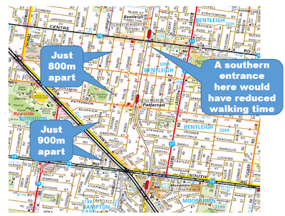
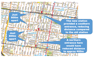
Should McKinnon have been rebuilt? It's busier than Patterson. And for that matter stations down the line like Bonbeach and Edithvale. However it is much closer to stations either side as per the map below: 


The 800 metre spacing gives it very little unique catchment given that stations either side are 1600 metres separate. The unique catchment would have been even less if we had provided Bentleigh with an extra northern entrance. Unfortunately multiple station entrances is something designers too often scrimp on. 

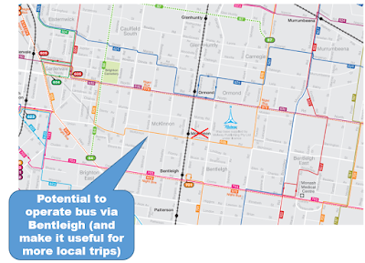
Unlike Patterson, McKinnon does have a bus (the 626). However if the station was closed it could be rerouted via Bentleigh. This would probably make the route busier due to a new connection to the thriving Bentleigh shops. And it would provide a direct route to Carnegie, another developing area. 


Benefits and disbenefits 

Station closures to speed travel typically have asymmetrical benefits. That is many passengers gain slightly while a small pocket of passengers near the closed station lose a lot more. The latter can make station closures bad politics as people who have had something taken away make more noise than those who would stand to gain. 

Here are some numbers to help quantify whether closing the two Frankston line stations with the most overlapping walking catchments would be for the greater good or not. 

Patterson

2018/9 annual station boardings (Patterson): 354 000
2018/9 annual station boardings (Moorabbin - Frankston): 8 317 000 

I will assume the following: 
* 100% of access to Patterson is by walking (an overestimate)
* Patterson passengers will walk an extra 5 minutes on average to Moorabbin or Bentleigh
* Expressing trains through Patterson will save an average 1 minute in travel time
* One-third of Moorabbin - Frankston passengers will benefit from above (those who don't are either on express trains or are using the train for local trips) 

Annual extra minutes for Patterson passengers: 1 770 000 minutes extra
Annual saved minutes for Moorabbin - Frankston passengers: 2 772 000 minutes saved
Overall annual saved minutes: 1 000 000 (but could be higher)

McKinnon

2018/9 annual station boardings (McKinnon): 450 000
2018/9 annual station boardings (Bentleigh - Frankston): 9 398 000 

I will assume the following: 
* 100% of access to McKinnon is by walking (an overestimate)
* McKinnon passengers will walk an extra 5 minutes on average to Ormond or Bentleigh
* Expressing trains through McKinnon will save an average 1 minute in travel time
* One-third of Bentleigh - Frankston passengers will benefit from above (those who don't are either on express trains or are using the train for local trips) 

Annual extra minutes for Patterson passengers: 2 250 000 minutes extra
Annual saved minutes for Moorabbin - Frankston passengers: 3 132 000 minutes saved
Overall annual saved minutes: 900 000 (but could be higher)

Conclusion

Patterson station should be demolished and McKinnon should not have been rebuilt

Very roughly closing Patterson and McKinnon stations could save Frankston line passengers nearly 2 million minutes per year. That number may well be higher as it doesn't count those boarding at stations north of those considered travelling towards Southland/Frankston. Neither have I counted Stony Point line passengers  (around 100k boardings/year) as I'm assuming that their travel is primarily local/Frankston/Southland. Plus non-walking access (normally faster with a wider choice of surrounding stations) hasn't been considered. Hence overall time savings could well be more. 

Two million saved minutes per year is over 30 000 saved hours or 1300 saved person-days. That's a big number! Transport infrastructure and service planners should be considering these sorts of benefits when designing projects and services. That includes smaller infrastructure and signalling projects that can save a minute here and there (eg train speeds on the approach to Frankston often appear slow), along with more efficient operational practices. If these are done time savings could be even higher. 

A bolder Frankston line grade separation program could have included works that closed Patterson and not rebuilt McKinnon. Bentleigh could have got a northern entrance to assist current McKinnon passengers. And dingy Moorabbin could have got a needed facelift, with better access to the north, including across South Rd, to assist current Patterson passengers. 

Other offsetting project could have included (a) improved 7 - 9am Sunday morning train frequencies, especially outbound direction, (b) full time staffing at Ormond Station and (c) major bus operating hours and frequency upgrades on major routes such as the 630, 703 and 824, local routes (like 625, 626 and 823) and a new East Boundary Rd SmartBus and (d) better, ie multimodal, passenger information at stations. The bus changes, especially would benefit a much wider area, particularly suburbs just beyond walking distance from station such as Bentleigh East. And they would aid a lot of short distance local travel. 

Wider station spacing where walking catchments eat into one another would provide all-day faster service on the Frankston line without having to compromise frequency by having some trains operate express and others stop all stations. Also coverage would be substantially preserved. 

Politically acceptable alternatives, assuming we are planning on keeping Patterson and do not wish to close the near-new McKinnon, could be an all day two tier express/stopping service with each tier operating every 10 minutes. This would be operationally dearer but give some travel time savings. And frequency would be compromised per operational dollar spent, especially at night when driving is so much faster. But if we're not closing too-close stations, finding alternative means of speeding the service is essential given the current slowness of Frankston line travel and competition from road, which is faster for some trips it shouldn't be. 

Comments are invited and can be left below. In particular discussion on the pros and cons of this and other station closures or mergers is encouraged. 

Tuesday, January 19, 2021

Timetable Tuesday #101: New bus timetables for the new train timetables

New train timetables are starting on January 31 on many lines. Some 450 services are being added with many more trips moved in time. Bus timetables are also changing, with the stated intention being to fully align all bus services with the new rail timetable

However the bus time revisions won't happen all in the one go. The first lot will happen on the same day when the train times change (January 31). More timetables will be revised on 28 February. The third and final stage will be 11 April. 

The above link lists routes whose times are changing first. It's a substantial effort, involving over 90 routes.  

The most conspicuous non-inclusions in the first round are buses in Ballarat and Melton.

Both bus systems operate at a base frequency of 30 or 60 minutes. That is compatible with trains that are hourly for Ballarat and two trains per hour for Melton (on weekdays). The upgraded train timetable boosts Ballarat to every 40 minutes (off-peak) and Melton to every 20 minutes. Hence there will be a period of one month (best scenario) or 2.5 months (worse scenario) of broken harmonisation between trains and buses. That is trains with a 20/40 pulse trying to be met by buses every 30 or 60 minutes.

On the other hand it could be argued that fewer passengers will be affected compared to say Wyndham (especially Point Cook) where there are many more bus+train multimodal passengers. Bus routes in Wyndham will eventually get revised timetables but not in this first tranche.  

Bacchus March, in between Ballarat and Melton, in contrast, does get new timetables on the 31st. That is good since Bacchus Marsh is one of the Ballarat line stations getting the biggest changes to its train times. 

Also getting a change is Brunwick's Route 509, an hourly shopper route whose passengers are not very likely to connect with trains. It wouldn't feature if you wanted to do the most important routes first. However timetabling is closely related to driver rostering. Even if only some operators' routes need rescheduling then it may be expedient to adjust times of them all to maintain rostering efficiency.    

A good touch is that Night Buses are amongst those getting new timetables in the first round. If that wasn't the case then connections between hourly trains and these (also hourly) would be thrown out. 

Casual readers might take PTV at its word with regards to fully aligning bus services with the new train timetable. Unfortunately, just as PTV undersold the train upgrades, this time it's overselling the bus recoordination since some routes being altered will remain running at frequencies that inherently cannot consistently connect with trains. Where this is the case any realignment can only ever be partial unless major changes are made to bus frequencies to harmonise with trains.

An example is the popular bus route 536 between Glenroy and Gowrie. which retains its 30 minute frequency between two train lines that run every 20 minutes. True recoordination would harmonise frequencies by upgrading 536 to every 20 minutes and adjusting times to optimise connectivity at Glenroy, Gowrie or preferably both (if possible) in the main travel direction. This is not an isolated case with Routes 528, 532, 534 also remaining unharmonised with trains. 

The new bus timetables do involve at least one service cut. Before you go tut-tutting about that, you need to know that it is to a very underused bus route that should never have got the service it did when it started a few years back. Route 890 between Dandenong and Lynbrook serves largely an industrial catchment. Since it started it ran 7 days until 9pm with a 40 minute weekend frequency. On Sundays in particular it gets a superior service to busier routes like 800 (no service) and 733 (hourly) as I pointed out last year. The weekend service has been very poorly used. The new timetable reduces the frequency from 40 to 60 minutes to reflect this low usage. This adjustment is appropriate especially if the freed resources are moved to boost service on a more deserving route. 

Route 511 is a growth area bus between Donnybrook and Beveridge. It remains with one weekday morning service (each way) and two weekday afternoon services (each way). The eagle eyed will see a  new footnote besides the final trip. This states that the bus now returns to Donnybrook station. However this extra trip is not documented in the timetable going the other way. Also it will be interesting to attempt a journey plan to see if the journey planner recognises this extra capability. 


I didn't look at all timetables. But what I saw involved relatively minor time adjustments. Hence this effort could be described as a fairly minimalist recoordination effort rather than any sort of serious timetable and service review.

The principle though is good. We just need more proper area-based network reviews so we no longer have buses every 22, 23, 25, 26 or 30 minutes trying to connect with trains every 20 minutes (and mostly failing) as is currently widespread in parts of Melbourne

See all Timetable Tuesday items here

Friday, January 15, 2021

Building Melbourne's Useful Network Part 77: Rapid transit options for Airport West


Two weeks ago I discussed the merits of a station at Keilor East to provide the proposed Melbourne Airport line with a more diverse patronage base and improve some local connections. In a nutshell it would provide some welcome patronage diversity to airport rail and bring rapid transit to a 'black hole' that, although just 15km from the Melbourne CBD, currently lacks it. Keilor East is middle-ring 1960s-70s suburbia currently represented in parliament by public transport minister Ben Carroll. 

However as a station location Keilor East near Calder Freeway has shortcomings, especially if it's the only rapid transit station in the area. For example there are no major destinations nearby. And even if there was the site is horribly pedestrian hostile. This is because it is ringed by creek, railway and freeway, the latter of which can impede local access as much as facilitate through movement. 

Some have suggested a station to the north east near Westfield Shoppingtown. That's a superior location with regards to land use (major shopping centre) and transport connectivity (59 tram, SmartBus and local buses). But it's out of the way for the government's proposed Airport Rail as the suggested alignment heads north well before the shopping centre. This is why it is good to consider other transport options even if we do build a station at Keilor East such as being advocated by Moonee Valley Council

When there's a hammer every problem looks like a nail. 

If there's already rail (of whatever type) it appears sensible to put passenger trains on it and use it.

The thing that the big European cities have (and even Sydney to an extent) but Melbourne lacks is fast orbital transport unhindered by cars. This is a genuine shortfall that makes the network less useful than it should be. The prevalence of radial train and tram network maps versus the scarcity of bus network maps on the system only reinforces this view. 

People sometimes lament that we should have retained service on the inner and outer rail circles or had a service across the south from Oakleigh to St Kilda via the Rosstown alignment. Not unrelated was the warm reception that greeted Labor's Suburban Rail Loop proposal (despite its long time-line and massive cost). 

Below I'll present two semi-fantasy options for better orbital transport serving the Airport West Shopping Centre and other places. One is rail while the other is bus rapid transit. I won't discuss cost or feasability (though pretty much everything can be done if enough money is put in). But I will comment and compare the wider network benefits of these ideas. 

Option 1: Broadmeadows – Sunshine – Newport rail

Below is a concept for a second orbital Suburban Rail Loop, covering the inner-middle west on an existing rail alignment. It’s not original; similar lines would have been marked in numerous Melway street directories owned by teenage rail buffs. I make no comment about its feasibility so have branded it a fantasy concept. But people other than teenagers have suggested it, so maybe it could have legs. Click the map below for a better view.


Like what has been mooted for the Suburban Rail Loop trains would be shorter than on radial lines. They would run every 10 minutes or better with all services stopping all stations. Stations would be interchange points with radial lines or key bus routes to provide a frequent grid. Scope could exist for additional stations, such as at Brooklyn or Newport North for redeveloped denser employment and housing clusters. The bold might even suggest it as an alternative alignment of the Suburban Rail Loop west of Broadmeadows. 

In other words it would be effectively a metro that would support Sunshine and Broadmeadows becoming dense Parramatta-style suburban CBD hubs. The Airport West precinct would also be boosted with good train, tram and bus access. All three would suit businesses and residents who need excellent Melbourne airport access (in conjunction with the Sunshine – Airport line). Access to Fishermans Bend could also be easy via a Melbourne Metro 2 connection. And the sort of cross-suburban access car drivers take for granted with the Western Ring Road would also become possible on public transport via this line and connecting routes.

Broadmeadows - Sunshine

Like with every concept there are cons, or at least major opportunity costs. 

Much of the Broadmeadows – Sunshine alignment is hemmed in by roads, limiting local development opportunities to drive complementary land uses. A Keilor East station (technically in Airport West) could be possible on the already announced Airport line (and is advocated by Moonee Valley Council). And, in the longer term a Broadmeadows – Sunshine connection is provided for on a future Suburban Rail Loop stage. With these connections catered for, this leaves Airport West as being the only main place that would gain rail coverage if this link was completed. So would you bother?

This is an important discussion to have because when it comes to justify new rail projects there are the three Cs:

1. Coverage
2. Connectivity
3. Capacity

Coverage here is defined as access to rapid transit unhindered by cars. It won't be nearly everyone within 400m, such as can be achieved with buses on local streets, but it should be a large proportion of jobs, the main education, health and shopping facilities as well as large apartment blocks. 

Connectivity comes a bit later. You might have many lines but they all go to the CBD. This severely limits the usefulness of rapid transit for other types of trips since, at best, you are reliant on slow buses. What you might call mature metro systems (eg London, Paris, Moscow Tokyo) have this type of connectivity with vastly more interchange points (especially away from the CBD) than the handful Melbourne has. The proposed Suburban Rail Loop, which is largely an orbital link between existing stations on existing radial lines, is a good example of a connectivity enhancing project. However SRL critics (eg Rail Futures which suggests an alternative plan) say that for the expenditure involved it's weak on the coverage aspect as it has only a few spots where it adds rail coverage to new locations (Monash, Deakin, Doncaster) due to wide station spacing.  

Capacity also comes later. This is where usage gets so high that the existing network is overburdened. You can add some capacity with signalling upgrades or higher capacity trains. But beyond a certain point you need to add more tracks. These can either be parallel to existing tracks (just giving more capacity) or on a different alignment with some extra stations. The latter has wider network benefits as it also boosts rapid transit coverage and connectivity. The Metro Tunnel being built is a prime example as it enhances all three. 

Going from abstract network planning principles to places, it's worth talking about the main ones that a Broadmeadows - Sunshine - Newport rail connection would improve access to. While not the biggest centre, Airport West Shopping Centre would see the largest access improvement if urban passenger rail was established. This is because existing transport options are either slow, infrequent or missing. That's opposed to the fast, frequent and direct that you'd want.   

For example Airport West Shopping Centre currently has: 

(i) a SmartBus to Broadmeadows (20 min travel time with times that don't harmonise with trains),
(ii) direct but limited hours and frequency buses to Melbourne Airport.
(iii) frequent but slow trams to the CBD via Route 59 
(iv) highly variable access times to the CBD by making a 59/Craigieburn line connection at Essendon Station (with up to 20 or even 30 min waits due to the generally infrequent train service)
(v) no easy access to locations to the west or south west like Keilor East or Sunshine, with travel to the latter several times slower than driving or any future direct train.


Frequent passenger rail from Broadmeadows to Sunshine via stations at Airport West and Keilor East would obviously greatly improve connectivity in multiple directions from Airport West Shoppingtown with expected benefits for areas like Essendon Fields and Niddrie. But that's just one station. Before getting too wedded to this idea we should be open to other approaches with potentially wider benefits, as discussed later. 

Sunshine - Newport

What about the Sunshine - Newport section? It traverses an industrial area and has no centre the size of Airport West Shopping Centre in the middle. It is likely to be weakly used although a boost would be expected if Melbourne Metro 2 was built.

Even without this section access to Melbourne Airport from Newport would be easy via a single change at Footscray to the proposed airport line. And there's scope to modestly speed Sunshine to Newport travel by straightening bus routes like 471.

Would surrounding areas support heavy use of a Newport - Sunshine connection? Williamstown is a heritage area unlikely to support large-scale densification. Altona isn't really a growth area either, though steady densification can be expected. While not a peninsula it is somewhat cut off from the rest of Melbourne by industry and open space. Altona's single track also limits train frequency and reliability on its line. Until that is resolved with trains able to run every 10 minutes or better you wouldn't want to be massively increasing density.

Then there’s Altona North. It’s an underserved area that really should be less remote from rail. It presents some middle-ring densification and brownfields redevelopment opportunities given that it is surrounded by dearer areas and is not that far from the CBD. Unfortunately the Newport – Sunshine line is too far east to help most of the area, even assuming a South Kingsville station. 

The most promising local public transport upgrade would likely be a package comprising:
(a) the rebuilding of Paisley Station with steps direct to platform from bus stops on Millers Rd 
(b) full time 7 day service from Werribee every 10 minutes via Paisley, and
(c) an upgraded SmartBus/BRT along Millers Rd interchanging with trains at Footscray, West Footscray and Paisley (done cheaply by upgrading Route 411 to SmartBus with 903 terminating at Sunshine
(d) Closure of the poorly used Altona North Park & Ride unless required for Paisley Station parking
(e) Rejuvenation of Paisley shops as part of a precinct revival around the rebuilt station

If the decision is made now this upgrade would be doable within four years for far less expenditure than a Newport to Sunshine service. 

Further west are the growth areas in the City of Wyndham and beyond there Geelong. Would they benefit from a Newport to Sunshine train? It seems less likely the further west you go. Most people can get a bus to a Geelong line train which runs directly to Sunshine rather than go indirectly via Newport. 

Point Cook lacks direct trains to the Geelong line but connectivity can be improved by re-routing the 400 bus from Sunshine directly south to terminate at Williams Landing instead of Laverton. A further improvement could occur if electrified Werribee trains were extended to Wyndham Vale to permit train-train access to Sunshine, via a new station at Black Forest Rd (with a large growth area catchment). 

Consequently, though they look good on a map, an orbital train from Broadmeadows to Sunshine has limited benefits, while one from Sunshine to Newport has even fewer. Especially for the growth areas of the future nearer the Geelong line. It may only be justifiable if there is also a major program of urban consolidation and development of Sunshine and Broadmeadows as much larger centres than they are now. Or if all Geelong trains revert to going via Newport. Varying opinions on this Railpage thread

Option 2: Broadmeadows – Keilor East - Rockbank BRT

Let us supposing we still wanted to do something about east-west connectivity in the middle-north western suburbs. You might be lukewarm about the abovementioned rail option and want something that is both quicker and has some wider benefits, including to growth areas. I should mention that the Suburban Rail Loop in the area is decades away, though the airport rail will be sooner with completion by 2029. 

I will assume three things: 

There is a desire for airport rail to have wider transport network benefits, with a station in the currently poorly served Keilor East area as discussed last time (and described in this Movement & Place consultants report).

There is a desire to invest substantially in some form of improved Broadmeadows – Airport West – Sunshine link due to existing poor access. However it might not necessarily all be rail and there may be acceptance of a change of mode in exchange for wider benefits elsewhere.  

There is continued westward residential growth around Deanside with significant demand for access to local jobs in areas like Caroline Springs, Sunshine, Melbourne Airport, Airport West and Broadmeadows, along with improved feeder services for CBD commuters. 

These three points have given birth to the concept network below.


Focus on the red line first. This is a bus rapid transit concept that delivers quality circumferential transport in middle suburbs and radial/feeder transit in outer (including greenfield) areas. 

Stage One could be Broadmeadows Station – Airport West – Keilor East Station. It is a very direct line on the map involving buses on exclusive surface roads, elevated roads, tunnels or whatever is necessary to provide congestion free no-backtrack travel between Broadmeadows, Airport West and Keilor East Station. This section might look like busways in Brisbane and would not be cheap. Service would be every 10 minutes or better seven days per week, ie similar to proposed for Airport Rail. There would be no great coverage improvements but there would be large connectivity and travel time gains with the route forming one of several potential fast bus wormholes around Melbourne. 

Stage Two could be express to Keilor Plains station except for stops at Keilor Park and Keilor township for connections to local routes. Catchment is fairly weak around Keilor but it would provide a fast connection between the Sunbury and Craigieburn lines at the most northernmost practical point. Bus priority would not be of the heavily engineered type as found in Stage One. 

Stage Three is where the route becomes more a radial rather than a circumferential route. It would operate through a mix of established then greenfield areas along Taylors Rd. It may deviate into Caroline Springs Town Centre before rejoining Taylors Rd to terminate at Rockbank Station. Again bus priority and a frequent service would operate. 

The effect of this route would be to provide high quality feeder services to the Melton and Sunbury lines as well as better access to employment areas including around Watergardens, Sunshine, Melbourne Airport, Airport West and Broadmeadows. These different destinations mean that it parallels with but doesn’t compete with the train. 

People are moving into these areas now but early completion would help establish the area as being more transit oriented than is common in most other growth areas. Connectivity to this route would be improved if the Sunbury line is improved to operate every 10 minutes at least as far north as Watergardens. Possibly its main disadvantage is that while it connects many lines it misses some bigger centres, requiring more changing than is desirable for some trips.

The map has some thinner lines. These would complement the Taylors Rd BRT to provide a connected network to destinations north and south. Key inclusions are service upgrades on Routes 420 and 460, the rerouting of 419 to Sunshine and a westward extension of Route 465 to Brimbank Shopping Centre. This could run either via St Albans Station (Main Road) or Sunshine Hospital/Ginifer Station (Furlong Rd). 

Not shown are potential tram upgrades, including speeding up the slow 59 to Airport West (including a potential more direct route via Mt Alexander Rd) and, more radically, a 2km tram line extension (and extra route) via the Keilor Rd/Fullarton Rd alignment from Niddrie to the new Keilor East Station. Both would need Craigieburn line trains boosted to every 10 minutes all day for maximum effect including efficient interchange at Essendon.


Conclusion

Presented are two network options for a part of Melbourne that is notoriously difficult to get around on public transport for middle distance trips due to the lack of a grid provided in many northern and particularly eastern suburbs. When considered in isolation both are relatively expensive compared to what we're used to with public transport projects. On the other hand they are vastly cheaper than the Suburban Rail Loop which has redefined what can be talked about without being considered a rail nutter.

Option One involves urban metro style operation on or near a rail alignment not currently used for that. Option Two involves a bus rapid transit type service near part of that alignment before serving large growth areas to the west including Caroline Springs and Deanside. 

The rail option does more for established and sometimes tired middle suburban areas, some of which may be ripe for redevelopment. Whereas the BRT concept brings good service to a larger catchment including growth areas sometimes being built at higher densities than older middle ring suburbs. Both options will involve significant capital expenditure to provide the speed and frequency required for the service to be the game changer they should be. 

They have their pros and cons. Please let me know which you prefer, or whether there are other worthy possibilities (eg an Airport West - Gowanbrae - Glenroy route involving a bus-only bridge over Moonee Ponds Creek) not covered here.

See other Building Melbourne's Useful Network items here

Tuesday, January 12, 2021

The new Coburg Station

A few pictures of the new station, visited a few days ago. 


Although the station is open for passenger service, the most direct access to the north is not yet, with long walks to buses. There is not even any wayfinding signage to buses, such as installed on a mass scale during the Metlink signage era (about 15 years ago). 

The new Coburg station looks shiny and nice but of long term significance is its poor design as a transport hub. As pointed out by the Upfield Corridor Coalition, it should have been built to straddle busy Bell St, which sees 13 buses per hour (offpeak). This would have enlarged the station's walking catchment and improved connectivity with buses by allowing people to catch buses either east or west without negotiating one of the northern suburbs' busiest roads. The diagrams below compare best and more typical design practices for stations involving elevated rail.


An emerging pattern with new stations that emerge from grade separations is that their designers do not always see the public transport system as a whole, including the need for interchange between modes (that should ideally be just a few steps). Maximising walking catchments measured in accessible population / within 10 minutes walk (including that required to cross major roads that poor designs impose on station users) should also be another key criteria when evaluating designs.