
The Age article on the same topic mentioned that Moonee Valley Council was campaigning for a new Keilor East/Airport station as part of the project. It's running an online campaign at stillwaiting.com.au complete with cheesy video. No doubt the state transport minister, whose seat (Niddrie) any new station will be in, is following with interest.
The station would add heavy rail coverage to an area that only has buses and the slow (although frequent) 59 tram. That's a substantial benefit, especially if the area's bus network was revised to feed the train. However a new station would add to project costs and may mean that the much claimed 'under 30 minute' airport - CBD travel time would not be delivered. Although even a 32 or 33 minute time could still be described as being 'about half an hour'.
Styles of airport rail service
Before we go into the specific merits of a new station, let's look at the generalities of airport rail. I needn't say much as the principles are covered in this Human Transit item.
You may eventually have different types of rail serving the airport, as indeed large cities like London do. But if you're doing it sequentially the first thing you'd do is to connect it to your city's main electrified rail system. That's the subway, the tube, the underground or, over here, the Metro Trains network. That would provide connectivity to the CBD and important interchange points along the way, like Sunshine and Footscray. The Sunshine connection, in particular, helps not only Melbourne's west but also Geelong, Ballarat and potentially Bendigo (if their trains can be persuaded to stop there). This is the proposal that got funded in the November 2020 state budget. Completion is expected in 2029 but there's scope to bring forward many of its benefits, as explained here.
The second stage might be to route one or more regional lines via the airport. That would be highly desirable where you've got large regional cities with high passenger flows to the airport. And there may be some wider network benefits, for instance if a via airport routing allows the separation of fast regional trains from slower metropolitan trains. A possible example for Melbourne is this Rail Futures Institute proposal to divert Bendigo and Seymour trains via Melbourne Airport on new lines. It's a bold idea but given the state's population distribution (concentrated in Melbourne with a substantial inner-regional component that has easy rail access to Sunshine) I can see why it's not been the first priority here. Also you'd want a higher CBD - Airport frequency than the regional lines by themselves would provide (unless both Bendigo and Seymour went to every 20 min each all day).
There is also the 'fast rail' concept. This places CBD to Airport journey speed above all else with a dedicated line, no intermediate stops and expensive to build tunneling. It may be backed by a private consortium and be operationally separate from the wider rail network. An example of this was the AirRail Melbourne proposal that the state government rejected. Sometimes these types of projects are justified on the basis of providing a dedicated corridor for longer distance high speed rail (which may or may not ever be built). However if we zoom in to the metropolitan and even inner-regional scale the network benefit is less than the first two options. A focus on CBD/business travellers may also be too narrow when other airport rail options could better serve a wider passenger base including leisure/suburban travellers and even airport workers at a lower cost. And given all the time-wasting that happens at airports, I'm not sure if a 15 minute (maximum) saving in travel time that dedicated rail would offer is such a big deal anyway. The Human Transit article is critical of this type of service at Toronto's Pearson International Airport.
Airport only or other stations?
As well as the type of service, there is also the issue of whether it serves stations on the way to the airport and/or goes beyond it. Topologically it's better if it does, provided there is a large populated area beyond it to serve. The maps below (click for better view) show all Australian cities that either have or are building airport rail links.

Sydney, assisted by its airport's near-CBD location, has good rail access not only from the CBD direction but also to the outer south and south west via rail-rail connection points like Wolli Creek and Glenfield. Along with their all-day frequent service, the large number of non-CBD train-train connection points is what makes the Sydney rail network more useful than any other in Australia.
In second rank is what Perth is building. There's no outer rail-rail connections. However the High Wycombe station will provide a good parking or feeder bus option for currently poorly served foothills commuters. Also Redcliffe station will provide some new bus connections and development opportunities in a handy area just minutes from both the CBD and the airport. Hence more than just airport users will benefit from the line.
The same cannot be said for Brisbane's Airtrain. It's a stub line. It serves no station apart from the airport terminals. The city's only orbital bus route skirts around the area, so there are no bus connections either. Hence its airport rail is for one purpose only. Even for that its effectiveness is mixed with an uneven timetable sometimes featuring 30 minute waits between daytime trains.
Which way will Melbourne go? We know that its frequency will beat Brisbane's, with a ten minute service planned. However the map above indicates, like Brisbane, the airport line is a stub with no unique stations beyond or closer in. That will restrict its benefits unless we can do other things.
Possible usefulness of short stub lines
(skip this bit if you just want to hear about a new station)
Just because a new line adds just one unique station doesn't mean that it cannot be used to provide a wider network benefit. Below is a diagram of a hypothetical established railway (dark blue) that has had a new, shorter line (light blue) added from Station Z to Station E. Contrary to the impression that may be gained from the diagram (which shows a possible service pattern, not track configuration) there is no extra track between stations E and I.
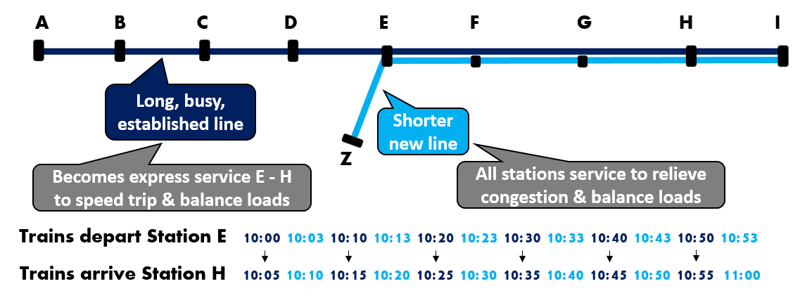
The established line is busy while the newer line is expected to be quieter. You might want both lines to run into the CBD (right of diagram) but you want to do it in a way that there isn't overcrowding on some trains while others are quiet. In other words you want to balance the loads between trains. And, because the dark blue line is long you are mindful about travel time and want express running if possible.
One option is to modify the dark blue line trains so that instead of stopping all stations they express through F and G. To retain service all trips on new light blue line would stop all stations. This spreads benefits over the whole line. For example dark blue line crowding would be less as it would no longer have two station's worth of patronage. Instead of having 7 station's worth of passengers at station H it would only have 4.7 station's worth (as some passengers from station E would board the light blue service). Meanwhile the light blue line would benefit not only new station Z but would provide less crowded conditions for people at stations F and G, for whom it would become their unique service.
The expressing would also speed travel by two minutes for dark blue line commuters. That might not seem much but the psychological effect of fewer stops makes the saving seem more. There are however capacity trade-offs as discussed later.
What about those going from the dark blue line to stations F or G which it would now skip? Passengers would need to change trains at station E. However it would be the best possible change, assuming both lines share the same platform. And it's only a three minute wait since the light blue stopper has been scheduled to depart just after the dark blue's arrival.
I have so far assumed each station has about the same walk-up patronage. However in practice it tends to be uneven. E, as a junction station may be a major centre with significant surrounding density. Because the service is frequent (12 trains per hour) people are likely to treat the service as 'turn up and go'. If that is the case then people will turn up at random times. Given this even distribution of arrivals versus the uneven train departures (with 3 and 7 minute gaps) those trains that arrive after the 7 minute gaps are likely to be more heavily loaded than those that arrive after a three minute gap. If you look at the timetable above you will see that it's the (already busier) dark blue line trains that get the higher loading. Making them 2 minutes later could ameliorate this slightly and provide an even 5 minute service. However waiting for those needing to change trains is increased from 3 to 5 minutes. If F and G aren't major destinations then this change is probably acceptable.
Capacity was mentioned before. If you look at gaps between trains in the above timetable at Station E you can see that there are 7 minute gaps around 10:07, 10:17, 10:27 etc that you could shoehorn another train in every 10 minutes. However because this gap is between a stopper and express the gap narrows to 5 minutes later. You might be able to squeeze a train into that gap but this depends on the capabilty of your safeworking and signalling systems. And there may be greater knock on effects if trains are delayed. Eventually you get to a point where the uneven gaps caused by expressing lessens train throughput capacity.

Managing capacity is a larger discussion I won't go further on. The key point is that even if a new line adds just one station (like Melbourne's airport is proposed to do) it may have wider network benefits beyond that one added station if services are scheduled carefully.
A real life example is Perth's Thornlie line, where despite adding just one station, can justify itself by allowing daytime express running on the longer and busier Armadale line Monday to Saturday (with only the limited Sunday timetable restricting its frequency and headway evenness then). Similar comments apply to Adelaide's extended Flinders line, though benefits are less due to its lower frequency than the Perth example.
If the new line has a wide spacing between stations Z and E there might be a case for an intermediate station. Especially if it fills a network hole where there's only infrequent buses or (at best) slow trams nearby. As well as the faster travel wider network benefits could include local redevelopment opportunities, relief of patronage pressure at surrounding stations, more balanced patronage between the dark and light blue lines and a logical terminus for local buses.
A station for Airport West/Keilor East
Last year the City of Moonee Valley set up the stillwaiting.com.au website to campaign for a station at where its material terms Airport West. Campaign efforts have included a petition, video advert, billboards and cinema advertising.
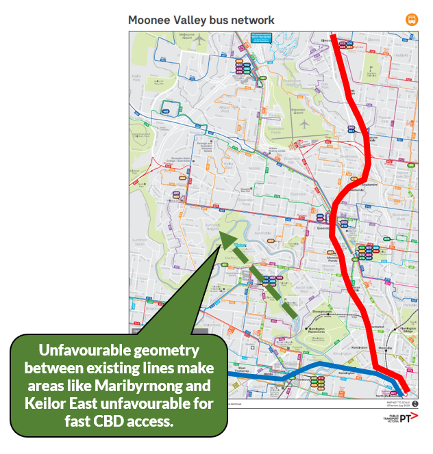
And there is little doubt that the area isn't that well served by rail compared to similarly distanced areas 15km north, east and south of the CBD. The local map below shows the geometry. There is almost 90 degrees between the line to Sunshine/Sunbury and that to Craigieburn.
The Airport West tram helps but is quite slow. And it heads north, missing a substantial area to the west near Keilor East. Buses 406 and 465 provide substantial coverage but have weak northern termini and generally inferior frequencies and operating hours compared to trams and trains. And some local trips, such as Keilor to the CBD or almost anywhere to the airport are quite slow or require multiple changes.
Similar comments apply to Highpoint Shopping Centre. It has a tram but it's the 82, which is the runt of the pack with regards to operating frequency. Traffic is clogged and the area is rapidly adding residential density. Bus services are limited and haven't been comprehensively reviewed for decades. It almost got a SmartBus but missed out when the Blue Orbital was scrapped.
Hence, amongst the many dozens of airport rail concepts, some have sought to fill the 90 degree gap with a north-western line including stations at locations like Highpoint, Keilor East and Airport West on the way to Melbourne Airport. That way the airport line would have far wider benefits than just to flyers. An extension of the special event Showgrounds line has also been suggested. You can read a history of various proposals for airport rail in this parliamentary paper.
In the end everything, including that which was supported in 2018 and funded in the 2020 state budget, keeps coming back to a Sunshine alignment. From there trains would run via the Albion - Jacana alignment before branching north around Airport West to head to the airport. No intermediate stations were included in the announced plans though in the current public consultation many have suggested one (or more).
It's something like 10km between Albion and Tullamarine. That's a long spacing between stations for a metropolitan railway, especially one that traverses a suburban residential area. Moonee Valley Council claims that a station at an intermediate point would benefit a catchment of over 25 000 residents. Hence their campaign.
Before I go further, I want to clear up a naming matter. The council describes the station site as being 'Airport West'. Which is technically true given the Keilor East / Airport West border is south of Calder Fwy and all of Roberts Rd is to the north.
However Airport West has one clear and established centre. That is the area near Westfield, the 59 tram terminus and several bus routes including the 902 SmartBus orbital. A station named Airport West would cause untold confusion given the established centre and transit hub is more than 2 kilometres away with (possibly) no public transport link between the two. Plus it might confuse some airport passengers, something to be avoided at all costs.
Instead, despite it being technically slightly outside the suburb, any new station might better be called 'Keilor East'. That would lessen confusion with the shopping centre, tram and buses. And it would be a more legible interchange with nearby buses from suburbs with names like 'Keilor Downs', 'Keilor Lodge', 'Keilor Park', 'Keilor East' and Keilor itself. Not to mention the avoidance of confusion for airport users. Its only disadvantage is that there is a Keilor Plains station on the Sunbury line. But apart from that there is no contest and I will refer to the station site as 'Keilor East' from here on.

So should we have a station at Keilor East on the Airport line as the council advocates? Yes we should. The benefits outweigh the disadvantages. The only penalty is a slightly slower trip for airport travellers. Instead of being 29 minutes it will be a little over 30 minutes. That's pretty small in the context of (a) the time people waste waiting at airports anyway, and (b) the infrequency that most people would use the airport train.
On the other hand a station at Keilor East, especially with well-connected buses, improved access over a wide area for diverse trips. Not only for CBD commuters, but also for trips to destinations including Sunshine and Melbourne Airport. Some journey times could be cut by as much as 20 or 30 minutes if not more. Plus it could provide an impetus for a more efficient bus network for reasons discussed next.
You could argue about the location though. It's highly unwalkable and doesn't strike me as being the ideal spot for a transit oriented development. Like Airport West (which already has a major shopping centre, a tram and a SmartBus) could be. On the other hand the line to the airport heads north before Airport West on the map presented so it's likely not an option without a substantial rethink.
Benefits for buses and the wider network
A major problem with the Keilor East area is that, without it having a station, there is no major local destination where buses could be terminated at. As an example key routes like the 406 and 465 have weak termini. And though they are well used the weak terminus means they have unidirectional patronage. Whereas a strong terminus would increase usage with largely the existing bus fleet as both mornings and evenings would attract more balanced bidirectional patronage via stations at both ends of the route.
One feeder bus network concept is shown below. Thicker routes are more frequent, typically 20 minutes off-peak and every 10-15 minutes peak. There will be some extra costs compared to the current network but usage with this network is likely to be higher with improved connectivity between major destinations. Click for clarity.
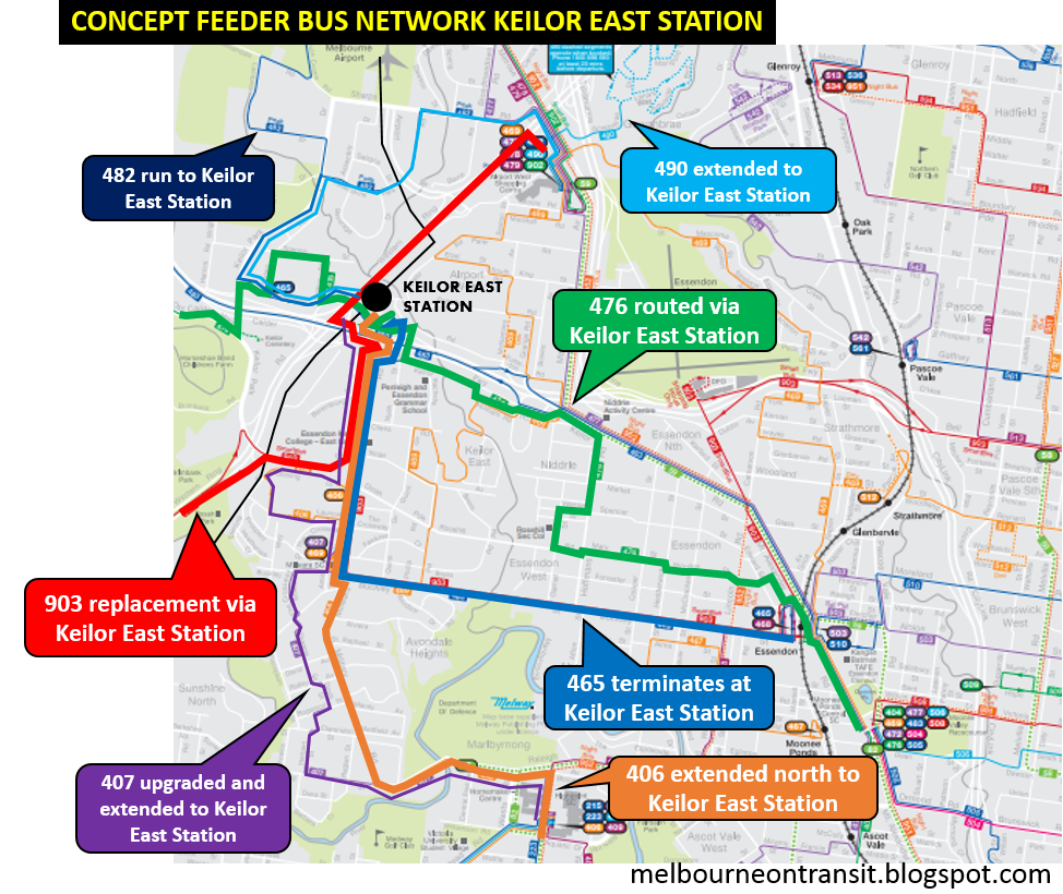
To summarise: Route 406 extends directly north to Keilor East Station to allow airport access with just one change. Route 465 provides the same facility from Buckley St. Some CBD or Sunshine passengers will prefer to ride it west rather than east for a new Keilor East station connection. Route 476 is unchanged except for it being routed via the new station. That would greatly CBD reduce travel time from Keilor and provide a good Watergardens/Keilor Downs airport connection. Potential exists to increase its peak frequency to compensate for the removal of Route 465 from Keilor East (whose residents will generally benefit from the dramatically shorter distance to their nearest station).
Some less frequent neighbourhood routes might also be extended to the new station. These include the upgraded 407 that replaces the 406 loop in parts of Keilor East. Depending on the home locations of industrial workers, the 482 industrial route might run to Keilor East Station rather than Airport West. A basic Airport West to Keilor East connection could be provided by extending the (small) 490 demand responsive route via the Sharps Rd industrial area and Keilor Park Reserve (which would gain a service) to the new station as a fixed route on that portion. Or if that's not practical potential may exist to split the new 469 at Airport West to do likewise.
If a frequent and fast connection between Airport West and Keilor East is desired that may be doable with something along the Ring Road. The problem here is the lack of intermediate stops. I've drawn in a red route that could continue west then south across the Maribyrnong to Sunshine (as per the current 903) or to St Albans to replace the 419 (which could be routed south to Sunshine to provide an eastern version of the successful 420 west of the Sunbury line). A cheaper option could be to use the 406 for this purpose (as discussed in previous weeks) for less overlapping but also reduced connectivity to the new station.
This is just one network concept. Like any other there are pros and cons. However given the number of 'dead end' bus routes in the area a new station is likely to lead to connectivity improvements. And, as I've mentioned before, a new station is often a catalyst to bus network reviews, which although they have merit in themselves, rarely happen unless there is an associated rail project.
Conclusion
One might hesitate to build a dedicated line, but given that one is going to be built for another purpose, there's a good case for a Keilor East station to serve a currently poorly served residential area within 15 km of the CBD. Benefits include improved airport and CBD access plus local connectivity improvements in an area that has a discordant mix of old and new, connected and disconnected. Just avoid confusion and don't call it Airport West!
5 comments:
Surely the best place for the station is south of the Tullamarine Freeway. It is closer to the shopping centre, more residents and importantly, PEGS, which gets its students from all over the Western Suburbs. There are a lot of students at that campus.
When I was there in the 1970s a few of my classmates travelled by rail from Werribee via North Melbourne and Essendon and then by bus to East Keilor. All up it was about 2 hours each way.
The 59 tram is dying for an upgrade. It's so close to being light rail in some sections, yet fails hopelessly due to tram stops being what feel like they're only 100m apart, even on the "light rail" part outside Essendon Airport. Never mind the sheer number of pointless road (car) crossings on Mt Alexander Rd. Also, why does the tram have to divert along the side streets like a bus instead of staying on Mt Alex Rd? Give Pascoe Vale Rd and Fletcher St to the 82 and let the 59 run direct, that would shave at least five minutes off the timetable. Probably fifteen minutes with some tram stop culling, less road crossings on Mt Alex Rd and better tram priority.
Your posts are marvellous. You clearly know your mass transit; I can only hope you have the ears of those able to effect some of the changes you advocate.
I suspect that the case for a suburban station will founder on the lack of a suitable location. It's basically factories and light industrial from Albion to Airport West.
The junction of Fullerton Rd and the Western Ring Rd, or Airport West shopping centre, are the only plausible candidates - but each comes with its issues.
The idea of routing the 903 via the junction works fine as a Texta scrawl on a map, but the reality of complex road interchanges isn't favourable. Getting a peak-hour bus from the west side of the Ring Rd to a station on Roberts Rd, then back onto the west side of the Ring Rd and finally into the shopping centre would be a costly timetable feat. Even via the back-streets, you'd be looking at 10 minutes - plus dwell time - for barely 3 km.
Thanks George. Yes, it's a difficult trip. And, with a fast, frequent train to Sunshine, it's arguably not even necessary. A cheaper option with fewer km could just be to route 406 to Sunshine. That could replace the 903 which could instead go via Highpoint. And as 406 is well used it could be made a SmartBus. The main trade-off for that is that Avondale Hts, Highpoint & VU loses a direct bus to the new station. On the other hand all are accessible to Footscray, and although it's geometrically indirect a change to the airport line can be made there.
Although it will be a slow trip, I think some bus connection between Airport West and Keilor East Station is desirable. Not because many people would necessarily travel between the two but because there are about the strongest local anchors for routes going via (say) the industrial area. But if we had a prediliction for big spending on busways and surmounting what lies between, then a BRT style service between Glenroy, Airport West SC, Keilor East Station, Keilor, Keilor Plains Station, Taylors Rd and then out to Caroline Springs Town Centre or even Rockbank could be grand and good.
Unfortunately the location of the new East keilor station will be it's downfall. It's in the middle of nowhere. You either have to bus it or drive there. So getting to the city from East keilor and Avondale Heights will take longer than just going to Essendon station. They should have just gone from the showgrounds to highpoint to Milleara mall and airport west shopping centre then onto the Airport. It would have been more direct, served more people and would have taken less than 30 mins from the city to airport
Post a Comment