Tuesday, February 09, 2021

Timetable Tuesday #104: 28 February 2021 bus recoordination

 Timetables for the second tranche of bus recoordinations are now out. Starting on February 28, the new times are intended to restore coordination with trains whose revised timetables started on 31 January. 

I covered the first round of bus changes three weeks ago. Today I'll talk briefly about the second round. These are listed by PTV here

Nearly 50 metropolitan and 70 regional city bus timetables are changing on the 28th. I'll discuss a few of interest today. 

Ballarat's broken harmonisation

Although my focus is metropolitan Melbourne I thought I'd first look at Ballarat timetable harmonisation. This is because their off-peak trains have improved from hourly to 40 minutes on weekdays. This means that their buses, at 30 and 60 minute headways would have to change to every 20 or 40 minutes maintain coordination.

Did they? 

I looked at a few routes. 

Route 10 every 60 min to every 60 min

Route 11 every 30 min to every 30 min

Route 12 every 30 min to every 30 min

Route 13 every 60 min to every 60 min

Route 14 every 30 min to every 30 min

Route 20 every 60 min to every 60 min

That's not all of them but it's enough of a sample to conclude they haven't headway harmonised buses with trains off-peak. Though there have been minor time adjustments, presumably to better meet peak trains. Although there remains the problem of early evening finishes with down trains not met by buses, especially on weekends.

Does this matter? Ballarat's distance (or more precisely travel time) from Mebourne means that there might not be that many who'd take (say) a midday bus then change to a Melbourne-bound train. Although it's not implausible they may wish to do so for some closer in trips. A bus every 60 minutes meeting a train every 40 minutes means recurring connections every 2 hours, that is just one in every three trains off-peak. 

As I mentioned last month, the Department of Transport has oversold these bus recoordinations. But whereas last time timetables that were unharmonised before were not harmonised afterwards, in this case bus timetables harmonised before have been unharmonised with this change. This will mean passengers attempting bus - train trips will need to more carefully plan their trips and potentially face longer or at least less consistent waiting times if they don't have much discretion over when they travel. 


The reformed 512 - Now on the Useful Network (sort of) 

Just over a year ago I profiled Route 512 through the back streets of Coburg.  Its timetable could have harmonised with trains every 20 minutes but it didn't. The reason? Some trips did a deviation through Coonans Hill that took extra time. The result was a timetable that had some 25 minute gaps. Thus there weren't consistent connections with trains nor memory 'clockface' times. 

Apparently the deviation was not well used, with this fact known by people in the Department of Transport. This timetable change quietly drops it, provides an even harmonised 20 minute frequency and even slightly extends Saturday service so it finishes just after instead of just before lunch. This is the stuff that 'smell of oily rag' bus network reform is made of. 

Researching this item required resort to the abovelinked post and memory. Why? When bus routes have complex deviations the Department of Transport frequently trips up when it comes to communicating their services accurately on the PTV website. 

DoT's automated systems may work when every trip goes the same way, but when they don't then  painstaking manual checking by people who know every deviation of every route is required. When that doesn't happen, or systems are slow to update any manually entered corrections then information presented is wrong and the travelling public gets misled.  

The 512 example below is where if you wanted to look up a trip for today you would enter the route number and select the 'until 27-02-2021' link. However the timetable under that will contain only a few trips, those that do the deviation. 80% of the route's trips won't be there. You'll only find them if you select the later date (despite you travelling before then!) and digging for a timetable (that shouldn't be there) for the earlier period. That timetable has the missing trips but needs to be read in conjunction with the trips with the deviation to see all trips. (click for better view below)


Fortunately, that problem is only temporary. The bigger picture is the improvement coming in just over two weeks. The map below shows the improved consistency and directness (which enables the consistent 20 min weekday service). 


The Saturday service becomes a flat 40 minute frequency for most of the time that it runs. The 512 is one of those routes that hasn't had a serious timetable revamp for 30 plus years. Hence it reflects past retail trading hours, such as midday Saturday shop closing. 

This new Saturday timetable improves things here. But only by a little. Instead of having to skedaddle before lunch (last bus 12:10pm Strathmore, 12:35pm East Coburg), one can now linger until 1:15 and 1:45pm respectively. A small but welcome span improvement. I haven't tallied the service kilometres added but it might break even with that which was saved by removing the deviation. 

The extra 65-70 minutes span illustrates the difficulty of bus service upgrades in Melbourne. At the current rate of service growth we are more likely to have Airport Rail operating in 2029 before the 512 (or many other busier higher priority routes) get their next lot of service increases. 

Recoordination in Werribee

A major change was the improvement of the Williamstown, Altona and Werribee trains to operate every 20, 20 and 10 minutes (respectively) in peak. As opposed to harder to remember 22, 22 and 11 minute frequencies with some extras thrown in for Werribee. 

There are not many buses that feed (as opposed to parallel) trains for Altona and Williamstown. But there are many bus feeders at stations like Werribee, Hoppers Crossing and Williams Landing. It is understood that services are tightly and efficiently scheduled. This means that if train frequencies improve then bus frequencies would also need to improve. Even if it's only one or two minutes here and there the knock on effect may require more buses to be bought to maintain good timetables without too many peak period 'holes'. Especially given the area's continued growth and increased post-COVID traffic volumes. 

Unfortunately it looks like this recoordination was done on the cheap. The result is that gaps between buses can be longer during peak times than off-peak, especially if run times are lengthened. I didn't look at all timetables but a peak-of-peak 28 minute gap for Route 180 (which is nominally every 20 minutes) towards Werribee stood out. 


Route 180's fate is the sort of 'death of a thousand cuts' atrophy that Melbourne bus services often experience, as travel times deteriorate due to rising car traffic. It's also worth noting that Route 180 is one of Melbourne's highest performing bus routes in terms of patronage per service kilometre and need for improvement. 

A kludge that's outlived its usefulness

Not that it's been fully implemented network-wide, but the minimum service standard for buses in metropolitan Melbourne is one bus per hour (introduced 15 years ago in 2006 - more here). 

There are times though when the 'least worst' outcome is to stretch that. For example where trains run every 40 minutes, such as is common on Sunday mornings, a bus every 60 minutes won't connect evenly with them. And it is known that many people wish to travel on Sunday mornings before the 9am start stipulated in the minimum standard. You can tell that if data indicates that the first Sunday trip is busier than any other that day. 

A cost-effective solution to both problems can be to permit an 80 minute gap between buses early on Sundays. If timed well this can permit even connections with trains and improved span with the same number of trips. And the inferior frequency is possibly more tolerable when in most cases the bus is the first public transport trip people take that day so they can more easily plan when to leave home.  

Hence, if you look at bus timetables like the current one for Route 498 there is approximately an 80 minute gap between the first two trips. Then there might be a 40 minute gap (uneven but harmonises with trains). Once trains have gone to their 20 minute service the buses can then go to their usual hourly headway with connections to trains maintained. 

One of the major improvements in the 31 January train timetables was to boost the Werribee line's Sunday morning frequency from every 40 to every 20 minutes. This higher frequency means that buses can run hourly from first trip and still harmonise with trains (in the to city direction).  However Route 498's new Sunday timetable, with its uneven 80/40/60 minute frequency continues to reflect a pattern that was necessary with the old train timetable, not the new one.  

Conclusion

No doubt many more stories could be told about the revised, apparently coordinated, bus timetables starting later this month. However those reviewed give a taste of what was done. It's been a very bare bones 'quick and dirty' exercise that leaves several ends loose, including harmonisation in Ballarat and even peak frequencies in Werribee. The next, and final, tranche of bus timetable changes (including for Melton) will be announced in several weeks. No doubt the topic of a future post here.  In the meantime if you have comments on these timetables, including some I didn't look at, please leave them below. 


See all Timetable Tuesday items here

Friday, February 05, 2021

Building Melbourne's Useful Network Part 80: Boroondara's 'Busless Five'

Boroondara contains some of Melbourne's richest suburbs. It's basically wide treed streets, private schools, mums with 4 wheel drives and established well-off older people. Except for schoolkids not many use buses. Partly because there is no longer much of a regular bus network. 

Boroondara was old enough to get trains and trams but new enough to have significant gaps between them. These were filled by private bus operators running their own routes from the 1920s onwards. Some paralleled trains and trams to run into the CBD. 

WWII restrictions including fuel rationing removed or shortened a lot of bus routes that were considered duplicative because they ran into the city, parallelling trains and trams. Then, after the war, suburbs like Kew or Camberwell were rich enough for its residents to be among the first to take up driving in large numbers. Without government subsidy up to the early 1970s, that killed off many bus routes. Bus operators found better pickings in areas with lower car ownership or developing outer suburbs with no trams or trains at all.

Camberwell's dominance might also have stymied alternative local centres; there's huge areas of Kew and Balwyn without much more than a milkbar within short walking distance. The road network also tends to funnel people to Camberwell and Kew with additional oblique roads providing more directness to these centres compared to if there was just the north-south east-west grid.

The relative sparsity of medium sized centres (eg those with at least a supermarket) compares with much higher densities of everyday retail in areas like Brunswick or even in the south-east like around Carnegie or Bentleigh. The early spread of motorised public transport (feeding into Kew and Camberwell) and then private transport would not have helped here. The lack of medium sized centres also affects whether you'd bother running a bus to them, as I'll discuss later. 

You can compare Boroondara's bus network with Brunswick by looking at these 1971 network maps. Both areas had radial trains and trams but more working-class Brunswick (which was still low car ownership then) also had closely spaced cross-radial bus routes. Boroondara buses by then were sparse, making trips to places the trams missed indirect or inconvenient. That remains today and there are several main roads without buses.   

Brunswick eventually got its buses cut, perhaps two decades later. But its network remains denser than in Hawthorn/Kew/Camberwell. Even its Hope Street bus remains today in modified form. Brunswick's main problem with buses is that key routes like the popular 506 missed out on 'minimum standards upgrades' that buses in other part of Melbourne got. 

For a while populations in Melbourne's affluent inner-east aged and declined. However the area remained attractive for high income professionals. Especially those with children since the area contains Melbourne's most prestigious schools. And as old houses were sold, demolished and turned into units population densities started rising again. As has the number of cars, if a house with one or two cars was replaced with (say) four townhouses with six cars. 

It's common for locals to say they want to keep their area's treed green image but complain about 'lack of parking'. The latter is really a consequence of their own propensity to drive and the lack of good transport alternatives for many trips. Along with a resistance to paying for it, despite a willingness to pay for convenience or prestige in other parts of their life and a higher means to do so than most other Australians. 

Which gets us onto public transport as the area's demographics change from low trip generating seniors rattling around in houses towards more frequently travelling younger (often renting) professionals in townhouses and apartments. 

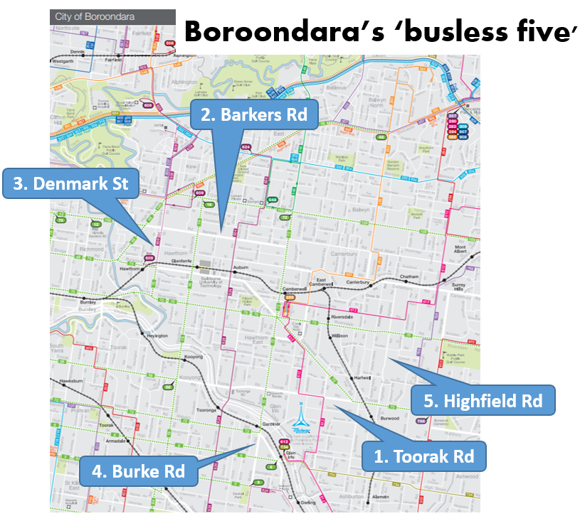
Today I'll look through some of Boroondara's key roads that lack buses. I've called them the 'busless five'. I'll discuss where a possible route might go and its prospects for patronage. 


1. Toorak Rd 

This is a key east-west road that has a tram along its western and eastern part but no bus in the middle. This is due to a network topology that sucks everything in towards Glenferrie/Camberwell. The historical lack of large destinations along parts of that corridor wouldn't have helped either.  

The Glen Waverley train line in the area runs south-east while buses are north-south. This opens up a large gap where a simple east-west trip is not possible without substantial backtracking and changing. The lack of a bus also reduces connectivity to destinations such as Deakin University, the poorly served Coles headquarters and Stocklands Tooronga. 

While a Toorak Rd bus route could make sense and connect many other routes in the area, a problem exists as to where it should terminate. This is unlike Canterbury Rd, which I discussed here, where the best termini are clearly Ringwood and Box Hill. 

Possible western termini are either weak or they involve signifificant extra route kilometres. An example of a weak terminus is a station like Kooyong where there are few other major destinations nearby. Hence it is only useful for trips involving a change to a train. Similar can be said for the Route 58 tram terminus where it's a slow trip into town or a double transfer to a train at South Yarra. 

Other options include a northward terminus at Swinburne University/Glenferrie or a southward terminus at Malvern Station. Both involve significant overlap with trams with the latter missing a Glen Waverley line station. 

The cheapest eastern terminus could be near Burwood Station. That would provide connections to the 75 tram and the Alamein train (though that often involves a connection at Camberwell). Like on the western side there are few really major termination points that (i) would attract high passenger volumes or (ii) do overlap with other routes, notably Warrigal Rd.

A low cost possibility could be to form this route by extending the 766, which would provide a connection to Box Hill which should provide a strong terminus, especially if 766 was straightened (which it could be if reformed in conjunction with the construction of the new Surrey Hills Station). A further option could be merging with a Highfield Rd bus discussed later. 

As for service levels it might justify being a good local route with some extra peak frequency if the route option chosen feeds a nearby station like Kooyong. But I can't see it being strong enough to be the sort of premium frequency and long hours routes that I'd recommend elsewhere.

2. Barkers Rd

This is an east-west street with no buses. It is half way between the parallel 109 tram and the Belgrave/Lilydale railway. Hence it has little  unique coverage if you assume people will walk 800 metres to a high quality service. But there are several schools so there is potential for significant traffic at school times. 

The most obvious route seems to be from Victoria Gardens to Camberwell. You might wish to run it further to Burnley Station via Burnley St but that is probably better part of its own north-south route. Hawthorn Station is another possibility but the geometry is poor for it to work as a serious train feeder.  

As for its eastern terminus, there may be potential to extend it east to Box Hill via Mont Albert Rd which is also busless. However it would contribute no unique coverage as Mont Albert Rd, the 109 tram and the Ringwood train get increasingly close as you head east. 

Unless there is substantial population densification in the area, I'm not sure that this route would have a particularly high patronage potential for anything but a local level of service. Introducing it would not be a high priority unless it could be shown as cost-effective in conjunction with reform of school buses in the area. 

3. Denmark St/Power St 

Strictly speaking it's not unbussed, but with only a couple of trips on the Route 609 operating, it might as well be. A much better service than that has a lot going for it. It would connect the busy Kew junction (served by numerous but slow trams) with the faster train at Hawthorn (just four stops into the city).  And it would fill a connectivity gap. 

Hawthorn has a good train service (better if upgraded to every 10 minutes already happens on weekends and is cheap to do on weekdays) but is a bit of weak terminus. You could argue that a short extension to Swinburne Uni at Glenferrie would make it stronger. 

And in the north an extension via Chandler Hwy to say Fairfield could connect the Alphington development into rail. It could even be joined with the 567 to extend as far as Northland or even La Trobe University as discussed here

This makes it a far cry from being a very short Denmark St route. However the expanded route possibly has more prospects than most other links discussed here. Therefore it might justify at least a Useful Network level of service. 

4. Burke Rd 

The part in Boroondara has a tram. But the part to the south has neither a tram nor bus. This represents a major break in the network with Caulfield only a few kilometres to the south. While traditionally not considered much of a destination for the eastern suburbs, it now has a Monash campus nearby. Also in its favour is the Metro tunnel and airport rail which will serve the station. 

Personally I think there's enough density and likely need for both Tooronga and Burke Rd to have a bus. Ideally these should be fairly long north-south routes. But if you wanted to provide some non-duplicative service quickly you'd extend Route 734 to Caulfield via Gardiner and Burke Rd. This, and an upgrade for Tooronga Rd, is discussed here. They are likely more cost-effective network reforms than others discussed here. Longer term though a Caulfield - Camberwell tram would plug a major gap between the east and south-east including about half of Melbourne's railway lines. 

5. Highfield Rd 

When you zoom out you think it ought to have a bus. It's a long way from it to the parallel Alamein railway to the west and the parallel Warrigal Rd to the east. A short version of a Highfield Rd route might run from Burwood Station to the new Surrey Hills Station.

But neither of these are big attractions that would generate much all-day non commuter patronage. The Surrey Hills end might extend to Box Hill. It's less clear what you might do in the south. Potentially it could run via Summerhill Rd to Ashburton but that's not very strong either. Chadstone via Holmesglen is possibly the strongest alignment although Caulfield wouldn't be much further. 

This would be one of the weaker routes presented today. Especially since there are some coverage overlaps with the 612 and 766. It would probably only ever be a less frequent neighbourhood style route. But it might be considered in conjunction with wider area bus network reforms. 

Conclusion

What are your thoughts on the above bus concepts? Are there others I've missed? Or do you think they should be considered less important than other areas with populations known to have higher propensity to use buses. Comments are appreciated and can be left below. 

See other Building Melbourne's Useful Network items here


Tuesday, February 02, 2021

Timetable Tuesday #103: Implementation of the 31 January 2021 train timetable - Frankston line

Few words this week as I've got a video instead. Made on the first day of the new timetable it is mainly about passenger information provided. As you'll see there's some hits and some misses. 

Later in the video is footage of works being done around Chelsea station in preparation for the level crossing removals in the area. 


See all Timetable Tuesday items here