Last week Melbourne University's John Stone and Iain Lawrie proposed a 'Clean Slate' frequent bus grid for Melbourne's west. This, and earlier RMIT work from 2020, was based on Paul Mees' 'Squaresville' concept from Toronto. The authors envisage it as a thought experiment to show the potential accessibility gains from a grid style bus network in western Melbourne. Then on Tuesday the Victorian Greens proposed a grid network of electric buses without details of routes or frequencies.
Last Friday I mentioned the power of maps, with particular reference to the freeway maps in the 1969 Melbourne Transportation Plan and, more recently, the Suburban Rail Loop. More than words they communicate visions and raise expectations. Maps that resonate can even make money appear.
2021's Victoria's Bus Plan correctly identified many issues with buses. But, like the Greens' plan, it lacked maps. The previous plan of substance, 2006's Meeting our Transport Challenges did have maps. One map showed existing and planned SmartBus routes up to Stage 3 while another identified 'Principal Public Transport Network' corridors in a Stage 4.
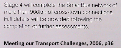
State government planners in 2006 envisaged that a complete SmartBus network would have more than 900km of cross-town connections, with Minister Kosky reaffirming this in 2008. On Sunday I used their PPTN map to make a list of potential routes in such an enhanced SmartBus network.
How does that 900km network compare with what runs now? Out of today's 350-odd bus routes eight of them (900, 901, 902, 903, 905, 906, 907, 908) are SmartBus; a number that hasn't changed in over a decade. To this should be added five non-SmartBus routes (216, 220, 223, 234, 246) that offer SmartBus equivalent service. Parts of 200/207, 250/251, 302/304 and 732 also qualify. All up it's 485km worth of SmartBus-type service on 17 route corridors. Route 703 was a SmartBus pilot but never gained full SmartBus operating hours so is excluded from the total.
SmartBus refreshed: Welcome to the Future Frequent Network!
First-cut 'Squaresville' networks are just lines for academics' projections. Some lines traverse sparsely populated areas while others fail to efficiently connect people with where they want to go. Modified refined 'Squaresville' networks are more practical, working well in continuously settled cities with grid road networks including Toronto and much of Melbourne.
The 2006 PPTN was more allied to activity centres but routes weren't clear. Besides it was drawn 16 years ago. Melbourne has added over a million people since. Therefore it's high time for a 2022 version. Especially with an election coming up and various parties preparing their pre-election pitches.
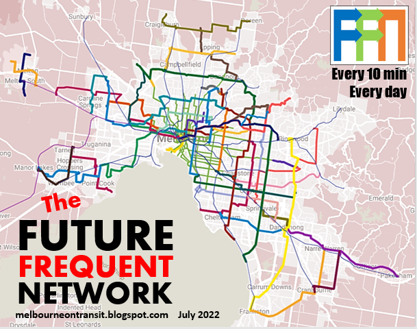
I've called it the 'Future Frequent Network'. And, heeding my advice, there will be a map!
How many route kilometres would the FFN have? 2006 planners aimed for 'over 900 kilometres'. Today 1200km would not be unreasonable, given subsequent population growth. But there's a catch.
Melbourne's SmartBus' service levels compare poorly with top tier bus routes in Sydney, Brisbane and Perth. This is mostly due to their 30 minute weekend frequencies. Other issues include evening frequencies and the 9pm Sunday finish on most routes. 15 minute weekday waits, even in peak, are also not ideal for major routes in a big city and do not constitute 'turn up and go'.
Consequently I will recommend a smaller but more frequent network of around 950km. As many as possible routes would run every 10 minutes or better during the day (7 days) with 20 minute maximum waits at night. However many areas away from the Future Frequent Network could still gain through improved local services with a 7-day 'Useful Network' operating every 20 minutes or better over long hours.
Without more words, here's the Future Frequent Network, presented as an interactive map. Click top right to enlarge and click left to show or hide various layers by mode and frequency.
Want to compare this with the service your area currently gets? See the Melbourne Frequent Network Maps for existing service levels by day of the week. The improvements in many areas are massive! Prefer a fixed map? Just scroll right to the bottom.
Notes
* Most bus routes will be familiar but some are made longer or shorter. Others are new or changed to provide improved directness and frequency to more people and places. The number of bus route corridors with frequent service almost triples from 17 to 45. While the total kilometres involved doubles from 485 to 963km (excluding the weekday-only university shuttles).
* Thick lines are Future Frequent Network routes. Thin lines are notional Useful Network routes typically every 20 minutes or better. Again some are existing while others are new or reformed. Click on the line for more information.
* Complementary train and tram timetable reform is desirable to better connect with buses and make the Future Frequent Network truly multimodal. The main components of these include 'greenfield' Metro train timetables to upgrade frequencies to 10 minutes day/20 minutes night and tram network reform to boost widespread 12-15 minute frequencies to 10 minutes. Since it got upgraded in 2021 the Frankston line timetable sets a desirable template for trains.
* New train stations at Paisley and Campbellfield would enhance network connectivity in areas where the grid is coarse or broken. Other than that no rail or tram extensions are assumed, although the FFN will maximise benefits from 'Big Build' projects. Bus, workforce, depot, interchange requirements, and other matters will need assessment as part of planning. As will some exact route alignments and choices for the FFN.
* Roll-out can be done in stages over a multi-year program (say 5 to 8 years). Significant parts (eg getting to 15-20 min maximum waits) can be done without additional bus purchases - only more funded drivers and service kilometres. Widespread roll-out of 10 minute frequencies will however require more buses as will local route upgrades, especially in growth areas.
* The 2022 Victorian State budget allocated $847.5m for 129.3 million bus service kilometres in metroplitan Melbourne BP3, p335). A 25% increase in annual bus service kilometres (proportionally similar to that delivered under 'Meeting our Transport Challenges' between 2006 and 2011) could deliver a large proportion of the Future Frequent Network. This would represent a fair catch-up as we haven't had a new SmartBus route in over a decade and we have grown by over a million people since.
Many winners across Melbourne
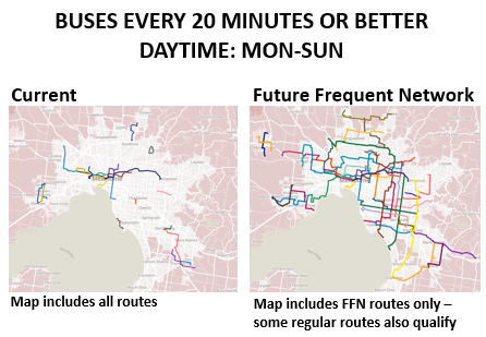
On a gains per dollar basis few public transport projects would exceed that provided by a Future Frequent Network like that described above. It will vastly improve 7-day mobility across and around Melbourne. The map below gives a snapshot of the big uplift in 7 day service every 20 minutes or better on key routes. The extent of service every 10 minutes or better would rise by an even greater amount.
FFN would maximise or bring forward benefits from State Government 'Big Build' projects such as level crossing removals, the Metro Tunnel, Airport Rail and the Suburban Rail Loop. Particular examples include the Sunshine - Melbourne Airport bus and the SRL SmartBus between Box Hill and Southland/Sandringham.
The Future Frequent Network would be a step change for public transport in outer Melbourne, especially if train frequencies are also improved. Currently just three SmartBus (or equivalent) bus routes run outside the M80 or east of Stud Rd. The FFN boosts that to over 20.
The above map concentrates on the route and service aspects of an upgraded bus network. However targeted infrastructure investments such as bus wormholes would speed travel in key locations. There are also large growth areas distant from rail. Potential may exist for busways to provide rapid transit in these parts. Potential corridors could include Taylors Rd, Wollert and Clyde Rd. The FFN adds frequent routes on these corridors (routes 418, 360 and 899 respectively) to assess potential demand that could justify larger works.
Route summary (long: feel free to skip)
The following list potential Future Frequent Network routes. Most existing SmartBus corridors are included plus many more. Routes in green already have high service and need relatively few (if any) additional resources. Those in yellow need significant extra hours with existing buses for better span and frequency. Those in pink need both hours and extra buses. All but university shuttles would operate 7 days per week until midnight with frequent service.
150 Tarneit - Williams Landing - Point Cook South 20km A joining of existing 150 and 497 to give a north-south through route. Improved in frequency due to high patronage and large catchment in Truganina area. A cut down version could just operate as the existing 150 (10km).
165 Manor Lakes - Werribee Plaza - Hoppers Crossing - Point Cook - Laverton 25km East-west route incorporating existing 166 and 498. Fills need for legible east-west connections from Point Cook.
170 Tarneit - Werribee Plaza - Werribee - Wyndham Vale 16km Joining of existing 170 and 190 at Werribee and boosted frequency and hours. Joins major centres and train stations in Wyndham with more frequent service.
201 Box Hill - Deakin University 5km Existing unchanged shuttle. Upgrade funded in 2022 state budget. Some background here.
200/207 Kew - City 13km Unchanged existing route pair with frequent service on combined section.
216 Sunshine - Melbourne 13km Unchanged existing route with already frequent service.
220 Sunshine - Melbourne 15km Existing route with already frequent service. Straightened to run along more of Ballarat Rd in conjunction with reform to Route 410. Potential future Megabus or light rail corridor.
234 Garden City - Melbourne 7km Unchanged existing route with already frequent service.
246 Clifton Hill - Elsternwick 13km Unchanged existing route with already frequent service.
250/251 Northcote - City 11km Unchanged route pair with frequent service on combined section. Minor increases in operating hours.
301 Reservoir - La Trobe University - Macleod 7km Existing weekday only shuttle extended to Macleod to provide a fast connection to La Trobe University from two rail lines.
302/304 Mont Albert North - City. Unchanged existing route pair with frequent service on combined section. Minor increases in operating hours needed.
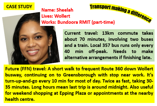
360 Wollert - Epping - Greensborough 20km NEW Fast route providing fast and direct service in Wollert area. Replaces portion of 566 and 901 between Epping area and Greensborough.
375 Airport West - Broadmeadows - Roxburgh Park - South Morang 28km Replaces Airport West portion of 902 orbital and northern part of 901 orbital.
390 Craigieburn North - Craigieburn - Doreen 28km Existing route with extensions for more residential catchment and upgraded frequency/hours.
401 North Melbourne - Melbourne University - Victoria Park 6km Extended to Victoria Park incorporating Route 202 to provide east-west connection every 10 minutes. Currently weekday only but consider need for weekend service.
402 Footscray - East Melbourne 8km Existing unchanged route with upgraded hours and evening / weekend frequency. Intersects with many north-south trams with high use for local trips. Potential extension to Jolimont or Parliament.
406 Footscray - Highpoint - St Albans 21km Existing popular route made more direct in Maribyrnong area and extended to St Albans with local route reforms to retain coverage. Improved frequency and hours especially Footscray - Highpoint. Done in conjunction with Essendon - Highpoint - Sunshine SmartBus rerouting (see 904 below). More detail here.
411 Footscray - Altona North - Laverton 24km Existing route greatly upgraded in service to operate as replacement for the Millers Rd 903 SmartBus with a strong connection to Footscray and improved service in Altona North. Introduced in conjunction with reforms to local routes. Would connect to a rebuilt Paisley station, improving local connectivity. Background here.
418 Rockbank - Caroline Springs - St Albans 19km Existing route extended west along Taylors Rd to serve Aintree with a high quality service. This route is Stage 1 for Taylors Rd to be a potential North West Bus Rapid Transit corridor. Ultimately it could feature multiple frequent routes one of which may extend east to a potential Keilor East station on the Airport line.
420 Sunshine - Deer Park - Watergardens 16km Existing unchanged route with upgraded hours and frequency. Has significant unique coverage and strong demographics that would value improved services. Also strong feeder for emerging Deer Park transport hub.
450 Weir Views - Melton Station - Woodgrove Shopping Centre - Coburns Rd - Kurunjang 12km New route to deliver frequent and direct service in area. Introduced in conjunction with Melton town network review. Current bus services in Melton are infrequent and indirect.
455 Cobblebank Station - High St - Woodgrove Shopping Centre - Bulmans Rd - Melton West 12km New route to deliver frequent and direct service in area. Introduced in conjunction with Melton town network review. Current bus services in Melton are infrequent and indirect.
460 Watergardens - Caroline Springs Station 12km Existing unchanged route with upgraded hours and frequency. Significant unique catchment with many destinations strung out along it.
500 Sunshine - Melbourne Airport 16km New limited stop route to provide Sunshine - Melbourne Airport connectivity as precursor to Airport rail. Good frequency with long operating hours. More on the concept here.
508 Footscray - Moonee Ponds - Alphington 17km Existing route with optional joining with Route 404 to Footscray for enhanced east-west service across inner-north. Improved hours and frequency.
550 La Trobe University - Heidelberg - Burke Rd - Camberwell - Caulfield 19km New route to provide much needed north-south connection that joins half Melbourne's train lines, tram lines, universities etc. Currently a major gap in the network filled only by infrequent 548 and 624 routes. Major feeder to Metro Tunnel and Airport Rail. A high priority but exact alignment subject to evaluation (an alternative would skip Camberwell but be nearer to Swinburne).
560 La Trobe University - Northland - Albert St - Fairfield - Chandler Hwy - Kew - Hawthorn 16km New route incorporating much of existing 567 and 609 to provide needed north-south connection including service to dense apartments at Alphington. Scope to extend to Swinburne University.
601 Huntingdale - Monash University 3km Existing unchanged weekday only shuttle.
630 Elsternwick - Gardenvale - Ormond - North Rd - Huntingdale - Monash University 16km Existing popular route slightly extended for stronger terminus at Elsternwick. Potential further extension to Port Melbourne via 606 alignment. Already high peak frequency but needs longer operating hours and better off-peak frequency.
693 Chadstone - Oakleigh - Ferntree Gully Rd - Mountain Gate - Ferntree Gully 24km Existing direct route extended west to Chadstone but shortened to terminate at Ferntree Gully. Cost reduced as the boosted frequency on this route would replace the mostly overlapping 742 between Chadstone and Monash University and parts of the 753 in the Knox area. Background on a similar concept.
703 Brighton - Bentleigh - Centre Rd - Clayton - Monash University - Blackburn Rd - Blackburn Station - The Pines 36km Existing Brighton - Blackburn 703 SmartBus but extended north to provide a strong north-south connection including a train feeder and Monash/SRL access. Can be rolled out in two stages with first priority being more regular scheduling and operating hours extensions for the existing Brighton - Blackburn portion. Scope for improved directness in Blackburn South with a Canterbury Rd route replacing the Forest Hill Chase deviation.
732 Vermont South - Knox City transit link 6km Existing unchanged shuttle that already operates frequently over long hours. This is part of the longer Box Hill - Ferntree Gully 732 whose role and service level may be considered in a future local network review.
733 Box Hill - Middleborough Rd - Mt Waverley - Stephensons Rd - Monash University - Clayton - Clarinda - Southland - Sandringham 30km The existing 733 but extended south from Clayton to Southland / Sandringham. A very popular route that most closely replicates the Suburban Rail Loop between Box Hill and Clayton. This 'SRL SmartBus' extension would make it even more like the SRL. Government has funded some upgrades in the 2022 budget recognising its high usage that exceeds current service levels (every 30 - 60 min most times). Some background here.
737 Westall - Monash Clayton - Blackburn Rd - Glen Waverley - High St Rd - Knox City - Boronia - Bayswater North - Croydon 36km The existing 737 but with an optional extension to Westall Station to serve high density in area. Upgrade would simplify route and provide a frequent Glen Waverley - Knox area connection as well as improving service to a large area east of Ringwood.
791 Frankston - Langwarrin - Cranbourne - Cranbourne Rd - Narre Warren - Fountain Gate 29km A joining of existing 791 and part of 841 to create an outer circumferential route to link major destinations in the cities of Frankston and Casey. Would serve a large catchment as the current network has no SmartBus services in the large area east of Dandenong - Frankston Rd.
810 Monash University - Mulgrave - Springvale - Noble Park - Heatherton Rd - Dandenong North - Dandenong 16km A new route that would replace existing infrequent 811 on Heatherton Rd with an upgraded service to beenfit a high social needs catchment. Would provide a feeder for the Monash precinct/SRL and add capacity on the busy Springvale Rd corridor. More here.
820 Clayton - Centre Rd - Police Rd - Waverley Gardens - Jacksons Rd - Noble Park 13km A new route that replaces part of infrequent existing routes 631 and 814. Feeds SRL interchange at Clayton and extends frequent service to a large poorly served catchment.
828 Southland - Cheltenham - Keysborough - Dandenong 17km Unchanged central portion of existing Route 828. Option to extend west to Sandringham in place of 733 (see above) and/or operate to Fountain Gate or existing terminus of Berwick subject to further analysis (see 830 below).
830 Dandenong - Doveton - Fountain Gate - Berwick - Princes Hwy - Pakenham 31km Incorporates eastern part of existing 828 and most of existing 926 to provide a frequent direct highway route service many destinations. Exact starting and finishing points subject to further analysis (see 828 above).
899 Berwick - Clyde Rd - Linsell Bvd - Cranbourne 15km Extension of existing 899 route incorporating existing 798 to provide a new frequent and direct Berwick - Cranbourne link. Serves major growth area remote from train services.
900 Caulfield - Chadstone - Oakleigh - Huntingdale - Monash - Wellington Rd - Rowville 23km Unchanged existing SmartBus route with already frequent weekday service. Particularly needs weekend service upgraded to every 15 min or better in recognition of high usage around Chadstone.
901 Frankston - Dandenong - Stud Rd - Knox City - Ringwood 46km Existing SmartBus orbital but shortened with sections replaced by other routes in north-east and north (see proposed frequent routes 360, 375, 703 & 902). This is necessary because parts of the existing 901 overlap other routes, are indirect or are poorly used. Evening and weekend maximum waits would be reduced from 30 to 20 min.
902 Chelsea - Edithvale Rd - Springvale - Glen Waverley - Nunawading - Doncaster - Greensborough - Keon Park - Broadmeadows - Melbourne Airport 76km Existing SmartBus orbital but with direct Doncaster Shoppingtown - Greensborough connection. Swapped with SmartBus 901 (375 on map) to run to Melbourne Airport. Evening and weekend maximum waits would be reduced from 30 to 20 min.
903 Mordialloc - Mentone - Warrigal Rd - Oakleigh - Chadstone - Holmesglen - Deakin Uni - Box Hill - Doncaster - Heidelberg - La Trobe Uni 43km Route split at Heidelberg to allow optional extension to La Trobe University and 904 (below). Evening and weekend maximum waits would be reduced from 30 to 20 min.
904 Heidelberg - Northland - Coburg - Essendon - Highpoint - Sunshine 30km Formed from split 903 orbital to improve punctuality. Amalgamated with shortened 527 to provide increased frequency at least between Coburg and Heidelberg. While Altona North - Altona portion replaced by upgraded 411 with improved connections to Footscray and Altona Meadows (see above).
905 The Pines - City 25km Unchanged existing route with already frequent service and long hours.
906 Warrandyte - City 34km Unchanged existing route with already frequent service and long hours.
907 Mitcham - City 27km Unchanged existing route with already frequent service. Boost service to operate every 10 min during day, 20 min at night due to high usage.
908 The Pines - Doncaster Park & Ride 9km Unchanged existing SmarBus route with already frequent service and long hours.
The Future Frequent Network is a large project involving about 963km of full-time routes excluding the university shuttles. Thus roll-out would need be staged.
Based on a conservative 20km/h travel speed, a 9.6km long bus route needs 1 bus to run a return trip every hour. Boost that to 4 buses for a 15 minute service or 6 buses for a 10 minute service. Then multiply by 100 to get a tally of 400 to 600 buses with this governed by peak bus requirements.
The number of new buses needed will be less as FFN mostly upgrades rather than duplicates existing routes. However the existing fleet would be worked harder due to higher all-week frequency. New or enlarged depots would likely be needed in areas where there are significant service uplifts such as around Melton, Hoppers Crossing, St Albans, Craigieburn and Narre Warren. This is especially so if the more direct local routes also get upgraded.
These service requirements must shape our plans to electrify the fleet and (especially) the disposal of serviceable diesel buses. Otherwise there is a risk that in the enthusiasm to electrify we leave ourselves too few buses to implement frequent car trip-replacing services our outer suburbs need.
Design approach
Because I wanted an FFN of a similar size to that envisaged in 2006, I did not want to greatly exceed their 'over 900km' aim. This made design a constrained exercise. A limit forces choices because you cannot do everything you want. This can open thinking to consider more creative means of delivering the best network as discussed in this account of Brimbank's 2014 network reform.
As an example, splitting the poorly used 901 SmartBus orbital in the north-east freed resources for a frequent Wollert service (Route 360) while retaining Epping - Greensborough orbital travel and allowing savings by removing some of the confusing Route 566. Comparing the sparse semi-rural catchment of the current 901 between South Morang and Greensborough with the dense but underserviced population at Wollert, this change would almost certainly boost usage.
Routes that didn't make the FFN are thinner lines with a basic 20 minute headway (the 'Useful Network'). This and the FFN would likely account for maybe 90% of bus patronage. A lot of these are reformed compared to what runs now. The rest would be served by less frequent coverage style local routes not included on the map.
Others doing a similar ~950km network will make different design choices to me. However many of the corridors are either served by popular routes and/or are on the 2006 PPTN map. Thus there would also be a lot of similarity. My own choices were informed by needs including to (i) serve underserved areas with high ridership in the west, north and south-east, (ii) better serve areas with lots of jobs like the Monash precinct and Melbourne Airport, (iii) serve fringe growth areas, including testing potential busway alignments, and (iv) support rail projects including the Metro Tunnel, Airport Rail and SRL.
How big is the service uplift?
Half the network replaces SmartBus equivalent services. SmartBus Orbitals typically run every 15 minutes until 9pm weekdays and every 30 minutes at other times (morning until midnight Mon-Sat, 9pm Sunday). That's approximately 70 trips each way M-F, 36 trips each way Saturday and about 28 on Sunday. Or just over 400 trips per week passing your stop. Some other SmartBus equivalents have more trips, particularly during peaks and weekends. Route 907 is the SmartBus nearest to FFN service levels, thanks to its weekend frequency upgrade done last year.
The FFN's other half mostly replaces regular routes. Service levels vary but a representative route would run every 20 min weekdays, and 30 to 40 min on weekends until about 9pm. That's about 250 trips per week each way.
A gold-class FFN running every 10 min until 9pm daily and 20 min to midnight would see about 700 weekly trips each way. The main reason it's over 50% up on today's SmartBus is (a) the tripling of weekend daytime service from every 30 to every 10 min and (b) the extension of Sunday service until midnight. This service level is close to trams and recently upgraded Frankston line trains (which should be a template for the rail network generally).
An economy FFN, with a lower fleet requirement, could retain the current SmartBus' 15 minute weekday service but still boost evening service by 50% and double weekend daytime service. That involves about 500 weekly trips. This can be sold as a 15 min maximum wait 7 day service but is short of the 'turn-up-and-go' train and tram connectivity benefits of a 10 minute service.
Intermediate options exist between these extremes. For example you might accept lower bus fleet utilisation and run a 10 min service during peaks only (about 560 weekly trips). Or in more employment-oriented areas you could keep weekdays at every 10 minutes all day but drop weekends to every 15 min (~640 weekly trips) or 20 min (~620 weekly trips). Such 20 min maximum waits would be your floor. If you can't justify that or daily service until midnight then the route would not be part of the FFN but instead be a strong regular 'Useful Network' route with good weekday service.
To summarise, the service uplift over the week of FFN averages around 50% over existing SmartBus and more than double existing regular bus routes. But at certain times like weekends it could be triple. And as mentioned before the uplift in terms of useful suburban connection points would be vastly higher again as high frequency will mean waits are never long.
Conclusion
A Future Frequent Network would transform public transport with a doubled network of all day/all week frequent buses reaching far further into outer suburbs and job precincts than existing train, tram and SmartBus networks.
With frequent service across all modes the number of practical connection points would rise exponentially; maybe by 5, 10 or even 50 times, particularly on weekends. Almost all that increase would be well outside the CBD, making public transport more useful for more trips. Even if peoples' propensity to change was half that of them making a through trip, the result would be a large uplift in patronage.
What are your thoughts? Is the Future Frequent Network something political parties should be taking to the Victorian State election? Should something like it form the centrepiece of bus reform implementation plans currently being developed by the Department of Transport? Or would you prefer the strict Squaresville grid model as per the RMIT or UoM proposals? Thoughts are appreciated and can be left below.
See other Building Melbourne's Useful Network items here



6 comments:
love the idea of SRL/MARL bus route to service these routes prior to them coming online.
This is absolutely fantastic. The routes are logical, and make so much sense in terms of how it would benefit Melbourne. I really really hope there’s proper bus improvements this coming state election, even vaguely following some of these proposals. The Fishermans Bend improvements are a good start.
I would love to see the 828 extended from Southland up Nepean Highway to Moorabbin, then either through to Gardenvale, or Brighton Beach. It’s underrated how important this sort of connection between Southland, Moorabbin, and the Sandringham line could be, especially in the case of disruptions, and as an alternative to going all the way to Sandy.
Absolutely love the map though!
Some terrific ideas but would be great to see more services around growth areas, particularly the outer north, included.
Really great idea this is the kind of cost-effective and intelligent public transport policies we need.
If we consider the population and route length, for every 51,000 people or so, there should be at least one 10km long bus route running every 10 minutes, one could also argue that therefore every 10-25k people should be able to have a bus running every 20 minutes 7/days running long hours. If we applied this treatment to the rest of Victoria, we could see larger towns like Geelong have a combination of 3-5 FFN and/or 10-20 UN buses running, or perhaps Ballarat and Bendigo each with 2 FFN routes each plus a number of UN Routes
FFN - 10min frequency 6am-9pm 7 days a week
UN - 20 min frequency 6am-9pm 7 days a week
(Running at half service on quiet times.
I believe that these improvements could arguably be just as important in order to make not just Melbourne, but all of Victoria more transit oriented.
eg. in total with up to 1350 route km of frequent buses.
Further reading on PTV planning work for a network similar in magnitude to the FFN. This would have 43 routes operating every 10 min or better by 2021 and 49 routes operating every 10 min or better by 2031. There would also be about 70 Direct routes operating every 15-20 min. https://danielbowen.com/2014/03/20/frequent-melb-network/
What happened to the 903 Altona to Mordialloc bus?
What happened to the 549 bus from Northland to Ivanhoe?
What happened to La Trobe University regarding the city bus that offers faster services than the 250 bus?
Post a Comment