Friday, June 28, 2019

Building Melbourne's Useful Network: Part 9 Bentleigh East and beyond


June 18's Timetable Tuesday looked at the new Moorabbin - Chadstone Route 627 and how its trips mesh in with the long-established Route 822 that it partly duplicates or runs close to.  Trips were mostly reasonably evenly spaced from the Chadstone direction.

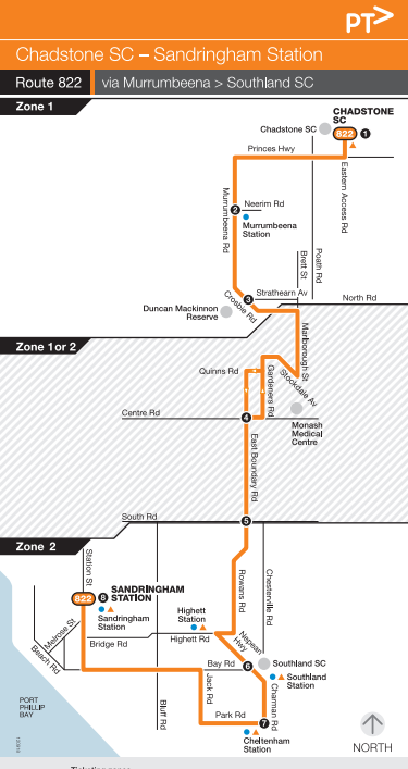
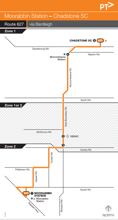
However there were instances where they were not. Especially on Sundays when two buses would appear at once, followed by a long gap to the next service. Not because of traffic, but because of timetabling. 

When it's busy, like when people finish shopping at Chadstone, people wait more than necessary because of this. Especially retail workers who, unlike shoppers, can't easily time their departure. When it's quiet, like Sunday evenings, we see two almost empty buses following each other. Neither situation is good for service, patronage or efficiency. 

This happened because Route 627 got introduced over the top of an existing network that had no changes to its routes or timetables. If you have one route operating every 40 minutes and the other operating every 60 minutes you can't space trips evenly.  That's the Sunday situation with the 627 and 822.

The annotated and merged PTV local area map below shows some bus network issues in the Bentleigh East, Moorabbin and Cheltenham areas. There's also spill-over into the Hampton and Sandringham area as both areas share some routes.   

Existing Useful Network

So much for broader network issues, what about the existing Useful Network? I explain the Useful Network concept here. It's those routes that are frequent enough and run over long enough hours to be useful for many trips. I've specified a 20 minute frequency on weekdays and 7 day service until 9pm. In other words the coloured lines on the Melbourne Public Transport Frequent Network map with the 20 minute frequency selected.

The map below shows the existing Useful Network (click for better clarity). 


East-west Useful Network routes in the area are on main roads, eg North Rd (Bus 630), Centre Rd (Bus 703) and South Rd (824). These are spaced about 1.6km apart and align well with train stations. 

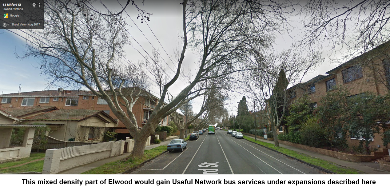
Unfortunately the north-south Useful Network is sparse. The central part of Bentleigh East has no routes or legible combinations that meet the standard, with walks of nearly 2km to either the Frankston train line or Warrigal Rd (903 SmartBus), with only infrequent access to Chadstone. The jobs areas in Moorabbin around Chesterville Rd and Bay Rd between Sandringham and Southland also miss out. 

What if you wanted to do better? That is to give more people useful bus services without a bucket more buses or money. Today we'll try this exercise for Murrumbeena, Bentleigh East, Cheltenham and adjacent areas. 

Unlike other series I'll suggest two expanded Useful Networks. The first is a lower change/lower benefit option that keeps the new Route 627. Whereas the second is a greater change/greater benefit option that merges 627 and 822 to form a major new north-south Chadstone - Southland route. 

Expanded Useful Network 1: Bentleigh East boost with Route 627 retained

This option delivers a two route frequent service between Chadstone, Murrumbeena and Bentleigh East. It retains the new route 627 on its existing alignment and service level. Route 822 retains its service level, gets moved to East Boundary Rd and is renumbered 628. The result is a 627/628 corridor with an even 15 minute frequency on weekdays and a 20 minute service on weekends. The simpler service through the heart of Bentleigh East gives better access to Murrumbeena Station and Chadstone, as you can see on the map below.  

Route 822's shift and renumbering affects where other routes go. This reshuffling is needed to retain service near all stops currently served.   

Route 701 is less used than other local bus routes. It also overlaps Route 767 in some areas. The network above shifts it to Marlborough St to replace Route 822. By serving the busier Oakleigh station (rather than Murrumbeena) it provides connections to Monash Medical Centre from a wider area. 

Route 701's occasional Moorleigh deviation gets removed. That means consistent trips with no confusing footnotes on timetables. As compensation Moorleigh gain a regular 7-day service with a minor change to Route 767. 

This network hardly changes route kilometres. Neither are there frequency increases on individual routes. Similar annual service kilometres should mean similar operating costs to today. However the simpler direct routes and new frequency corridor should make buses more useful and boost patronage, particularly in Murrumbeena and Bentleigh East.  

Expanded Useful Network 2: Bentleigh East and beyond upgrade

Here's a more radical network. It's simpler. There's fewer routes. But they're more frequent. And it brings a Useful Network standard of service near thousands more people and jobs. If you want buses to be simple, direct and more like trams then this is your network. See it below:


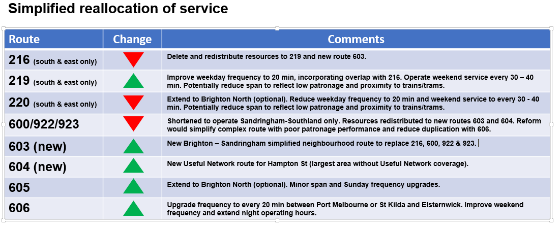
The centrepiece is a new route from Chadstone to Southland Station. I call it the 620. It's basically an amalgamation of Routes 627, 822 and part of 767. Designed to get people to trains at Murrumbeena and Southland, shops at Chadstone and Southland and jobs at Moorabbin, it can serve diverse trips all day every day. Service is every 20 minutes Monday to Sunday. Extra short trips could operate from Bentleigh East to Murrumbeena Station to provide a 10 minute peak combined frequency if resources allow.  

Bay Rd is the other major Useful Network extension. It is formed by routing 828 to Sandringham via Southland Station and Bay Rd. This direct alignment serves a busy jobs area, improves access to Southland and provides a back up for when either Frankston or Sandringham line trains are disrupted. Because the route is shorter than the existing indirect alignment to Hampton, its operating cost should be less than now. Any savings should be reinvested in frequency upgrades as Route 828 is a popular service. 

How are local routes affected? Route 701 can be realigned as per Network 1, ie via Marlborough St. Route 767 is similarly changed except for running down Rowans Rd (to replace the existing 822, or Network 1's 628). 

Running 828 to Sandringham and replacing 822 with other services creates some gaps in the Hampton - Highett - Cheltenham area. A new route 707 from Hampton to Southland via Highett and Cheltenham overcomes this. It could serve all stops the 828 does until Highett. Then it runs to Cheltenham (replacing 822) before terminating at Southland. Route 707's 30 minute frequency is designed to mesh with trains at Hampton (every 15 minutes). There is also the option of an even spacing with Route 708 (also every 30 minutes) which starts at Hampton and serves a similar catchment. This is unlike now where spacings between the 708 and 828 can never be even due to unharmonised frequencies. 

I haven't done detailed costing calculations. Like Network 1 the weekly service kilometres run is unlikely to be much different from now. The big difference is that unlike Network 1 there are fewer routes. And route kilometres are less. That frees up service kilometres for use on expanded Useful Network routes like the 620. 

That spreads benefits much more widely, to include people like Moorabbin residents, Southland shoppers and workers near Chesterville and Bay roads that Network 1 did not benefit. 

Oh, and what if you really wanted to keep the 627 that Network 2 scraps? A possibility could be to keep it running simultaneously with the revised network for a month or two to give time for people to try different network options. If patronage drops it could be made an hourly daytime one-bus route to better reflect demand. And if usage is very low then a review could ask the community whether they would prefer other upgrades, such as a Route 823 Nepean Hwy extension to Elsternwick and a compensatory 701 extension to Brighton via Dendy St. 

More detail

See the link to Useful Network map if you need more detail. You can also view it below after locating the area and selecting the menu (top left) to show whether you want to see existing or expanded Useful Networks. Top right opens it in another window if preferred.  


Conclusion

I have presented two low cost network options for buses in the Murrumbeena, Bentleigh East and Cheltenham areas. 

Network 1 uses the recently introduced Route 627 as a starting point for more useful service between Chadstone, Murrumbeena and Bentleigh East. Other areas gain simpler and more consistent services.

Network 2 also benefits Chadstone, Murrumbeena and Bentleigh East. Plus, there are further gains for people and jobs in Moorabbin, Cheltenham and Sandringham.  However, in its purest form, the network replaces the 627 with a newer, longer and more frequent route. 

What do you think? Which option is best? Or do you have other ideas on the local network?
Please comment below.

PS: Other reading. 1. Daniel Bowen's post on local buses with some history. 2. Krustylink old timetables (822 used to have a 20 min peak frequency). 


PPS: An index to all Useful Networks is here.


Tuesday, June 25, 2019

Timetable Tuesday #28: Where there's no return - Bus route 745's alphabet soup

We're not like Adelaide. Or Sydney.

Melbourne doesn't do letters on bus route numbers.

With one exception(*).

The 745.

With variations A, B, C, and D, it's one of the long term bus routes serving the City of Knox in Melbourne's outer east.  PTV's web timetable dates its last change as May 2008 but the routes have been running for decades before that. 

All start from or finish at Bayswater Station. Apart from that they don't have much in common. If it was anywhere else and they'd have their own unlettered route numbers. The map below shows their destinations.  


Primary schools normally have small (ideally walkable) catchments. It is unusual for regular bus routes to have them as destinations. However 745C and 745D do. 745B operates between two adjacent train stations via a residential area. 745A is (mostly) a main road service between Bayswater and the large Knox City Shopping Centre.  

The Knox network map below shows where the four 745s fit within the network. All are fairly short. In some cases they are about the only routes on the roads they travel on. That includes main roads like Mountain Hwy and Scoresby Rd. Whereas an inner suburb would have a bus every 20 minutes or better along such roads, and a middle to outer suburb every 30 or 40 minutes, Knox never got a real bus network when development started in the 1960s or in the fifty years since.   


Possibly the greatest surprise is the timetable. Each 745 variant has just one trip each.  Their purpose is unclear. All operate in the afternoon but appear too early or too late for school finish times. Even if you could take a 745 somewhere you can't return on it.

745A operates to Baywater, as you can see from the schedule below.


745B, 745C and 745D operate from Bayswater. Again it's uncertain who they're trying to cater for. While it backtracks towards the city direction, the 6:30pm departure is a potential commuter route. However there is no corresponding morning trip to Bayswater. 


There's 745 patronage numbers here (and reproduced below). 

They jump around quite a bit. There's no reason I can see for this since the timetable, dated 2008, has not changed in the whole period. Unfortunately they are not separated by A B C D variant. 

There's roughly 250 odd weekdays per year. With roughly 2500 passengers per year that amounts to 10 passengers across the four trips daily. In other words 2 or 3 people per trip. Which is low, given the 745 runs in school or commuter peak time. If its trips represent needed positioning moves for busier school or commuter trips, its running cost may be low. But dear or cheap, its limited timetable and consequent low patronage makes the 745A, B, C or D useful for very few people. 

What was the 745 like in the past? Krustylink has 1984 and 1991 timetables.  In both years 745 was an irregular service with many variations, like now. There was no 6:30pm trip. But there were morning trips. The 1984 bus timetables contained a handy guide to train frequencies at Bayswater. These remain fairly similar today, including the 30 minute off-peak frequency. 

What would you do with the 745? Is it worth upgrading at all? Or is it so useless that it should be deleted? Is there scope for a better bus network in the area, including along main roads? Please share your thoughts in the comments below.

(*) Actually there is one other, also in Melbourne's east, but that's a story for another time.

See other Timetable Tuesday items here 

Friday, June 21, 2019

What real network reform looks like: Regional Rail Link turns four

Today is an important anniversary. Four years since the commencement of services on the Regional Rail Link. The official opening was actually a week prior but today is the more significant anniversary.

Regional Rail Link routed Geelong trains on new tracks away from Werribee via Sunshine. This allowed trains to service the fast growth areas of Wyndham Vale and Tarneit (which never had trains before). And it freed up line capacity for more trains between Werribee and the CBD.

As for Geelong, although the line on the map appears less direct, the faster running of the trains  on its own tracks meant similar travel times to before. And off-peak weekday frequencies increased from every 60 minutes to every 20 minutes. This is a major improvement that made trains more useful for more trips including business travel. It's just a shame that the City Loop's convoluted operations (including the midday reversal) still makes getting to Geelong a lottery from the northern and eastern CBD.

Transport today would not cope without the Regional Rail Link. Although 'Regional' is in its title, the big growth in passenger numbers has come from outer suburban Wyndham Vale and Tarneit.

Five years ago Tarneit Station didn't exist. Now it's the busiest V'Line station outside Southern Cross. It and Wyndham Vale's car parks are amongst the biggest on the rail system. And well-used direct buses run from the new stations to established Werribee line stations.  This is like the pattern in the middle-eastern suburbs (eg around Mt Waverley), where north-south buses serve train lines that run east-west, providing a grid style network where both buses and trains attract good patronage numbers. When you do the same thing you tend to get similar successful results.  

More to do

The RRL remains an unfinished project in some ways. Three road-rail grade separations at Deer Park and Sunshine West (Robinsons, Station and Fitzgerald roads) that should have happened were not done. Although we think of V/Line trains as being infrequent, these crossing are so busy at peak times that more trains pass through them than those on some Metro lines.

Timetables on both the Geelong and Werribee lines now don't meet today's demand. For example Tarneit (the busiest station mentioned before) has almost a half-hour gap in departures around 5pm. Cancelling just one critical trip would cause there to be no trains for nearly 50 minutes. And the 40 minute weekend gaps are at least twice what they should be.   


The Werribee line's peak timetable is other unfinished business. The peak timetable on it and related lines (including Laverton and Williamstown) currently have an awkward 11 and 22 minute pattern. Werribee's peak timetable does not fully exploit the capacity freed by rerouting Geelong trains. This was mentioned by the Auditor-General who found that benefits from RRL have yet to be fully realised. And the government came close to but eventually did not proceed with a radical metropolitan train timetable overhaul in 2015

New bus networks

Less heralded than the RRL infrastructure and associated train services, are the bus network improvements that also started on this day in 2015. These were not mere tinkerings. Instead, almost every bus route in Greater Geelong and Wyndham (incorporating Wyndham Vale, Tarneit, Hoppers Crossing and Werribee) got a new alignment, a new number and a new timetable. A complete redesign from a blank slate. Historically significant and quite rare.

The multimode network diagram below, though not quite accurate, showed how the more frequent services in Geelong and Melbourne's western suburbs fitted together. I did it at the time as an experiment and it never went anywhere.

You can compare sections of a reformed network (central Wyndham) with an unreformed network (central Melton) below. Notice how Wyndham has direct routes that stay on its main roads with local routes serving areas in between. Whereas Melton's routes are all half and half - a mix of main road and local street running. Its basic network structure hasn't changed for years. Like Wyndham, Melton is an outer growth area and there are large areas without service.   


The big differences aren't evident on the map. Frequency. Wyndham's bus network is two-tier. Its main road routes operate every 20 minutes during peak periods. The most important of these also run every 20 minutes off-peak. And sometimes even on weekends as well (eg 170 and 180).  Local street routes in Wyndham are typically every 40 minutes - their main purpose is to provide coverage to areas distant from the main roads. Both types of routes attract good patronage, with peak usage so high that extra trips on some will start next month.

In contrast Melton's routes are (at best) every 30 minutes on weekdays (even in peaks) and hourly on weekends. Melton's mix of unreliable V/Line trains and infrequent local bus routes makes using them unattractive for commuters seeking an alternative to parking at the station. 

Geelong also got a new bus network. It was not uncontroversial. However the only people who liked the old network were existing users. This can skew results when people are asked about network changes intended to attract new riders. Like in Wyndham, many of Geelong's routes were made more direct and upgraded to operate every 20 minutes off-peak on weekdays, harmonising with train frequencies. This is summarised in the hypothetical advertisement below.


Both revised networks represent the two biggest examples of comprehensive bus network reform we've seen for years. Despite continued strong population growth and networks that need reform, nothing bigger has been implemented since.  And where bus reforms have occurred, it's mostly been in conjunction with rail extensions such as in the lead up to and again when Mernda's line opened.

A well-known motivational quote from Norman Vincent Peale is: “Shoot for the moon. Even if you miss, you'll land among the stars.”

In the context of Melbourne public transport, this could be rewritten to say "Advocate for a train. Even if you miss you'll get a better bus network". The record shows you'll probably have more success than asking for buses directly. Whether it's trains to Doncaster, Rowville, Cranbourne East or South Morang (initially) or trams to Knox City, advocates have shamed governments into providing  improved bus services at a higher standard than almost anywhere else.

That's more than seems to have been achieved by those advocating directly for buses since about 2011. Despite a strong case, advocates for bus services haven't done very well with this government. The only bright spots have been universities (with new or improved shuttle routes) and local MPs in formerly marginal seats (who have gained local routes layered over existing unchanged dysfunctional networks). Real network change has been minimal despite the opportunities presented by road-rail grade separations to renew bus networks based on improved traffic flow and easier interchange to the rebuilt stations. 

I've veered off-topic, haven't I? But they illustrate the historical significance of today's anniversary. A day, four years ago, when real train and bus network reform was delivered with substantial community benefit. May we have many more future days like it. 

For now though, enjoy the videos I made at the time. 

Regional Rail Link Open Day


RRL construction (day)


RRL construction (early morning)


Conclusion

The RRL (and its associated bus network changes) have been great successes. Maybe even too successful, with services currently straining under patronage pressure. However it paved the way for bigger and even more transformative rail projects that are now under construction. 


Note: This post appears in place of Building Melbourne's Useful Network. That's back next Friday. 

You might enjoy these well-regarded books on transport topics

Better Buses, Better Cities: How to Plan, Run, and Win the Fight for Effective Transit Steven Higashide NEW!

The Public City: Essays in honour of Paul Mees Gleeson & Beza

A Political Economy of Access: Infrastructure, Networks, Cities, Institutions (Access Quintet Book 4) David Levinson

Human Transit: How Clearer Thinking about Public Transit Can Enrich Our Communities and Our Lives Jarrett Walker

Transport for Suburbia: Beyond the Automobile Age Paul Mees

(Sales links: I get a small commission if you buy via the above - no extra cost to you)


Tuesday, June 18, 2019

Timetable Tuesday #27: The Two Followers - 627 and 822 from Chadstone

Bus route 822 has been running for years. It starts at Chadstone then goes south via Murrumbeena Station, Murrumbeena Rd, Southland, Cheltenham then Sandringham.

Its map is below. 


Bus route 627 (reviving an old number - but that's another story) started two days ago. It also commences at Chadstone (thoughtfully from the same interchange bay as 822), then goes south via Murrumbeena Station then Murrumbeena Rd. It then goes straight south via East Boundary Rd then a few local streets before terminating at Moorabbin Station. Pictures from its first day below.


In other words 627 duplicates the 822 for a bit before staying on the main road. But there'd still be common catchment for those living between the two routes. That's particularly handy if you're coming home from somewhere and have the choice of both routes at Chadstone or Murrumbeena Station. Hold that thought for later. 

627's map is below. 


The maps above are not to scale. You can see the relationship between the two routes on the Glen Eira network map below: 


This is 822's timetable (from Chadstone/Murrumbeena). Click for a larger view.  


This is 627's timetable (from Chadstone/Murrumbeena). Click for a larger view. 


I'll leave you to compare the timetables. But I do wish to draw attention to one thing. Look at afternoon departure times from Chadstone (and Murrumbeena Station a few minutes later).

Weekday ex Chadstone

Route 822: 1:34 2:04 2:34 3:04 3:34 4:05 4:34 5:08 5:38 6:09 6:36 7:06 7:40 8:36 9:29 10:39
Route 627: 2:14 2:44 3:16 3:47 4:17 4:48 5:18 5:49 6:19 6:48 7:21 7:51 8:21 8:57 9:21 9:57

Saturday ex Chadstone  

Route 822: 1:49 2:29 3:09 3:51 4:31 5:11 6:11 7:11 8:04 9:00 10:00
Route 627: 1:31 2:11 2:51 3:31 4:51 5:31 6:11 6:51 7:31 8:06 8:36 9:06 9:36

Sunday ex Chadstone

Route 822: 1:08 2:08 3:08 4:08 5:08 6:08 7:08 8:00 9:00 10:00
Route 627: 1:31 2:11 2:51 3:31 4:11 4:51 5:31 6:11 6:51  7:31 8:06 9:01

The ones in red are where departures on both routes are within a few minutes of one another. On weekdays both routes run every 30 minutes. They are roughly 10 to 20 minutes apart. This isn't an even 15 minute combined service. However it harmonises with the 10 minute daytime train frequency at Murrumbeena. Weeknight frequencies diverge. 822 drops to roughly hourly while 627 retains its roughly half hourly service all day. On only one occasion (after 9pm) are there two bus departures within 10 minutes of one another.  However if you miss that it's nearly 30 minutes until the next service.

During the day on Saturday both routes operate every 40 minutes. Departures are almost perfectly staggered, providing a combined 20 minute service. That is until about 5:31pm. By then 822 has dropped back to hourly. 627 retains its 40 minute frequency until about 8pm before going up to 30 minutes after then. Presumably this is possible with the daytime number of buses due to quieter roads and faster run times.  The uneven and then clashing frequencies mean that two buses go the same way for quite a bit within a few minutes of one another after 6pm. By about 8pm Saturday trains on the Dandenong line have dropped back to 30 minutes. Hence you would have two buses often departing at once unless you altered one route never to properly connect with the train. Or it might have been possible to operate a cheaper timetable and drop 627 to only hourly at night, offsetting with 822 to meet different trains.

Sundays present buses following one another during the day as well as at night. This is because Route 822 runs every hour versus Route 627 every 40 minutes (30 min at night). This means that buses follow one another on every second Route 822 trip. From 8pm, because both buses drop to hourly and there's no staggering of times, two buses arrive pretty much at once followed by an hour wait until the next two.  What's the bet that all those trips will be carrying a lot of fresh air then?

Over to you. Would spacing evening departures provide a better overall service? Should Route 822's Sunday timetable be upgraded to provide a more even service like Saturday's. Or would that be just tinkering and would it be better to put Route 627's resources towards wider network reform with higher frequency routes?

See other Timetable Tuesday items here 

Sunday, June 16, 2019

A look at the recent VISTA travel survey

Exactly one month ago today randomly selected volunteers were filling in forms to document their day's travel. A few days prior they downloaded a mobile phone app. That would track their movements for a week. At the end of each day they'd review gathered positions, make any corrections and input the mode and purpose for each journey, leg by leg. 


All this was in aid of VISTA - the Victorian Integrated Survey of Travel and Activity. Data from everyone's responses helps build a picture of where, when and how people travel. It feeds into the models that transport planners use when assessing future transport needs and evaluating projects.

Data provides evidence of usage. And, to some extent, demand. Although there's limitations here as one can't measure the demand of a service that doesn't exist. However we can make a pretty good estimate by looking at demographically similar areas where they do.

What happens with the mountain of analysis done? In theory there would be public transport network strategies  developed with input from sources like VISTA. However public evidence of these existing is scant. For instance we haven't seen a substantive Victorian Transport Plan for over a decade despite it being required by the Transport Integration Act 2010.


How much is our network is shaped by evidence as opposed to running what we've always run? The answer is not much. Population growth continues but network reform has stalled. For example our train timetables can reflect 1970s service cuts more than today's needs. As opposed to Sydney's  network where a 2017 service upgrade delivered fifteen minute frequencies to most stations at nearly all times - day and night.

Ditto for dead-end bus termini and timetables that persist with relics like midday Saturday shop closings. Crowding on some routes leaves people behind while others, unreviewed for years, carry fresh air through affluent suburbs.

One could conclude, that, based on recent service reform, (ie very little happening) history is king.

And because so little is done with it, data is uninfluential and therefore unimportant.  

Except when it is.

At certain times bus services have become a political issue, thanks to community, industry and academic advocacy. Governments may be galvanised into action, as occurred for a few years from 2006 when most areas got 7 day bus service and orbital SmartBuses linked the suburbs.

Sometimes effort can be wasted on matters of marginal passenger benefit, such as operator franchising, multiple rebrandings, vanity architecture (eg Southern Cross Station) and ticketing systems that no one asked for. The late 1990s and early 2000s era was notorious for that.

Meanwhile maintenance is deferred, infrastructure is failing, patronage is building and needed services aren't being added. Once that became part of a credible story about government mismanaging growth and being unable to run basic services its interest swung from buses to trains, with major timetable improvements on lines like Frankston and Dandenong. These had large benefits with train reliability rebounding from about 2011-12.   

There may be calls for a new line to relieve a clogged system. Politicians may warm to it. But evidence is needed for support to broaden, especially if it means deferring other projects or taking money earmarked for other portfolios. There's a flurry and everything is wanted yesterday.

Then data, unloved and unused for years, may be core to making a strong case when drafting and comparing alternatives. In which case it, based on what people wrote in their VISTA forms, becomes an unsung hero.

Back to the VISTA survey.

What do survey participants have to do and what data is collected?

Participants get a pack delivered to their home. It looks like this.


It's delivered by people from Ipsos, the opinion pollster and social research company contracted to conduct the survey. They'll tell you a bit about it if you're at home. 

The first thing they ask is to download a mobile phone app called rMove. Then for the next week or so take your phone with you wherever you go. This tracks where you go in conjunction with GPS data. After each day you are asked to review data accuracy and enter why you went places and how you travelled. This includes modes and connections for public transport trips and intermediate locations if you made stops during a trip. That's the first part of the survey.


The second part of the survey is paper-based.


You complete a detailed diary of your movements on a nominated day.


The survey is household based. Thus you need to complete details not only for yourself but any others living with you. You get asked demographic information such as age, income and vehicle ownership. 


Then there's details about your travel. An example page is below. It's quite a thick book. It needs to be since you're asked about every stage of your trip and you might make several of those per day. Questions asked include its purpose, where you went and whether you travelled with others. Public transport passengers and car users had their own special questions relevant to their mode. 


You can read more about VISTA on the Department of Transport's website here.

Publications making use of the data collected can be found here.

If you ever get a travel survey like this, do participate. And complete it well. Every trip counts.

You might enjoy these well-regarded books on transport topics

Better Buses, Better Cities: How to Plan, Run, and Win the Fight for Effective Transit Steven Higashide NEW!

The Public City: Essays in honour of Paul Mees Gleeson & Beza

A Political Economy of Access: Infrastructure, Networks, Cities, Institutions (Access Quintet Book 4) David Levinson

Human Transit: How Clearer Thinking about Public Transit Can Enrich Our Communities and Our Lives Jarrett Walker

Transport for Suburbia: Beyond the Automobile Age Paul Mees

(Sales links: I get a small commission if you buy via the above - no extra cost to you)

Friday, June 14, 2019

Building Melbourne's Useful Network - Part 8: St Kilda Brighton Sandringham

One of the parts of Melbourne with the most number of routes but the least service on most of them is the narrow bayside strip from St Kilda to Sandringham via Elwood and Brighton.


The area is a real demographic mix. It includes nightlife in St Kilda, young working renters in Elwood apartments, multi-millionaires in Brighton and comfortable retirees in Sandringham.  Trams serve its northern portion while the southern part is near the Sandringham train line. There used to be Victorian Railways trams in the southern part as well. These were closed down after WWII. However their legacy lives on through the long operating hours of some bus routes in the area. 

The area's increasing population density and young urban demographic (who may be more open to using public transport for a variety of trips) provide opportunities for increased patronage from a better bus network. And, as we'll discuss later, duplication of and (arguably) overservicing on some routes should make the costs of reform low.  


Existing Useful Network

I explain the Useful Network concept here. It's those routes that are frequent enough and run over long enough hours to be useful for many trips. I've specified a 20 minute frequency on weekdays and 7 day service until 9pm. In other words the coloured lines on the Melbourne Public Transport Frequent Network map with the 20 minute frequency selected.

The maps below show the existing Useful Network. It's dominated by the Sandringham train line. The northern portion also has trams.  

North-south Useful Network buses include 216/219 and 220 around St Kilda East, 605 around Caulfield South, 246 around Elwood and the multi-route 600/922/923 combination south of Sandringham.  West-east Useful Network routes include 630 from Elwood, 703 from Brighton and 828 from Hampton. The left map shows St Kilda - Brighton while on the right is Brighton - Sandringham (click for better view). 


Where the gaps in the Useful Network? Hampton St is the most conspicuous. Regular routes run near parts but there's nothing direct along its length. Given its density you might also want better service around Elwood. Four routes overlap (606 and 600/922/923) but none provide a consistently useful service. 

East-west Useful Network gaps exist near Dendy St, South Rd and Bay Rd. Reform here involves changes to out of area routes such as 811, 812, 822 and possibly 828. Changing these would affect a lot of other areas so I'll concentrate on the north-south routes today.

Notice all the loose ends in the Brighton area? This is because useful corridors often finish just short of shops and railway stations.  Network complexity also means that some corridors (eg St Kilda - Elwood) have multiple routes but with insufficient frequency for each to be useful. See map below. 


The southern termini for routes 216, 219, 220 and 605 owe more to history than being useful destinations. Routes 600, 922 and 923 are very similar but split and recombine multiple times.  Not all parts of these routes operate all day, with limited span, low frequencies and multi-hour gaps common. 922 and 923's numbering do not convey their similarity to Route 600, despite being 80% identical and knowledge of all required to successfully use them. Overall today's network is more complex than in the 1990s but gives less service.  

Service hours are also worth mentioning. It's a case of haves and have nots. Routes 246, 216/219, 220, and (to a lesser extent 600) have early starts and late finishes reflecting their heritage as ex-Met services (and before that Tramways Board). The worth of some is debatable since some of these routes run near the Sandringham train line.  In contrast operating hours are consistently shorter (9pm or earlier finish) on east-west routes such as 703 and 828 despite their unique coverage away from trains and trams. Other routes with early finishes, such as 606, 922 and 923, just make the network unnecessarily complex.  

Expanded Useful Network

An expanded Useful Network is below. Highlights include new Useful Network routes via Hampton St (new 604) and Elwood (upgraded 606). Some routes are extended to more active termini like Elsternwick and North Brighton. The overall network is simpler than what runs now, with two fewer routes.

See the link to Useful Network map if you need more detail. You can also view it below after locating the area and selecting the menu (top left) to show whether you want to see existing or expanded Useful Networks. Top right opens it in another window if preferred.  


Most or all of the resources for this network come from removing route overlaps and duplication. Routes removed include the confusing and poorly used 600/922/923 and 216. These are largely replaced by upgrades to routes like 606 and the new neighbourhood route 603.

Some resources are also freed by running some poorly used routes less frequently for less of the day. The areas that would lose are generally either close to the train or are areas with demographics unsuited to high all-day public transport usage eg Brighton. The table below (click for a better view) indicates potential resource shifts between routes.


While precise accounting has not been done, scope exists to scale down the proposed network if required. For instance the extensions of Route 220 and 605 to Brighton North are not necessary to achieve the gains in Elwood and Hampton St.  

Service priorities for expanded St Kilda, Brighton and Sandringham Useful Network

1. Terminate Route 600/922/923 to operate Sandringham - Southland only. Upgrade Route 606 operating hours and frequency to provide simpler and more regular services in the Elwood area. Make associated changes including (i) new local route 603 (to retain coverage between Brighton and Sandringham), (ii) extension of Route 630 to Elsternwick and (iii) amalgamation of Routes 216 and 219 into an upgraded 219 with minor route changes in Brighton area. 


2. Introduce a new Useful Network route between Elsternwick and Sandringham along Hampton St (Rt 604). This brings better service to a large area lacking a strong north-south route. Some resources for this could be obtained by reducing frequency and/or span on poorly performing routes such as 216/219 and 220 in areas that are near alternative services.  

3. Extend Routes 220 and 605 to a stronger southern terminus such as North Brighton. 


4. Make minor upgrades to Route 605's operating hours and Sunday frequency. 

Conclusion

The St Kilda, Brighton and Sandringham area has a lot of bus routes but often poor usage on them. However there exist growth opportunities in areas with dense housing or corridors unserved by bus. 

Unlike areas where there is no 'fat' to prune, the cost of pursuing growth here is less because of the potential to simplify the network and reallocate bus hours to where they could be better used.  

What do you think? Do you have other ideas? Are there things you see are wrong with the above? Please let us know your thoughts in the comments below. 

PS: An index to all Useful Networks is here.