Tuesday, February 26, 2019

Timetable Tuesday #12: Why two isn't always better than one - Deakin Uni's two Box Hill shuttles

The most important factor that determines the usefulness of a public transport service is not whether it's a train, tram or bus but its timetable, route and stops. 

Today we'll profile two routes and mention a third in passing.  All serve the same key destinations and need to be considered together if taking a corridor and network approach. That wasn't done when the services were put in, with, as you'll see later, consequences for service quality, legibility and frequency. 

The routes involved are 201, 768, and an extension of Route 281. They substantially overlap (see map) to provide a potentially intensive service between Deakin University's Burwood campus and the major suburban centre, rail station and bus hub of Box Hill. This is topical right now since Trimester 1 teaching at Deakin starts next week. 

Extract from PTV Whitehorse area map ptv.vic.gov.au

If you're not familiar with the Burwood campus, it is located in the middle-eastern suburbs. Frequent east-west transport is provided by the Route 75 tram.  The 75 runs from the city but is slow. That slowness is significant as it could make travel involving other routes, such as we're discussing here, more attractive. This puts Deakin in a similar position to La Trobe University on Tram 86. 

One travel alternative for Deakin is a train to Box Hill Station then a bus south to Deakin.  Box Hill enjoys a frequent daytime train service with many expresses. Catching an express shuttle bus from there to Deakin would make a lot of sense. Not only for train passengers from the city direction but also those coming from Belgrave, Lilydale and Ringwood.  Along with people arriving at Box Hill by bus and tram, particularly from the north.  

That was Deakin University's hope when the Route 201 express shuttle was launched three years ago. 

Route 201

First some background. Route 201 between Box Hill and Deakin at Burwood is one of the newer of the x01 numbered university shuttles to go in. These shuttles are designed to solve a 'last-mile' problem where major trip generators, such as universities, are just beyond reach of the rail network. Services include routes 601, 401, 301 and 201, serving Monash, Melbourne, La Trobe and Deakin Universities respectively. As long as you live near a station on the line the shuttle serves you will probably have a frequent connection to your nearest university. 

The university shuttles generally enjoy high occupancy, with an impressive number of passengers carried per bus operating hour. Their express running speeds travel. And pressure on surrounding, often crowded, all-stops  bus services has reduced. Passengers treat them as turn up and go services, with three of the four routes running every ten minutes or better. Monash University has been able to use the success of its service to advocate for service upgrades and an improved interchange at Huntingdale Station (both delivered).

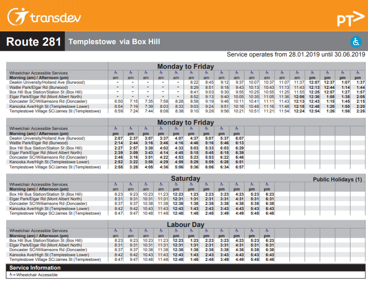
Route 201 is the exception.  The major difference between it and the other university shuttles is its low frequency (timetable below). Only trips to Box Hill are shown - service levels are similar for trips the other way. 


Timetabled run time is a flat 15 minutes, whether it is peak hour or night. The wide span of hours (7am - 10pm approx) should suit most campus users. Although a public holiday, the service runs on Labour Day as it is a university teaching day, although the cryptic note in the bottom right does not inspire confidence. Still, some clarification is provided (in duplicate with different words) under 'Service Information'. Services for 2019 commenced yesterday (February 25).  

The biggest problem though is the frequency. At every 20 minutes (even in peak times) you could be waiting for longer than the travel time to Box Hill.  It's also half or less the service of the other x01 university shuttles (all every 10 minutes or better).  

201's low frequency causes passengers to have a different experience compared to the other university shuttles. Instead of waiting a few minutes for a known frequent route to show up, they need to plan their travel around the 201's timetable. Or look around for other routes with erratic timetables (more on that later). Detailed trip planning to avoid long waits is especially required if a 
connection with a train or bus is required at Box Hill. 


As an example, above is the Lilydale line train timetable for weekday off-peak outward trips (click to enlarge).  Box Hill Station is the top line. Services operate to 15 minute frequency over most of the period shown. Beyond Ringwood frequency drops to 30 minutes on both the Lilydale and Belgrave sections. 

Because the 201's 20 minute frequency is not harmonised with the train's 15/30 min pattern, connection times vary greatly. Even though the individual services involved operate more frequently, optimum connections repeat only every hour. Whereas if frequencies were harmonised they would recur at the same frequency as the lowest frequency service. 

Route 201 lacks both the frequency and connectivity of the other (more frequent) university shuttle services. While it adds needed capacity to a multi-route corridor by itself it's not a particularly attractive service. That's why we need to mention other routes to get a full picture of what's available. 

Route 768

Route 201 is not the only short service between Deakin University and Box Hill. Route 768 commenced in July 2010, in response to crowding on Route 767, once the only service to Box Hill. While described as a shuttle it serves all stops along the route. It is mostly the same alignment as the southern two-thirds of the 201. The difference is that the 768 veers east at Canterbury Rd, with one stop on Canterbury Rd (outside a park) not served by any other route.    

768 runs between roughly 7am and 7pm. Its frequency is an uninspiring 40 to 50 minutes.  Unlike the 201 the 768 has a variable run time - between approximately 13 and 20 minutes. Route 768 is a Trimester 1 and 2 service only  (different to the 201 which appears to operate in all three).  Its 4 March commencement date is a week later than for the 201 and there is no mention of a Labour Day service.   


Route 281

This is not a dedicated university shuttle service. However it's included here for completeness. For it, like 201 and 768, also departs from the stop inside the campus. Services operate on weekdays every 30 minutes as a southwards extension of the regular route to Templestowe. This extension commenced in April 2010, just before the 768 started. Route 281 runs on all non-public holiday weekdays (including those that are not in a Deakin trimester). On Labour Day it runs a Saturday timetable, which excludes Deakin University despite being a teaching day.  


Summary of existing service 


Of all the university campuses with rail shuttle bus services, Deakin is the least served. This is despite growth in the number of bus routes between Deakin and Box Hill from 1 to 4 in the last decade.  Rather than introducing a high frequency shuttle that's so frequent everyone uses it, the approach for Deakin has been to layer multiple infrequent routes and extensions over one other without reviewing what was there underneath. A bit like a bad paint job.


This started in 2010 with the extension of the twice-hourly Route 281 trips to Deakin on weekdays. Shortly afterwards Route 768 commenced. Then little happened for a few years.  In fact frequency on nearby Route 767 was cut from 30 to 40 minutes (before being restored recently).  To fill the gap Deakin instituted its own shuttle from Surrey Hills in 2014. In 2016 Route 201 was introduced, but at a lower frequency than the other main university shuttles. 


The result is a complex and uneven service uncoordinated with trains. The combined frequency is high but splitting service across multiple routes lessens the benefit with long waits alternating with bunching. Semester and public holiday teaching day variations add further confusion. These problems do not arise on other campuses with their more frequent uni shuttles.


There is however hope for Deakin's shuttle. There are no planning reasons why it can't run as frequently as the others. And the high number of trips per hour presents opportunity for improvements at minimal additional operating cost. Especially if you can harvest run time benefits from this traffic signal priority trial on Route 201.

Some possibilities


Consider the following:


1. What if we were to consider the three routes that enter the Deakin campus (201, 281, 768) jointly? Could they be coordinated to provide a more even frequency, and if so would a better overall service be possible? 


Current service levels are as follows:

Route 201: 3 trips per hour (inside campus)

Route 768: 1.3 trips per hour (inside campus)

Route 281: 2 trips per hour (inside campus)


Adding them all up gives 6.3 trips per hour. If you were good with your spacing you'd have an even ten minute service if all routes were run every 30 minutes each. However unless other things were fixed, such as public holiday patterns and information presentation, legibility would still be poor. And, while not insoluble (as it's been done elsewhere) there's the issue of coordinating Ventura (201, 768) with Transdev (281) timetables. 


It would be an interesting scheduling exercise. But the service would remain complex. And the nice even frequency would likely be undersold, given PTV's current difficulties with communicating high combined frequencies along existing multi-route bus corridors. 


2. What if you just wanted to work with two routes - that is the two that were intended to be Deakin shuttles but are each too infrequent to do the job well on their own? Routes 201 and 768 operate at a combined 4.3 trips per hour. 


The simplest approach could be to delete Route 768 and incorporate all trips into an upgraded 201 operating every 15 minutes (12 min if possible in the peak). Such a frequency is still worse than the other uni shuttles but would harmonise with trains and many buses at Box Hill. Travelling would be simpler since unless a 281 was close by you'd almost certainly just wait for the upgraded 201. 


Subsequent improvement options could include a 7.5 or 10 minute frequency, with the latter possible at low cost (but likely some controversy) if the 281 was pruned back to Box Hill.  A 7.5 min service is nearer to true turn up and go while 10 minutes would mesh well with trains if the weekday interpeak Ringwood line timetable was upgraded to a 10/20 minute frequency pattern (ie similar to weekends). 


The question is: What (if anything) would you do with the 201, the 768 and potentially the 281? Do you like one of the above options or are there better ideas? Does the 768 have a purpose at all? Extra points if you consider wider area travel needs and other routes in the area like 732, 767 and even the 903.

Timetable Tuesday simultaneously appears on melbourneontransit.blogspot and as an article on the Urban Happiness Facebook group. The timetable extract was from the old PTV website . 


See other Timetable Tuesday items here 

Saturday, February 23, 2019

[Housekeeping] Melbourne on Transit now on Twitter

Follow Melbourne on Transit at https://twitter.com/MelbOnTransit 

I'll tweet alerts of blog posts and convey transport news and opinion from others.

You can see Twitter activity on the right.


Friday, February 22, 2019

Be the first to know about almost anything happening in public transport: Researcher sources revealed

Even just in Victoria, public transport is such a vast field that it can be a battle keeping up with developments. New happenings are often first flagged on Twitter or sometimes a Facebook page or closed enthusiast group. More substantive information may then be available on a website or video on YouTube.

While the links below are (mostly) to websites, don't forget to check their Twitter and Facebook posts if you have an inkling that something big could be happening. 

Australasian Bus and Coach Good source of industry news. If one company buys another or you enjoying reading articles about people in the industry you'll likely find it here.

Get Involved A site sometimes used when the government wants to consult the public on a transport project or service change.

Infrastructure Victoria Produces reports and strategies often affecting transport. Long term stuff - what government does is up to it.

Parliament of Victoria Search here for Hansard (including speeches that mention transport), committee reports and annual reports. Annual reports are timed to report on the financial year just gone. They typically appear in a deluge near the end of the year when parliament is still sitting. You may need to search under both Legislative Assembly and Legislative Council to find everything. Annual reports may also be placed on the website for the respective organisation after they have been tabled.

Public Transport Ombudsman Read their annual reports for details of the most complained about issues on our public transport network. PTO also has an active Facebook page advising passengers of their rights and obligations.

Public Transport Users Association Passenger advocacy group. Regularly posts on Twitter and Facebook.

Public Transport Victoria Where you go for maps, timetables, journey planner and service information. Also see Network performance for regular reports and, for what is to come, Improvements and projects. They also tweet

State government media releases - transport Find recent announcements here. And if they are area specific look up the local district seat, find the MP and track down their website/Facebook/Twitter etc for news. Local newspapers and Facebook groups can also be helpful, reporting items that may be missed by the larger outlets.  

Transport Operators List is on the PTV website. They sometimes have details of service changes or disruptions. Some are active users of Facebook and/or Twitter. 

Transport for Victoria An umbrella site for transport in Victoria. They don't yet tweet but you can view their videos

Transport Safety Victoria Often breaks news about the results of bus safety inspections, compliance activities and prosecutions of dodgy operators. Their Twitter is worth following.

Victorian Auditor Generals Office Check their website regularly for reports on the management of public transport agencies and projects.

Victorian State Budget The state budget is handed down each May. The budget papers are published online shortly after the budget speech is delivered. These show allocations for new capital works projects and planned spending for service delivery. There is also often reporting on public transport patronage and forecasts for the following year. 

The above are mostly industry and official sources. You can also often get early warnings on Twitter accounts maintained by individuals, commentators and media. Even if you're not signed up to Twitter enter key words here to get tweets. Blogs (like the ones linked on the right) are useful. 

Also cast your net a bit wider. Collaboration between transport authorities and academics is often reported on university research or transport research forum websites. Consultants or contractors often showcase work such as a network review or advertising campaign they do for a public transport authority. And don't forget a Google, Youtube, Twitter or Facebook search using a few key words.  Online council meeting minutes sometimes contain documents from state government agencies that are otherwise inaccessible. And sometimes you can find items that have sunk to obscurity (maybe because they were written under a previous government) but still contain valuable information.

Often you need history to know the full significance of a change made today. Transport agencies and operators, with their constant restructurings, rebrandings and website reorganisations, aren't the best custodians of this. If you know an old URL then the Internet Archive Wayback Machine is your friend. Go to the National Library's Trove for old newspaper reports. And any serious historian will have scoured the Victorian Parliamentary Papers Database where they can trace significant decisions and read important reports such as royal commissions and technical investigations.

As for service changes and historical maps, BCSV's Virtual Museum is good as is the curiously-named Krustylink for 1980s/90s timetables. Victoran Railways has many old documents. Back issues of Table Talk from the Australian Timetable Association are a must-read. Along with old forum posts from the Australian Transport Discussion Board and Railpage forums from the days when online bulletin boards were more a thing. A Google search with the forum name and a few key words will often be rewarding. 

Serendipity often plays a part. Just last week I was searching for something else (confirmation of as-yet unreported word-of-mouth news). I wasn't successful in that. But I did find some other material.  While somewhat out of date now it was a KPMG report that government would have paid thousands of dollars for on how all the public transport agencies fit together.  Read all the four parts here (pdf). 

To conclude: listen widely, read widely and search widely. Then you'll often be the first in your group  to know stuff. If you have other handy information sources, please leave them in the comments below.

You might enjoy these well-regarded books on transport topics

Better Buses, Better Cities: How to Plan, Run, and Win the Fight for Effective Transit Steven Higashide NEW!

The Public City: Essays in honour of Paul Mees Gleeson & Beza

A Political Economy of Access: Infrastructure, Networks, Cities, Institutions (Access Quintet Book 4) David Levinson

Human Transit: How Clearer Thinking about Public Transit Can Enrich Our Communities and Our Lives Jarrett Walker

Transport for Suburbia: Beyond the Automobile Age Paul Mees

(Sales links: I get a small commission if you buy via the above - no extra cost to you)

Tuesday, February 19, 2019

Timetable Tuesday #11: Melbourne's Cinderella tram - Route 82

The most important factor that determines the usefulness of a public transport service is not whether it's a train, tram or bus but its timetable, route and stops.

This is the first week we've featured a tram route. That's for several reasons. They are relatively few. They are generally direct and rarely deviate. And there aren't huge disparities in their operating hours or minimum service frequencies.

But there is one significant exception. Tram route 82 between Footscray, Maribyrnong and Moonee Ponds. It's different from other trams in Melbourne for three main reasons.

First of all the 82 doesn't look like your average direct tram route with one or two turns. Instead it has something like eight bends. A bit like a local bus route.  Although there is one of those (the limited-service route 404) that is faster and more direct between Footscray and Moonee Ponds than the tram.

Secondly, particularly between Footscray and Highpoint, there's significant route overlap between the tram and buses. Often the destinations are the same as well.

Thirdly Route 82's history is different, part being the only surviving remnant of the Footscray tramway system. The rest closed in 1962, to be replaced by buses (Routes 216/219, 220, 223) whose frequent service and long operating hours reflect the Tramways Board heritage.  This history also largely insulated these routes from the severe evening and weekend service cuts that pruned many privately operated bus services from the 1960s through to the 1990s.


What's along Route 82? Footscray is its southern terminus, with gleaming new towers poking above gritty shops that would be condemned if anywhere else. The station was rebuilt as part of Regional Rail Link. Through-routing of Metro trains to Frankston improved access to the south-eastern suburbs while new and upgraded regional lines better connected it with the western and northern half of the state, Geelong and the city of Wyndham.

A few wheel screeches later and the 82 is at its nearest point to Victoria University's largest campus. However it's not outside the campus and there's a bit of a walk across a large car park to get there. Bus route 406, in contrast, gets you to the door.

The story is repeated for Highpoint Shopping Centre. The tram goes near but turns off just before the centre's centre.  Buses again go closer. Maribyrnong is a rapidly developing and densifying area without fast links to Melbourne CBD. And due to the decision to route the 903 SmartBus along Buckley St, Essendon (where it duplicates an existing bus route) it lacks high quality access to Essendon and Sunshine as well.

82 then heads east, overlapping the 57 tram, crosses the river, north to Ascot Vale before terminating at Moonee Ponds Junction where it meets other tram and bus routes, including Routes 404 and 472 from Footscray.

Due to Footscray's isolated tram network legacy, Route 82 is one of two daytime tram routes that, even if you stay all the distance, will not get you to Melbourne CBD. Instead city connections are made by changing to a train at Footscray. There is also a same-stop transfer to the (slow) tram route 57 or a short walk to the (fast) train at Ascot Vale. Its suburban-only operation is why the 82 (along with the 78) does not normally receive  extra service when big CBD events are held such as White Night.

What other special things are there about Route 82's timetable? Its weekday daytime service is most obvious. People are used to regarding trams as a 'turn up and go' service. They don't always look at the timetable as they know there will be one shortly. Scheduled weekday daytime maximum waits are between 8 and 12 minutes on most tram routes. 

That's not the case with Route 82. That comes only every 20 minutes (timetable below). Nearby bus routes have a similar or better frequency. E.g. 223 (every 15 min), 406 (every 20 min) and 472 (every 15 min). If you want to make short local trips, such as between Highpoint, Victoria University and Footscray these waits are a significant proportion of total journey time. While average combined frequency of all routes is high, the uneven spacing, different modes and different stop locations reduce the benefits of this compared to if a smaller number of routes at higher frequencies ran.


Weekends are different. 82's Saturday (and Sunday) timetable has a 15 minute daytime frequency. That makes it like other tram routes. 82's quirk is that it's the only tram route that has a better service (15 min) on weekends than on weekdays (20 min). The other main metropolitan example is the Belgrave/Lilydale rail line at every 10/20 min weekends versus 15/30 min weekdays.


 How about evenings? 82 is similarly short-changed Monday to Saturday. Here the basic service is every 30 minutes versus 20 minutes on the other routes. On Sunday evenings the 82 operates to the 30 minute headway usual on tram routes.


As for Sunday mornings, these are a mix of 20 and 30 minute frequencies with a slightly later start than found on other tram services.


To conclude, Route 82 has had a different history to other tram routes in Melbourne. This includes part being the only survivor of the separate Footscray tram system. The Footscray Tramway Trust was dissolved 99 years ago this month. Service commenced in 1921 under Melbourne and Metropolitan Tramways Board control. Nearly a century on, in terms of service levels, the 82 remains the 'poor cousin' relative to other routes that the entire Footscray network was before it closed.


The question is: What (if anything) would you do with the 82's route and timetable? Extra points if you consider wider area travel needs and other routes in the area such as the 223, 406 and 472.

Timetable Tuesday simultaneously appears on melbourneontransit.blogspot and as an article on the Urban Happiness Facebook group. The timetable extract was from the old PTV website . 

See other Timetable Tuesday items here 

Friday, February 15, 2019

Where have all the network maps gone?

SUBTITLE: SOMETIMES GOOD THINGS HAPPEN - SEE UPDATE

Why would one produce transport maps and then make it hard for passengers to find and use them?

It's got me beat. But it's a good question given how difficult it was to find multimodal public transport network maps when the new PTV website started.  

The pdf maps that show multiple routes and modes for a local government area or regional city were particularly elusive.  You know the sort that, thanks to intersecting routes, tells people that public transport can take them to multiple places they didn't think reachable. Something a backpacker might pick up at a country tourist bureau.

Or, if one line or route is disrupted or has a limited timetable, a map that shows nearby alternatives could be helpful. Even a 30 or 40 min walk to one may still be faster than waiting for a disrupted service to resume or replacement buses to arrive. That's the sort of insight a journey planner or call centre operator won't necessarily provide, at least without spending more time than they can spare.

Before we start our fishing trip, let's have some history of multimode public transport network maps in Melbourne. This will demonstrate that having multimode maps is not unreasonable since they have existed in some form for nearly 50 years.

* 1971: All bus routes were renumbered to the three digit system we know today. A fold-out metropolitan network map was produced.  This map was regularly produced by successive agencies including The Met, PTC and Metlink until about 10 years ago.  Two c1990 editions of this map were displayed at Flinders Street Station in or near the Degraves St subway until at least 2008.  The remnants of where one was mounted can still be seen near the barriers.


* c1980: The Melway street directory started to show bus routes on its street maps.

* c1990s: Some railway stations had Melway street maps (showing buses) erected in poster cases on their platforms.  Maps were often from Edition 25 (1998).  Many remained up well into the 2000s despite subsequent network changes. 

* 2000s: The creation of Metlink and the introduction of minimum service standards for most local bus routes also saw improved passenger information.  Fold-out network maps based on local area, were produced from the early 2000s.  All bus stops got timetables. And, as you can see from the picture (Williams Landing, 2013) they also got local area network maps. Service upgrades, outer suburban fare cuts and improved information contributed to booming bus patronage during this era.


* c2014: Local area maps started to get removed from bus stops and be replaced by generic information on myki ticketing. This would have reduced signage installation costs; a minor change to one route could have implications on the accuracy of maps at hundreds of stops that (strictly speaking) would need changing.  The trade-off is that removing maps made buses (already thought twisted and tricky) even more difficult and less attractive to use.


* c2016: As per the article above, falling bus patronage was a concern. One of our big bus operators (Transdev) was on a franchise contract that rewarded patronage growth. If patronage fell the contract would be less sustainable (and in fact they later had problems). 

To help out PTV ran the Melbourne by Bus campaign to promote bus use.  There were posters and brochures with stunningly beautiful images that would not have been cheap. And an online bus network map just for the campaign.  Nice but probably limited impact. The single-mode focus also undermined the passenger-centred multimodal approach espoused elsewhere including in the Transport Integration Act (pdf - you should read it).


* 2018/9: Most recently we have the new PTV website. Whereas the old 'classic' website was a website with a journey planner incorporated, the new website is more like a journey planner with a website attached.

The new site prioritises planning one trip today over communicating what the network can do - present and future.  The route timetables, maps and upcoming service change information that form the basis of traditional public transport websites were pushed to the side with this one.

What has this to do with maps?  The new website has a page for maps (under 'more').  The classic website also has a page for maps (under 'Getting around').  On the new website the new PDF maps are mostly single modal, with the main exceptions being for regional train and coach services between towns.  And a bit of multimodalism appears on the event precinct maps. But there is not the same range of multimodal pdf network maps we had last year.

However you do get other types of maps when you call up a route or do a journey plan. These are the maps that PTV says you should be satisfied with when you ask about network maps on their Facebook page. They only show the route you pick or the routes in your journey plan. Not surrounding routes like the PDF maps did. Both types have their uses but there is a risk that the new version is closing the user's mind regarding the network options around them. You can see the difference in information below. 


Individual route maps are also affected. Look up a route such as 200, 250, 386, 411, 802 or 811 on the classic website and visit its map. You will get a multi-route map showing overlapping closely related routes that combine to increase frequency on the common section (example below right). 

That's useful to know as a more frequent service is more attractive than a less frequent one. Whereas on the new site, unless you select the combined timetable option which isn't always available, you just get a map for the one route selected (below left).  Another example of the new site prematurely closing off options (although other aspects of the new maps are nice).


Getting back to multimodal pdf area maps, can we still see them on the old ('classic') website?  It looks promising with a link provided to local area maps (circled). And PTV will assure you on their Facebook page that all the maps we enjoyed in 2018 remain on the 'classic' site. But clicking just takes you to the new PTV site. 


This is where it's best to be on a desktop computer. You use the right mouse button to inspect the website code.  It looks like this:


Paste the text somewhere, eg Word, insert 'classic' instead of 'www' and paste into your browser. Or just click https://classic.ptv.vic.gov.au/getting-around/local-areas . Now you have the page that we remember from the old old PTV website. That is the one before the new page took over and they put the word 'classic' in everywhere. As far as I can tell it's an unloved orphan with no links from either the new or old (classic) PTV sites.


Click on this page and save all the local area network maps you want. Even if just for posterity.  Bad luck though if you're in regional Victoria; the regional city network maps outside Melbourne local government areas don't seem to be there. 

This is where you go to Google and do a search. Sometimes a link to something may be removed but the underlying item (or a previous version) remains.  Be aware though that the item might not quite be up to date. For instance this Geelong network map.  Or you might find maps on third party sites such as maintained by councils, tourist agencies or enthusiasts who value them highly.

Sometimes maps are in places one wouldn't expect. The encyclopaedic 192 page Victorian Fares and Ticketing manual is a great source. From Page 82 you will find network maps for the larger regional cities.  It puzzles me that if all the effort is done to prepare a map for an obscure document few passengers see, why not make it public so it has a wider benefit?

Where have all the network maps gone? Many still exist, especially for Melbourne local government areas. It's just that, having been removed from bus stops, and now publicly linked parts of the PTV website, they're not easy to find.  And when you do find them save them quickly in case they go.

What is PTV's attitude to network maps? Do they regard them as important? As part of research for this post, I asked PTV about them via their public Facebook page. And I wasn't the first or only one to raise the topic. You can read the whole thread here.  The discussion was quite long but the salient answers are below (or skip to the bottom of you're short of time).

1. First of all PTV say they do not have a network map "solely for the Geelong area". David then asks for them to be restored.


2. PTV says that maps are on the old website (I discussed previously - the link that looks useful goes to the new site). Mention is also made that the old site won't be around for long.


3. I ask about whether maps from the page (that does work) will be incorporated on the new website.  I then prompt for an answer (as I'm researching for this post!).


4. PTV talk about interactive maps (which is not my question) then say the downloadable maps are on the old website.  We know that the old website won't be around for long so the future of downloadable maps looks grim.


5. David explains why PDF maps are necessary.


6. PTV says they only have the interactive map that you can bring up one route at a time.


The message here is that PDF local area network maps were not considered important by PTV when asked multiple times by different people. Once the old website went then these maps would also vanish. And early on they denied a map existed for the Geelong area.

My opinion in contrast was that multimodal network maps are essential for passenger navigation and should continue to be available. Not only downloadable via the web but also at interchange points on the network. Their restoration at bus stops would be nice, too.  Hence this post.

UPDATE 15 FEBRUARY 2019: PDF NETWORK MAPS RESTORED

After this post had appeared I received advice (comment below) that local area maps were back. Not just for Melbourne local government areas but regional as well. This is great news. See right at the very bottom of https://www.ptv.vic.gov.au/more/maps  Thanks to PTV for responding to online feedback so quickly and making it happen.