Tuesday, November 30, 2021

Timetable Tuesday #144: Bus 732 - Burwood Hwy's tram connector

Which is Melbourne's most frequent 7 day bus route? It's neither a SmartBus nor something in a dense inner suburb that replaced a cable tram. Instead it's a short section of a suburban route boosted because the early 2000s era government only half fulfilled a promise to extend the 75 tram to Knox City. The tram was extended from Burwood East to Vermont South with the remainder to Knox being a bus. The 'Knox Transit Link' is just one of the multiple roles served by Route 732 between Box Hill and Upper Ferntree Gully in Melbourne's east. 

For a Melbourne bus the route is amazingly straight with just one significant bend. It starts at Box Hill and runs due south, skirting the eastern part of Deakin University. Then it runs east along Burwood Hwy until Upper Ferntree Gully Station. 


Burwood Hwy is a significant transport spine in Melbourne's eastern suburbs. Many shops and corporate headquarters are lined along it. Tram 75 along it has been extended several times, with Vermont South being the current terminus. Route 732 overlaps part of the tram but has the benefit of running to Box Hill which is a major destination for people in the area. Another overlap is further east, in a sparser area. Here the overlap is with the 693 though this is different in that it deviates north via Ferntree Gully. 

Arguably, the further east you go the less there is a need for a one seat ride to Box Hill as taking the train will probably be quicker. However this is not necessarily so when comparing it with a bus + train trip noting the poor (30 min) interpeak frequency of trains on the Belgrave line. 

You can get a better idea of the 732 from the annotated network map below. 


The full route runs from Box Hill to Upper Ferntree Gully station. A dotted line east of there is an off-peak daytime loop to serve Angliss Hospital. The thick line is the Knox Transit Link from the tram terminus to Knox City Shopping Centre. This includes a lot of short trips to provide a frequent service and connections from each tram (in most cases). 


Route 732 serves a swathe of seats in Melbourne's east - all marginal. These include Box Hill (Paul Hamer MP - Labor marginal), Burwood (Will Fowles MP - Labor marginal), Forest Hill (Neil Angus - Liberal marginal) and Ferntree Gully (Nick Wakeling - Liberal marginal). The redistribution will reduce the number of seats in the area but many will likely remain marginal. 

Timetable and service levels

The timetable for the 732 is best explained in two parts: (i) the full route and (ii) the Knox Transit Link section between Vermont South and Knox City. 

The full route almost but doesn't quite meet the 2006 minimum service standards. That is service up to approximately 9pm seven days per week with maximum intervals between trips of an hour. 

Monday to Friday interpeak service is three trips per hour from the unusually early start of 5am. However its times are uneven with gaps of up to 27-28 minutes. Thus it gets close to but does not qualify for inclusion on my Useful Network frequency maps, which have a maximum wait cut-off of 20 minutes. Another issue is that even if it was an even 20 minutes it would not harmonise trains at Box Hill due to these following a 15/ 30 minute pattern (despite a more suitable 10 / 20 minute pattern operating on weekends). 

Saturday service is roughly 40 minutes during the day and 60 minutes at night. Sunday service is mostly about hourly. However it doesn't quite meet the hourly minimum service standard as intervals are lumpy. For an example there is gap of around 90 minutes in the morning and around 75 minutes inbound from Upper Ferntree Gully. The span is asymmetrical, with the last weekend buses leaving Upper Ferntree Gully at 8pm as opposed to after 9pm for Box Hill. 


The Sunday timetable excerpt above shows how much more intense the Knox Transit Link service is compared to the route 732 as a whole. In addition the Knox Transit Link operates over almost the same wide operating hours enjoyed by the 75 tram. The concept was there would be a seamless tram / bus connection, though in 2011 the PTUA complained this wasn't so

Noteworthy though was when the 75 was one of the six tram routes chosen for Night Network operation in 2016 the connecting 732 Knox Transit Link bus did not get a corresponding 'meet every tram' upgrade. Instead the link is provided with the hourly 967 special Night Bus route. More recently late night 732 service was cut earlier this year, presumably due to low usage. 

In the morning peak the short 732 trips operate about every 8 to 10 minutes. Interpeak service is about every 10 minutes for the short trips on their own. However the full route passes every 20 minutes or so, reducing some gaps to 5 minutes. Arguably this is excessive - one wonders whether economies might have been possible with short trips being spaced between the full length trips. This would however require the full length trips to be run at an even 20 minute interval, which is not currently the case. This does not happen as the bus operator concerned (Ventura) tends to avoid clockface timetabling, even interpeak and on weekends. This is because our Department of Transport does not enforce network-wide frequency planning standards. In this we lag Switzerland, which does through its Tactfahrplan (clockface) scheduling policy.  


Early Saturday morning frequencies are every 20 minutes, improving to 12 minutes for most of the day. Like on weeknights evenings drop to approximately every 20 minutes with some unevenness. Service is least (about every 30 minutes) early Sunday morning and evening to reflect the drop off in tram services then. 

History

The 732 as we know it has been going since 1980, though there have been similar routes going back to 1944. For much of the 1970s it provided a bus along both Highbury Rd and part of Burwood Hwy, with other routes (735 and 736) going further east along Burwood Hwy. Both have since been made less direct with the 732 becoming the main Burwood Hwy route. 

The short Knox Transit Link trips between Vermont South and Knox City were added in 2005. These ran as extra trips in between the full length 732 trips. Hence you had Melbourne's most frequent bus service on the overlap section while the full length route was the usual six day per week / short operating hours service typical of Melbourne buses. This went a long way to being corrected a couple of years later when the full 732 route gained an (almost) minimum service upgrade in 2007 with longer operating hours and Sunday service. 

For a long time (up to early 2021) the 732 was scheduled in a manner where the short Knox Transit Link trips combined with the full length trips to provide the high Vermont South - Knox City service. However the 2021 service change decoupled them to make them effectively separate services. While this might have improved the reliability of the Knox Transit Link part of the service, it resulted in a 'lumpy' timetable with some trips only two minutes apart. Also the number of trips added may not have necessarily been the most efficient use of bus resources in Melbourne's east given (a) Knox Transit Link's low usage and (b) the extreme lack of bus services in parts of Knox (such as Scoresby Rd). 

Patronage

The 732 is one of the busiest bus routes in the eastern suburbs. Both in terms of overall patronage and boardings per service hour. The latter is 35-36 boardings per hour on all seven days with the highest number recorded on Sundays. This is due to a combination of a favourable bus using demographic (most likely at the electorally marginal Box Hill end) and the poor hourly service provided. High productivity can wreck a bus route with the 732 on weekend a prime example. 

The goodness of the 732's catchment and the strength of Box Hill as a centre appears to offset its overlap of the 75 tram on Burwood Hwy. The bus goes to Box Hill and the tram doesn't so they have different roles. Where both routes perform strongly and the catchment is favourable then you might accept what you might at first sight consider a duplicative service. 

The Knox Transit Link further east is a different story. Board one of the short trips and there often won't be that many other passengers. It's a frequent service but it is very slow if taking it all the way to the CBD. Camberwell (on the way) may attract some but not necessarily very many passengers. Certainly having more buses between Vermont South and Knox City than trams that they meet is overkill not justified by patronage numbers. Especially when the number of such trips was greatly increased in the early 2021 recoordination.

Another thing about the 732's extending so far east is that it precludes many one-seat rides, even for local trips, for passenger boarding routes south and east of Belgrave without even more network duplication than currently exists. This may be one of the reasons for the low patronage productivity of routes like the 695. It may be possible for it to do better if it ran to a major destination like Knox City instead of the 732.  

Reform options

Route 732 has a lot of potential for reform. Not least because it serves the major centre of Box Hill, just misses Deakin University and will just miss the proposed Burwood Suburban Rail Loop station. And, as mentioned above, parts of the route are well used while other parts are poorly used, despite its strong overall usage. 

The map below is a potential network concept for a reformed Deakin area trunk bus network involving the 732 and 903. 


In a nutshell both the 903 and 732 are rerouted to better serve Deakin University. As well the short poorly used Knox Transit Link trips are replaced with frequent service all the way between Knox City and Box Hill. This may seem expensive but resources can come from amalgamating the 201 and 768 Deakin University shuttles into the extended 732.

An attempt could be made to lessen run time with express / limited stop running between Vermont South and Box Hill, with the tram or the 767 available at all stops missed. Service could be every 10 minutes weekdays and 20 minutes weekends, with the inferior weekend tram connections at Vermont South accept as a price for the vastly improved frequency to Box Hill. Every second trip could extend from Knox to Upper Ferntree Gully to preserve the existing 3 buses per hour but (hopefully) with a more even 20 minute interval. This would nicely complement needed upgrades of Belgrave line weekday interpeak services from every 30 to every 20 minutes. 

If funding is limited a 15 minute weekday frequency between Box Hill and Knox City may be acceptable. This has the advantage of evenly meshing with the current 15 min base train frequency at Box Hill and, if every second trip is extended to Upper Ferntree Gully, trains there as well. And, while still not quite 'turn up and go' it would offer a superior service to the 20 minutely Deakin 201 shuttle. The main trade-off is inferior timetable coordination at the Vermont South tram terminus (trams every 10 min, bus every 15 min). But you are still getting a much simpler network and far better Deakin access at a very small cost. 

The eastern part of the 732 also bears looking at. Simplification might involve operating the Angliss Hospital trip full time as part of a regular route extended from the east that might make other local trips easier. It might be possible to consider this in conjunction with reforms to 693 and 695

Conclusion

Route 732 tries to do a lot of things. Does it do too much? Or are there more things it could do, eg a better Deakin University connection? Does the Knox Transit Link get too much service while the Box Hill end gets too little? And is there scope for timetable neatening, such as an even 20 minute service and more weekend trips? Comments are welcome and can be left below. 


See all Timetable Tuesday items here


Friday, November 26, 2021

UN 113: A new bus network for Hampton Park (and more)


Today we'll venture to Hampton Park, in Melbourne's outer south-east. The area has had a station at Hallam for years with rapid housing growth in the 1970s and 80s. Main roads form the 'bones' of a coarse grid, with loopy streets and creeks interrupting it at the finer level. This makes it harder to simplify local bus routes without losing coverage. Also, unlike older suburbs, housing density and commercial activity peaks at 1 or 2 km from the station, with less around the station itself. 


The area has had quite a few piecemeal bus reforms over the last 20 or 30 years. Early numbers were in the high 700s (eg 792, 793, 794). Route numbers we know today (892, 893, 894, 895) started in August 2002 . The 891 started in 2010, replacing 827 in Hallam Gardens. The 2016 Cranbourne network saw major changes to 892 and 893 with the latter becoming a more direct and frequent route. However other Hampton Park changes were planned but did not proceed. More recently 863 from Endeavour Hills was layered over an unchanged existing network in the Hallam area. 

Lynbrook station opened in 2012. It got one bus route running to it but did not spark a comprehensive reappraisal of the local bus network. Its only route to the Hampton Park area is the 891 with other local routes, such as from Narre Warren South, going near but not to the station.

The average bus in the area is indirect and runs approximately every 40 minutes. The main exception is the 893 which was upgraded to every 20 min 7 days per week as part of the 2016 Cranbourne upgrades. This is a direct route running from Dandenong to Cranbourne via Hallam Station and Hallam Rd. There are no routes of equivalent (or indeed any) quality running east-west such as between Lynbrook and Narre Warren South even though there is now a lot of housing well away from the nearest station.  

The main destinations for Hampton Park people include the local shops on Hallam Rd and Fountain Gate in nearby Narre Warren. There's a lot of employment in nearby Dandenong South. Further away are jobs, services and education facilities in Dandenong and Berwick. The area sits between the Pakenham and Cranbourne lines with local stations being Hallam, Narre Warren and Lynbrook. 

Notwithstanding earlier comments about difficult street layouts, the bus network is more complex than it should be. The 2010 Metropolitan Bus Review proposed simplification but was never implemented. Even by suburban route standards, both routes 894 and 895 are very complex. They go a different way during peak and off-peak periods to save service kilometres. However this makes them almost unfathomable, especially if you look at the PTV's website maps below. 


Worthwhile bus network reform in Hampton Park must involve simplifying these routes. There are also complexities with buses in Narre Warren South with loop routes and weak termini. However discussion of them will be held over to another day. 


Hampton Park is in the state seat of Narre Warren South. This is held by Gary Maas MP. It is regarded as being fairly safe for Labor. Changes will be made to seat boundaries in the area due to the redistribution.  

Productivity of existing routes

All local routes have about average or better patronage performance on weekdays as measured on a boardings per kilometre basis (first number to the right of the route number). Numbers are for late 2018 (supplied by DoT). 

890 25/6/2
891 35/21/13
892 37/31/17
893 42/29/17
894 21/11/7
895 29/23/14

Saturday and Sunday usage (second and third numbers) is low on routes 890 and 894 as neither link residential areas to major shopping centres. 894 is also very complex. However 892 and 893 (which go to Dandenong) are strong performers while 895 (which goes to Fountain Gate) also performs well on Saturdays. 

The newer 863 from Endeavour Hills to Hampton Park is the least productive with half or less boardings per service km performance of the abovementioned. It has little unique coverage and doesn't go to major shopping centres. I won't discuss it today but it could be useful if wider reform was attempted.

Few frequent routes

As mentioned before the average bus in the area runs every 30 or 40 minutes. There is only one route  (893) that runs at the same frequency as off-peak trains (every 20 min).

I looked at main routes through this area before. Useful Network Part 26 examined corridors for potential frequent routes in the City of Casey while Part 97 considered potential SmartBuses in an even bigger part of the south-east.

Those items left some loose ends as local routes didn't get much mention. That's this item's purpose. I'll discuss local routes, notably in Hampton Park. However some of the benefits are wider, extending to Lynbrook Station, Narre Warren South and Berwick as you'll learn later. 

A reformed network

Network reform was considered with the following aims: 

1. Simplification of the very complex 894 and 895 routes with consistent all route service all day.

2. Improve connections to the station at Lynbrook and jobs at Dandenong South. It won't be possible to provide a one-seat ride for Dandenong South jobs from everywhere. But Dandenong South's 890 can be made to intersect with most routes in the area, permitting access with just one connection. 

3. Retain connections to shops at Fountain Gate and Hampton Park as much as possible, noting that there's often a trade-off with directness due to the location of the latter.  

4. Provide for direct routes that could be given frequent service if resources allowed. 

5. Retain residential area coverage. Stops retained in all but very few cases (where alternatives would be available). 

6. Relatively self-contained and simple to implement with a focus on the network's main problems. Berwick and Narre Warren South's network also needs reform but could be done in a subsequent stage. 

A potential reformed network is mapped below. 


A description of and rationale for the revised network is below: 

890: The current route runs to Lynbrook via a section of Westernport Hwy with no stops. It currently does well on weekdays but not on weekends as it has little residential area catchment that isn't close to Lynbrook Station. Lynbrook station is itself a weak terminus since it has a train and just two other bus routes. Hence travel to Dandenong South from many areas like much of Cranbourne, Hampton and Narre Warren South requires an unattractive bus-train-bus trip involving two changes, mostly between or two infrequent services.

The revised network takes 890 away from Lynbrook and routes it through residential parts of Hallam and then north to Hallam Station. It would then continue to Fountain Gate. This would enable increased weekend usage. Access to Dandenong South is better with connectivity with key north-south routes from Cranbourne including 893 on Hallam Rd and 841 at Fountain Gate. The 890 also replaces part of the very complex 894 with a straighter route that adds access to Fountain Gate. 

891: No change to route. However it might be scheduled so it combines with the new 894 to provide a combined 20 minute service to Lynbrook and Fountain Gate from some areas. 

892: Rerouted to replace 894 on Lakeview Dr. This lessens overlap on Hallam Rd which since 2016 has had the upgraded 893. This change frees 894 to do other things as explained later. A weekend frequency upgrade from every 60 to every 40 minutes is suggested, especially on Saturdays. This would partly compensate part of Pound Rd which goes from 2 to 1 route west of Hallam Rd due to the 894's simplification. Departures from Dandenong could be staggered with 890 to provide a 20 min combined frequency to Hampton Park west of Hallam Rd. The Ormond Rd part of the 892 would gain more frequent service to new destinations due to reforms to the 895 discussed later. 

893: No changes to route. However wider operating hours are suggested to reflect its status as a major route and provide after 9pm evening and early morning weekend service in the area. Due to Dandenong's more frequent trains, bus/train connectivity could be optimised at Hallam Station where trains are less frequent.

894: This complex and indirect route is radically reformed to go the same way each time. It would now provide a connection to Lynbrook and Fountain Gate. The latter should assist with improving currently low weekend usage. 

895: This also involves a radical reform. So radical that you might give it another route number like the 852 mentioned here. It is basically a direct Lynbrook - Berwick route. It's a thicker line as it's a potential more frequent service. Frequency could be every 20 minutes all day, particularly on weekdays. Its role is as a train feeder at both ends and to connect people to hospitals and educational services in the Berwick area. The directness and speed should assist usage despite its overlap of other routes at the Berwick end. Bus-bus connections may also be possible with the 893 (every 20 min) and a potentially upgraded 841 to provide a (currently missing) network grid. 

Resourcing

Bus vehicle usage for the existing routes involved is roughly as follows: 

890: +1 bus. Existing 40 min service needs 2 buses. The revised route is longer so 1 more bus is assumed. If that isn't sufficient it may be possible to interline it with the 892 at Dandenong which will  gain layover time. 

892: unchanged: Existing 30 min service with 40-45 min run time would require 3 buses. Revised route is longer but dropping frequency to every 40 min would leave bus requirements unchanged. Any surplus time at Dandenong could assist the extended 890 (also run by Cranbourne Transit). Ideally departures from Dandenong would be staggered with 890 to provide as close to a combined 20 minute frequency as possible to Hampton Park west of Hallam Rd. 

894 & 895: +2 bus: Existing 40 min service uses 3 buses on 2 hour cycle interpeak. Timetable is consistent with routes interlining at Narre Warren South terminus. Peak period short-cuts are economical but add to complexity. The new 894 would have similar length and 40 min frequency as 891 so should use 2 buses, leaving one to be put towards the 895. 

The new 895 via Seebeck Dr on the map is about 11.4 km long. Running it via Casey Central Shopping Centre would make it about a kilometre longer. Despite it being a little less direct it is potentially more useful and connects with more routes so running via Casey Central is on balance desirable. An 11km long route permits an efficient hourly service with one bus on local streets. Three buses could permit the 20 minute frequency recommended. The 895's direct route along main roads may allow somewhat faster speeds, with the ideal being a 20 minute service via Casey Central with three buses. 

Overall this network needs three new buses. It may be possible to get away with fewer but this is not recommended as it would mean poorer service on the new direct route 895. However if additional resources were available consideration may be given to boosting peak frequencies on 891 and 893 as these enjoy above average usage on weekdays.    

A network option B

Every proposed network will have shortcomings. Thus it is not wise to draw up just one network and think 'this must be the one' since this will make you blind to its deficiencies. At the same time you should not lose heart and give up. Especially when you have an existing unsatisfactory network and nothing has been done in nearly 20 years to fix complex routes like 894 and 895.

In the first network's case both 892 and 894 go near but not right to Hampton Park Shopping Centre. The difference is barely 100 metres but it will still annoy passengers, especially the less mobile. 

Another fault with A is that it doesn't tackle inefficient overlaps enough. In fact its extension of 890 to Fountain Gate creates new overlaps along Princes Hwy. Economies may be possible if another way for this route could be found. 

The network option B (below) presents another approach. 


Notable changes include: 

a. 890 and 892 west of Hallam Rd are flipped. This routes 892 past Hampton Park Shopping Centre instead of 890. It's a trade-off here: which route should have the best access to Hampton Park Shopping Centre? Another approach could be to introduce a kink with a small amount of backtracking so that both do. 

b. The 894 from Network A is deleted. Parts of it are replaced by the 890 which is routed to Narre Warren Station and Fountain Gate via the existing 895 alignment. Arguably this more east-west alignment is more legible while still making possible a lot of bus-bus and train-bus connections for the 890. It should also make the 890 a strong weekend patronage performer instead of its current weakness.

Other parts of the 894 around Coral Park Primary School retain service by diverting the 891 through the area. 891 would become even more of a coverage type route, especially if it is, as on the map, deviated via Fordholm Rd to better serve Hampton Park Shopping Centre. However those willing to walk to direct routes have the 893 and the revised 895 with their more frequent service. A partial solution could be to terminate 891 at Hampton Park Shopping Centre and extend 863 to Lynbrook via Coral Park. This would speed travel as access to Hallam Station would be direct instead of via Willow and Oaktree.

Network B is more economical than Network A. This is because removing 894 would free up its two buses. One might be needed for the 891 due to its extra length. It may then be possible to upgrade 891's peak service to be nearer to 30 than 40 minutes. This is a small but desirable improvement. The other remaining bus could be put towards the 895 upgrade. Hence Network B may require only two new buses instead of three for Network A. 

The economy of Network B reflects a common issue with bus network reform. Existing unreformed suburban bus networks in Melbourne are dominated by indirect and overlapping local routes running every 30 to 60 minutes. In Melbourne's east there are no SmartBuses east of Ringwood or Dandenong. Even routes running at moderate frequencies, like every 20 minutes, simply don't exist in many areas. 

Cost-effective reform might require merging two local routes so they become less direct while retaining coverage. However doing so may have an overall gain as they free up buses that could be used on frequent and direct routes. The latter tend to be more popular with passengers so adding them is a good way to grow network patronage. Example two-tier networks like this operate in Wyndham, Brimbank and Cranbourne. 

Conclusion

New bus networks for Hampton Park and surrounds have been proposed. 

Both are simpler than the current network and delivers new 20 minute more frequent service between Lynbrook and Berwick. Connections to jobs at Dandenong South are also improved.

Special effort has been made to retain service at pretty much all stops buses currently call at. Where this isn't the case there will be a stop nearby. 

More routes run directly to stations. There are fewer 'dead end' termini. The networks are also compatible with subsequent reforms for Narre Warren South and Berwick which have similar needs for simplified routes.

Which network do you prefer? Or maybe there's third and fourth options that could be better still? Maybe you can draw inspiration from the (mostly unimplemented) Cardinia/Casey bus network review done about 10 years ago?  Comments are welcome and can be left below.  


Tuesday, November 23, 2021

Timetable Tuesday #143: Up to 115 min between buses - Scoresby’s unloved 757 758 twins


Little exemplifies the stagnation of buses in the City of Knox more than the two bus routes we’ll talk about today. 757 and 758 started as limited service daytime shopper services in 1982 to then new subdivisions. Nearly 40 years later that remains their role today. 

I’m doing them together since their histories and alignment parallel. For example they started on the same day, are of similar length and have similar service levels. Both run south from Knox City, finishing at a dead end terminus near Ferntree Gully Road. They are like inkblots on card with Stud Road forming the crease. 757 is west of Stud Rd while 758 is east. Both have complex loops near their bottom ends. Compare them below: 


The maps above can be zoomed in on the PTV website but they miss other information. Possibly more helpful is the City of Knox network map below. 


This shows the 757/758 mirror image more clearly as well as these routes’ role. Basically they are coverage routes servicing pockets off the main roads. Road layout design has made such routes more necessary. This is because traffic engineering doctrine states that main roads like Stud Road should be limited access with residential streets behind them having, at best broken grids, and at worst ‘spaghetti style’ streets.  This results in main roads having limited walk-up access for main bus routes and local routes (like 757 and 758) being slow and indirect. Neither are conducive to efficient, well-used and economical bus networks. 

In terms of coverage, 757 serves the strip of housing between Eastlink and Stud Rd. It has pretty much unique coverage if you ignore the Stud Rd routes.  758 covers the wide area between Stud and Scoresby roads. In the south it has overlapping catchment with the complex 753, though they have differing destinations.  

Both routes have multiple loops in their bottom section. In some pockets they are the only public transport within reasonable walking distance of homes. Both southern termini are weak. On the map they intersect with the 693 along Ferntree Gully Rd but its unlikely few would make connections due to low frequencies and poor pedestrian access. Neither the 757 nor 758 run to any train station. Hence a city trip using one of these routes would be a multi-hour affair with two or three changes. 

Timetables

Both routes run Monday to Friday with no weekend or public holiday service. Like many routes in Knox they missed out on the ‘minimum standards’ upgrades of 10 to 15 years ago. The number of trips on both routes can be counted on two hands, with some digits remaining.

Operating hours are limited. Starts are roughly 8 to 9am with finishes 5 to 6pm. This makes them suitable for weekday shopper trips to Knox City and possibly some school trips. 757 starts and finishes earlier than 758, with neither having sufficient span to provide a generally useful commuter service. Frequency is also limited; Intervals between services average about 90 minutes with some approaching 2 hours. 

Patronage

Both routes are poorly used, attracting less than half of the average number of boardings per service hours compared to the rest of the network. On weekdays (the only day these routes run) 757 attracts 10 boardings per service hour with 758 slightly busier at 11. 

Although the catchment is regular outer suburbia, everything about these routes contributes to their poor patronage performance. This includes their restricted operating days, hours and frequency. They don’t run to a train station and their southern termini aren’t anywhere useful.  Consequently about their only use is for Knox City shoppers, and even there other routes like the 901 provide a more attractive service due to their higher frequency if people can tolerate the extra walking. 

Conclusion

The 757 and 758 routes are both underperforming and unloved. Reviews about 10 years ago suggested reforms but none got implemented.  More recent governments have emphasised infrastructure at the expense of service so nothing has happened lately either. 

I’ve already said what I’d do with bus services in the Scoresby area – you can read it here. If you've got any thoughts please leave them in the comments below. 


Friday, November 19, 2021

UN 112: How well connected? Suburban Rail Loop's EES


What is the proposed Suburban Rail Loop?

A visionary city-shaping project that sets up up for the future? A development-enabling project to foster suburban job clusters (NEICs) and land value uplift? A transport project? Or, more cynically, a political project? Maybe it's all four? 

Whether you consider its construction good value or not, it's undeniable that the SRL concept is of wide appeal. Even transformative for those who find our existing public transport too limiting for the types of non-CBD travel that now dominate where we work, learn, shop and play. 

This is because current infrastructure and service levels emphasise travel into the CBD over other directions. All of our trains are radial. Ditto for all but a few tram corridors. Buses are mostly not radial but almost never provide full-time service.

Our orbital SmartBuses were the first real attempt to address this just over ten years ago. However even then their half-hourly weekend timetables looked like something from another age with poor connections to trains. And, without dedicated infrastructure, they are prone to bunching and traffic delays.

SRL executive James Tonkin likened the existing rail network as spokes without a wheel at a recent Eastern Transport Coalition meeting. SRL would connect the spokes and provide a true network. 

More detailed information about the SRL came out two weeks ago through its Environmental Effects Statement for the first, eastern portion ('SRL East'). I'd encourage you to read as much as you can from it (there's a lot there, including seven tabs worth of documents). Note their warning if you download the pdf files and rely on those. They're incomplete. In their own words: "This printable chapter of the EES replicates the text from the digital EES platform, but does not replicate the interactive figures and maps."

You can make a submission. The deadline is 16 December 2021. The sheer amount of material means that no regular person with normal responsibilities will be able to read it within this period. Let alone make a submission. There is thus a risk that they will receive few submissions and that this will be taken as being consent or acceptance of the proposed plans.  

This item will (I hope) help you with a few of the EES topics. For brevity I'll focus on the connectivity aspects in the transport oriented documents only. I will also leave out temporary disruptions due to construction and other issues such as the location of the train stabling. 

Report structure

You might want to start off reading the Summary Report. More detail is in the chapters. These have two or three letter codes, normally relating to the initials of their titles. Even more detail is in Technical appendices. These have a letter <dot> number. These are mostly divided into existing conditions (EC) and impact assessment (IA). Generally the ECs are .1 while the IAs are .2. There is also a Map Book and Surface and Tunnel Plans. 

I'll now go through the sections of the EES document I found most of interest. 

Introduction and Purpose (Chapter IP)

This starts with an overview of the Suburban Rail Loop. Basically a 90km orbital railway through Melbourne's middle suburbs to support suburban centres that bring jobs and services nearer more homes. Important for what will be discussed later, it will connect every major suburban rail line between Frankston and Werribee. SRL East will feature six underground stations between Cheltenham (Southland) and Box Hill and turn-up-and-go service. 

The EES assessment is required to consider broad social, environmental, economic and transport impacts of the project. The conclusion of this process is a planning scheme amendment following approvals. 

It's important to know what's not covered by the EES. These include (i) initial works, (ii) precinct structure planning, (iii) other parts of SRL (north and north-west), and (iv) interchange works. The latter is particularly important. The full excerpt is below: 

SRL East intersects with Metro trains at Southland, Clayton, Glen Waverley and Box Hill. However only at Clayton station will the project deliver a 'paid area connection'. That is you will be able to change between trains without having to touch on and off. Provided walking distances are short this is considered the 'gold standard' for connectivity between lines in metro systems.  

Other stations like Southland, Glen Waverley and Box Hill will involve connections at ground level and having to touch on and touch off. This imposes a higher transfer penalty compared to sites with easier interchange. Planning for this is the responsibility of the Department of Transport, and not this project. And wording like 'any dedicated passenger walkway' doesn't exactly inspire confidence. 

The risk is that here, at the first hurdle, this critical aspect of connectivity may be declared 'out of scope'. We might not get the best, or even a good outcome. In James Tonkin's terminology, there could be a risk of the 'wheel' not connecting to the 'spokes' very well. 


Technical Appendix P.1 Social and Community Existing Conditions (TAP.1)

Basically about what's there now. If there's say a farmers market or skate park on land a new station will take over or otherwise affect it then it's written about here. Also pages 8 and 9 give a brief overview of SRL East, including a map.

There is a summary of legislation affecting it and various local council policies. Page 19 outlines interactions with other reports. Most of interest is that known as 'Traffic and Transport Existing Conditions report' (Technical Appendix R.1, or TAR.1). More on that later. 

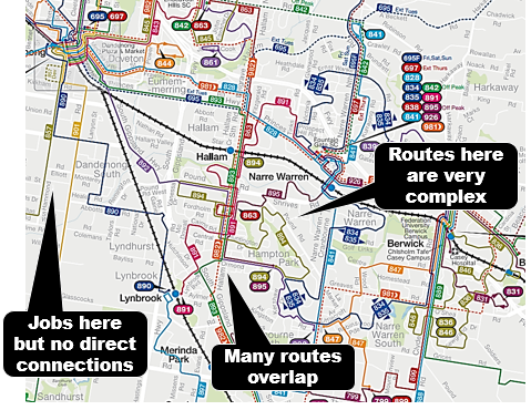
There is a Key Social Assets section for each station precinct (and more). These contain maps showing the SRL station relative to existing (Metro) stations and other attractions. Southland's map omits the existing bus interchange in the shopping centre. However it's mentioned later.   


Traffic and Transport Existing Conditions report' (TAR.1).

Another 'what's there now' but focusing on transport. Described the nature of the existing network, including rail's radial nature and the slowness of public transport for cross-suburban trips, especially in the eastern suburbs for north-south trips. This is attributed to them only being possible by bus (p2) but their being mixed in traffic and/or infrequency might be more exact reasons.

Existing network connectivity is especially mentioned with regard to the SRL station at Southland. Here they draw attention to the disconnectivity between the existing station and bus interchange. As well as poor active transport access. The excerpt below is from pages 2 and 3.
 
The existing Southland railway station is located to the west of Southland Shopping Centre and south of Bay Road and is considered within walking distance to the SRL station at Cheltenham. The Southland  Shopping Centre bus terminal is located on the eastern side of the shopping centre across Nepean Highway. This facility is undercover, with seating and other infrastructure for passengers.

Cheltenham has a comprehensive bus network, with 13 bus routes that serve the existing bus station. However, the bus station is not integrated with Southland railway station. The SRL station at Cheltenham Study Area generally has a high dependency on private vehicles. The main roads (Nepean Highway and Bay Road) are heavily car-dominated. Pedestrian and cycling access to Southland railway station is hindered by several physical barriers, and meandering routes through areas of poor amenity with perceived safety concerns. At present there are no continuous, high-quality, and modeseparated cycling corridors running north–south or east–west through the Study Area. Cyclists generally share road space with high speed general traffic or use the footpaths.

Similar comments are made about active transport for Clayton. Of particular note is mention of high walking activity despite poor accessibility. 

Monash University's bus interchange serves the south end of the campus. The SRL station will be near the north end. This is acknowledged to have good road access but limited bus services. 

Similar comments for Clayton apply for Glen Waverley. That is an existing bus interchange near the station, high pedestrian activity but poor accommodation of it in the road network. Poor walking connectivity and car dominance are also recurring themes for Burwood and Box Hill despite the latter's substantial connectivity with various public transport modes. 

Maps and tables showing usage of routes and lines in the SRL area are included. Analysis shows that public transport takes about twice as long as driving in the am peak for various trips around the SRL corridor. 

As part of existing conditions, various transport policies and priorities of councils are set down. 

There is much more detail than covered here. However I'll say that the analysis does a good job at assessing issues such as connectivity between public and active transport modes. If such standards are applied to the connectivity that will happen post SRL then I think the EES will have done a good job. 

Impact Assessment and Summary - Traffic and Transport (TT)

At least early on the pdf version of this document isn't very useful as graphs etc are on the online version. Thus it is incomplete. I also couldn't find much correspondence between the pdf documents and the online version, for instance if you wanted to find a table or graph that was omitted from the pdf version. 


I didn't find the 4 minute how to video helpful and in the end just gave up. This is unfortunate. By making information about it hard to access, the SRL risks demonstrating that the bigger a project is the less open, accountable and accessible they appear to be (and get away with it). Meanwhile hundreds of more widely beneficial and cost-effective small infrastructure and service projects wither on the vine for lack of funding. 

Anyway, let's get back to the incomplete pdf chapter and see if anything useful can be salvaged. Fortunately it can be. Page 12 says that the SRL will be overwhelmingly good for the transport system, though there might be 'localised minor increases in travel times' for tram and bus trips due to changes to the road network. For example some buses around Glen Waverley. 

Later we are assured that "For each SRL station, the Project would create efficient connections and interchange experience for people transferring between different modes, and improve safety for all road users and particularly for pedestrians and bicycle riders."

They assume the SRL will bring about increased population and land use change around the stations. This comes with a warning - despite the increase in public transport patronage, this increased activity would "increase the number of trips on the local road network".

Also "... the Project would exacerbate congestion due to access requirements to the stations". For this to be minimised providing good bus, cycling and walking access is key. And larger centres like Monash need a really good internal transport network similar to frequent trams in the CBD. How this would tie in with the SRL should be key but the EES document gives few clues. 

SRL assume catchments of 1600 metres around their stations. The vast majority of this 'last mile' area is outside reasonable walking distance, especially for stations (like Southland) with huge road and building barriers to walking permeability. Here too bike and bus access is important.  

Good bike access requires off-road access over a wide area around stations, including separation and priority at road intersections which documents admit will be passing more cars. Good bus access needs improved and more frequent networks. Nothing I've seen in the SRL EES material indicates that we are likely to see best practice connectivity between public transport modes, noting that only Clayton is guaranteed something like this with trains (reflecting its 'Superhub' status). More detail on how long connections will take at each station will appear later. 

What's the SRL's impact to overall public transport usage? Page 13 has the answer. "Overall, as a result of the Project there would be a one per cent mode share shift from private vehicle to public transport, indicating that SRL East would offset the impact of additional development opportunities anticipated across Melbourne’s eastern suburbs.". More information is in a table that unfortunately doesn't appear in the pdf document. 

The rest of the paper goes on in more detail. It is somewhat confusing in that they refer to an SRL station at Cheltenham, even though it is nearer to Southland and there is a Cheltenham station on the Frankston line. Of note is that a better located bus interchange would be provided. Better Bay Rd connectivity would be a plus especially if a direct route to Sandringham was included. Although the SRL doesn't extend to Sandringham, the area will gain improved access according to published maps. 

This is another point. The SRL appears a stand-alone single-mode project. It vaguely mentions but does not detail substantial bus network reform, even though this will be both necessary and desirable. This is a different planning approach to (say) Perth, which has developed a reformed local bus network in conjunction with their (under construction) airport line. Such work, if included in the business case, could have increased the benefits of the SRL project, especially given the issues mentioned before with traffic around the stations. Not to mention the concept of 'SRL SmartBus' which could encourage some SRL development and travel patterns prior to rail services commencing. 

I won't go through every interchange in detail here. But there's a few points worth mentioning. Clayton looks the pick of the bunch. A significant point is that SRL entrances are on both sides of Clayton Rd. That should help connectivity with more direct bus routes. 


Monash's interchange really needs bus network reform because otherwise few buses will service it. I didn't see even a notional concept bus network in the EES material. The nearest they get is 'potential increase bus services' (page 55). Much more is needed given that the Monash precinct has fast roads and coarse blocks that limit internal permeability.

Glen Waverley gets a large deviation to Route 737 that would increase its travel time as roads enabling its direct route would be closed. This is a popular route that provides a Monash - Knox City connection. The possibility of network reform is mentioned here. 

Technical Appendix P.2 Social and Community Impact Assessment (TAP.2)

Basically lots of good things. Or you'd hope so for billions of dollars! This includes better connections to jobs, education and a lot of active transport improvements as a byproduct. The latter is similar to how grade separations have added bike paths to areas that didn't previously have them. While they shouldn't need a bigger other project to fund their construction, in practice they did. 

The main adverse impacts is the resumption of private property (including homes) and temporary or permanent use of open and recreational space. Most controversial has been train stabling in a 'green wedge' area. 

Traffic and Transport Impact Assessment report (TAR.2).

Again the summary is 'lots of good things'. But transport wonks need to pay more than usual attention to this section as there's lot of interesting stuff. Trust me. If there's only one paper you can read it should be this. 

We are again assured that "The transport interchanges proposed as part of each SRL East station have been designed to maximise interchanges with other public transport services and enhance pedestrian and cyclist access to the stations.". 

How frequently will SRL run? Page 50 assumes 10 trains per hour during peaks. There will also be 24 hour service on weekends, similar to the Night Network on Metro trains. However connectivity between the two will be pot luck unless services improve to be better than hourly.

Page 3 says that SRL will generate another 44000 public transport trips, ie 9% greater than the 'no project' scenario in 2041.

As an aside it would have been interesting to see whether alternative ways of generating that number sooner and at lower cost under some other combination of infrastructure and service. However one would then be reminded that the SRL is more than a transport project with city shaping impacts compared to (say) just boosting lots of buses. Our projected population is 9 million by 2056 and cities such as London and Paris got orbital type rail transport when they were smaller than that.

Car use would still grow but with SRL public transport use would grow faster as the SRL greatly improves the latter's accessibility. This is currently very low for most Melburnians, with far more jobs within (say) 45 min drive than 45 min of public transport. 

From 5.2.1: "For example, between 2018 and 2041, travel demand across Metropolitan Melbourne is forecast to increase by 50 per cent. By 2041, there would be almost 22 million daily private vehicle trips (70 per cent growth on 2018) and 2.6 million daily public transport trips (85 per cent growth). 

In 2041, the capacity that SRL East provides would increase public transport trips across Metropolitan Melbourne by around 76,000 per day. It is also forecast to help reduce private vehicle use by around 97,000 trips per day. This reduction is broadly equivalent to removing the total number of vehicles per day travelling towards the city on the Monash Freeway, prior to entering the Domain Tunnel, in 2018." 


It's outside the scope of the project, but it would have been interesting if two other maps were shown with a different 'basket' of projects. For example with and without North-East Link. It seems a bit rich spruiking the car use reduction benefits of SRL without also comparing it with the car use increase characteristics that building freeways tends to bring. 

Another comparison could have been a hypothetical alternative based on other orbital transport upgrades and improved buses. My rough comparison of the latter is here. SRL is big, but reformed bus could be bigger. Although, in the SRL's favour, it is possible that because it will be faster, the passenger kilometres generated by SRL may exceed that from better buses because SRL's speed induces more and longer trips. So much for 20 minute neighbourhoods!

What about rail network usage? The opening of the entire SRL (by 2056) will somewhat increase patronage on the outer portions of radial Metro lines and decrease usage of their inner portions (p51). This looks like a better utilisation of radial lines as some trips that were in and out of the city are accommodated on the SRL and there would be some turnover of seats at SRL served stations.

Especially if the NEIC clusters develop you would also think that orbital rail would make radial rail less 'tidal' with more evenly balanced inward and outbound usage during the peak. This would be another good thing for network efficiency. Note though that all this is based on pre-COVID commuting patterns and we don't yet know how the pandemic has affected long term patterns. 

What is expected to happen to public transport usage by mode? Figure 5.4 has projections that compares 2018 with 2041. The latter year has 'project' and 'no project' scenarios. High growth is expected across all modes between 2018 and even the 2041 'no project' scenario. Largely I think due to high population growth and an assumption that people will continue to work, live and travel as they did in 2018. 

The substantial added gains for rail are attributable to the SRL and 'network effect' on the radial lines. Buses show a big gain to 2041 whether the SRL is built or not. I'm not sure if this can be assumed.

Even though Melbourne had strong population growth in the period up to 2019, for much of that period bus usage didn't grow much on a metropolitan wide basis after about 2011. I'd attribute this to a lack of bus network reform in all but a few outer suburban areas and service quality and delivery issues on a lot of Transdev routes (including the SmartBus orbitals). Notwithstanding population growth I think we will need substantial bus network reform to deliver the numbers projected. That includes lots of extra bus  service kilometres, not just small 'cost neutral' reforms that can only do so much. More detail on what's needed here.

What's SRL's impact on bus usage? It's basically indiscernible if you look at the graph. The real story is likely a reduction in long distance orbital type bus trips and an increase in shorter feeder trips as the SRL replaces a lot of the former. Hence bus passenger kilometres might be about the same, even if total number of boardings picks up slightly. If you want the areas around SRL stations to fully develop free of constraint from car access and parking then the role for buses will need to be greater than projected, especially for short trips within NEICs (which are too large to be walkable so need good tram-like internal transit) and feeders to SRL and other stations. 


Car parking? Whenever you mention access to stations, car parking is never far away from the discussion. Lots of parking at stations seems to be the expectation and politicians frequently promise more even in established areas. The latter particularly has very high costs per passenger and may not even be feasible due to lack of space. 

The SRL EES recognises this reality well. From Page 58: "Given the location of the SRL East stations in established areas, no additional parking is proposed to be created by SRL East. Commuters would be able to park at the 46 Metro stations on the Belgrave, Lilydale, Pakenham, Cranbourne and Frankston lines further east of SRL East and at other stations closer to the city where relevant and have a one interchange journey to an end destination at an SRL precinct.". 

Public transport is a great freedom and opportunity enhancing enabler. Some great graphs on page 53 show how the SRL can do this. Improved accessibility around all the stations brings around a million more people and hundreds of thousands more jobs within a 60 minute ride of each. Station to station journey times (admittedly the best case scenarios) are cut by as much as 75%. And some go from being twice as slow as driving to twice as fast.

These are real habit-changing numbers. They are a great selling point for development within the precincts themselves. But connectivity with trains and buses, along with network reform for the latter is key to ensuring these benefits spread more widely. Even though some may have a commercial interest in ensuring they don't, pitting the landholder's desire for scarcity to drive capital gains against the public transport planner's wish for abundant access.

Page 58 recognises the need for bus reform here: "These would be supported by more direct route alignment and increased frequencies on key corridors to encourage an increase in patronage and integration of public transport modes." However no network concept is provided.

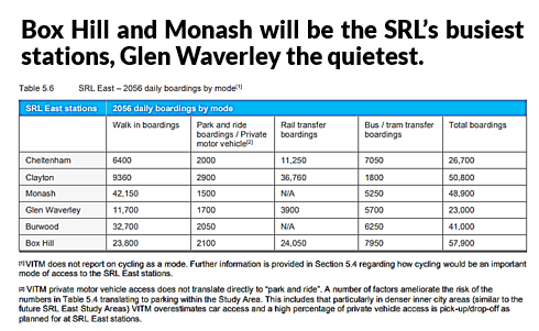
How busy will SRL stations be? Box Hill and Monash will be the busiest overall. Access means will vary greatly. For instance Monash and Burwood will be walking dominated, whereas Clayton will be rail transfer dominated. Both Cheltenham and Glen Waverley will have a high proportion of bus boardings. Clayton will have by far the lowest access by bus even though its physical connectivity to them (especially Clayton Rd routes) may be the best of all SRL stations. 

There are some gaps in the data, as indicated in the footnotes. Unforgivable for a transport model (as what isn't measured doesn't count), VITM does not report on cycling as a mode. Last-mile access is critical to the success of SRL stations given the 1600m radius used in material for it. This is well beyond the normal walkable catchment for stations which is usually assumed to be about 10 minutes or 800m. As a comparison, if 1600m was considered adequate catchment for a station there would have been no need to build any of the City Loop as all of it is within 1600m of either Flinders St or Southern Cross. SRL works around VITM not counting cycling by setting a 15% access target for it. 

Here's where the rubber hits the road. For the talk about the importance of connectivity between modes, how well does what's planned for the SRL accommodate this? Before we discuss this you need to know the difference between good and bad. This video shows this with recent Melbourne station builds.  


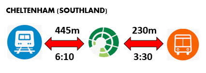
Watch the video to experience the difference between a 1 minute and 5 minute interchange. Reflect on whether you'd want the latter to be part of your routine twice a day, especially in inclement weather.  Bear it in mind as you see the numbers that follow for each interchange point. Both distances and walking time (min:sec) are given. 


Diagrams are mine, numbers are from the EES. Note that I've only stuck to the numbers published. Hence access distances and times between Metro stations and bus interchanges are not given. However they are important for a truly integrated interchange.

While I've stressed physical connectivity between bus stops and the SRL, this is only half of the story. If a bus has to pull in to an interchange and U-turn to go back out again (like they do at places like Glen Waverley) then that is a bad thing as it adds travel time for those making through trips. Added travel time also makes it more expensive to provide a frequent service. Even worse is that this is a long term operational cost. Instead you want both quick passenger interchange and direct through routes for buses. The video example for Ormond above successfully combines these. 

Conclusion

I've only touched a fraction of a percent of topics I could have. For example I've not discussed wider urban planning matters. The SRL EES is a large body of work, probably beyond the scope of one person to review. So if you've had a look I'd love to read your thoughts. Comments are welcome below. And if you feel strongly about something, lodge a submission in the next three weeks! 

Click here for other Building Melbourne's Useful Network items


Tuesday, November 16, 2021

Timetable Tuesday #142: Have they got it right? Melton South's new FlexiRide

For a while not much happened with buses in Melbourne. Now things are hotting up.

But not in a way that you might expect. Rather than merely seeing reform and strengthening of the fixed route network, we are now witnessing the emergence of dual competing and overlapping bus systems in some of our suburbs.

Planned without reference to the other, each has different information systems, mobile apps and even public holiday service arrangements. Each has backing from within differing sections of the Victorian Department of Transport.

Recent and current DoT management has been very attracted to flexible route buses. Recent examples include the (now departed) Megan Bourke-O'Neil and current Departmental Secretary Paul Younis who last week before PAEC credited FlexiRide Rowville with a 2000% (!) patronage uplift compared to the previously (poorly used) Telebus. DoT marketers have been similarly effusive, describing FlexiRide as 'Passenger Power'.

Planners several rungs below tend to be more skeptical, being concerned about the poor track record and high opportunity costs of flexible routes. They stress the unrealised potential for cost-effective reform to existing fixed routes which have too often sat unreviewed for years. This perspective has not necessarily enjoyed much sway in top DoT ranks nor amongst some previous ministers. However a new minister and Victoria's Bus Plan have signalled revived interest in network reform. Reform capability in the Department is also being boosted with the recent appointment of George Konstantopoulos to the new role of Director of Bus Reform and a team under him. 

'Simple connected journeys' notwithstanding, these different tendencies within the Department have not necessarily been set to work in concert to produce the best possible network from available resources. This is despite the general funding scarcity for services that ought to make duplication something to be avoided. The result is whole suburbs like Rowville and Chirnside Park got two part-time half networks rather than one full-time network. 

This isn't the first time we've had what could be described as rivalries between different types of public transport. A century ago the railways and tramways competed with one another rather than coordinating against private motoring. We still see relics of this today, with many tramlines finishing a half mile from stations and interchange not as good as it could be.

Today public transport typically makes operating losses rather than profits. And we have a Department of Transport supposed to provide coordination between and within modes. But as you'll read later this doesn't always occur, with the emergence of FlexiRide making the network more rather than less fragmented, with Melton South being the latest example.  

FlexiRide coming to Melton South

Melton South, I hear you ask? It's getting a new FlexiRide bus.  Announced last Friday it will provide much needed coverage to a substantial growth area that hasn't had it. Areas to gain include Thornhill Park to the east and a long finger south along Exford Rd including Weir Views. It will be an early Christmas present with service starting in less than a month. A map, from the PTV FlexiRide page, is below. 

Differences with other FlexiRides

How is Melton South's service different to the already established FlexiRides in Melbourne's outer east? There's three main points:

1. It's the first FlexiRide to provide growth area coverage. This is unlike FlexiRide in the first two areas of Rowville and Lilydale which serve areas established 30 or more years ago. Also in those areas FlexiRide replaced the roughly similar Telebus whereas in Melton it's a new service with new funding.

2. It will have 7 day service, including public holidays. And similar operating hours to regular local fixed buses. This is a big advance on the first FlexiRides that run 5 or 6 day per week only. But there is a small catch, as you'll see later.

3. It will serve more hubs than the others do. These will be five hubs as opposed to Rowville's two. These include stations at Cobblebank and Melton South, Woodgrove Shopping Centre, the Melton town centre and the education precinct. The residential area it connects to will mainly be south of these. Having said that flexible routes fall short of fixed routes where you can board and alight at any stop. Instead FlexiRide's service model could be summarised as being 'many (origins) to few (destinations)'.

Similarities to other FlexiRides

Again I can think of three main points. 

1. It involves four buses and associated drivers, according to the initial media release. This makes it a similar scale to the Rowville/Lysterfield FlexiRide. Four buses and drivers is a not insubstantial resource commitment for new buses as the typical outer suburban growth area fixed route may require two. More on that later. 

2. FlexiRide will operate over an existing fixed route bus network.  Mostly Route 454 but a part of 457 as well. This overlap potentially reduces passenger per service hour productivity on both services. Partly offsetting this is that there will still be significant unique coverage, especially south along Exford Rd and around Thornhill Park. 

3. Information is fragmented. The Department of Transport regard FlexiRide and regular bus services as different 'silos' even though they serve significant common areas and passengers will sometimes use either. This infects most of their attempts at information provision. As an example, their FlexiRide Melton South Map omits regular route buses. Hence I had to annotate their map with fixed routes to get a picture of the total service offering (below). 


Such omissions cannot be written off as one-off slips. Outer eastern FlexiRide maps are similarly deficient. Rowville's even refers to the obscure 'Dandenong Valley Highway' instead of the well-known 'Stud Road'. Also the PTV Greater Dandenong local area map (which covers part of Rowville, including FlexiRide territory) still has Telebus labelled, nearly a year after the service changed.

Attention to webpage coding is lacking with the FlexiRide page appearing current at first glance but underlying source code still having Telebus text. This causes out of date text to appear if people try to share the page on web forums or Facebook. That's critical as we know that online sharing is a vital way that awareness of new services is spread. 


The above is indicative of the various systemic process, data and quality problems that DoT needs to sort out before it can be relied on to properly deliver Victoria's Bus Plan. 

How FlexiRide is fragmenting service in the suburbs

I've already discussed bus network maps omitting FlexiRide and FlexiRide maps ignoring the fixed bus routes. In a flashback to what was done with old-style regional town buses, FlexiRide services doesn't even have route numbers. That makes it harder to find details of them on the PTV website. Oddly other flexible routes are numbered (like 474 and 490).

There's also the disparate apps involved. For Android the PTV app takes up about 46 MB vs 132 MB for FlexiRide. People are more likely to delete big apps if their phone memory is near full. Not having the app may introduce a small barrier to using a service that is so dependent on it. 

The inability of the Department of Transport to apply its own standard bus planning practice to Melton South FlexiRide can unnecessarily complicate service. I mentioned before that Melton South's was the only one with seven day and public holiday service. This is good. But... 

Historically buses in Melbourne have had complex arrangements on public holidays. Some ran on Saturday timetables, some ran on Sunday timetables, some on special timetables while others did not run at all. This was standardised on many routes after service upgrades from 2006 but was never extended to all routes with some complications remaining. However there was a general understanding that new routes (like the 454 serving Melton South) got a standard arrangement like seen below.  


FlexiRide Melton South reverses this progress. Instead published information says that a Sunday service will operate on all public holidays. While the effect is relatively minor (buses start an hour later) it introduces additional complexity to the bus network by introducing (yet another) unique holiday service pattern and making passenger communication harder. 


Whether you think FlexiRide is the best means to deliver bus services to growth areas or not, unless  the Department of Transport sorts out matters to do with passenger information and service specifications, then its introduction to more areas will make the network more complex rather than simpler. That will further compromise network usability and mock the Department's claims about enabling 'simple connected journeys'. 

Opportunity costs

The minister's release said that FlexiRide Melton South network will use four buses. This compares with two buses for the average route in a growth area. If you were planning new fixed routes (at a low frequency) you might be able to get away with one bus each for Thornhill Park and Exford Rd if they're short routes. Careful interlining with existing or reformed routes may be desirable to maximise achievable frequency and connectivity.  

Because FlexiRide is independently scheduled such efficiencies are not possible. And because there is no change to the existing route network (including those it runs over the top of like 454) its benefits are confined to only part of the Melton area. 

Fixed route network reform, in contrast, can spread benefits over a wider area. An example is the 2014 Brimbank reforms . What started as an upgrade to one crowded route became a network revamp over a wide area with just one additional bus. Even more could have been achieved there with four extra buses, such as what Melton South is getting with FlexiRide.

The number of people that benefit through fixed bus route reform is greater too.  This is due to  generally higher boardings per service hour for efficiently planned fixed routes than with flexible routes which tend to be quieter.

I discussed a potential reformed network for Melton here. A careful post-implementation analysis of FlexiRide in Melton South should also include an assessment of opportunity cost of not using whatever it cost to reform fixed routes instead.  

While wait times for flexible routes can be much shorter than the average local route every 40 minutes, this is generally only when patronage is low. Above that flexible routes don't scale up so well. Also journey times get more volatile more quickly if more passengers board. This affects reliability which is a particular concern if trying to connect to infrequent trains or other buses (which they almost all are, particularly on weekends). 

Hence flexible route buses may offer appeal for small scale/low patronage networks where high costs per passenger can be accepted. But they are not scaleable to high suburban level populations that we can expect in a place like Melton South. And they present opportunity costs. In particular they should not be seen as a substitute for efficient local bus network reform. 

Even if you do choose to opt for flexible routes despite the above opportunity costs it's important to still have FlexiRide as part of an integrated network. This is something the Department of Transport needs to get a lot better at, as outlined before.  

Anyway it's over to you. What are your thoughts? Comments are welcome and can be left below.

Timetable Tuesday - index to items