Friday, October 29, 2021

UN 110: Better buses for Pakenham's north side

When it comes to growth area bus upgrades, some areas have done better than others. Tarneit has recently seen two new bus routes added with two more to come. In the south-east Clyde North has also seen upgrades and new routes to serve previous large coverage gaps. The outer north around Craigieburn saw the new 525 and will, in a couple of days, the new 390 across to Mernda. And next month it's back to the 525 with frequency upgrades to plug large gaps in its timetable. 


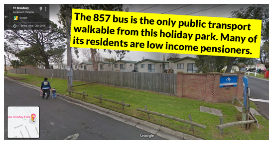
Areas around Melton and Pakenham townships, also growth areas, have seen much less love for buses. Hence they present significant opportunity for improved routes and timetables. Even the opening of the new station at Cardinia Road in 2012 was insufficient to trigger a bus revamp. Subsequent spending has been all about park & ride. Hence we still have unreformed bus routes like the 925 that stop just short of the station, requiring significant backtracking for the hardy few willing to use it. Other local bus issues are mapped below: 


Network reform challenges

So much for the problems. What about some solutions?

I described an extended and upgraded Route 928, south of the railway, last year. Hence today I'll concentrate on north side bus network reform. But not exclusively. 

Pakenham comprises three main east-west corridors. Two road and one rail. All enable transport along them but present substantial walkability access barriers across. The extent of this depends on the choice of corridor. For instance limited access freeways and at-grade railways with few crossings are least permeable. 

Inner suburbs like Northcote and Brunswick, and even outer (but old) suburbs like Chelsea were built with many crossing points across their railways. Back then walking was considered essential transport, not just an optional recreation. Hence it was embodied in the transport system. We were also good at building bridges (numerous but narrow) so that rivers and creeks did not much hinder access. 

Today's designers take 80 - 100 km/h driving rather than 4-5 km/h walking as the norm. Bridges are rarer but wider. Human scale considerations invariably get ignored for new freeway and railway alignments, which now impose almost as much severance as rivers. 

Even if the railway alignment is old, such as it is to Pakenham, if newer suburbs sprout up around it then only a few new crossings are put in. Generally these are for coarse road grids or near station precincts. Away from these there will be large gaps of several times the maximum (say 400m) needed for a permeable community. This is a particular concern given the increased density we are now building outer suburbs as it locks them into car dependence even for local trips.  


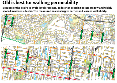
Limited permeability can shape bus network access. While we normally think of buses crossing and feeding rather than paralleling trains, Pakenham's wide spacing of stations means that buses do need to parallel the line and may run near it. Impermeable railways or roads can compromise bus coverage and mean that people have less choice of route than they should. This is a particular consideration here as buses are hourly or worse. 
 

What other considerations would shape the local network? There are no major destinations significantly north and south of Pakenham for a long long way. But the corridor is about 4 or so kilometres from north to south with Princes Hwy and the railway being roughly down the middle. That is poor for walking but may be OK for biking if there were good off-road paths (which there aren't). Buses are thus necessary, with most routes joining the widely spaced stations on the Pakenham line and running parallel to the line north or south of it to pick up residential and other coverage. 

This is more easily said than done. Unlike a greenfields development, Pakenham was built around a long established centre with growth over 40 or more years. Road alignments may not have anticipated the continuous growth of suburbia. Bridges may remain unbuilt and estates may not connect with each other. It may be difficult to route buses that neither leave large areas unserved nor inefficiently overlap others. The map below shows some of the challenges. 


A revised network

The above challenges means that, unlike in some other areas, a new network doesn't automatically seem to draw itself. Despite routes being indirect a new network is unlikely to be practical without new buses being bought to improve coverage and frequency since the latter is currently so low (hourly or worse). 

Pakenham, unlike Wyndham, has a single tier bus network. That is all routes are similarly infrequent. The big change in the Brimbank 2014 and Wyndham 2015 reforms was to introduce a two tier network with some routes operating every 20 minutes, preferably seven days per week. Other routes would typically operate every 40 minutes, though some have a 20 minute peak frequency. 

What might such a network look like for Pakenham? We already have the train with services typically every 20 minutes. But stations are widely spaced so the vast majority only get an hourly bus that might not even run to the nearest station. 

Despite being walking hostile in parts, Princes Hwy looks the obvious corridor for the area's first main bus corridor with many destinations along it. Much of it has the 926 which is the area's most productive bus route. However the 926 veers off Princes Hwy in two places between Cardinia Rd and Pakenham. This together with its hourly frequency makes the 926 more a hybrid local/trunk route rather than a frequent and direct main route. This may have been appropriate in the past but growth means that it is not so now. A simpler network would likely include the 926 sticking to Princes Hwy with another route to provide 'mop up' local coverage between at least Cardinia Rd and Pakenham. 

That's the north side. On the south side could be an upgraded and extended 928, as discussed last year. The path is less defined than Princes Hwy but it would still be relatively direct and provide substantial access to a semi-frequent service. 

A concept map is below. 

Note that local routes are concepts only and one or two more may be required for acceptable coverage.  Though not clockface an off-peak frequency of 40 min would provide greater travel flexibility than the current hourly service. Peak service might be in the 20 to 30 minute range, ie 2 or 3 times better than now. As the area develops and areas around Officer fill in some local route may extend to destinations such as Berwick and Narre Warren to provide better access to regional scale education, hospitals and shopping in that area.  

Stage One

The first stage lays the groundwork for a two tier network and addresses the silliness of the 925 stopping short of its nearest station.  The centrepiece is the reformed 926 which I've called the 930. This becomes the top tier route in the area, running along Princes Hwy. The 926 survives as a local route operating along its existing alignment between Pakenham and Cardinia Rd with the option of an extension north of Princes Hwy to the Kenneth Rd area if run time allows. No stops would be removed except for near the 925 terminus (which would gain an alternative nearby). 


Route 926's scheduled run time is 45 to 50 minutes, permitting the existing hourly service with two buses. If shortening the route reduces the run time to under 40 minutes then the two buses could allow a frequency increase to every 45 minutes with those two buses on the 930 mapped above. 45 minutes is neither clockface nor does it mesh with 20 minute trains. A 40 minute frequency is not clockface, still insufficient for a main route but could mesh with the existing 20 minute train service. If run time is not sufficiently below 40 minutes to allow this, there may be scope to interline with other routes at Pakenham or Fountain Gate. 

Upgrading the 930 to a 'Useful Network' route every 20 minutes would be desirable. Three extra buses should comfortably enable this provided that the streamlined and more direct highway route is adopted.

Whatever service level is chosen with the 926, one extra buses will be needed for this new local-only route. Depending on whether the added coverage at Kenneth Rd is provided this could enable a 40 or 60 minute frequency. Not good but the same as or better than other local routes. 

The main loss is that some on the shortened 926 will lose their one seat ride to Fountain Gate. However some will be walking distance of Princes Hwy where the 930 would offer a more frequent service. If this is an issue options could include careful scheduling to optimise 926/930 connections and/or backtracking the new 926 into Cardinia Rd station (where interchange to other routes would be possible). 

Stage Two

This stage concentrates on routes north of Pakenham Station. It is a bit of a tangled mess, partly due to an unhelpfully indirect road network with too few junctions. You might notice how indirect the 927 and 929 were. The 929 also has a unidirectional loop at the end and a dog-leg just out of Pakenham. 


The map below is an attempt to improve directness. Sometimes making one route more direct results in another becoming less direct. However the less direct route may be more local in character or have other more direct routes within walking distance of much of it. 

When the 925 started there was no station at Cardinia Rd. When the station was built the bus wasn't extended to it. Stage 1 above makes that extension. An extension, particularly in the city-bound direction, makes high directness in the outbound direction towards a station less critical.

Hence the changes in Stage 2. Here I've swapped the 925 and 927 to make the latter more direct. This helps those in the area where the 927 provides the only service within walking distance.  A further straightening of the 927 on the map has routed it via more of Ahern Rd rather than Eagle Dr. There could be scope for 927 to be made even more direct but this would route it further away from Pakenham Secondary. 

The 929 has had a kink added in its north-west portion to throw some coverage to the area east of Waterside Drive. Strictly speaking this should go further east but the road layout is unhelpful for good bus coverage. 

You will notice the double arrow. The idea here is that arriving Route 929 buses would form inbound 927 trips and vice versa. Thus passengers living near the northern part of the 929 could board a 927 at Pakenham and eventually get home in less time than it takes to wait for the next 929. This has the effect of increasing frequency. Also all of 929 would become bidirectional. The main trade-off is that parts of Army Rd would have only the infrequent 840. 
 

By this time the 930 should be a 20 minute service all day. If not already done so the local routes might be every 40 minutes off-peak with a peak service better than that. Offsetting departures of the 927 and 929 (at least in the peak direction) should enable higher combined frequencies for some.   

Stage Three

This does nothing to existing routes except to shorten 926 to finish at Cardinia Rd station. This is replaced by a new route 924. It's a highly indirect coverage mop-up route. No one would ride it end-to-end. But it provides some new north side coverage, connects people to Pakenham Secondary and to the currently unserved business park in the south. 


Conclusion

Some new networks I draw I really like. This is not one of them. It still looks too indirect and, apart from the 930, looks too complex. Admittedly a lot is due to the area's disjointed road network. But not all. Not all coverage gaps are filled and I haven't discussed the new Pakenham East precinct (which is getting a station). If you have other ideas please leave them in the comments below. 


Tuesday, October 26, 2021

Timetable Tuesday #139: The part industrial, part residential 857 bus

It tries to do a lot of things but does none very well. That could be a summary of the 857 bus between Dandenong and Chelsea. Traversing industrial, green-wedge and suburban residential in Melbourne's south-east, it's one of those bus routes that has been there for years with little reform. If you ever wanted a single bus route to explain why many Melburnians don't ride buses, the 857 presents one of our best (or worst) examples.  

Route description

The PTV website depicts the 857 as below. 


The main route starts from Dandenong station, runs due south via the industrial area, then via green wedge areas, paralleling Eastlink. It then turns right, running past the sewage farm on Thompson Rd, at which point it overlaps the recently extended 833 from Frankston/Carrum Downs. After crossing the Mornington Peninsula Freeway it heads south, snaking through the residential area of Patterson Lakes. It's the only bus in the Gladesville Bvd area. 

After that it gets within about 200 metres of Carrum Station. However its passengers are denied an easy change. Instead they need to be patient, having to remain on the bus for a 1km dog-leg south via Whatley St and Church Rd. This gets them to about 50 metres from where they were before. Then the bus turns to feed trains at the newly rebuilt Carrum station. 

From Carrum the bus runs north to Chelsea via Station St. The new Karrum Karrum Bridge means it no longer needs to cross over to Nepean Hwy, saving some time (and two crossings of the railway). You can compare old and new alignments on the PTV network maps below. 

This is possible because updating local area maps often requires manually editing multiple overlapping local area maps. In this instance PTV forgot to update the Greater Dandenong map when it updated the Kingston map. Hence the Greater Dandenong map still shows the old 857 alignment and Carrum station location from 2 years ago. The Kingston map is current in this regard.

However the Department of Transport really can't take a trick as both maps haven't been accurate since the special 970 Night bus was deleted in favour of upgrades on the regular route 833 a month ago. They do know about this as the Frankston local area map (which also covers Carrum) did get correctly updated and there's an item on their website about it. If you think something looks wrong on a PTV map it probably is. But you might find it's correct on another map as DoT has massive problems with information consistency and version control.   

Anyway, back to the 857. The last leg serves residential catchment, including parts of Chelsea slightly beyond walking distance of either it or Bonbeach station. This area includes a lot of 1960s-70s era 2 bedroom villa units on streets off Fowler popular with retired folk. Also in the area are retirement homes and the Chelsea Holiday Park, popular with low income pensioners. The 857 is the only walkable public transport for these residents. 

A better view of the 857 is on the network map below. Its catchment can be roughly described (starting at Dandenong) as 1/3 industrial, 1/3 empty and 1/3 residential. The dotted lines show some deviations. That near Dandenong is for a small residential pocket while another at the Patterson Lakes end starts from Chelsea Heights. 


The 857 performs several functions. These can be summarised as: 

* Dandenong Station to Dandenong South industrial area (though less since the overlapping 890 started)
* Dandenong to Dandenong south off-peak shopper route
* Train feeder in Chelsea, Carrum and Patterson Lakes areas
* Local shopper connection between Chelsea and Patterson Lakes
* Longer distance shopper connection from Chelsea area to Dandenong
* Some school access functions 

Electoral districts served include: Dandenong (Gabrielle Williams MP), Carrum (Sonya Kilkenny MP) and the southern extremity of Mordialloc (Tim Richardson MP). All are currently held by Labor but the last two were marginal 'swing seats' before the 2018 election. 

Timetable

The 857 is a daytime only route that runs 5 1/2 days per week. It is one of several bus routes that cling to the old Monday to Saturday morning regime that the rest of Melbourne ditched over 30 years ago and many buses abandoned over 10 years ago. 

It's basic frequency is roughly hourly interpeak and on Saturdays. Early afternoon intervals for the entire route are more like 90 minutes. To give you an idea of this, the last four trips from Chelsea leave at 2:28, 3:55, 5:25 and 6:20pm. The latter means that those who finish work much after 5pm in the CBD arrive at Chelsea or Carrum too late for the bus to take them home. 

A higher peak frequency between Dandenong South and Dandenong is provided with short outbound trips in the morning and inbound trips in the afternoon. Frequency is roughly every 20 or 30 minutes. The first departure from Dandenong at 5:05am reflects the early start at many industries. 

A couple of off-peak trips each way deviate via Morwell Av in Dandenong South to provide a shopper connection for an otherwise isolated low income residential pocket including Albanian and Russian communities. An 8am trip leaves Chelsea Heights to end up at Chelsea via Patterson Lakes. These are the dotted lines on the map before. 

Saturday service is hourly over a three to four hour span in the morning. This can enable short local shopping trips, such as between Patterson Lakes and Chelsea. Longer travel, such as a trip to Dandenong Markets, though is harder. For example the first departure from Chelsea arrives at 10:28am. When you add walk time only a short look around is possible before one must be back at the station for the last bus leaving Dandenong at 11:41am. Similar comments apply for those relying on the 857 for other Saturday trips involving a change to the train at Carrum or Chelsea, eg to Frankston. 


The 857 didn't used to have public holiday service. However several years back it and other routes got an upgrade so it runs on those public holidays that a Saturday timetable operates (as per the standard pattern). The message doesn't appear to have go through to the PTV website though, which on the upcoming Cup Day holiday, is showing the 857 with most of its trips missing in one direction.

History

What we now know as the 857 can trace its history back more than 70 years with a route that ran from Dandenong to Mordialloc with an alteration to terminate at Chelsea in 1947.  It took pretty much its current form in 1987, including operation via Patterson Lakes and Carrum before reaching Chelsea. Its old alignment can be viewed on these maps. The changes incorporated short 860-series Chelsea area only routes into parts of longer routes like 857 and 888/889. Part of that was undone about 10 years ago when the more direct 902 orbital SmartBus was created with unique parts of the 888/889 hived off to form the almost circular 858 from Edithvale to Aspendale Gardens via Chelsea. 

Short trips between Dandenong and the Dandenong South industrial area were added some years ago. However despite its residential catchment the route was not included in the 'minimum standards' upgrades introduced to many routes from 2006. The 2009 Bayside/Kingston area bus network review recommended reforming it to make it a direct Dandenong to Carrum service but this, like most review recommendations, did not proceed. 

Patronage

In late 2018 Route 857 attracted 22 boardings per service hour on weekdays, which is about average for buses in Melbourne. This is surprisingly good given that portions of the route overlaps others while much of its middle section traverses empty 'green wedge' areas. Saturday usage, at 9 boardings per bus service hour, is much lower, possibly due to its restricted operating hours that make return trips difficult.

Interestingly, while the 857 hasn't been reformed lately, more of it has been overlapped by other routes offering higher service levels. These include the 890 in Dandenong South and the 833 in parts of Patterson Lakes. This might have undermined 857's usage on common portions. 

Conclusion

That's enough for the quirky 857. The route serves a lot of roles but it's complex, indirect and arguably underserviced in places. What's your thoughts on it? Are there ways its route or timetable could be improved? Would removing from Whatley St speed travel or running via Scotch Pde improve coverage? Should other surrounding routes be reformed too? And what about longer hours and Saturday afternoon and even Sunday service? Comments are invited and can be left below. 


Other Timetable Tuesday items


Friday, October 22, 2021

What if we joined Melbourne's rail lines?

A short hypothetical today. 

Our rail network is one of the most radial in the world. Leaving aside City Loop variations, out of our 220 plus suburban stations there is just one (Laverton) where you can go to the CBD via a different corridor. And that difference is slight (Altona Loop or not) and is only available on weekdays. Our proposed Suburban Rail Loop is an ambitious and expensive way to overcome that (albeit on one orbital corridor only). 

Sydney's rail network is very different. Whereas even our shorter lines (Alamein, Sandringham, Glen Waverley, Upfield) simply finish, in Sydney they generally end at a station on one of the longer lines. Thus there are far more suburban rail junctions that accommodate trains from multiple directions there than here. We have suburban rail junctions too (eg Footscray, Newport, Camberwell, Clifton Hill, Caulfield, Dandenong, Ringwood) but in all cases the lines fan out, never to meet again. 

Below is a hypothetical augmentation of Melbourne's rail network. Lines have had extensions to connect to another line, typically the nearest longer line. They range from connections you'd see in official plans to something so geometrically terrible that you would never do. There are a total of seven joins - click on the map below for a better view. 


Discussion of each connection option

1. Werribee - Wyndham Vale. At least on the above not to scale map, this is the shortest link of the lot. It involves extended electrification and likely a new station at Black Forest Rd. As well as providing new coverage in a growth area it restores a rail - rail connection between Werribee and Geelong, provides some capacity relief for Wyndham Vale and provides some extra network robustness if trains in one line inward from Wyndham Vale cannot run. This is by far the most likely connection to go ahead with it being mooted in the government's own Western Rail Plan. The City of Wyndham has also advocated for it

2. Flemington Racecourse - Albion. Unlike the above this is one is very likely to sit in the untouched bottom drawer marked 'fantasy lines'. There's no clear rail corridor and there'd likely be significant overhead or tunnelling work (including over or under the Maribyrnong River one or more times). A very direct alignment might be under Ballarat Rd but there'd likely be a wish to operate further north-west to serve Highpoint (as mentioned here). It could even be a new corridor serving Melbourne Airport (as some have suggested). f this north-west alignment is continued it could finish at Melbourne Airport. Such an option has been scotched by the intention instead to route airport trains via Sunshine. But this concept could still have the extended racecourse line finishing at a junction station like one potentially at Keilor East, though the map above has it running to Albion. Strictly hypothetical. 

3. Upfield - Roxburgh Park. Here is the second (and I think last) one that is rooted in real proposals. A corridor already exists so costs would be low. And there's been support from people like Rail Futures and the Upfield Transport Alliance. Because Roxburgh Park is only one station from the line's terminus at Craigieburn, the connectivity isn't as good as (say) an east-west connection like the Suburban Rail Loop (thin grey line) proposes. However, if accompanied by amplification, it could provide some capacity relief for a combined regional and Metro line to one of Melbourne's major growth areas to the north. Plus it could provide some long needed frequency upgrades for the Upfield line which is infrequent, even in peaks. Again this could well happen.  

4. Alamein - East Malvern - Caulfield. This would not be a trivial engineering project despite its shortness. However what it lacks in extra track kilometres it makes up in network connectivity. Nowhere else on the network do so many lines carrying so many people come so close together at so far from the CBD. A rail Caulfield - Camberwell connection would connect six of Melbourne's lines serving almost the entire east and south-east. It would strengthen Caulfield as a hub and likely improve airport connectivity given the stated intention of running airport services through to Caulfield. And so many other trips in the east and south-east would become practical by rail. I love this concept as it would give the south-east a second orbital with only a few extra kilometres of track. However I don't think it's ever been part of any serious proposal, with others preferring other extension alignments such as via Chadstone, Huntingdale and then Monash and Rowville. Hence it's another hypothetical. 

5. Glen Waverley - Ferntree Gully. This is really an extension of the radial Glen Waverley line so is more radial than circumferential. Some proposals for rail to Knox (including a PTUA one from the '90s) had its rail extending from Glen Waverley rather than Huntingdale. This option missed Monash University Clayton but may have balanced capacity as the Glen Waverley line is much quieter than Dandenong. Huntingdale has a bit of history; it was the branching off point for the 1969 Transport Plan connection to Ferntree Gully that was revived in a soon abandoned 1980s Steve Crabb promise. Politicians of all colours have raised expectations of rail to the Knox area for decades with nothing happening. This concept is likely to meet a similar fate.  

6. Cranbourne - Pakenham. Some extension to the Clyde area is desirable to take in development but otherwise the geometry is quite poor. The map has it running to Pakenham, though maybe Officer would be a better choice if that develops as a large centre. The 1969 plan had a different take, with a branch off at Lyndhurst looping around to Frankston. Like previously discussed areas in the north the outer south-east is a fast developing area, with new housing increasingly stretching further and further way either the Cranbourne or Pakenham lines as it spreads east from Clyde North and beyond. One can certainly see an extension south-east to Clyde, aided by current upgrade work for the Cranbourne line, but an extension to join any other line is most unlikely. 

7. Sandringham - Southland. I've avoided any extensions on the SRL alignment. Hence this qualifies as the SRL starts at Southland, not Sandringham. It's not a growth corridor and a good bus along Bay Rd will likely suit most transport needs and capacity for a long while. On the other hand if Southland becomes a huge centre (much bigger than now) then there might be more than just casual discussion (like this Reddit thread) on a high capacity Sandringham connection. 

Conclusion

A mix of 'no brainer' and outlandish ideas have been presented for better connecting our rail network. Comments and ideas, impractical or otherwise are invited and can be left below. As further reading, enjoy this Wikipedia entry on various proposed extensions

Tuesday, October 19, 2021

Timetable Tuesday #138: Melbourne's 'Rapid Running' bus trial - can it work?


One of the initiatives in Victoria's Bus Plan, released back in June (and reviewed here), was a 'rapid running' trial on certain bus routes. 

The Minister's foreword states:

Rapid Running is being successfully trialled on Route 246 and up to 10 more routes will be trialled before the end of the year.

So what is 'rapid running'? 

It's a jazzier term for what is more often called 'headway management' or 'frequency timetables'. 

Why would you do it? 

Consider a passenger making a short trip on a bus from A to B. They board the bus and, a short time later, the bus stops. Apparently it's running early and needs to wait for the timetable to catch up. If traffic conditions are light or scheduling is loose the bus could easily sit for five minutes while it waits for its scheduled departure time. 


That's not a good experience as the wait is a large proportion of the total travel time. And time not moving is perceived as longer than time in motion, even if slowly, so it seems worse. 

'Rapid running' aims to keep the bus moving for more of the time. It shifts the emphasis from exact times to maintaining a specified headway so buses no longer need to stop if ahead of time. Passengers making short trips like A to B might find them quicker as time point waits are removed. 


The three highs of 'rapid running'

Headway management is potentially useful on busy roads where varying traffic conditions greatly affect bus run times. Such variability makes it difficult to write a timetable that will be adhered to.  

However at least three conditions must be met for the trial to succeed. These include: 

1. High Frequency. You would never headway manage routes not frequent enough to be regarded by users as 'turn up and go'. Infrequent buses need fixed timetables, preferably timed with the trains they feed (especially if these are also infrequent). Waiting time is perceived as longer than time in the bus (even if stopped at a time point) so unless there's enough buses to run short headways, 'rapid running' is more trouble than it's worth.  

How frequent must a bus be before you'd consider it suitable for headway management? Expert opinions vary but there seems agreement that you not do it unless services were every 10 minutes or better.  


Based on a 10 minute cut-off, where are Melbourne's frequent bus routes? 

Unlike other cities of our size we have only a handful, even if you look at weekday timetables only. They're labelled below.  

Frequent corridors formed by multiple routes are harder to rapidly run (at least in both directions) so are shown but not labelled. 


Our lack of frequent routes makes finding even 'up to the ten more' suggested in the Minister's Bus Plan preface a tough ask. Now on to the remaining two conditions. 

2. High technical, operational and cultural readiness on the part of the bus operator and contracting agency. A quality 'rapid running' operation with even intervals between buses requires more close monitoring and responding via a control centre using traffic data from the road management agency. That can then be used to provide information feedback to drivers and an ability to vary the number of buses on a route to maintain headway under busy or quiet traffic conditions. Passenger counters on buses might enable better responsiveness to surges in patronage, but again there needs to be the ability and resources to respond quickly.

Ideally bus data would also flow back the other way, to the traffic authority, so that traffic signal phasing gives buses a good run. This data revolution has implications for bus management practices from depot locations to staff rostering, operator payments and performance monitoring, management and penalties.  

3. High passenger trust. Take away a timetable with specific times and passengers will scream. Especially if it's a low-trust system where transport departments are seen as distant from passenger concerns or not really in control. The following can lower trust in a bus network: 

a. Services are run by poor quality operators (like the soon to exit Transdev Melbourne about 4 or 5 years ago with its dirty, cancelled and unmaintained buses) without effective oversight from transport bureaucrats (who can't be too tough in case they damage their prospects for jobs elsewhere in the industry, including at those they previously regulated). 

b. 'Rapid running' is introduced simultaneously with unpopular changes like privatisation and radical network reform, especially if it removes coverage (like what was proposed then scrapped in Adelaide last year). It is better to introduce it separately and gradually, like we are doing. And explain it well.  

c. Real-time information is either missing or unreliable. Seeing a bus show up as coming, not arrive and then pass after you have given up waiting really shakes faith in the network. Real time information systems need to be at least an order of magnitude more reliable than the system they're monitoring to win user trust. For buses in Melbourne we're not there yet! 

d. There is no public operational performance reporting or accountability. For a long time we reported train, tram but not bus service delivery in Track Record. Buses with fixed timetables are now reported too. However there still needs to be a way to report performance of 'rapid running' bus routes. For a route with a nominal headway of 10 minutes, reporting could highlight instances where fewer than 6 trips per hour run and gaps between buses exceed (say) 12 minutes. 

e. There is a passive official acceptance that bus passengers come near last in the transport system, with few exclusive lanes and services cancelled or diverted when car traffic volumes prevent buses from moving. 


Another example of bus' low status is what happens if services are disrupted. If Metro train services are suspended replacement buses are brought in. Indeed contingency arrangements exist with bus companies to do just that. Whereas if a bus operator can't run its buses then there are rarely arrangements for others to take over, so trips just don't run with 30 to 60 minute gaps, even on major routes. The main recent exception was during Transdev's fleet maintenance crisis of 2017 where other operators' buses stepped in to run Transdev routes. 

'Rapid running' could be described as a 'social contract' between bus operator and passenger. We take away your timetables in exchange for running a frequent service and better responding to traffic conditions. Its acceptance depends on passenger trust that needs to be earned beforehand.  

I think it would be fair to say that generally Melbourne has a low to moderate trust bus system, although parts, like the most university shuttles, have much higher reputations. That's important because if trust is high it is likely easier to win (even if grudging) acceptance of bus reform like but not limited to 'rapid running'. 

Which routes are getting rapid running?

The first route we knew about to get rapid running was the 246 down Punt Rd/Hoddle St. This is a popular route along one of inner-Melbourne's busiest road. It is one of just two 7 day routes to feature a 10 minute interpeak service (the other is the 402 across from Footscray). 

'Rapid Running' for the 246 commenced in March 2021, before the Bus Plan came out. 

There were enough results by June for the minister to be able to say it had been a success. 

A little later the PTV website page advising the 246 trial was updated with other routes listed for 'testing frequency timetables'. These were described as 'selected high frequency bus routes'. 

Timetables would be removed from stops but the buses would continue to follow timetables (unlike the 246). Passengers would be surveyed on what they thought, with the possibility raised that the routes could change to a 'turn up and go' service like the 246. 


Let's go through these routes, starting with the most frequent first. 

* The 401 Melbourne and 601 Monash are both university shuttles that are already very frequent (eg up to every 3 or 4 min). All users would definitely be using them as a turn-up-and go service right now. These are exactly the sort of services that you'd have frequency timetables for with their short lengths likely making management easier. 

* 301 is another university shuttle (Reservoir - La Trobe). This runs every 10 minutes. However the train service it was designed to connect to at Reservoir is only every 20 minutes off-peak. That makes arrival time important. Even if the bus is frequent you still need to have scheduled times and fixed timetables to avoid the possibility of just missed trains. Hence I'm wary about 'rapid running' on this route despite its frequency.   

* 402 is the only other single seven day route in Melbourne that's every 10 minutes. Like the 246 it runs seven days but less frequently on weekends and with shorter operating hours. And it can similarly be described as being of moderate length, unlike the short university shuttles discussed thus far. Length is important because in a few lucky cases there may be times where you might be able to save a bus or boost frequency if run times are consistently shorter than the timetable allows. This makes it the next  most suitable route for a trial after the 246. 

* 250/251 are both every 20 minutes each. These provide a 10 minute combined service through Melbourne's inner north. This is why only southbound trips would have their timetables removed. This different presentation of information may confuse passengers since northbound trips will retain timetables at stops and the same passengers will likely be using both.

* 513 to Glenroy. This absolutely should not be a part of the trial even though it serves busy Bell Street. Not only because it's a long and confusing route with alternating paths in the east. The main reason to object is it's just not frequent enough. The PTV list above claims 15 minute frequencies, but this is wrong; the 513 operates only every 20 minutes, a frequency that definitely needs a timetable. The 513 should be removed from the trial until the route is reformed and services upgraded. 

What wasn't mentioned? Most conspicuous is the other frequent university shuttle, the 202 from Parkville to Victoria Park. Its 10 minute frequency is like LaTrobe's 301 and, beyond Clifton Hill, the trains it connects to are every 20 minutes interpeak. It only started on September 20, so maybe they wanted to try a regular timetable first. 

Something that would have disrupted 'rapid running' trials on routes run by Transdev (including the 246) is that reduced driver availability due to COVID has seen mass cancellations with some services slashed by 50% or more. With low frequencies, even on some of our main bus routes, you absolutely have to have fixed timetables and 'rapid running' is out of the question. 

Other possibilities

If things go well and the trials were a success, where else would you consider it? 

If the lessened legibility of doing it in one direction only on the inner portion of a corridor of routes is acceptable then two other potential corridors include the 905/906/907 from Collingwood into the city and the 200/207 from Kew into the city. These provide approximately a combined 5 and 10 minute service respectively. 

Another possibility is peak service on the routes with intensive peaks eg some of the 900-series SmartBuses (900, part 903, 905, 906, 907, 908) and possibly others like the 220, 234 and 465. 900, with its two companies running the route, would be operationally difficult if not impossible. Peak buses serving Fishermans Bend might also be close to the 10 minute frequency required. 

Key to further expansion is Sydney-style bus network reform to simplify services and increase the number of routes operating every 10 minutes or better. This is especially if 'rapid running' can reduce dwell time so that headways can be got down to 8 or 9 minutes. It should be emphasised though that rapid running should never be regarded as a substitute for useful but politically difficult initiatives such as bus priority and segregation on key corridors. 

The sort of short to medium distance and high patronage potential routes that could justify, high priority, 5 - 10 minute frequencies and rapid running might include the likes of:  

* 201 Upgraded Box Hill - Deakin Uni shuttle
* 220 Megabus along Ballarat Rd between Sunshine, Footscray and CBD
* 406 Megabus between Footscray, VU and Highpoint (with extension & other reform)
* 733 SRL SmartBus between Box Hill, Mt Waverley, Monash, Clayton, Southland, Sandringham
* 904 Megabus between Coburg, Preston, Northland and Heidelberg
* 900 Megabus between Caulfield, Chadstone, Monash and Stud Park
* 907 Megabus between City, Doncaster and Mitcham

These included upgraded regular routes and or significant reform to other routes. This lowers the cost of providing the desired 10 minute or better service needed for 'rapid running'. This needs to be done before 'rapid running' is attempted as all are currently only every 15 - 30 minutes interpeak. 

More ambitious upgrades, again with new 10 min or better off-peak service, might include:

* New 620 SmartBus Caulfield - La Trobe University
* 901 SmartBus between Ringwood, Dandenong and Frankston
* 902 SmartBus between Melbourne Airport, Greensborough, Doncaster, Springvale and Chelsea
* 903 SmartBus between La Trobe Uni, Heidelberg, Doncaster, Box Hill, Chadstone and Mentone
* New Wollert - Northern Hospital - Epping - Plenty Rd bus wormhole

These are mostly new (620, Wollert) or realigned (902, 903) high patronage potential bus routes. Current frequencies on these corridors are from 15 to 40 minutes so upgrades would involve significant extra resources. However some would be clawed back by reducing route overlaps, particularly in north-eastern Melbourne, where frequencies are out of kilter with usage. Also reform would provide a substantial BRT style network for much of middle and outer Melbourne. The success of these longer routes (especially the split orbitals) likely depends more on the priority that can be accorded (to enable faster and more reliable timetables) than band-aids like 'rapid running' alone. 

Conclusion 

Rapid running is a 'big city' bus idea. There may be a case for it on some routes in Melbourne. However we don't have enough of a frequent 'big city' bus network to make it widely applicable.  

A much larger scale rapid-running roll-out requires us to develop a frequent 'top tier' bus network first. Several high patronage potential corridors have been suggested for this. 

'Rapid running' is not a cure-all. The real game-changers for buses are simplified, more frequent networks and 7-day bus priority to enable shorter and more reliable journey times. This would increase passenger boardings per kilometre and free up resources for further service upgrades and frequency improvements.

Your thoughts on all this are appreciated. Have you tried the 246 or other routes lately? What have been your experiences? Would you rather faster time in the bus or set timetables at stops? Or maybe you think some routes should or should not adopt rapid running in preference to those discussed. Please leave any comments below. 


Friday, October 15, 2021

UN 109: Fixing Maribyrnong public transport's black hole

Want the worst of both worlds in a suburb? Combine high-rise with high car dependence. Here the sacrifices made on outdoor space and privacy are not offset by superior accessibility. In some cases facilities may be physically close but walkability is compromised by wide fast roads and seas of parking one must cross to go anywhere. 

Melbourne is building such developments apace. We have no enforced coverage, service or speed standards for public transport for any housing development, let alone that which is high density. And we're not great with active transport either. 

While often derided by developer interests and their urbanist cheerleaders as 'NIMBYs', opponents of high rise in poorly serviced areas are absolutely right given our track record of not backing density with service. 

Even the 2006 program of minimum service levels for buses (ie seven day service, hourly to 9pm) missed areas not then considered residential. Some of these areas now are but only rarely have had bus timetables updated to suit. 

Many large scale or dense developments have proceeded despite lacking good transit access and service, even in inner or middle suburbs. A few examples include:

*Alphington Paper Mill site (weekday buses half-hourly and no weekend service - see 546)
* M-City Clayton on Princes Hwy (two infrequent bus routes, only one is seven days)
* Kodak site housing at Coburg North (served only by half-hourly six day per week 526)
* Factory and retail outlets such as near and behind Moorabbin Airport (828 infrequent weekends)
* New Quay Docklands (yes it has trams but speed and geometry are poor) 

Fishermans Bend threatens to add itself to the above if much more gets built there before Melbourne Metro 2. 

Dense places like Moonee Ponds have both trains and trams but one must choose between speed (trains) and frequency (trams). No mode offers both because of our habit of running trains infrequently off-peak and accepting slow speeds on trams. Not only that but one of the latter, the 82 tram with 20 minute gaps on weekdays, offers neither speed nor frequency. 


Current connectivity from Maribyrnong

Mention of the 82 tram brings us to what's near its middle. Highpoint Shopping Centre. Not only that but a growing forest of apartments as industrial landholders sell or develop. More people means more cars and continual gridlock, unless transport other than driving offers a reasonable alternative. 

A quick summary of current public transport offerings in Maribyrnong and surrounds is as follows: 

Tram 57: Frequent but slow to CBD, with am peak time to Flinders St approaching 50 minutes. May be possible to save some time by changing to train at Ascot Vale but off-peak trains only every 20 - 40 min. Physical tram/train interchange not well provided for. 

Tram 82: Operates to Moonee Ponds and Footscray. Less direct than most tram routes. Least frequent tram in Melbourne with 20 min frequency off-peak weekdays. This is a lesser service than in the 1980s when the area was far less developed. Requires a change at Footscray for CBD travel. 

Bus 223: Operates to Footscray and then on to Yarraville.  A remnant of the Footscray tram system it offers no unique coverage as it is largely overlapped by other routes including the 82 tram and buses 406 and 472. Its Monday to Saturday 15 minute frequency doesn't evenly mesh with trains at Footscray (either every 10 or 20 min) yet is not enough to be considered turn-up-and-go for short trips in dense areas such as this. Poorly used at the Yarraville end. 

Bus 406: Footscray to Keilor East bus via Victoria University. Indirect between there and Highpoint with a different path north and southbound. High usage not reflected in its low service levels. Every 20 minutes Monday to Saturday, but only every 40 min Sundays with finish approximately 9pm most nights. However route has recently gained 24/7 operation on weekends under Night Bus reform.  

Bus 407: A minor coverage bus route that operates from Highpoint to East Keilor. Limited hours and lacks seven day service. Useful to consider if reforming the 406. 

Bus 409: Infrequent and indirect Yarraville - Footscray - Highpoint bus providing local coverage for Edgewater Estate. May however come into play if straightening and simplifying other routes like the 406. 

To summarise, the main routes that connect Maribyrnong with the outside world are the 57 and 82 trams and the 223 and 406 buses. None offer fast turn-up-and-go access from a densifying area. Issues are summarised on the map below. 


Some have suggested heavy rail options, including having Highpoint as a stop on an airport rail line. This alignment however has been rejected by the state government with the proposed airport rail instead to operate via Sunshine. Here I will only discuss shorter term measures, such as service improvements on existing lines and bus network reform. 

Six steps to better Maribyrnong transport access 

Here's how you might make Maribyrnong less of a transport 'black hole'. More detail under the map. 


1. 406 Footscray - Highpoint Megabus. This is a consolidation of bus resources from routes 223 and 406 to create a single, simple and frequent route between Footscray, VU and Highpoint. Buses could run every 10 minutes seven days per week to provide a turn-up-and-go service connecting evenly with trains at Footscray. Maximum waits late at night would be 20 minutes, timed to connect with Werribee line trains at Footscray (also every 20 minutes). Route 409 would be modified (and potentially upgraded) to retain coverage in the area missed by the straightened 406.  Every second 406 trip would extend to Keilor East or beyond (see later). 

2. New 405 Tottenham - Highpoint bus. A proposed route to give Tottenham station its first feeder bus. This is intended to provide a faster train feeder than existing routes via Footscray. Service could be every 20 minutes or better, especially in the peaks. The route via Ashley St could enable other reform such as a frequent 220 tram-like 'Megabus' down Ballarat Rd in conjunction with reform to Route 410. A side-benefit would be an extra connection to Highpoint for parts of Braybrook and West Footscray. A potential later extension might see the route run south to Yarraville, providing a feeder for another densifying area.  

3. Upgraded 82 tram frequency. First priority would be to boost weekday off-peak service from 20 to 15 minutes, and then to 10 minutes. Evening service could be boosted to 20 minutes with services optimised to meet with Werribee line trains at Footscray and/or Craigieburn line trains at Ascot Vale. 

4. Routing 903 SmartBus via Highpoint. When the SmartBus orbital network was planned it was proposed that there would be a 'blue orbital' that would connect to Highpoint. This never happened. The only SmartBus that made it to the western suburbs was the 903 or 'red orbital'. It overlaps much of the 465 along Buckley Street, missing major destinations between Essendon and Sunshine. The map shows the 903 being rerouted via Highpoint to replace the existing but lower frequency routes 468 and 408 (eastern part). This would improve connectivity to the Craigieburn line at Essendon and through Braybrook to Sunshine. To retain service in the Keilor East area there would be a compensatory extension of Route 406 (to Sunshine), reform of Route 407 and improved operating hours and frequencies on routes such as 406 and 465. More detail here

5. Trains every 10 minutes to Craigieburn and Watergardens. These are the two train lines either side of Maribyrnong. They are amongst the busier lines on the network but off-peak frequencies are only every 20 minutes (weekday interpeak), 30 minutes (night) and 40 minutes (Sunday morning). An upgrade might boost daytime frequency to 10 minutes and night frequency to 20 minutes, such as enjoyed on the Frankston line. This increase would assist connections with the 82 tram at Ascot Vale and the proposed 405 bus at Tottenham. 

6. Upgraded Route 57 tram frequency. Frequency is already good at most times. A key upgrade could be reducing maximum waits from 30 to 20 minutes by boosting Sunday evening service. Later upgrades would reduce maximum waits to 15 and then 10 minutes for more of the day. 

Conclusion

Described have been six upgrades to improve public transport access in fast-developing Maribyrnong. Most involve off-peak upgrades and bus network reform. Once done the area's density and activity fully warrant infrastructure upgrades, for instance tram modernisation and bus speed upgrades including 'bus wormholes' on the major corridors. Comments are invited and can be left below. 


See other Building Melbourne's Useful Network items here


Tuesday, October 12, 2021

Timetable Tuesday #137: Route 546 - The Yarra's north bank bus


Route 546 is a quirky bus route in Melbourne's inner to middle north-east. Running from Heidelberg to Clifton Hill and then to either Melbourne University or Queen Victoria Markets it serves everything from wealthy 'old money' suburbia to densifying clusters of modern apartments. State seats it serves include Richmond (marginal Labor - Richard Wynne), Northcote (marginal Labor - Kat Theophanous)  and Ivanhoe (safe Labor - Anthony Carbines). 

Route 546 received attention lately when one of its stop was removed in conjunction with the introduction of the 202 shuttle. The route almost but not quite runs in to the Melbourne CBD. It has an oddity where peak trips serve Melbourne University and off-peak trips serve Queen Victoria Market. The map below shows its alignment is roughly north-east, between the Hurstbridge line and the Yarra River. 

A view of the 546 in relation to other routes is below. 

Much of it parallels the inner part of the Hurstbridge train line from Clifton Hill to Heidelberg. However it has sufficient unique catchment that at least portions of it justify keeping, especially given density increases along it. It may connect with Parkville station on the Metro Tunnel when that is completed in a few years. 

The 546 has several roles. These include its use as the only buses in parts of Ivanhoe East. It is also the nearest radial public transport for the southern part of Alphington. It also provides a possibility for Mernda and Hurstbridge passengers to change to it at Clifton Hill for a faster trip to Melbourne University. However since the much more frequent 202 started they would now be better off to catch that from Victoria Park. 

Timetable


Bus 546 runs every half hour from about 7am to 7pm Monday to Friday. The route was one of the 50-odd overlooked by the 2006 MOTC plan which delivered 7 day hourly minimum service standards to  many bus routes throughout Melbourne. 

Hence it has no weekend or public holiday service, although there was a Saturday morning service prior to the massive October 1991 service cuts whose axe-marks remain apparent in timetables of three decades later. Some later weeknight trips got added in the 2000s. More recently the route had issues with timetable adherance and run times got extended. 

Apart from the lack of Saturday service, the 546 timetable has some similarities with the 548 (with which parts overlap) and the 549 in basic service level and operating hours. 

Last year I identified the 546 as one of the thirteen bus routes that most deserve Saturday service to be restored or added, largely due to its areas of unique coverage and dense development along it. 


History

The 546 has had some chopping and changing, particularly to its termini at the city end. You can trace its evolution via network maps hosted by BCSV and historic timetables at Krustylink. Termini at various times changed from East Melbourne to Collingwood to Clifton Hill to Melbourne University or Queen Victoria Markets. 

Conclusion

Route 546 is one of those bus routes that has just stagnated despite all the change around it. For example the dense development at Alphington has not spurred a service increase, not even to the 7 day hourly minimum standard service level. On the other hand the portion between Clifton Hill and Melbourne University may see reduced usage due to the 202 providing a more frequent shuttle. Its timetable is living testament to the need for bus service reform in Melbourne to address 30 or more year backlogs as things change around basically stagnant bus services.