Are you being served? Commentary on the service aspects of public transport in Melbourne, Australia. Covers networks, routes, timetables, planning, co-ordination, information, marketing and more.
A different Timetable Tuesday where we venture outside Melbourne to other capitals. And I'm going to ask you to do the work of picking which routes to look at yourself. Still it's an interesting exercise to compare the different emphases in services that different cities have.
A few I've spotted include high 7-day off-peak train frequencies in Sydney and Perth with lower frequencies in Adelaide and Brisbane. On local bus routes Perth has relatively high peak frequencies (every 20 min) but sometimes low (60 min) off-peak frequencies. Brisbane has a sharp BUZ/local route distinction with a small number of premium bus routes running very frequently but a very large number of local routes having the worst of all cities (eg Melbourne-style peak frequencies, Perth-style off-peak frequencies and short operating hours). Sydney meanwhile has more 10 minute frequency routes than anywhere else, although they still tend to be in the more affluent areas.
There are also differences in numbering. Most larger cities use three digit numbering with Adelaide (especially) having a lot of letters. Premium more frequent routes have 900-series numbers in Perth and sometimes also in Melbourne.
If you spot more notable differences please mention them in the comments below.
Streetsblog USA runs an annual competition inviting readers to send in details of their 'sorriest bus stop'. The aim is to call out the contempt that some administrations have for public transit and its passengers and to encourage better design and facilities.
What is a 'sorry bus stop'? I'd encourage you to view some examples. Common elements include lack of shelter, no paths, no way to cross busy roads, no safe place to stand out of the traffic, truck noise, fumes and no information. Imagine having to cross a multi-lane roundabout to reach a pole stuck in a muddy road shoulder and you get the idea. Especially if the bus you're trying to catch is hourly or worse.
It's not just an American thing. Melbourne too has its share of 'sorry stops'. Here's my six picks:
Dohertys Rd, Laverton North (Route 400)
What isn't sorry about this stop (at least when Google drove by last March)? Take your pick. No shelter. No footpath. The continual stream of close-passing trucks splashing mud everywhere. And an inabilty to cross the road. Have a look for yourself here. One hopes improvements here are within scope for the Dohertys Rd upgrade project.
Fullarton Rd near Roberts St, Keilor East (Routes 465 & 476)
Here you have a choice between being sandwiched between traffic and the crash barrier or standing in knee high shrubs between the barrier and a mesh fence. The latter though may be necessary to read the timetable at a straight angle. That can be important given the paper in them can disintegrate into a million pieces under harsh sunlight.
The photos below were taken during a site visit in 2019 but you can pan around for yourself in this more recent street view from December 2020. The stop serves industrial area jobs. And because it's on two routes, service on it is unusually high, with 4.5 buses per hour operating weekday interpeak. Also, as mapped, it is in Transport Minister Ben Carroll's seat of Niddrie.
Beveridge (Route 511)
It's not so much the stops that are sorry here but the service to this fast growing area. The area around these stops is mostly built out. However stops see just a handful of peak trips, with no midday, weekend or evening service. However it's (slightly) better than it was with the service starting with just one trip each direction.
Let's say you wanted to get from Frankston Station to Frankston RSL. This is the sort of trip that ought to be ideal for the bus. After all weekday service on this corridor has been an outstanding one bus every 10 minutes since the Cranbourne area network review in 2016. And, at first glance, the bus stop is opposite the RSL, with only a short walk required.
In practice it's more complicated and the walk to the RSL is two or three times the distance than it should be. A barrier and a fence physically block access at the nearest point. And even if there was, signalised crossing points are a fair way either side.
Police Rd, Mulgrave (Routes 631, 813, 814, 848)
At first sight this residential area stop ticks several boxes for goodness so shouldn't be here. For instance there is a shelter and paths to it. It makes it to this list solely due to its poor access for the >90% of users who would walk from the north. It's located on a busy road with no zebra or signalised crossing anywhere nearby. And it's served by four routes to diverse destinations so could attract significant usage if access was better.
High St Melton (Route 456)
The name of the nearby play centre is possibly a good description for how one must play chicken with high speed traffic to have any hope of reaching this stop on Melton's Route 456. Like Mulgrave's Police Rd stop it has shelter and paths but no fast and safe pedestrian access across the road to reach it. The stop's catchment includes jobs and retail and there's no alternative route or stop nearby. And the large unsignalised roundabout to the east guarantees a continual stream of traffic.
Calder Freeway - Organ Pipes National Park (Route 483)
Freeways typically have bad influences on public transport. They can sap patronage from parallel railways, especially if trains are slow all-stations stoppers at most times (eg Frankston and Glen Waverley lines) or are infrequent (eg V/Lines to Geelong and Melton on weekends). They encourage dispersed land use patterns that favour driving and discourage active and public transport. Freeways can impede shorter walking, cycling and even driving trips if built in place of a more permeable arterial road that would have completed the local grid. And their high costs can starve government budgets when times are tight such as during the 1990s when public transport got few capital upgrades.
On the flip side freeways can provide fast corridors for commuter public transport, for instance median railways or express bus lanes. And they may enable bus routes that might not otherwise operate. While the latter enables fast travel speeds the walking access and waiting conditions to on-freeway stops are frequently dire. So much so that they easily make it onto any sorry stop list.
That is if the stop still exists, which is not always the case.
Sometimes making a stop accessible is so hard that the authorities give up and shut it down. For instance up to last year one could take a bus to the Organ Pipes National Park whose only access is via the Calder Freeway. Streetview shows the stop. The bus (483) still runs but the stops got pulled out a few months back, making Organ Pipes now inaccessible by any public transport.
Post script: On the 13 April 2021 PTV added a website news item saying that the stop (along with two others), removed from their data some time ago, was closed. This is described in three ways: a. 'temporary bus stop closure' (in the heading URL), b. it was to be 'until further notice', and c. 'this is expected to be a long term closure'. 'Safety concerns' was also cited. Point 'b' gives them an out never to restore it. I wouldn't be surprised if this is what happens.
Seven ways to make a bus stop 'not sorry'
OK, so how do you fix these sorry stops? Listed below are what's needed.
It would be nice if all bus stops had everything but even going part way would make a big difference. The cost-effectiveness of this gets better with reformed bus networks as fewer stops are needed to provide the same coverage with better directness and frequency. At the other extreme, if we go to flexible route buses then we are also removing the possibility of providing information, shelter and seating at stops since none are fixed (except for one or two main waiting areas at shopping centres etc).
We should never turn down the chance to do small bus stop improvements now. But in areas where the network needs reviewing we should only spend serious money after we've introduced the new network to avoid it being wasted. Or, at the very least, on upgrading stops we know will still be there under any revised network.
I've listed the highest priority first. The first few are essentials for every stop. The latter few are highly desirable on a civilised network, with provision at both ends of an increasingly high proportion of journeys.
1. Access and location. People make a song and dance about DDA but that's only the start. A stop might technically comply with DDA but still be inaccessible from the surrounds because there's no direct footpath to it or you can't cross the road without backtracking 400 metres or more to the nearest signalised intersection. Because you can't use a stop that you can't get to access to it at all time the bus runs is my No 1 priority. Zebra crossings is the highest and best method for quieter streets with signalised crossings on busier roads. Central pedestrian refuges can help on wider busier roads for midblock stops provided it's not too far between traffic lights that encourage traffic in bursts with gaps for walkers to cross. But large roundabouts encourage continuous traffic flow and should be removed wherever there's buses, bikes and walkers. Stops should be near intersections and central to built up areas to maximise pedsheds and interchange opportunities. And the path of least resistance, ie closing them, should not be taken if it means compromised coverage as with an example from above.
2. Information. Here in Melbourne we have a minimum standard for all stops thanks to the Metlink signage project introduced about 15 - 18 years ago. This minimum standard includes a pole and flag that shows route number and destination. In something that most other cities lack we have a timetable and basic route map at every stop along with website and phone number for further information. There are also braille bus stop ID numbers, though these (unfortunately) are not used as much as they should. We have retreated on this slightly in the last 8 or so years with local area network maps no longer provided at most bus stops.
3. Waiting space. Needs to be carved out with a concrete hard-stand away from the traffic lane. This is to provide enough separation from traffic, especially if high speed. Also to provide protection from dust and mud on dry splashed from traffic on wet days.
4. Lighting. Needed at night or early winter mornings for personal safety, so you can read the timetable and so you are visible to the bus driver. Even a well-placed street light is better than nothing.
5. Shelter. For shade during (increasingly hot) days and protection from rain during (often) long waits for the bus. A shop verandah is an excellent alternative in urban areas. Shade trees around the stop and along paths to the stop are also highly desirable to mitigate 'heat island' effects.
6. Seating. To provide relief during long waits. Also an accessibility issue as some older people are unable to stand for long.
7. Nearby facilities. Most notably toilets. Nearby retail is also desirable. A lot of the latter gets down to how we design our cities with older pre-car suburbs scoring much better than newer areas due to better walkability, grid streets, closer spacing of shops etc.
Moving away from the stop itself, another point is also critical.
8. A useful service. Includes sensible direct routes, good operating hours, good frequency and connectivity with trains like we frequently discuss on the Useful Network.
Conclusion
Good bus stops is an important part of making public transport safe and attractive to use. Especially on a network with many long waits. Improvements are often relatively cheap, although, being small capital projects the fashion for mega projects has diverted attention from them.
Do you know of any more sorry stops? Maybe others deserve a spot in the top six more than those listed. If so please tell us in the comments below.
It is difficult to traverse Melbourne's eastern and south eastern suburbs without crossing or paralleling bus route 742 at least once on your trip. At around 80 minutes long, it's longer than almost any other suburban bus route bar the orbitals. Although it didn't start off that way, with it being much shorter when it started. More on that later.
Description
The 742 is mapped below. It starts at Chadstone, then (like many other routes) runs to Monash Clayton via Oakleigh. However unlike all the others it stops on the north side of Monash rather than the south. From there it heads east and then north to Glen Waverley. This part of the route is only about 30 years old as before then other routes took its place. More established is the part north of Glen Waverley. that runs through Vermont South to Ringwood via mostly secondary roads. Its about as direct as the roads allow and provides significant unique coverage.
The thick black lines on the map below show 742's overlap with other routes. It has almost no unique coverage south of Glen Waverley. However it generally sticks to the main roads and provides some enhanced capacity on corridors (like Springvale Rd) that arguably need it as its 902 SmartBus is insufficiently frequent (every 15 min as opposed to every 5 to 10 min which the corridor justifies north of Keysborough depot).
The basic structure of the 742 hasn't had a rethink for 30 years. But it is getting two minor route tweaks next month as mentioned here. The first slightly extends it from Eastland Shopping Centre to Ringwood. People have wanted it for years but now it's finally happening. Secondly the route is simplified in Clayton North, near Monash University. Under the current timetable the route has three variations, including one via Ferntree Gully Rd, paralleling the 693. The new timetable simplifies this to two.
History
Route 742 can trace its history back to 1960 when it just operated between Vermont South and Heatherdale. It was extended to Eastland in 1975 and Glen Waverley in 1981. That Eastland terminus would remain for another 46 years (until April 2021), despite all other bus routes in the area meeting trains at Ringwood Station.
Glen Waverley remained as a terminus for 10 years as can be seen on 1987 and 1990 timetables at Krustylink. By the September 1991 timetable the 742 had nearly doubled in length, with its Chadstone via Ferntree Gully Rd and Oakleigh extension replacing the southern half of the old Route 702 alignment that you can see in the 1978 map here and the 1990 timetable here. Somewhere before the 702/742 changeover the 702 got a diversion off Ferntree Gully Rd to be nearer to Monash University.
Before myki came along fare zones were tied to bus routes rather than geographically. There were cases where parallel routes had different fare zones applying at the same stop. In some cases greater generosity was extended to routes serving universities and TAFE colleges. Examples from the 1992 network map included the 822 that extended Zone 1 to South Rd near Moorabbin TAFE (normally within Zone 2) and the 630 that extended Zone 1 to Monash Clayton (normally deep within Zone 2). 742 had a similar feature where it was the only bus route that you could use to get to Eastland on a Zone 2 ticket (it and Ringwood Station then being in Zone 3).
Timetable
At first glance the 742 is your typical Ventura/eastern suburbs bus route. That is vaguely minimum standards operating hours (which it got about 15 years ago), a half-hourly weekday frequency and a 40 to 60 minute weekend frequency.
But it's actually more complex. And, apart from the Monash route simplification, the April 2021 timetable appears to have done little to simplify it or remove non-conforming elements.
To take the latter first, 742's operating hours do not meet minimum service standards, especially on Sundays. Most notable is the late morning start, but parts of the route also have an early finish.
There are also the complicated trips. Many trips, especially during peak periods, do not run the full route. This can result in gaps of up to an hour at missed parts of the route. The text below is too small to read but the large number of origins and termini can still be seen.
Conclusion
This has been a look at the 742. It's been in its current form for 30 years with some minor simplifications happening on April 10 as discussed. Is it worth a more thorough appraisal, especially on the Chadstone - Glen Waverley portion? Some discussion on that, especially in relation to the overlapping 693, appears in Useful Network Part 16.
Apparently creating '20 minute neighbourhoods' is important. It's become a big part of planning rhetoric and documents. To quote: "Plan Melbourne is guided by the principle of 20-minute neighbourhoods". Others overseas see Melbourne as an early adopter of the concept, with us being second only to Portland, Oregon in embracing it, at least at planning level. It's also entered the federal political arena, with a mention by Labor Leader Anthony Albanese.
Not everywhere is talking 20 minutes. Paris is doing 15 minute cities while Sweden is going hyperlocal with 1 minute cities.
Back here in Melbourne, when COVID hit people were proclaiming the demise of CBD commuting and a revival of local living, including 20 minute neighbourhoods. But that might not necessarily happen. Or the results may be mixed. Here in Melbourne so far all we've seen is increased car traffic as restrictions lessened.
A lot of talk in serious planning circles seems to be wistful hopes along the lines of "If only people could be convinced to do ... then all would be right". Of course the people are not convinced and "all is not right".
It may instead be more helpful to start with the premise that "The customer is always right" and that "people will do what is most convenient for them". Responsiveness to the latter makes the urban environment and quality of available options a key influence.
This gets us back to Plan Melbourne. It talks the talk but does it walk the walk?
Definition
First we need to define what we're talking about. The '20 minute city' term has become fashionable in planning circles and definitions vary.
The 20-minute neighbourhood concept is all about ‘living locally’—giving people the ability to meet most of their daily needs within a 20-minute walk from home, with access to safe cycling and local transport options.
Feasability
What daily needs are we talking about? Except for a lucky minority I don't think it can include the type of work where people commute to jobs; Melbourne is too big for that. Although we might be able to think about better catering for people who work from home with opportunities possible if suburbs empty less during the day.
In relation to commuting, Canberra, a smaller city, aimed at some sort of containment with town centres and residential areas grouped around them but it too failed. If they had their choice departments opted for Barton or Civic over Woden, Tuggeranong or Belconnen. Or some ex-urban area out near the airport or in the bush like defence offices.
Canberra is full of careerist climbers. If people changed jobs they did not necessarily move house. Especially if households have multiple earners. This is exacerbated by the city's freeway-backed Y-plan that makes commutes long for a city of Canberra's population. Hence the ACT region functions as a metropolitan (and even cross-state) labour market with many long, mostly driving, commutes.
Back to Melbourne, our freeways we're enthusiastically extending are encouraging long-distance commuting. The CBD centrism of its public transport and the lack of off-peak express trains can make public transport a slower and less attractive option relative to driving even from suburbs near a station, especially for the increasing proportion of work commute trips outside traditional peak times.
What about schooling? Hardly anyone can walk to a TAFE or university unless they are in student housing. And due to lower numbers of children, a drift to private education and consolidated schools with more students, secondary schools are too far apart for active transport to work for most students. that is unless cycling is re-accepted as a transport mode for children (like it was 40-50 years ago). It won't be by risk-conscious parents unless there are dedicated and direct off-road cycling paths everywhere.
State primary schools are closer together. They are more tied to a geographic community. Indeed they have zoning polygons that are geographically based. Although they can have problems as the school most walkable from a house is not necessarily the one that is the crow-flies closest. And parents may choose to have their child privately educated or plead 'special needs' that exempts them from zoning.
Neighbourhood churches are fewer. The minister no longer necessarily lives in the house next door. Local Christian congregations are ageing and thinning. The most enthusiastic evangelical or ethnically based are often in industrial or green wedge area megachurches far beyond walking or even bus access.
The same could be said for sporting teams and service clubs. Their catchments are more often driveable than walkable and associations may be maintained even if people move away. Even the names of the AFL teams reflect the Melbourne of the late 1800s rather than where they or their supporters are now based. Specialisation can often trump localism for the type of structured childrens' extra-curricular activities favoured by, paid for and ferried to by middle-class parents.
Public libraries? They're common in established inner and middle suburbs. But they're exceedingly rare in some outer areas. The City of Melton is pretty much a library desert with just two serving a 173 000 population. So only rarely are they walkable to. This is despite it having new housing estates that are surprisingly dense. Claims that higher housing density necessarily leads to better transport and walkable services are theoretical figments; if you really want those then someone has to decide to provide or build them.
Local retail is another possibility. Corner stores are fewer due to longer opening hours of major supermarkets and the irrelevance of much of what they sold. For example people either buy less of or have stopped buying corner store mainstays such as newspapers, cigarettes, Metcards or mobile phone recharges. But liquor stores are as numerous as ever, with drink-driving laws probably providing an encouragement to walk (or stagger) rather than drive.
The trend is for supermarkets to get bigger and be more widely spaced so that fewer people can walk to one. De-regulated zoning has placed supermarkets in industrial areas with no or limited walk-up catchments. Supermarkets may over-build in an attempt to lock away sites from or squeeze out rivals (which eventually shut down). The 'Costco effect' is basically a giant game of monopoly that provides superficially attractive prices but shifts costs onto the customer with longer driving and less localism.
Retail trends have seen liquor stores (typically occupying the premises of a former supermarket) to be the last hold-outs in shopping strips that have lost their baker, butcher and fruiterer. Other survivors might be a hairdressers and a takeaway, insufficient in themselves to provide a full range of local services. Cafes might appear in gentrifying neighbourhoods, but their gourmet fare is too dear for daily consumption except by the well-off (who have in recent times taken up working from home).
These, plus still rising car ownership, the catering to it through mandated minimum parking requirements in suburbs and reduced permeability for walkers in the suburbs (eg freeways, main roads, roundabouts, creeks without bridges and even crossingless railways) have made the laudable aims of the 20 minute city opposed to almost everything that's happened in the last 60 years. Painting a mural or putting some flowers in the middle of a roundabout won't change any of that.
Despite all the obstacles that make merely holding on to what we have difficult, Plan Melbourne has '20 minute cities' as a guiding principle. Hence for Plan Melbourne to succeed then so will the '20 minute city' policy. Consequently it is reasonable to scrutinise carefully any locations and projects associated with same.
All three are small local shopping strips in postwar middle to outer suburbia. Sunshine West and Strathmore have kindergartens and primary schools nearby. None has a substantial supermarket, public library or recreation centre.
While these precincts provide some food, retail and other services, they are too small to furnish reasonable daily needs. If you want the concept to work then they might have been better off picking middle-sized centres like Niddrie, Glenroy, Reservoir, Mentone, Mitcham, etc. These service more needs, have better transport and may support higher residential densities.
Public transport at pilot project sites
What is public transport like at each of the three centres? All centres have it but typically in only two or three directions. By centre, Sunshine West is on a major east-west bus route, Strathmore has a train and a limited service bus route to the east while Croydon South as a north-south bus route.
In more detail:
Sunshine West has Route 420 bus running east-west to major centres outside the area including Sunshine, Deer Park and Watergarden. Route 471 close by provides access to the south. A limited road network restricts access to the north including to the Sunshine Hospital area. Route 420's 7 day 20 minute service is better than average for buses in Melbourne. Although it's a trunk route with a favourable catchment its operating hours meet minimum standards for local routes with no late evening service.
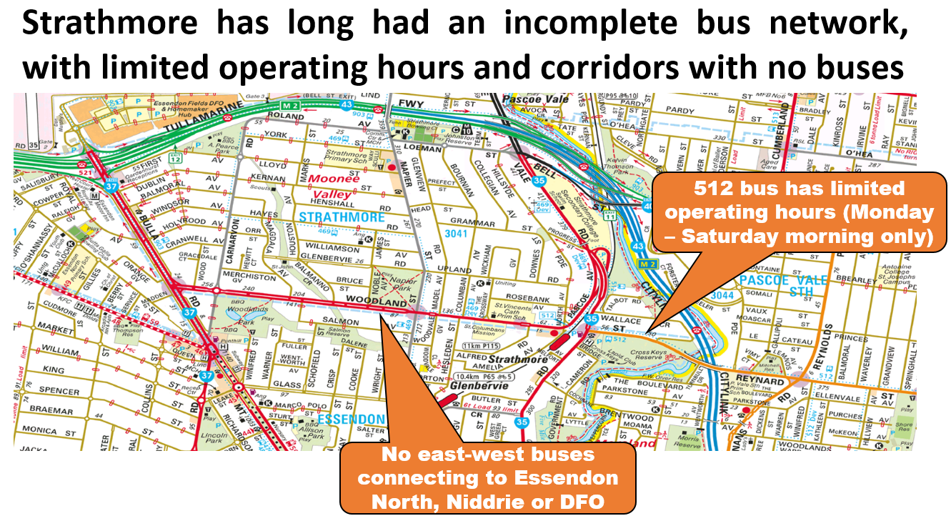
Strathmore has a train (unlike the others). On weekdays and Saturdays it has service to the east via the recently improved 512 bus albeit still with limited operating hours. However Woodland St conspicuously lacks a bus. This makes Strathmore and its shops less useful as an interchange point compared to more distant Essendon. Also there is a large break in the grid with no bus to Niddrie, DFO or at least Essendon North shops. A recent change renumbered 501 to 469 but otherwise did not revamp the area's local bus network.
Croydon South has the half-hourly north-south 664 bus. It has an even bigger missing connection than Strathmore with no east-west bus which could have fed trains at East Ringwood and continued to the major centre of Ringwood. The absence of an Eastfield Rd bus also makes the centre itself inaccessible by public transport from much of its catchment. The 664, being a main road bus, could potentially operate at a 20 minute frequency like Sunshine West's 420 or Strathmore's 512. However bus frequency reform in the area is stymied by the half-hourly trains east of Ringwood.
Overall these areas have what you might call a basic to medium level of public transport access. None are the types of precincts that you'd want to encourage high density and car-free living without a commensurate improvement in transit service. This is unlike some of the rail-based centres mentioned above that it would have better prospects, especially with some bus network reform.
20 minute neighbourhood initiatives
What sort of improvements are included in the pilot projects?
They are basically small scale walking and cycling improvements and local beautification. Some of them are what they term 'temporary activations' introduced to assist COVID-19 recovery. Examples include local traffic calming, parklets, plantings, building beautifications and walking improvements.
20 minute neighbourhood initiatives are essentially minor capital works. I don't dispute their value. Indeed many should be routine work at neighbourhood centres across Melbourne.
But are they the sort of stuff that can be relied on to produce the big changes that metropolitan-wide plans talk about? Especially when much larger forces is pulling things the other way? I hardly think so.
As much as I think that those behind '20 minute neighbourhoods' are well meaning, and individual parts are good, I cannot bring myself to take the pilot projects seriously. Even if, like Croydon's, they got a planning design award.
When considered against the bigger picture and the forces at play they are merely three sneezes in a windstorm. We all feel better after a sneeze but let us not kid ourselves it will cure our ails.
On the other hand if the 20 minute neighbourhood program comprised building local facilities like new libraries, transit network and service upgrades (as per Stanley and Hansen and the Useful Network here), additional station entrances, accessible stops, large scale roundabout removals and new cycle paths then I'd take notice. Especially if accompanied by supportive metropolitan-wide policies like the abolition of minimum parking requirements, rewritten intersection design rules, road space reallocation, walking friendly traffic light cycle reprogramming, lower speed limits, tax law, road charging, revised personal ID rules that prohibit reliance on driving licences, and a rethink in how we plan and approve retail, education and transport projects.
That's obviously a bigger agenda. But it's needed if Plan Melbourne and its 20 minute neighbourhoods are ever to earn the credibility that it needs to succeed.
The first thing is we need to set our expectations. These changes are not full timetable reviews. If the old timetable finishes early at night and doesn't run Sundays then these changes won't fix it. If bus frequencies didn't harmonise with trains because they ran at different frequencies to them then in only one or two cases is that fixed. In all but a few instances these are minor tweaks as there have been next to no service hours resources added. It is because of this that where trains have been made more frequent the buses were not, such as discussed before in Ballarat and Werribee.
Thus, whereas the train timetable was, if anything, undersold by PTV, the bus recoordination has been oversold by them. That's been for the first two tranches anyway. Having said that they have been able to sneak in one or two bus route simplifications (such as to 512) along the way with knock-on benefits to the timetable. There's many more like this they could do but the recent record shows that cost-effective bus service reform has been a low priority for the Department of Transport.
So that's the scene. Don't expect too much but be mindful that they can slip in one or two goodies that represent progress. This tends to indicate that the problem is not so much that the Department of Transport can't do good things in service reform, but it's that they are too seldom allowed to by their hierarchy and that internal systems don't provide capacity for it to happen at nearly the pace it should.
Next month's changes are mostly in the south-eastern suburbs and the Mornington Peninsula. Most are operated by Ventura or CDC. There are also some around Epping and Bundoora, operated by Dysons.
I haven't scanned all 90-odd timetables but here's some comments on a few noteworthy ones that change:
556
Changes here are minor. 556 is a popular route that retains its unharmonised 22-24 minute frequency. Also keeps its complexity and extreme indirectness on northern part. Background here.
577
Two buses per hour but to harmonise with trains it keeps its rough irregular 40 / 20 minute pattern weekday interpeak. This is quite common in the Epping area with routes 564 and 569 retaining similar patterns.
624
Not mentioned in PTV's list of routes getting new timetables. But it is getting a straightening through a residential part of Chadstone.
First made public by local MP Will Fowles, it simplifies the route with five fewer turns. Compare before and after below.
The 624 is one of Melbourne's most complex and convoluted bus routes. It's an amalgamation of several simpler routes. Its current complexity is a relic from the 1980s-2002 era when it was fashionable to save on buses by amalgamating routes (and often make them illegible to preserve coverage). April's change is the easiest (though least important) simplification that could be done to it.
732
732 could be considered two routes, as follows: 1. a long Box Hill - Upper Ferntree Gully route running to minimum standards with an ordinary weekend frequency. 2. Short trips from Vermont South to Knox City intended to meet every tram (the called-at-the-time "Knox Transit Link") to replace a politically promised extension with high frequency and long operating hours. This segment of the 732 is one of just fifteen truly full-time bus routes in Melbourne.
The Knox Transit Link has not been a very good patronage performer. If you wanted to run wide span routes to the Knox area this might be better done with other routes that connect to nearer train stations or larger activity hubs. Anyway it's getting cuts with the last hour's service being removed.
732 will remain with longer hours and higher frequency than any other bus route in the area but it will no longer meet all trams late at night. Though to be fair this precedent of not meeting trams at all hours was first set when the 75 became one of the six routes that got 24 hour Night Network service in 2016 but the connecting 732 missed out.
This is like a 'death of a thousand cuts' approach to bus reform. If a route is poorly used you let it fade away over several timetable changes, with resources going to routes that justify upgrades. This is the Perth approach discussed here. You eventually get your network vision but it may take longer than a wholesale change. It compares with the 'big bang' whole network reform approach like that which failed in Adelaide. They may not get any reform for a while given the political backlash when tried. So it might actually end up slower and less sure than the Perth approach. However for the Perth method to be credible here the capacity of the Department of Transport to implement minor bus route and timetable changes needs to be about five to ten times greater than it currently is.
733
Can't see much change here. If you were going to cut services on the 732 (as done above), the route you'd logically add trips to is the busy 733 at least between Box Hill and Clayton as a first step to it becoming an SRL SmartBus. It's the same bus company too, which makes it administratively easier (not that this should be a significant consideration when determining service priorities). This appears not to have been done.
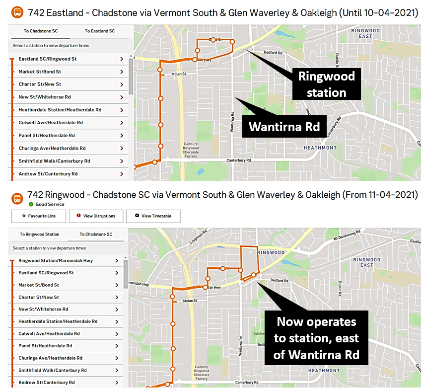
742
742 has stopped short of Ringwood Station for decades. Anyway the April 11 timetable finally extends it to Ringwood Station which is good news. This complex bus route, again pieced together from others, has a lot of history, many variations and several quirks. For instance when the old 3 zone fare system operated it allowed a trip from Zone 1 to Zone 3 with a single, cheap, Zone 2 only ticket.
Like the 624 mentioned later, the 742 has many other issues that make catching it a complex exercise. The 11 April changes don't address them. A special essay devoted entirely to it would be needed to describe its route and timetable quirks. That is exactly what I do with an item describing it in more detail appearing on a future Tuesday.
788
Here's a very good coordination improvement that largely fixes a problem I've raised severaltimes. For a long time if you wanted to spend a whole Sunday on the Mornington Peninsula you had to get a super-early train to Frankston and wait for nearly an hour. This is because buses were planned to connect with trains in the inbound direction but not outbound. The 31 January train timetable improved things a little but there was still a 46 minute wait at Frankston (train arrived 8:23am, first 788 left 9:09am). And if you were on the next train (arrive 9:24am) then your wait to the 788 would be similar with it leaving at 10:09am.
The new 788 timetable resolves this issue by spreading trips out to improve span. Hence the first Sunday 788 departs Frankston at 8:33am. That cuts interchange time to a more reasonable 10 minutes. Hence the new timetable makes visiting the Peninsula on a Sunday much more practical.
The 10:09am bus remains as before. That provides a connection off the 10:04am train arrival. Personally I regard that as too tight. The Frankston line is not that reliable and the slightest train delay will cause the bus to be missed. That's a big consequence for an infrequent and long distance bus. Even though DoT bus route specifications often call for 5 to 10 minute connection standards my inclination is to prefer 10 minutes for longer distance or less frequent bus or coach routes. Still this problem is not as big an issue as it was pre-January 31 as cautious passengers have the option of catching the train that arrives Frankston at 9:44am thanks to that line's 20 minute maximum wait.
Frankston's other key long distance bus routes are the 781 and 782. These have kept their first outbound trip as being just after 9am. That's a poor fit for either the 8:23 or 9:24 am train arrivals. Ideally a future train timetable change would shift the 9:24am train arrival to approximately 9:03am to provide a more even spacing between the 8:23 and 9:44am train arrivals.
888 & 889
Not part of the April timetable changes these are two new routes that will be starting later this month. More here. My write up here.
900
The Caulfield - Rowville SmartBus serving Chadstone Shopping Centre. It has very high usage despite its half-hourly weekend frequency. Thus it would be a top priority for a frequency upgrade, particularly on weekends. Did it get one in this new timetable? Sort of.
Instead of the 30 minute Saturday frequency the new timetable boosts frequency to every 20 minutes between approximately 2pm and 5pm in both directions. This coincides with peak shopping times at Chadstone. There may have been an attempt to do something inbound, with intervals between some morning trips arriving Caulfield varying between 20 and 36 minutes. It's an improvement but a very parsimonious one achieved by cutting weeknight inbound frequency between 6:10 and 7:10pm. And with intervals sometimes exceeding 30 minutes it arguably does not meet SmartBus minimum service standards at certain times.
Stage 3 of the recoordination is a similar pattern to before. Mostly minor changes but some that are worthwhile. Most notably the 788 and 900 along with the minor straightening of part of the 624. If you spot any other changes of note please leave them in the comments below.
Included in this group, but not covered here so far, are dedicated university bus services. There are several operating in Melbourne and Geelong. They may run to a fixed route or timetable or be 'on demand' services.
University buses sometimes cover areas or corridors where regular public transport doesn't exist or is lacking, eg for travel between suburban campuses. In other instances they parallel regular transit routes. Greater directness, higher speed, a one-seat ride, a fare-free trip or better security might be reasons for the dedicated route running alongside public services.
Today I'll run through the known university services and discuss them relative to parallel public route services.
This has been running for years between the Caulfield and Clayton campuses. It's pretty much the gold standard for a campus shuttle with service every 20 minutes between 7am and 10pm on university days. Claimed travel time is 15 to 30 minutes.
The Caulfield campus is physically very near Caulfield station. Walking access though is longer than it should be due to the lack of an eastern entrance at the station. 20 years ago regular public transport to Clayton consisted of boarding a Dandenong train (then every 15 minutes) and changing to a Route 630 bus at Huntingdale (every 20 minutes) that may or may not connect due to the unharmonised headways. No wonder why
Since then there have been several substantial improvements to the regular network. 2006 saw the new Route 900 SmartBus from Caulfield to Rowville via Monash University Clayton. This provided a one-seat ride between the campuses every 15 minutes. But it was slow due to diversions at Chadstone and Oakleigh. Travel time could be cut by taking the train from Caulfield and getting the 900 at Huntingdale. But for many years this used a different stop to the 630 so it was hard to know where to wait for the next bus to Monash.
The Huntingdale connection problem improved when the 601 express shuttle started. This provided a true turn-up-and-go service connecting Monash Clayton with its most accessible train station.
There were further improvements. Route 900 was upgraded from every 15 to every 10 minuted during peak periods. Dandenong line trains had a similar frequency upgrade interpeak, improving connectivity at Huntingdale. Another improvement was a bus interchange nearer Huntingdale station to replace the previous inconvenient stop. That's been good for 601 passengers but has slowed through travel on the 900 by introducing an extra loop.
Caulfield - Clayton campus travel by regular public transport still takes around 45 minutes (on days the 601 is running). This compares to the 15 to 30 minutes claimed by the intercampus shuttle. This remains at if not above previous service levels notwithstanding the abovementioned upgrades to regular services. This is not without trade-offs, which I'll discuss later.
What about the future? I can't help raising the Caulfield - Monash/Rowville tram. It has been an iron-clad rule that every recent state government in Victoria makes and then breaks a promise relating to public transport for Rowville. State Labor promised it in 2018 but has gone suspiciously silent since despite probing from Rod Barton MP. And it's considered enough of a dead duck for Infrastructure Victoria, in its draft 30 year infrastructure strategy, to recommend against its construction. IV aren't always listened to but it is quite possible they will be in this case.
We're spending billions building the Mordialloc Freeway that would facilitate this trip but existing direct public transport for this cross-country trip is and is likely to remain non-existent at least until the Suburban Rail Loop commences service. Unlike Eastlink, which had a few token public transport projects (so they could call it an integrated transport project) the Mordialloc Freeway project is all about encouraging driving with nothing for public transport (though it could have).
An existing intercampus voyage by regular public transport would involve travel on three or four vehicles and take the better part of two hours. Hence it's no surprise that there's an express intercampus shuttle. Travel time is stated as being a far more attractive 30 to 50 minutes. Service runs from 7am to 7pm with easy to remember hourly departures. While a lower frequency than regular transport options, the big travel time savings make it worth waiting for, even if you've just missed one.
Monash University: Frankston Station - Peninsula (Frankston) - shuttle
This is to fix one of those 'last mile' problems. The Frankston Peninsula campus is actually right near a train but it's the diesel Stony Point line with an inconvenient and irregular 90 - 120 minute service. Local buses are only a little better with complex routes that haven't been properly rethought for decades.
To fill the gap Monash runs its own bus to Frankston Station. Service is every 30 minutes between 8am and 6pm.
Travel time is given as 5 to 15 minutes. Assuming that one bus is used and travel times are mostly 10 minutes or less the amount of dead running by regular bus route standards is quite high. Also the 30 minute headway means it's not a turn-up-and-go service which one might expect for a short trip to a train every 10 minutes.
Footscray is seen as a suburb of sketchy dark crime-ridden streets along which students walk and wait for public transport at their peril. Accounts from students back this up. One response by universities has been to run campus buses as 'security shuttles' to the nearest station. Unlike with regular public transport, shuttle users have the assurance of an on-board security guard (including apparently during the day).
Like the Monash Frankston Peninsula campus, the VU Footscray Park campus has a 'last mile' issue, though nearby public transport is more frequent than at Frankston. Nevertheless the regular routes that are nearest the campus still have shorter hours than those further away (eg the 82 trams and trains at Footscray). I discussed ways to run premium quality high frequency routes nearer the VU campus here (for 406) and here (for 220).
We don't yet have that but there is the shuttle. This runs from 6:30am to 10:30pm. There isn't a timetable so we don't know its frequency or arrival times (which could be an issue for those wishing to optimise connections to trains at Footscray). However there is a live tracker which can be viewed here. This may help users time their walk to minimise waiting at the VU end.
This is another 'last mile' problem though the 500 - 600m distance to St Albans station would mean that it's quicker to walk, especially in the 'from station' direction.
423, the regular route bus passes near but not into the campus. It runs every 40 minutes and its geometry isn't particularly helpful for fast campus access due to the need to serve Furlong Rd and Ginifer Station.
Hence the shuttle. Unlike other campus' routes, it runs to the campus in the morning and from the campus in the afternoon and night. Morning trips depart St Albans station every 30 minutes between about 7:30 and 11:30am. This does not harmonise with off-peak trains (every 20 min). Travel time is 10 minutes for the first campus stop and 20 minutes for the last stop (named fitness centre). I'm guessing that just about everyone who can walk would walk given the relatively short distance to the campus and a fairly high chance of beating the bus.
A more intensive service runs from the campus in the afternoon. Starting at 5pm, services run every 15 minutes until 10:45pm. This frequency is at least twice as good as any regular evening public transport in the area including the train (every 30 minutes). Travel time is also less, being 10 rather than 20 minutes.
The website here is confusing. The intent of the service appears to be to link two campuses and at least one car park. The map shows three routes: green, blue and a lighter blue. Bus positions are shown. Intervals between buses appears to be 25, 30 or 35 minutes.
Effect on the regular public transport network
It varies. It can be both good and bad.
Regular public transport works best when it groups diverse passenger types and purposes in the one well used vehicle. The trade-off is that people may have to walk to it but in return they get something that runs frequently all day and preferably runs in its own lanes for faster travel time. University students are some of the best customers of the regular public transport network. Their car ownership rates are lower than average and they travel day and night, boosting all-important off-peak, night and weekend usage.
The risk with university shuttles is they could undermine patronage on the regular route where they largely duplicate it. And they may weaken the business case for frequency and speed upgrades. This is most notable for the Monash Caulfield - Clayton bus versus the parallel 900 (or a train + bus combination involving the 601).
The same is arguably so for the Geelong - Deakin service where Route 1 is largely overlapped. If you didn't have the campus shuttle then one might be able to make a case for the regular bus to be a more turn-up-and-go 15 or even 10 minute frequency.
There is a risk that the existence of a university shuttle could justify inaction on fixing the regular network. Frankston is an example. Its local bus network has sat unreviewed for decades. Inner Frankston is too big for walking and it needs its own turn-up-and-go network including connections to the university, hospitals, station and CBD. Such a network could be formed from improved and simplified services from outlying areas. However reform here has been almost non-existent with the basic route structure similar to what it was 50 years ago, except, if anything, more confusing.
Sometimes universities, fed up with state government inaction on transport services, can play a constructive role through starting their own services. As an example in 2014 Deakin University (this time in Burwood) ran a bus to Surrey Hills station called the Cube. In theory it ran every 20 minutes, not matching trains every 15 minutes. But in practice it seemed to run more frequently. At the time there were a hodge-podge of buses between Deakin and the Ringwood line (281, 767, 768) none running better than every 30 minutes interpeak. That mess still remains but the momentum of the Cube led to a new Deakin - Box Hill express shuttle called the 201 as an official PTV route. The concept was good but it was a half-hearted attempt, with an inferior 20 minute frequency and wasteful duplication with the parallel 768 (that should have been scrapped and incorporated into the new route).
Then there's the VU Footscray and St Albans situation where crime and personal safety appears to be a key reason for bespoke services. This is disturbing. The regular network (and access to it) should be safe and seen as such. If it isn't then it will lose patronage, and not just VU students.
To summarise, public transport has agglomeration economies where it is best to try to corral as many trip and passenger types onto the network to provide the best frequency of service. Passengers may have to compromise compared to if they had bespoke services, but overall mode share tends to be higher with a catch-all network. An example is Melbourne University or RMIT which don't need bespoke services like other campuses have since its access is so good via regular routes that operate at frequent intervals over long hours. And their modal share for public transport is higher than other campuses.
If a university has to run its own buses then that may say something not complimentary about regular public transport. Given that students are normally more willing to use it than most other groups in society, that should ring alarm bells as it means that other groups will be even less inclined to use it.