Friday, July 30, 2021

UN 99: Remembering Chelsea station and its bus interchange

As far as train - bus interchange stations go, the now demolished Chelsea was perhaps half good. Which makes it better than average by Melbourne standards which are not particularly high (a representative example of the latter featuring trams is Caulfield that I discussed last week). 

Chelsea wasn't always thus. At one time its main bus stop was north of Chelsea Rd. This required  waiting at and crossing a minimum of three roads. I described this convoluted arrangement here in 2008 (videos no longer available). Luckily it got fixed soon after.

That upgrade (which predated the 902 SmartBus) moved the bus stop to where it should always have been - that is the south side of Chelsea Rd. That cut the number of road crossings required for people changing from ex-city train to bus from 3 to 0. And dramatically reduced the walking distance. 

You can see all this on the map below.  


Transfer arrangements are different for other trips, such as Frankston to Springvale involving the 902 bus. There passengers would alight from Platform 1. The most direct way to the bus stop is to cross the tracks on Chelsea Rd. The alternative, via the underpass past the bottom of the map is less direct. 

Those arriving at Chelsea on the 902 (or who wish to catch the 857 to Dandenong) needed to cross Station St. There was no zebra crossing near this bus stop even though it was a popular desire line, towards the underpass which provided the best means to reach the shops and Platform 1. 

However traffic volumes were generally low enough to be able to cross with minimal waiting so compared with many other places a zebra crossing would have been low priority. This was because Station St was generally a local access road since it lacked a direct connection over the Patterson River to Carrum. That was until the Karrum Karrum Bridge was built (as part of a project associated with the Carrum grade separation). Having that bridge for cars was a mistake as it made Station St more attractive to through traffic and thus made it a more popular rat-run. Amongst other things this improved driving access to shops at Patterson Lakes at the expense of walking access to shops at Chelsea. 

Also the 'official line' would be that the signalised Chelsea Rd is close by and people should cross at the lights instead of taking the shortest way across Station St to where they want to go. Either this is directly opposite the underpass  (for access to Platform 1 citybound or the shops) or near the Platform 2 entrance. The difficulty here is that this requires people walking to Platform 1 to cross the tracks rather than use the underpass, the former of which carries its own risks (and a reason for the level crossing being removed). 

New stations

This is now of course history. Different train / bus transfer arrangements will apply when the new Edithvale, Chelsea and Bonbeach stations open later this year. 

Of these Edithvale draws the shortest straw. Its connection between the train and the 902 SmartBus on Edithvale Rd was never great with too much waiting at slow to change lights to make the change. But moving it north (despite its engineering merits) destroys what integration there existed before. The increased walk at Edithvale will require passengers to backtrack to Chelsea for a good transfer experience. That adds travel time, especially for those travelling from/to the city direction.

Walking access has pros and cons compared to the old station. The big win is of course no more being held up at boomgates and missing your train (though cars will still delay you). But Edithvale's shift north places it nearer the unpopulated golf course and further from densely populated Edithvale Rd and areas south. Even though the new station will have more entrance points along it (a good thing compared to the old station that had only one for each platform) it is still likely that its walking catchment population will be less since so many more people along and south of Edithvale Rd drop out of its 800 metre pedshed. This is important as walking is the main mode of access to Edithvale station. Edithvale's shift north also puts it too close to Aspendale station, especially given that Chelsea is being moved south, leaving uneven gaps between stations. 

The new Chelsea appears to be better off overall, although those in the north will have a longer walk due to the decision to move the station south. But the need to choose between crossing an unsignalised part of Station St but use the safer underpass or wait at a (unresponsive) signal and have to cross the tracks will be gone. This is great for safety. Also moving the bus terminus slightly south improves the 902's catchment to better serve people in units on streets like Golden Avenue. This can also be regarded as a win. However the old underpass was a very quick way across the rail corridor for local shoppers and it remains to be seen whether the station provides equal or better convenience. The new pedestrian bridge from Chelsea Rd to The Strand will be another gain. 

Bonbeach station has no feeder buses so this wasn't the consideration that it was at Chelsea and should have been at Edithvale. Moving it further south puts it further from a lot of units on Broadway etc (and again nearer a golf course). Somewhat offsetting this though is the greater number of platform access points. This is always good and should be praised when provided as not even some other new stations (eg Mentone) have got this right.

Both Bonbeach and Aspendale stations suffer greatly from having no direct east-west roads from areas like Aspendale Gardens and the northern part of Patterson Lakes even though these would have assisted bicycle and potentially bus access. This is beyond scope of the level crossing removals but improvements here should be considered for the future. Building more roads just encourages more cars and more driving and thus provides only short-term relief. It's fair to say that we get the congestion that we deserve. The only way to relieve it is to encourage walking and cycling for shorter trips by making these the best way to our local stations from local suburbs including Aspendale Gardens, Chelsea Heights and Patterson Lakes. This requires much more attention to safe and direct east-west car-free bikeways and a rethink of parking policy to prioritise local shoppers over commuters. 

Chelsea pictures

Getting back to Chelsea, memories soon fade. So I'll present a few pictures around the old station so you can help visualise the above map. There's also some relevant videos that I'll link to later. 
 
1. Station St near the Platform 2 exit looking north to Chelsea Rd. This is its only exit (the new station will be better with more exits). Changing passengers must walk down the short ramp, then turn 180 degrees to reach the 902 bus stop. 


2. Also on Station St looking north but further south. On the right is the 902's last stop (and the 857's first) outside the Telstra exchange. On the left is the underpass. The walk across Station St at this point is a popular desire line for those reaching the shops and trains on Platform 1. 


3. When you do walk via the underpass this is where you come up along Nepean Hwy. This is looking north. You'd walk in that direction to reach the Platform 1 entrance (again an only entrance when there should have been at least one other further south nearer the underpass). The traffic light you see is a pedestrian crossing. It was very popular as it (more or less) lines up with the underpass, is central to the shops, has a relatively short cycle time (could have been 45 seconds but seemed to be nearer 60 seconds latterly) and operates independently of the boom gates (which interacted with nearby signals to make walkers wait longer at certain times). 


4. The main Platform 1 entrance of Chelsea station. Includes a ramp which required some backtracking if coming off Chelsea Rd (to the north). The old ticket office was here.


5. Just around the corner from the above, with the Chelsea Rd level crossing visible. Walkers went through a narrow passage that was unsuitable for the high numbers of mobility scooters and bikes that passed there. There was also insufficient space for people queuing eg when the boom gates are down. 


6. The Station St side of the walkway, looking towards Nepean Hwy. The 902 bus leaves from the stop to the left. We are now almost where we started at in Photo 1. 


Videos 

Some videos of Chelsea station pre and during demolition. 

1. Train - bus connectivity in 2009 shortly after the bus stop was moved to the better location. 


2. Chelsea station in 2010.


3. Inside the old signal box at Chelsea station (early 2021)


4. Chelsea station a few days before demolition. 

5. Demolition of Chelsea station in late July 2021.


6. A best practice train - bus interchange. Just 10 steps from train to bus. Perth's Kelmscott station. 


Index to Building Melbourne's Useful Network items


Tuesday, July 27, 2021

Outer suburban road intersections - Toronto versus Tarneit

Maybe I should call this item 'Transfer Tuesday' since today's topic affects how easily one can change between buses or trams. 

Like the popular roundabout post the other week, I'm again going to talk about intersections. Unlike that post, where the emphasis was on walking, today's emphasis will be on transferring, particular between bus routes. 

The basis will be a comparison between Markham near Toronto and Tarneit near Melbourne. They have more similarities than differences. Both are about 30 km from the region's CBD, both are outer growth areas and both are ethnically very diverse. Both are built around a coarse road grid, both are served by their state's regional rail operator (with sometimes infrequent service) and the average bus in both runs about every 30 or 40 minutes. 

Governance though is very different. The Melbourne metropolitan area has multiple local government areas with none containing more than a few hundred thousand. None run significant public transport service, with this being a state government responsibility. Whereas Toronto has a large city council comprising about half the metropolitan (or GTA) population and several quite large surrounding councils. The nearest Australia has to this is probably Brisbane due to its large city council area. The latter is (unfortunately) of sufficiently large size that it runs bus services (instead of the state government), with network planning stuck in a time-warp and notoriously poor coordination with the state-run trains.  

In Melbourne the big divide is between trams and buses with the latter being the poor cousin, with even the premium 'SmartBus' routes sometimes wanting. But in Toronto it's more about whether you are in the TTC area or not. If you are you will probably get frequent bus service and may also have trams and the subway. Whereas in somewhere like Markham you might only have a third the bus service and the occasional GO train. Markham's Melbourne equivalent would have (probably electrified) trains every 20 or 30 minutes radiating about 40 or so kilometres out so is probably overall better served.  

Toronto's artificial boundaries also make themselves apparent with passenger information. Whereas Melbourne has reasonably consistent state-wide multimodal information provided via PTV, that part of the GTA beyond the TTC boundary is basically just a grey void on their network maps. Venture north at your own peril is I think what they're saying.  

As the late Paul Mees wrote 20 years ago the biggest differences between Toronto and Melbourne are in the services its middle suburbs receive, with service offerings in inner and outer suburbs more similar. Very roughly, and there will be exceptions, inner suburbs are slightly in Toronto's favour (due to higher frequencies and better buses) and outer areas probably lean in Melbourne's favour (due to our more extensive and less infrequent electrified rail network). 

How is a Toronto outer suburb like a Melbourne inner suburb?

Anyway (for a change) service isn't going to be today's main topic. Instead I'll focus on a certain trait that makes Toronto's Markham more like a Melbourne inner suburb than to otherwise similar Tarneit. 

The pictures below are to a similar scale. They show non-roundabout main road intersections that I consider representative for their areas. 

In Markham road junctions are often simple. Walkers need to cross once or twice to reach any point. Whereas in the Tarneit example they need to cross on more occasions and somewhat less directly due to the presence of slip lanes. In this junction the latter do have zebra crossings but these are not always observed by drivers who may still be travelling at speed as they are relieved at not having to stop at a traffic light.

The other thing you might notice is the placement of the bus stops. In three out of four cases Markham places them right at intersections. The outlier stop is about 40 metres distant. One route runs north-south while another runs east west. If you wanted to you could make any change without much walking (though waiting is another matter due to infrequent service). 

Another nice touch (possible at this intersection but likely not at others) is that the bus route numbers match the numbered street names. This makes catching a bus and knowing where they go easy, even for people who rarely use them.  

What about that Tarneit intersection? The picture before had no bus stops. Does that mean there are no buses in the area? Actually no; again there are two routes. 150 runs east-west while 160 runs north-south. Service levels are roughly similar to what Markham gets, give or take.

Below is a zoomed out map. Unlike in Markham less effort is made to put bus stops at intersections.  Instead they are typically 100 or more metres back. Therefore if you did want to change between buses you're walking maybe 200 or 300 metres rather than 30 to 50 metres. This is a large difference in passenger amenity, especially during inclement weather. 

Does Melbourne do the stops at intersections thing anywhere? Yes. The examples below compare an inner suburb of Melbourne (Brunswick) with an inner suburb of Toronto (Caledonia). Melbourne has trams while this part of Toronto has buses. But both have stops near intersections with Melbourne doing slightly better here (note that unlike the maps before the Melbourne map is more zoomed in with Toronto's showing a bigger area). 


Close stop placement, especially if accompanied by frequent service, makes public transport so much more useful as trips involving one, two or even three changes become more practical. 

Toronto does this well in both inner and outer suburbs. Even including suburbs where buses are infrequent and car use is high. 

Whereas Melbourne is not so good. In our middle and outer suburbs we build intersections that work for cars but ignore the needs of buses, their passengers or those walking for local trips. We do this by favouring roundabouts or building signalised intersections with slip lanes where they shouldn't be. Hence Melbourne gives suburban passengers a second-class experience with stops in less convenient locations compared to similar suburbs in Toronto. 

What are some other things I noticed? Side-views of the abovementioned intersections are below. Markham's has a narrow island that is unlikely to be wide enough for people to wait. Whereas this appears to be the intention for the wider one in Tarneit which also has a 'beg' button. 


I am in two minds on this. The slower walkers would prefer our arrangement with a better central refuge. But you don't want a case where because Vicroads engineers see a refuge they make walk times so short that they want pedestrians to cross in two turns. I really can't comment further on the walkability of these intersections without knowing (i) the worst case waiting time and (ii) the crossing time allowed versus the road width at both intersections. 

The next picture is a comparison of walking directness. The Markham intersection does not send walkers on detours. Whereas a roundabout, especially if the traffic engineers have been 'nice' and added a signalised pedestrian crossing, does. That's bad if you are interested in walking being a practical and useful transport mode as opposed to mere recreation. If you're pro-walking you must be anti-roundabout and seek to remove large ones with no less energy than we are doing with many road/rail level crossings.

As I said a couple of Fridays ago requiring a walker at 4 km/h to go an extra 500 metres is like making an 80km/h driver go 10km. Even smaller detours like we force by having bus stops away from intersections is not something that we should design for and accept. 

Conclusion

This has been different to the usual Tuesday offering but people appear to like reading about  road intersections, walkability and connectivity. The Markham experience has shown that even if you have otherwise car-centric suburb design and mediocre transit service you can still have road intersections that are less worse for walkers and bus users without the sky falling in. Comments are appreciated and can be left below. 

Friday, July 23, 2021

Building Melbourne's Useful Network Part 98: Making Caulfield a world-class Metro interchange

On Wednesday I was idly leafing through Vukan Vuchic's Urban Transit: Operations Planning & Economics (essential reading for any transit planner and if you buy it here you support this blog) and something jumped out at me. This track diagram on Page 220. 


You might have to look a bit to see what's good about it. The direction of the arrows might throw you out given we're left side drivers and our trains do the same. 

If it helps, assume that left is towards the CBD (via different lines) while the lines fan out to various suburbs to the right. And look at who can and cannot easily change between trains without having to leave the platform they are on. 

Follow the arrows. You can see that people coming toward the CBD from direction A can remain on the train if it suits. Or, if their inner-city destination is better served by Line B, they can alight at the station, and get an inbound B train, all without leaving the platform. This is because the platform is an island with citybound A and B trains leaving from opposite sides. 

Coming home? It's the same. Board Line B, alight at the station, remain on the platform and before long Train A will get you home. Again it's a simple cross-platform interchange involving no ramps, stairs or lifts. Provided trains are frequent changing is hardly an inconvenience at all. 

What about if you're the reverse? That is you live on Line B but your destination is best reached via Line A. Again it's an easy cross-platform change. And in both directions too. That makes this arrangement pretty much the gold standard as regards both capacity and accessibility. 

Best practice compared to us

The above is what world's best practice Metro system design looks like. As you'd expect Melburnians  who have seen it work overseas compare it favourably to what we have here. That is basically electrified country lines that vanish in a confusing and sometimes midday reversing CBD loop with often primitive interchange arrangements. 


Fortunately we're gradually untangling the City Loop. Currently we're two down and two to go with about a decade between big reforms. January 2021 was the most recent

The optimist in me says that if we get cracking we might be able to reform the Burnley Group next. That could include simpler peak stopping patterns10 minute interpeak services to Ringwood and a Frankston/ Werribee/ Williamstown style 20 minute maximum wait. All are cheapish upgrade that would benefit many marginal seats. It's a great opportunity to bring forward some benefits and a reason why the Minister should not listen to the 'do nothing until Melbourne Metro opens' camp when it comes to train services.

Then there's the northern group, ie Sunbury, Craigieburn and Upfield. That will almost certainly have to change when Metro Tunnel starts as the Sunbury line comes out of it to become the Metro Tunnel service. That frees up lots of capacity and should allow more even, reliable and frequent timetables. But even if that wasn't so, there is a strong case for better off-peak, evening and Sunday morning frequencies on busy lines like Craigieburn and Sunbury to happen as soon as possible. 

Priority Caulfield

Getting back to that diagram in Vuchic's book, one station jumped out at me as needing that track and platform layout, even if it had to be rebuilt. I posed the question on Twitter. 


Without clues or prompting the answers were all the same - Caulfield. 

And I think they're right. 

Right now Caulfield is not a good station for what the network asks it to do. This affects a metropolitan catchment of close to one million, including Metro lines to Frankston, Cranbourne and Pakenham and V/Line services to Gippsland. 

Caulfield will only become less fit for purpose if nothing is done due to the extra transferring that the Metro Tunnel operating patterns will necessitate. 


Caulfield currently consists of four platforms. Two are side platforms while two form a central island platform. Passengers changing between trains often need to pass in and out of barriers and go up and down ramps. And even for the minority of trips where a cross-platform change is possible the station building is sometimes in the way. 


Some computerised diagram flipping made the map look more sensible. Even more so with labels added. There's four platforms, just like now at Caulfield. Except they are on two islands rather than two sides and one island. 


With places attached you can see some real-world benefits, especially post Melbourne Metro when Dandenong trains will go through the Metro Tunnel while Frankston trains will resume to going via the City Loop. If you're a Frankston line passenger and want to go to St Kilda Rd, Flinders Street, Melbourne University, Footscray and eventually Melbourne Airport then a simple cross-platform change at Caulfield will enable it. Ditto for the trip home. No more going up and down escalators and stairs with luggage like with the current Southern Cross / Skybus connection.

Dandenong passengers wishing to go to South Yarra, Parliament or Southern Cross will have a similarly easy transfer. It is critical we get this right as these are popular destinations that are currently one-train but will involve a change when Metro Tunnel services start. Also, because rail systems tend to corral transferring passengers in inner stations such as Richmond (even if they don't strictly need to be there) it is good for long-term core capacity for transfers to be done further like at Caulfield. Especially if it is configured to permit step-free cross-platform changing as the above diagram does.   

Dandenong - Frankston interchanges aren't cross-platform in the above. Currently Dandenong up - Frankston down is conveniently cross-platform while Frankston up - Dandenong down is extremely inconveniently not. But the configuration above would be better overall with added walkways and freedom from fare barriers for train to train changes. 

Other considerations

Everything here has been about improved passenger access. Differences between the schematic map and what's actually at Caulfield have been glossed over. Most notable is the two instances where Frankston lines must cross both Dandenong lines. Doing this requires grade separated tracks to avoid trains crossing other paths and complex point switching (both of which would severely compromise capacity, scheduling flexibility and reliability). 

The diagram above also doesn't consider the three lines going to Frankston and the sidings in that direction. You can see them in more detail on the vicsig.net Frankston line guide

So as you can see there are complications compared to what I got out of a textbook. And the above is not the only ideas people have for Caulfield. For example the Victorian Transport Action Group has its own alternative for Caulfield which involves five platforms to create a turnback for airport rail, a holding/passing loop for freight trains and a new pedestrian concourse. 

So there are several ways to skin the Caulfield cat, each with their pros and cons. However Caulfield's strategic position on the network make an upgrade necessary like how we've rebuilt other stations like Footscray and Sunshine. While some might criticise 'taj mahal' stations elsewhere (eg did our Thomastown or Brisbane's Springfield need to be so grand?), where they handle high passenger volumes and efficiency is essential then  spending money to make them work is fine. 

Paradoxically though measures of success with transit interchanges are different to other buildings. For example successful shopping centres want people to linger longer and spend more. Whereas successful interchange stations are the opposite. They're almost unobtrusive, getting passengers in and out as quickly as possible while keeping them safe and not being rained on. 

A truly useful transit network requires deeper attention to matters like within-station interchange than has hitherto been given for both capacity and accessibility reasons. We can do things with better ramps, underpasses and overpasses but of the various possibilities cross-platform interchange between frequent services is the 'gold standard'. A side-benefit is that if we make this transfer painless then peoples' willingness to make more complex trips involving other connections, including to buses, will probably increase. My theory is that people have a fixed 'hassle budget' and if it's too hard then they'll just not make the trip or drive instead.


It is encouraging that the 2021 state budget has provided funding for track upgrades near Caulfield and improved interchange connections. Although some have expressed concern that removing points (apparently necessary for high capacity signalling) reduces operational flexibility, especially during disruptions. It is important that the scope for this project includes consideration of revised track and platform layout that could improve interchange. 


More for Caulfield?

I've covered train to train transfers. What else does Caulfield Station need? 

Intermodal connectivity. It's currently terrible to the 3/3a tram. And the 900 bus could be closer. The best interchanges have connections under the one roof with transfer distances measured in steps, not hundreds of metres. 

Melbourne needs to kick the habit of providing only single exits from station platforms as this reduces a station's pedshed. Especially in high density areas like South Yarra and what Caulfield is becoming. Each platform needs a minimum of two and preferably three exits (ends plus centre). To that I'd add numerous others like Camberwell, Frankston, Werribee and Glenhuntly. 

And we need high quality connections to Caulfield from some directions, most notably the north, north-east and perhaps the south-west. Currently, if they exist at all they are just buses every 30 to 60 minutes stuck in traffic. Useful Network Part 41 describes how we can do this economically with buses although I'm quite partial to other concepts like extending the Alamein line about 4km to Caulfield to get the speeds desirable for some of these connections.

After that there is land use. For one of the most accessible large parcels of land in Melbourne, Caulfield Racecourse is grossly underused. And there is demand for open space in nearby densifying Glenhuntly which has too little. Both are 'higher and better' uses for the racecourse site than the occasional horse race or exhibition that is currently there. Low-car development that moves the racing out, intensifies development in the part near the station and adds full time accessible public space in the Glen Huntly area appears highly desirable given the excellent access it will have (including not only Metro Tunnel but also Melbourne Airport a few years later). 

Conclusion

What are your thoughts on Caulfield? Is having flying junctions a too high price to pay for the convenience of bidirectional cross-platform interchange? Would you prefer the (likely cheaper) VTAG scheme? Should there be more emphasis on a low cost multimode component to bring both the tram (eg rerouting via Sir John Monash Drive) and buses closer? And, perhaps more importantly, are there lessons in this for Suburban Rail Loop interchange stations? Thoughts are appreciated and can be left below. 

PS: Useful Networks for other areas are here.


Tuesday, July 20, 2021

Timetable Tuesday #127: Out to Montrose on the 689

A couple of weeks ago we looked at the 690 from Croydon. Today we’ll revisit the area, but head east instead of south. The 689 is a short route, running from Croydon to Montrose.  It is a local coverage route, serving some areas to the north that the more direct and longer established 688 to Mt Dandenong Rd misses. At the end is a loop.


689’s purpose is to connect residential areas to Croydon where there is a station and long-established shopping area nearby. Its catchment is largely postwar established suburbia. It’s leafier than many outer suburbs and has larger than average block sizes and lower than average residential densities. 

The map below shows it in relation to other routes. It serves part of Hull Rd before veering off south (with another section of Hull Rd being served by the 680 to Lilydale).  The run south to rejoin the 688 (and the 689) on Mt Dandenong Rd means that Hawthory Rd gets a bus at the expense of the unserved western section of Cambridge Rd. Nearby Lincoln Rd also doesn't have a bus but both it and Cambridge are in areas served by the flexible route Telebus. Another issue is that 689 goes near but not quite too Mooroolbark Station. This extends the time that Montrose people need to allow to reach the train network as Croydon is further away. 

After briefly meeting Mt Dandenong Rd, the 689 then veers east via Durham Rd to the eastern part of Cambridge Rd, albeit with its extremity in a single directional loop via Montrose Rd. This means that not all parts of the route can get to the Montrose shops, although all parts can get to Croydon.   Montrose shops isn't exactly a dead end but also isn't exactly a strong terminus for a bus.  


Timetable

As is widespread in Melbourne’s outer east, the 689 is a limited service route that lacks the 7 day service added to many Melbourne bus routes after 2006. On weekdays it runs roughly from 7am to 7pm. Off-peak service is roughly hourly, with spacings nearer to 40-50 minutes in the morning peak. Afternoon intervals vary between about 40 and 90 minutes with the latter around the pm school peak. 

The first weekday trip arrives at Croydon at 6:57am, meaning that the 689 does not work for those with an early start. Eleven hours and fifty eight minutes later the last trip leaves Croydon, at just before 7pm.  

Saturday service is hourly in the middle of the day with 80 to 90 minute gaps between first and second trips. It is very much a shopper type service with service between 9 and 5pm. These hours are too limited for those who might otherwise use it to get to work, especially if they need to change to a train to go to Ringwood. This timetable also runs on most public holidays, as per the standard. No Sunday service is provided. 

History

The area’s longest established bus routes are what we know as the 688 and the 690. 689 is a bit newer but can still trace its past to the 1960s. For much of its history it followed the 688 along Mt Dandenong Rd. However some time ago it got rerouted to give Hull Rd a service (which once had earlier iterations of routes 673 and 680 - since removed). 

Patronage

On school days the 689’s patronage is only slightly below average for a Melbourne bus route at 20 passenger boardings per hour. This drops to 15 on school holidays, indicating significant school student usage. A high dependence on school students travelling to school is a common pattern in the outer east where car ownership is high, bus operating hours are short and services are too infrequent to be serious feeder options for commuters. Saturday usage is at an even lower than average 9 passengers per bus operating hours. 

Conclusion

The 689 is a local coverage route. It, and surrounding routes, have had no reform for a long time. Bus network reviews were done about 15 years ago but implementation was very limited, especially in the Mooroolbark area. Many nearby areas either have no buses (eg Eastfield rd Ringwood east), are served by occasional deviations of main routes like the 737, or get limited hours variable route Telebuses. Where they have their own routes they like the 6-day 689 or the 5-day 680, may be only part-time.  

What do you think should happen to the 689? Is 7 day service important or should network reform happen first? Should it run by Mooroolbark Station to improve rail connectivity? Any reform to the 689 is likely to interact with reform to other routes including the 680, 675 and various Telebuses. Comments are appreciated and can be left below. 

More Timetable Tuesday items here

Friday, July 16, 2021

30 evil big roundabouts that need to go

Big two or more lane roundabouts are a road engineer's fetish that have no business being near where people walk. Unlike lights with a walk phase they offer no certainty for the walker who needs to cross. Also they encourage drivers to look right for cars and not left for people walking or cycling so may pose a safety risk (even though some smaller roundabouts beyond scope of this item have zebra crossings on their approaches). 

Large roundabouts also encourage continuous, fast-moving traffic without gaps. This is bad for people crossing both at intersections and midblock. At best there may be 'beg button' pedestrian signals on one or more of those legs but they are often away from walking desire lines. And they don't fully help if you need to cross multiple entry points, not all of which are signalised.   

Vicroads, which is extremely good at building roads and moving cars, tells walkers they are neither catered for nor welcome at many of its roundabouts. Their pedestrian safety page includes a section on crossing the road. There is a dedicated 'fact sheet' on crossing at roundabouts. That's gloomy news for walkers, including mention that they have no rights at roundabouts. 

A separate section deals with multi-lane roundabouts, with mention that it can be hard to cross due to fast and continuous traffic. Often so called 'safer places' to cross simply don't exist for hundreds of metres or more. 


At roundabouts all onus is put on the walker to be safe rather than the controllers of two (or more) tonne vehicles that kill about 40 Victorians walking each year. According to the fact sheet, pedestrians may not know the rules and can make mistakes. However there is no mention of car drivers making mistakes, probably because roundabout rules are so stacked in their favour that they can do no wrong (unlike the walker who needs to time their dart across carefully after an indefinite wait). 

Vicroads' take home message to walkers at roundabouts? Go away. Take a different route. Drive, don't walk. Adding to traffic might even strengthen our business case for more or wider roads (that discourage walking even more). If you don't drive then just stay home as we don't think your trip is important. 

The human scale, which a lot of traffic engineers don't get, is critical. Asking a walker at 4 km/h to deviate 500 metres is like asking a car driver at 80km/h to deviate 10 kilometres. Vicroads would never dream of asking that of drivers, especially for local trips. And if they did few would comply. But walking trips are somehow unimportant and expendable in Vicroads' 'move more cars' ideology that is  spoken so loudly through its infrastructure that it drowns out later messages about sustainability and active transport. 

There do exist good or at least tolerable roundabouts. Very small single lane types can work for traffic calming in local streets. Provided that their design keeps walkers on straight lines they are OK. We might be able to learn from the Dutch. Here's a type of roundabout in South Melbourne that's won praise. But examples like the latter are rare. When it comes to multi-lane roundabouts on busy roads it's easier to 'just say no' and advocate intersection signalisation (with short cycle times for efficient pedestrian access and no slip lanes for enhanced safety).  


Drawing inspiration from level crossing removals

The Andrews government has had its political ups and downs. But one thing that has held up its political stocks is the railway level crossing removal program. A large number of removals meant that most people were near or at least occasionally travelled through at least one (and often several) of the included projects. 

Although motorists are the program's main beneficiaries there were also gains for bus users, cyclists and pedestrians at some sites. Along with train passengers where stations got rebuilt. And while derided at the time the Dandenong line 'Skyrail' freed up significant local open space in densely populated areas that needed it. 

Roundabout removals are projects of similar ilk. Replacing them with signalised intersections (preferably with short light cycles and no slip lanes) can also deliver wide benefits for several types of road user and not just people walking (although that's been my emphasis today). Hence it should be possible to build large local coalitions in favour of removing the most notorious of them across diverse road user groups that would not necessarily agree on other things. 

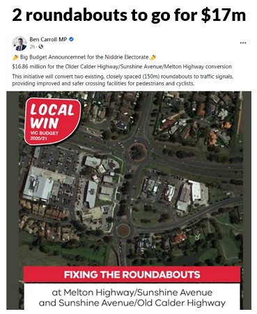
There is also government and political support for roundabout removals including budget funding. Below for instance is the Transport minister (and local member) tweet about the 2020 state budget's funding of two roundabout removals in Niddrie. 


One issue is that these, like a lot of bus reforms and how level crossing removals used to be done, are bespoke 'cottage industry' projects done one at a time. Whereas there are so many large multi-lane roundabouts that need removing that a mass removal approach could be better. Like what has been done with the level crossing removals, possibly even with a dedicated agency and a bold performance goal. 

One or two billion dollars spread over the next several years could fund a substantial program that would remove many of the worst. In the context of some recently announced transport infrastructure projects that is an affordable cost with widespread benefits across multiple seats.   

30 roundabouts that could be considered for removal

Which roundabouts need to go? To decide I jumped onto Google Maps to look across Melbourne, starting in the western suburbs (City of Wyndham). Detailed site visits have not be done, and some might be in the process of removal or even have been done (as things can move quickly in growth areas, making online maps out of date). So don't take this list too seriously. There is no ordering by priority although I comment briefly on each. Links are provided so you can explore the surrounding area for yourself. 

1. Wyndham Vale. Ballan Rd. Growth area, across from shopping centre. Likely significant pedestrian activity. 

https://www.google.com.au/maps/@-37.8757287,144.6156341,3a,75y,353.7h,83.02t/data=!3m7!1e1!3m5!1soXheDl1sIh-Q4gc9SB6hlw!2e0!6s%2F%2Fgeo1.ggpht.com%2Fcbk%3Fpanoid%3DoXheDl1sIh-Q4gc9SB6hlw%26output%3Dthumbnail%26cb_client%3Dsearch.revgeo_and_fetch.gps%26thumb%3D2%26w%3D96%26h%3D64%26yaw%3D189.47723%26pitch%3D0%26thumbfov%3D100!7i16384!8i8192

2. Wyndham Vale. Ballan Rd. Near above. Residential area with major bus routes. 

https://www.google.com.au/maps/@-37.8767457,144.6168799,3a,75y,218.34h,83.54t/data=!3m7!1e1!3m5!1soji2jXHr5Mtk34CUSiuVpw!2e0!6s%2F%2Fgeo1.ggpht.com%2Fcbk%3Fpanoid%3Doji2jXHr5Mtk34CUSiuVpw%26output%3Dthumbnail%26cb_client%3Dsearch.revgeo_and_fetch.gps%26thumb%3D2%26w%3D96%26h%3D64%26yaw%3D139.45259%26pitch%3D0%26thumbfov%3D100!7i16384!8i8192

3. Wyndham Vale. Ballan Rd/Macquarie Dr. Residential area with major bus routes. 

https://www.google.com.au/maps/@-37.8836931,144.6236298,3a,75y,278.16h,90t/data=!3m7!1e1!3m5!1sbxOKTVqc1AtFp9RPRog6kQ!2e0!6s%2F%2Fgeo1.ggpht.com%2Fcbk%3Fpanoid%3DbxOKTVqc1AtFp9RPRog6kQ%26output%3Dthumbnail%26cb_client%3Dsearch.revgeo_and_fetch.gps%26thumb%3D2%26w%3D96%26h%3D64%26yaw%3D278.16495%26pitch%3D0%26thumbfov%3D100!7i16384!8i8192

4. Wyndham Vale. Ballan Rd/Greens Rd. Major intersection. Severs residential area with major bus route. 

https://www.google.com.au/maps/@-37.8917029,144.6292771,3a,75y,339.18h,90.86t/data=!3m7!1e1!3m5!1srRA0FnzPFDlGPzfJHZCCUw!2e0!6s%2F%2Fgeo1.ggpht.com%2Fcbk%3Fpanoid%3DrRA0FnzPFDlGPzfJHZCCUw%26output%3Dthumbnail%26cb_client%3Dsearch.revgeo_and_fetch.gps%26thumb%3D2%26w%3D96%26h%3D64%26yaw%3D297.28418%26pitch%3D0%26thumbfov%3D100!7i16384!8i8192

5. Wyndham Vale. Ballan Rd/Bulban Rd. Residential area with many bus routes. Walkable to Werribee CBD. Cross and flowers indicate fatality. 

https://www.google.com.au/maps/@-37.9029405,144.6513775,3a,42.3y,258.02h,92.74t/data=!3m6!1e1!3m4!1s46_lbO-6c2A-lA4-ua4KNw!2e0!7i16384!8i8192

6. Wyndham Vale. McGraths Rd/Heaths Rd. Residential area. Near major park and playground. Buses pass.  

https://www.google.com.au/maps/@-37.8867628,144.6321777,3a,75y,294.03h,101.44t/data=!3m6!1e1!3m4!1shBePK_ymbgIzbNA5GB27Cw!2e0!7i16384!8i8192

7. Werribee. Heaths Rd/Rowes Rd. Also near abovementioned park. Residents need to cross to access park. 

https://www.google.com.au/maps/@-37.8870254,144.6357201,3a,75y,288.74h,93.38t/data=!3m6!1e1!3m4!1sJAXF7ntD0dTyJXDYs_5kZw!2e0!7i16384!8i8192

8. Werribee. Heaths Rd/Greaves Rd. Near major park and dog exercise area. Residents need to cross to access park. Buses also serve area.  

https://www.google.com.au/maps/@-37.8875511,144.6400642,3a,75y,50.56h,88.33t/data=!3m7!1e1!3m5!1ssTBs4d-suwOGUMcsJH09Ww!2e0!6s%2F%2Fgeo2.ggpht.com%2Fcbk%3Fpanoid%3DsTBs4d-suwOGUMcsJH09Ww%26output%3Dthumbnail%26cb_client%3Dsearch.revgeo_and_fetch.gps%26thumb%3D2%26w%3D96%26h%3D64%26yaw%3D214.82845%26pitch%3D0%26thumbfov%3D100!7i16384!8i8192

9. Werribee. Heaths Rd/Shaws Rd. Most residents must cross to go to church. Also buses in area. 

https://www.google.com.au/maps/@-37.8876643,144.6443,3a,75y,322.38h,95.92t/data=!3m7!1e1!3m5!1sdOWimmFXoxSEA6gxn7oX7Q!2e0!6s%2F%2Fgeo1.ggpht.com%2Fcbk%3Fpanoid%3DdOWimmFXoxSEA6gxn7oX7Q%26output%3Dthumbnail%26cb_client%3Dsearch.revgeo_and_fetch.gps%26thumb%3D2%26w%3D96%26h%3D64%26yaw%3D162.14534%26pitch%3D0%26thumbfov%3D100!7i16384!8i8192

10. Shaws Rd/Tarneit Rd. While smaller than some other roundabouts, it's very active. On one side is a busy Werribee Village shopping centre. The area contains significant housing for low income earners and car ownership is below average. Major bus routes operate through the roundabout. Those walking to the nearest high school may also need to cross it. 

https://www.google.com.au/maps/@-37.8902481,144.661855,3a,49.2y,5.51h,83.79t/data=!3m7!1e1!3m5!1s1w-ht2VwpDMlv5uINm7rtQ!2e0!6s%2F%2Fgeo2.ggpht.com%2Fcbk%3Fpanoid%3D1w-ht2VwpDMlv5uINm7rtQ%26output%3Dthumbnail%26cb_client%3Dsearch.revgeo_and_fetch.gps%26thumb%3D2%26w%3D96%26h%3D64%26yaw%3D212.79181%26pitch%3D0%26thumbfov%3D100!7i13312!8i6656

11. Werribee. Cherry St/Railway Rd. Near station. Rail has recently been grade separated. More here

https://www.google.com.au/maps/@-37.8983928,144.6630641,3a,75y,328.15h,76.6t/data=!3m7!1e1!3m5!1se1rk0rukPwbn0UNHvoHZ1A!2e0!6s%2F%2Fgeo3.ggpht.com%2Fcbk%3Fpanoid%3De1rk0rukPwbn0UNHvoHZ1A%26output%3Dthumbnail%26cb_client%3Dsearch.revgeo_and_fetch.gps%26thumb%3D2%26w%3D96%26h%3D64%26yaw%3D236.88223%26pitch%3D0%26thumbfov%3D100!7i13312!8i6656

12. Werribee. Heaths Rd/Purchas St. Roundabout cuts residential area off from Riverbend Historical Park.  

https://www.google.com.au/maps/@-37.8813296,144.6495433,3a,75y,357.51h,79.95t/data=!3m7!1e1!3m5!1shZyjhQuY9QQ_wZs5VIw56Q!2e0!6s%2F%2Fgeo3.ggpht.com%2Fcbk%3Fpanoid%3DhZyjhQuY9QQ_wZs5VIw56Q%26output%3Dthumbnail%26cb_client%3Dsearch.revgeo_and_fetch.gps%26thumb%3D2%26w%3D96%26h%3D64%26yaw%3D157.84402%26pitch%3D0%26thumbfov%3D100!7i16384!8i8192

13. Werribee. Heaths Rd/Marina St. Roundabout cuts residential area off from riverside parkland. Children should be able to walk to area without threat from traffic. 

https://www.google.com.au/maps/@-37.8781368,144.6529686,3a,75y,55.23h,85.54t/data=!3m7!1e1!3m5!1sCi9frC-CXy4AyjtwFyf_Fg!2e0!6s%2F%2Fgeo1.ggpht.com%2Fcbk%3Fpanoid%3DCi9frC-CXy4AyjtwFyf_Fg%26output%3Dthumbnail%26cb_client%3Dsearch.revgeo_and_fetch.gps%26thumb%3D2%26w%3D96%26h%3D64%26yaw%3D246.23112%26pitch%3D0%26thumbfov%3D100!7i16384!8i8192

14. Werribee. Heaths Rd/Thames Bvd. Two lane Heaths Rd roundabout splits the community, including two schools and a community centre, from itself. 

https://www.google.com.au/maps/@-37.8763228,144.6579775,3a,75y,67.43h,92.79t/data=!3m7!1e1!3m5!1s0MZj62vgC6v3UeieADwUag!2e0!6s%2F%2Fgeo3.ggpht.com%2Fcbk%3Fpanoid%3D0MZj62vgC6v3UeieADwUag%26output%3Dthumbnail%26cb_client%3Dsearch.revgeo_and_fetch.gps%26thumb%3D2%26w%3D96%26h%3D64%26yaw%3D28.880928%26pitch%3D0%26thumbfov%3D100!7i16384!8i8192

15. Werribee. Heaths Rd/Tarneit Rd. Busy at all times of day, this is top priority for removal. The roundabout prevents easy and safe access to major bus routes and Werribee Plaza which is within convenient cycling distance. 

https://www.google.com.au/maps/@-37.8758981,144.6643138,3a,75y,0.81h,91.06t/data=!3m7!1e1!3m5!1sWAe1WwoH30PB7bICloIPTQ!2e0!6s%2F%2Fgeo1.ggpht.com%2Fcbk%3Fpanoid%3DWAe1WwoH30PB7bICloIPTQ%26output%3Dthumbnail%26cb_client%3Dsearch.revgeo_and_fetch.gps%26thumb%3D2%26w%3D96%26h%3D64%26yaw%3D244.7378%26pitch%3D0%26thumbfov%3D100!7i16384!8i8192

16. Hoppers Crossing. Tarneit Rd/Treeside Dr. Cuts a major residential area off from its most frequent bus route down Tarneit Rd (180). 

https://www.google.com.au/maps/@-37.8685154,144.6654227,3a,75y,7.26h,100.02t/data=!3m6!1e1!3m4!1soBWGvcN9wuOkYjVteL6-5g!2e0!7i16384!8i8192

17. Hoppers Crossing. Tarneit Rd/Meadow Way. Cuts a major residential area off from its most frequent bus route down Tarneit Rd (180). 

https://www.google.com.au/maps/@-37.8640869,144.6662822,3a,75y,336.36h,90t/data=!3m7!1e1!3m5!1sjr8qmtphmAI19ZYwP4mJuA!2e0!6s%2F%2Fgeo3.ggpht.com%2Fcbk%3Fpanoid%3Djr8qmtphmAI19ZYwP4mJuA%26output%3Dthumbnail%26cb_client%3Dsearch.revgeo_and_fetch.gps%26thumb%3D2%26w%3D96%26h%3D64%26yaw%3D336.3564%26pitch%3D0%26thumbfov%3D100!7i13312!8i6656

18. Tarneit. Sayers Rd/Davis Rd. While a new area, traffic will only increase as the area develops. It's important to have walkable communities from the first day people move in, before they buy their second cars. This is why whenever traffic increases beyond that which is considered desirable for an unsignallised cross roads it should be signalised. Roundabouts should never be built as they can linger as an  unsatisfactory stop-gap for 10 to 20 years. 

https://www.google.com.au/maps/@-37.8450752,144.6513749,3a,75y,12.18h,92.3t/data=!3m6!1e1!3m4!1s2qDq1Vt4PAbdwrKPbcb6aQ!2e0!7i16384!8i8192

19. Hoppers Crossing. Derrimut Rd/Hogans Rd. Another very high priority for removal with Hogans Corner Shopping Centre and the popular 170 bus at this junction. Heavy traffic at all times. There are pedestrian lights on some legs but they are set way back and walking is indirect. 

https://www.google.com.au/maps/@-37.8633606,144.6853056,3a,75y,5.21h,90.65t/data=!3m6!1e1!3m4!1sYDRfYt-fSaMfw4OaXI8o7w!2e0!7i16384!8i8192

20. Hoppers Crossing. Derrimut Rd/Sayers Rd. Also high priority with high all-day traffic volumes. Fast food restaurants are known to be high walking generators for nearby neighbourhoods.  

https://www.google.com.au/maps/@-37.8487545,144.6880478,3a,75y,1.78h,95.95t/data=!3m6!1e1!3m4!1sA5FWmlbxn7WqARROlorcPw!2e0!7i16384!8i8192

21, 22 Hoppers Crossing. Morris Rd/Old Geelong Rd & Heaths Rd/Old Geelong Rd. Both greatly impede walkability in the Hoppers Crossing Station area and greatly lessen its walkable catchment. You'd hope both would get removed when the railway is grade separated. 

https://www.google.com.au/maps/@-37.8818309,144.7008344,3a,75y,74.19h,87.81t/data=!3m7!1e1!3m5!1stQUUYRZDh9DqAp2o52Hcug!2e0!6s%2F%2Fgeo0.ggpht.com%2Fcbk%3Fpanoid%3DtQUUYRZDh9DqAp2o52Hcug%26output%3Dthumbnail%26cb_client%3Dsearch.revgeo_and_fetch.gps%26thumb%3D2%26w%3D96%26h%3D64%26yaw%3D219.0356%26pitch%3D0%26thumbfov%3D100!7i16384!8i8192

23 Point Cook. Point Cook Rd/Sanctuary Lakes Bvd. Roundabout impedes foot access to major shopping centre and buses. 

https://www.google.com.au/maps/@-37.8972027,144.7540043,3a,75y,354.79h,94.17t/data=!3m7!1e1!3m5!1sbzmlrIloY-BOQsL3TGEzAA!2e0!6s%2F%2Fgeo2.ggpht.com%2Fcbk%3Fpanoid%3DbzmlrIloY-BOQsL3TGEzAA%26output%3Dthumbnail%26cb_client%3Dsearch.revgeo_and_fetch.gps%26thumb%3D2%26w%3D96%26h%3D64%26yaw%3D329.2552%26pitch%3D0%26thumbfov%3D100!7i13312!8i6656

24. Williams Landing. Forsyth Rd/Ashcroft Av. Roundabout with likely heavy freeway feeder traffic impedes potential walking access to industrial area jobs. Area is also a short bicycle ride from Williams Landing Station. 

https://www.google.com.au/maps/@-37.8673207,144.7342684,3a,75y,111.77h,84.26t/data=!3m7!1e1!3m5!1s-Ww_TK55jOiYEEhRYYgI0g!2e0!6s%2F%2Fgeo3.ggpht.com%2Fcbk%3Fpanoid%3D-Ww_TK55jOiYEEhRYYgI0g%26output%3Dthumbnail%26cb_client%3Dsearch.revgeo_and_fetch.gps%26thumb%3D2%26w%3D96%26h%3D64%26yaw%3D224.0648%26pitch%3D0%26thumbfov%3D100!7i16384!8i8192

25. Williams Landing. Ashcroft Av/Rothbury Pkw. Roundabout lessens walking access to town centre and station from substantial residential pocket. 

https://www.google.com.au/maps/@-37.8656431,144.7382244,3a,36.4y,56.64h,89.67t/data=!3m6!1e1!3m4!1s6hiRx0bNv4cJKym8r8vdGQ!2e0!7i16384!8i8192

26. Truganina. Palmers Rd/Dohertys Rd. Major industrial and employment area with many heavy vehicles. Bus service uses roundabout. Poor walkability to stops in area. 

https://www.google.com.au/maps/@-37.8250031,144.7493068,3a,75y,275.63h,94.7t/data=!3m7!1e1!3m5!1s5oStyXrtrEP6Drp29Yxs3Q!2e0!6s%2F%2Fgeo2.ggpht.com%2Fcbk%3Fpanoid%3D5oStyXrtrEP6Drp29Yxs3Q%26output%3Dthumbnail%26cb_client%3Dsearch.revgeo_and_fetch.gps%26thumb%3D2%26w%3D96%26h%3D64%26yaw%3D252.95705%26pitch%3D0%26thumbfov%3D100!7i16384!8i8192

27. Derrimut. Palmers Rd/Robinsons Rd. Heavy traffic. Many jobs. Bus passes. 

https://www.google.com.au/maps/@-37.8106887,144.750768,3a,75y,351.03h,88.46t/data=!3m6!1e1!3m4!1shdsFY0IK9YKqG6R1qotMqg!2e0!7i16384!8i8192

28. Laverton North. Fitzgerald Rd/Dohertys Rd. Heavy traffic. Many jobs. Bus passes.  

https://www.google.com.au/maps/@-37.8136,144.7867647,3a,75y,77.72h,92.3t/data=!3m6!1e1!3m4!1sThE2wn8vVnQ6QRlT9fnc7g!2e0!7i16384!8i8192

29. Tarneit. Derrimut Rd/Dohertys Rd. Major intersection with fast developing residential area surrounding. Potentially cyclable to Tarneit Station. 

https://www.google.com.au/maps/@-37.8196586,144.6933618,3a,75y,70.57h,80.51t/data=!3m6!1e1!3m4!1sLx0eEA-44ej_hf3ZlSm_lw!2e0!7i16384!8i8192

30. Tarneit. Tarneit Rd/Dohertys Rd. Needs signalising before people move in. Walking access is important due to proposed bus routes 154 and 155 in area.   

https://www.google.com.au/maps/@-37.8177882,144.6753393,3a,75y,333.5h,94.81t/data=!3m7!1e1!3m5!1sLtj5YRSyEsLhT77YjyGcxw!2e0!6s%2F%2Fgeo1.ggpht.com%2Fcbk%3Fpanoid%3DLtj5YRSyEsLhT77YjyGcxw%26output%3Dthumbnail%26cb_client%3Dsearch.revgeo_and_fetch.gps%26thumb%3D2%26w%3D96%26h%3D64%26yaw%3D200.3209%26pitch%3D0%26thumbfov%3D100!7i16384!8i8192

Conclusion

There's so many of them. I got up to 30 without having to leave the City of Wyndham. There are no doubt dozens more in other parts of Melbourne's west, north, east and south, such as the one in Altona below. Ones like these may be a higher priority for removal than some listed above. Getting to such a high number just in one small part of Melbourne shows the magnitude of action needed to make our roads and intersections fit for everyone, not just car drivers.

Even if only half of those listed were considered ripe for removal, it would still be a big (but very worthwhile) job ahead with very broad community benefits. Hence a large scale $1-2 billion roundabout removal program could and probably should be a major element of the transport policy for any party contesting the 2022 election, with the aim of removing the 100 worst across Melbourne by 2026.

In addition there could be a blanket ban on converting cross road intersections to roundabouts, particularly in residential growth areas. If traffic is a problem for cars then it will be also be problem for walkers. Thus the right solution for everyone cannot involve large roundabouts for reasons explained before. Instead good walkability should be designed in from Day 1 so that people find active transport convenient as soon as they move in. This may mean early signalisation of intersections that are, or are earmarked to become, major.  

I'd like your thoughts. Where else should roundabout be removed? Are 'Dutch style' roundabouts a viable option in some places? And how would a mass roundabout removal program compare for value for money against other road projects?