Tuesday, July 30, 2019

Timetable Tuesday #33: 271 to the orchards late at night but not on Sunday

Last week we looked at Route 624 between Kew and Oakleigh. It wasn't easy to describe because it was really three or four routes in one. 

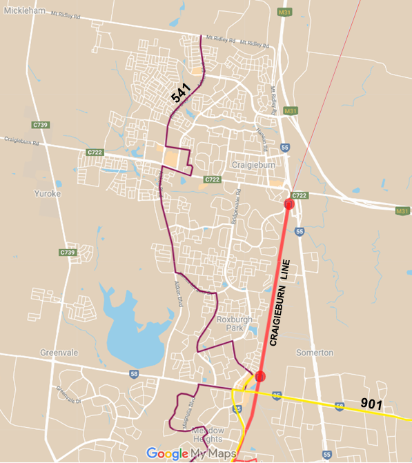
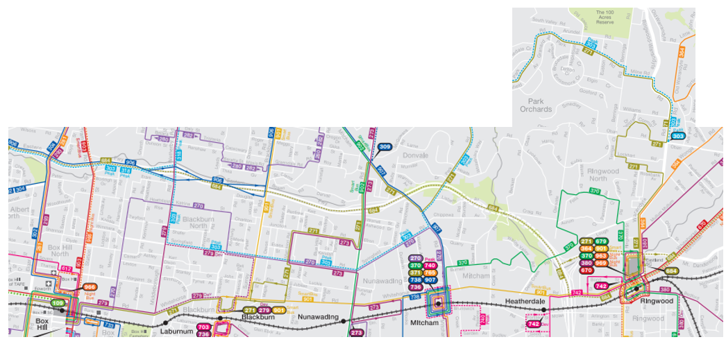
Today's route, the 271, is a bit like that. Operating from Box Hill to Ringwood it passes through a large area of normal suburban density near Box Hill, Blackburn and Mitcham before taking off into the greenery around Park Orchards. It then heads south again, via Ringwood North, to its Ringwood terminus. It starts in the electoral district of Box Hill (represented by Paul Hamer MP), then runs through Warrandyte (Ryan Smith MP), ending in Ringwood (Dustin Halse MP). 


It's the khaki line on the joined up local network map below (Visit PTV for the individual local government area maps at a better scale).  It's probably easiest to follow from Park Orchards in the  northernmost tab of the map. 


The photos below show two parts of 271's catchment. Left is a residential street in Blackburn. It's at close to normal densities for what is now middle-suburbia. 600 to 900m2 would be a fairly normal block size. However population ageing in some middle areas has lowered population density compared to when there were more children in the neighbourhood. On the right is Park Orchards. Its big selling point is large 'lifestyle' blocks within driving distance of jobs in the eastern suburbs and even Melbourne CBD. You'd need to be wealthy to buy a house here. And it would be rare for homes not to have at least one car per adult.  


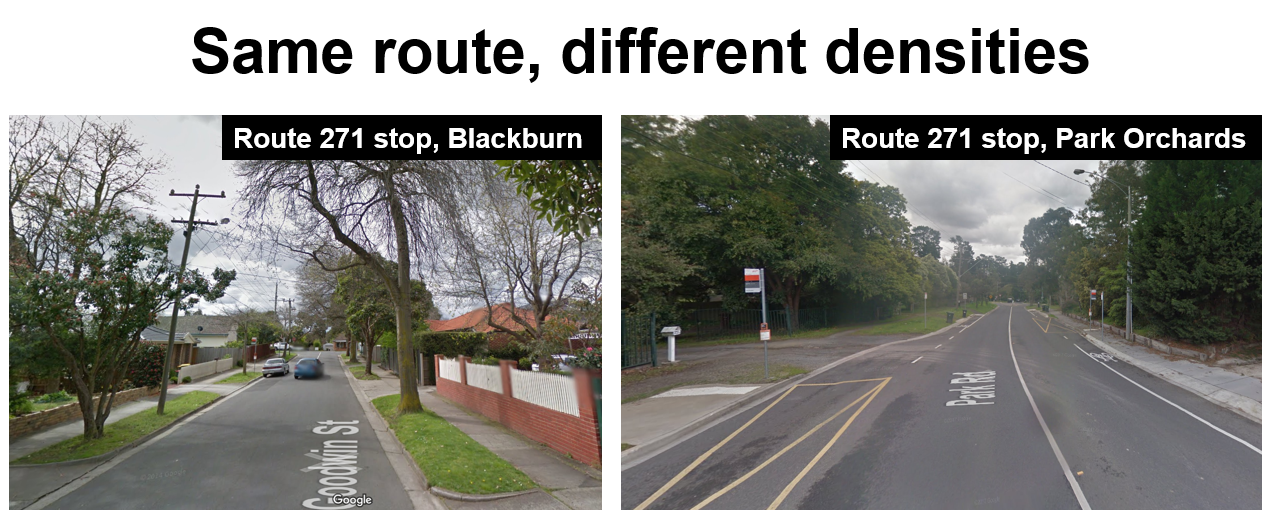
Not photographed is the western part of 271 along Whitehorse Rd. It has some commercial land uses. These include jobs that the route may usefully serve. Although the catchment doesn't look particularly productive (as it parallels a well-served rail line and there are other bus routes nearby) the Box Hill destination is convenient for a wide range of work, shopping, education and health trips. 

Knowing catchments is important because different neighbourhoods generate different levels of usage for public transport. A service level appropriate in one area may be too much or too little in another. With the large variations along it may be difficult working out what service level is right for 271. More on that next when we discuss the timetable. 

Timetable

Below is Route 271's timetable.  


Buses run approximately every 30 minutes, from morning to night, with a 20 to 25 minute headway during some peak times. A more even 20 minute service runs during the afternoon school peak  but only covers the early part of the commuter peak, with the 30 minute service resuming at 5pm from Box Hill. The Ringwood end has a better peak service, with the 20 minute frequency continuing until 6pm. However even this does not fully cover the pm peak, with city commuters needing to finish not much after 5pm to still enjoy the 20 minute frequency. 

The half-hourly schedule continues until 9:30pm - better than average for a Melbourne local bus route. Also superior is the weekday finish time with last trips in both directions departing at 10:30pm. Only SmartBuses and a handful of ex-Met bus routes (including 271) are still running this late. 


Similar to weekday service, Saturday service is every half hour. This makes it similar to the (sometimes overcrowded) SmartBuses on dense busy corridors like Route 900 (Caulfield - Chadstone - Oakleigh - Monash - Rowville). However 271's 8pm finish time is earlier than 'minimum standards' for local bus routes. 

This is because Route 271 can trace its history to National Bus routes, which were mostly omitted from getting 'minimum standards' upgrades that many other routes received in the 2006 - 2010 period. For the same reason Route 271 does not run on Sunday, despite its (arguably excessive) Saturday frequency. The route's last major restructure and timetable change occurred in 2014 as part of that year's Transdev network reforms

Conclusion

What would you do with Route 271? Does it overlap too many routes at the Box Hill end? Is it too indirect? And should some Saturday trips be moved to Sunday to provide an hourly service on each that might better match demand on both days?  If you have ideas please leave your comments below. 

See other Timetable Tuesday items here 

Sunday, July 28, 2019

5th anniversary of reformed Brimbank bus network


Comprehensive bus network reform is often talked about but too rarely happens. Especially in established suburban areas. Especially in Melbourne. 

Compared to other transport projects bus reform is cheap. And it potentially benefits catchments of millions whose nearest public transport is a bus. Politically though it's not seen as important as flashy infrastructure projects. And resistance from existing passengers, who tend to favour the status quo, can weaken interest, despite a new network's benefits. 

Public consultation and its limitations

Public engagement, especially face-to-face meetings, has problems of representativeness unless carefully managed. 

Local government,  stakeholder and community 'representatives', are often non bus-using professionals purporting to speak on behalf of their low-income bus-using senior, youth or disabled 'clients'. While well-meaning, what they say should be backed up by accounts from 'real passengers'. 

Even where attendees at meetings are bus users passenger samples can be skewed. There may be an over-representation of non-working time-rich older people and an under-representation of working time-poor younger people. So it's important to supplement town hall meetings with other means of engagement to get a fairer picture of community needs. Never choose meeting venues remote from frequent public transport, especially at night. And always ask 'Who is not in the room?'.

Consulting on the network, talking to passengers at train stations and bus interchanges can help. Though even that fails to reach non-passengers that a network redesign may benefit. So you might also wish to consult at shopping centres (where you will get both passengers and non-passengers) at various times. Online engagement is also handy, especially if users can be directly surveyed.

Opposition to reform


The time-rich organise petitions to scare politicians into keeping their (mostly quiet) routes while the time-poor fill, and are sometimes left behind by, the overcrowded buses they catch each day. Parents can also be vocal, with resistance to network changes that require their offspring to swap buses, wait at interchanges and/or use public instead of dedicated school services.


While public consultation, as mentioned above, risks not bringing out a fair sample of the community, not consulting can be even worse. When it gained the metropolitan bus franchise (offered by a Coalition government), Transdev, the winning bidder, thought it could introduce a more efficient 'greenfields' bus network with minimal opposition from PTV, the government or the community. 

Transdev succeeded with some (mostly good) network reforms in mid-2014. Also five years ago yesterday. Key changes included simplifying bus routes along the 200/207, 235/237, 250/251 and 302/304 corridors plus revisions around Ringwood (of less merit). You wouldn't dream of going back to the more complex routes of yesteryear, though crowding became a problem and some routes need more trips. 


Transdev's 2014 reforms were to be the entree for the main helping the following year. Their 2015 greenfields network had both big upgrades and big cuts, with the latter even on some busy routes. Perfunctory public information sessions were held before the changes. However it was not consultation and many passengers felt worse off. The new Labor government agreed and vetoed the entire Transdev change. Only minor changes have occurred to Transdev's network since.  

In contrast, the 2015 Wyndham and Geelong bus networks, planned in-house by PTV with public consultation, did proceed, not least because to have stalled would have meant new stations opening without connecting buses. These networks were quietly successful, though there were still localised objections that MPs would have seen.  

Wary politicians

These early experiences may explain why the first Andrews government and its transport minister, Hon Jacinta Allen, shied away from bus network reform. The government's then slim electoral margin (a problem it had in 2014 but not 2018) wouldn't have helped either. 

Today's stasis is a far cry from the expectations people had about 6 or 7 years ago when PTV was being set up. At least initially, this was not misplaced. Train reliability had rebounded from lows in 2010-2011. The Network Development Plan Metropolitan Rail promised upgraded frequencies on most lines. Transdev Melbourne was not the worry it later became. And patronage boomed on the new Point Cook bus network that started when Williams Landing station opened in 2013. 

Bus network reform in Brimbank


Five years ago yesterday, buses started running on reformed routes in the City of Brimbank, north-west of Melbourne. In an established area with no new train stations. In a safe Labor seat. Under a Liberal government. 

Sometimes governments do good things even when there are no electoral advantages for them. Or, perhaps more accurately, when there were no electoral disadvantages, as any seat in Brimbank is safely Labor. 

Unlike in Wyndham or Geelong the following year, most of the old route numbers remained the same. But all routes had changes to their alignment, frequencies and/or timetables. Some routes got replaced with new and more direct services. Network-wide 7 day service was instituted. And peak frequencies were upgraded on key routes. 

It wasn't without controversy as buses were removed from some streets. There were local newspaper articles and a petition presented to parliament (click for larger view below). 


The Hansard extract below is an answer to a question asked in parliament.  


This network reform is better documented than most. You can read more on the Bus + Coach Society website. And in this 2015 ATRF research paper here. But I will describe it briefly below. 

Pre 2014 Brimbank network

This is the old bus network in the City of Brimbank. Click on the map to enlarge for a better view. Note the following:

* Buses terminating in the middle of nowhere (routes 422 & 454)
* Many routes indirect or overlapping (especially around Kings Park, St Albans and Western Hwy)
* Single direction routes, especially in Sunshine West and Delahey
* Route 451 was duplicative and indirect but had the area's highest frequency
* Lack of direct main road bus route between Deer Park and Watergardens


Not obvious from the map were the timetables. Not all routes ran 7 days per week or much after 7pm. Some routes had frequencies that did not match trains. Or the service fell away on Saturday afternoons. Also off the map was the indirect and infrequent Route 460 which went an indirect way to Caroline Springs (via Hillside). That was a large population catchment with only limited service.

Post 2014 Brimbank network

The changes five years ago produced this network. Key features included:

* A two tier network, with direct main roads routes every 20 min and local routes every 40 min
* A new direct Route 420, operating every 20 minutes, from Watergardens to Sunshine
* A straightened Route 460 to Caroline Springs (mostly off the map)
* Improved directness of local routes, especially around St Albans and Sunshine West
* Replacement of old routes (eg 422, 451 and 454) with new routes (420, 427, 428)
* Simpler two-way running, with loops eliminated
* Improved coverage in some areas


All routes had 7 day service, including public holidays. Operating hours were also extended. In the case of Route 400 the longer hours reflect the fact that it now serves a residential area rather than it being purely an industrial / prison service as it originally was. Peak services were also increased to reflect high commuter demand from the area. Bus timetables were designed to harmonise with train headways and connect at designated stations. This however meant that some routes, such as 400 and 476, had their frequencies reduced at quieter times. Route 400, especially, has been a great success, with more commuters travelling to and from Derrimut on the improved peak service. 

Some outside Brimbank, particularly around Caroline Springs also benefited from this network. For example frequency upgrades for Routes 418 and 460 improved connectivity with the rail network. Some efficiencies came about as a result of better utilisation of buses around school times. 

The newspaper article above referred to the removal of Route 451 that ran between Deer Park South and Sunshine. It provided a handy one-seat ride at an unusually good frequency for a local bus route. The replacement direct 420 did similar but was beyond walking distance of some peoples homes. These residents would have had to catch a (less frequent) Route 423 (moved to replace 451) and change to a train at Ginifer, something that some found inconvenient. 

On the other hand the new 420, formed from the 451's resources, gave new southern connections to Watergardens that did not previously exist and greatly increased available routes and frequencies in underserved but high needs areas like Kings Park. It also helped Glengala Rd in Sunshine West, which gained a full two-way service and new connections to Deer Park and Watergardens. 

Subsequent changes

The changes five years ago were only the first phase. Others happened later. For instance revisions in the Caroline Springs area flowed through to Brimbank. Most notable was the simplification of routes along Ballarat Rd, with a new Route 426 and a rescheduled 456 providing an even 20 minute combined corridor connecting with trains at Albion or Sunshine. The 426 replaced the previous 216 that went all the way into the city (and beyond). Previously Ballarat Rd buses were confusing and unevenly spaced, rarely meeting trains. Busy Ballarat Rd now has a good service but the refusal to install pedestrian crossings limits direct and safe access to stops. 

Some routes gained increased service. Eg Route 460 gained increased frequency and an extension when Caroline Springs station opened. Service at one time was every 20 minutes but a subsequent timetable change made trips uneven, with 75 minute gaps. This is why it doesn't feature on the Useful Network maps. In addition Route 420 got weekend service upgrades and now operates every 20 minutes seven days per week (better weekend frequency than most SmartBuses but shorter hours). 

If you look carefully on the map below you'll see a reborn Route 422. It follows the same alignment as the original 451 but operates less frequently. There is very little unique coverage. Its existence is the result of local campaigning referred to before. Buses operate once an hour, like the restored Hope Street route 509 in Brunswick which was also restored after a similar deletion and campaign (though unlike the 422, there was no local bus network reform on the area).


Conclusion

The period about five years ago was very active in bus network planning. It was an era of new bus networks. Existing networks were reviewed with dramatic changes introduced. The result, in areas lucky enough to receive one, was a simpler network, better train connections, longer operating hours and higher frequencies on key routes. You can compare the simplicity of the above map with the complexity of unreformed networks in areas like Knox and Banyule (around Greensborough). 

The 2014 Brimbank and subsequent 2015 - 2016 Wyndham, Geelong, Epping North, Plenty Valley and Cranbourne networks marked a welcome departure from previous less efficient habits of simply grafting new routes over older routes with minimal change to the latter.

Latterly though, with a risk-averse state government generally uninterested in bus service reform, we've relapsed to the old ways, as seen with recent layered-on additions like routes 627 and (to a lesser extent) the 760 in place of the more comprehensive network upgrades we saw during a few 'golden years' of service planning.  The result is that much of Melbourne remains with unreformed  bus routes like 566 or 745 and the proportion of people near a good service is less than it could be.

 You might enjoy these well-regarded books on transport topics

Better Buses, Better Cities: How to Plan, Run, and Win the Fight for Effective Transit Steven Higashide NEW!

The Public City: Essays in honour of Paul Mees Gleeson & Beza

A Political Economy of Access: Infrastructure, Networks, Cities, Institutions (Access Quintet Book 4) David Levinson

Human Transit: How Clearer Thinking about Public Transit Can Enrich Our Communities and Our Lives Jarrett Walker

Transport for Suburbia: Beyond the Automobile Age Paul Mees

(Sales links: I get a small commission if you buy via the above - no extra cost to you)

Friday, July 26, 2019

Building Melbourne's Useful Network Part 13: Craigieburn


I try to be close to cost-neutral when discussing network reform on Fridays. This is to show that improvements are possible without spending much money, at least in some areas.  

However there are places such as the City of Greater Dandenong where buses are very underserviced despite a population keen to use them. Such areas might have disproportionately missed out on the 2006 - 2010 round of bus service upgrades. Or they might have population increases and other demographic shifts that result in full buses even if they come only every 40 minutes. 

People in Brighton or Eltham might be unexcited about using buses every 15 or 20 minutes but those in Tarneit, Point Cook or Springvale will crowd one that's half that frequency. These are the sorts of areas where you can buy five or ten buses, put them on existing (but preferably reformed or extended) routes and be confident they will be well used.  

Over two-thirds of Melbourne's bus network reflects history more than current need or the results of recent planning. Routes can run underused for decades, with no pressure to make them more viable or redistribute service to where it may be more needed. Overcrowding can be ignored, and comprehensive network reviews are rare.

Unlike as attempted and required for US cities, there is also no distributive justice for bus services in Melbourne. This is even though, unlike infrastructure-dependent train and tram services, routes and timetables can be changed with little more than the stroke of a pen. 


It's not even all a ridership versus coverage trade-off that Jarrett Walker talks about; historic maldistribution of service and overlapping routes mean parts of Melbourne exist where we should be able to achieve gains in both without having to choose either/or.  

Craigieburn has all the demographic signs that it is is one these high patronage potential areas. It's been growing fast for about 20 years. It is off-centre to the train line, with the new town centre and dense new subdivisions increasingly distant from the station. Although that by itself doesn't guarantee high patronage potential.

However Craigieburn does have packed-in family households on small blocks of land. 
Charting Transport maps show population density (especially parts of Craigieburn West) far higher than what we're used to with an outer suburb. In fact it is more like that of an inner suburb like Brunswick West. Not only that but while car numbers have exploded (due to growth) its car car ownership rate per adult has actually declined!

High population density, adults without cars and a
 young largely migrant-derived population in or seeking education and employment mostly outside their suburb. Where are they? On the buses!

Despite limited service there is heavy usage of the buses that do run . That's especially for Route 529 and to a slightly lesser extent Route 533. They're short routes so their patronage in absolute terms is nothing special. But when you look at the number of people who on average are waiting at each bus stop or on the bus there is high demand.   


Today I will not look too hard at overlapping and duplicating routes. That's because, unlike some established areas, not many exist (network map below). The key issues are lack of coverage, lack of frequency and limited operating hours, especially given modern travel and working patterns. 

All of Craigieburn is in the seat of Yuroke, held by Ros Spence MP. 


Outer suburbs aren't what they used to be

Before getting onto Craigieburn, we'll talk about outer suburbs more generally. Particularly those in Melbourne's north and west. 


The typical metropolitan outer suburb has changed greatly over the last 30 or 40 years. Blocks have shrunk. Houses are bigger (although some developments have townhouses and even apartments). Many are favoured by migrants, who in the 1960s and 70s would have settled in inner areas (unless they were English, who populated outer, particularly coastal, suburbs). Our foreign investment laws, which encourage overseas buyers to add to our housing stock by building new, may also be a factor. Especially if associated with migration later. 

Drivers of high population density in new subdivisions include high land prices, developers wishing to maximise yield, a price-sensitive market that wants the biggest house it can afford and more working couples that don't want a large high-maintenance backyard.  

Despite common wisdom that 'everyone needs a car to live in these parts' some of these areas, particularly those north and west of Melbourne, have lower than expected car ownership and well used bus routes. See the previous links for more discussion on this. 

Degentrification

We hear a lot about 'hipsters' and gentrification in inner suburbs. We don't hear as much about degentrification of outer suburbs. However the latter is quite common. You can see it visually in years since 1986 on this Charting Transport SEIFA animation . The changing fortunes of inner versus outer areas are quite evident.

While not always the case, many suburban estates are sold to homebuyers purchasing with a mortgage. A loan may require two earners on (say) $40 000 to $80 000 each. While these incomes are modest for some readers here, these and other attributes are enough to make an area rank middle to high on socio-economic status ranking systems like SIEFA.

Things change as a new estate ages. Original owners may have upgraded or moved on. Investors will have bought some homes for use as rentals. Tenants (on average) have lower incomes than owners, particularly in outer areas as high income tenants (especially without children) will prefer the lifestyle benefits of inner suburbs (whose low rental yields make renting much cheaper than buying).   

Even if people stay put their incomes may have fallen if one partner leaves or reduces paid work to have children. Relationships may split. Older (retired) parents may move to be nearer their adult children and grandchildren. Nearby employment areas like Broadmeadows may deindustrialise and lose good paying jobs. These all affect an area's SEIFA (an index based on multiple factors, most notably employment, income and formal education).

New estates may have poorer capital gain performance than established suburbs. This is particularly likely where block sizes are small and more of the original value is in the building (which depreciates). As people often like to buy in the 'best' area they can afford, reduced growth is likely to make fringe areas the only option for lower income buyers (since closer-in areas have appreciated beyond their reach). 

These are just some of the reasons for degentrification to happen as new estates age. Its extent varies. Some estates don't degentrify much while others can go from top to bottom in 30 years. Parts of Roxburgh Park and Craigieburn exemplify the latter. 

Effect on transit usage

Degentrification, where it affects education and workforce participation, may reduce trip activity from the home during peak times. Would this affect public transport usage? It depends.

Low SEIFA areas typically contribute few CBD workers. On average these people earn good incomes and are more likely to take public transport (notably train) to work. Such commutes may also involve a feeder bus leg. Fewer high income workers might be expected to reduce commuting.

Local jobs may not necessarily be in places or at times where convenient public transport operates, and parking may be 'free' anyway. That might depress public transport use. On the other hand lower SEIFA areas with more cost-conscious households may have more of them where not every adult owns a car. This benefits public transport usage throughout the day.

We are seeing a new generation of new, big, dense, young working migrant family suburbs like Tarneit and Truganina where bus routes are performing well during both peak and off-peak times. Weekend patronage is also healthy. Buses in parts of demographically similar suburbs like Craigieburn are doing the same. 

With few exceptions the service response from governments have been the same old 'bus every 40 minutes five to ten years after development'. That may have reflected past lower densities but doesn't match today's housing densities and working patterns. There is quite possibly a case for buses in newer dense suburbs to run every 20 minutes throughout the day, especially if their street patterns are supportive (which they are compared to 1980s 'spaghetti suburbs') and routes can be more direct and more widely spaced but retain good walking accessibility. 

Some of these 5 to 7 day/20 minute frequency routes and corridors do now exist. Usage varies, especially on weekends. Some around Cranbourne don't seem to do that well, possibly because they mostly only have one major destination. Those around south Morang also have quiet patches, possibly because they are two-route corridors (eg 386/387) and PTV is quite poor at explaining and selling the  higher combined frequency. However those in Werribee and Tarneit (which are demographically  more similar to Craigieburn than the other places mentioned) get good patronage throughout the week.

I explain the Useful Network concept here. It's those routes that are frequent enough and run over long enough hours to be useful for many trips. I've specified a 20 minute frequency on weekdays and 7 day service until 9pm. In other words the coloured lines on the Melbourne Public Transport Frequent Network map with the 20 minute frequency selected. This map shows the sparsity of Useful Network routes in most fringe areas, despite their sometimes high population densities. 


Existing Useful Network

That was a long preamble. What Useful Network routes exist now in Craigieburn? Not many.


Skirting the suburbs's east is the Craigieburn train line. Paralleling it, but serving the town centre and more central to development is the 541 to Broadmeadows. Its extension to Craigieburn North was fairly recent. The only other Useful Network bus in the area is the 901 orbital via Roxburgh Park.

There are no Useful Network bus connections from the station. Instead routes operate either every 30 minutes (ie not harmonised with trains every 20 min) or every 40 minutes (less frequent but harmonised with trains). Use is understood to be particularly high on Routes 529 and 533. Both operate every 40 minutes with the 529 running every 15 minutes during the morning peak.

Expanded Useful Network

If you wanted to quickly boost service on the busiest routes you would just increase 529 and 533's interpeak frequency from every 40 to every 20 minutes. Ideally this boost would apply on weekends as well. Longer operating hours would also be desirable given the area's population density and distance from trains. No more buses should be needed as both routes already run every 20 minutes or better during peak periods.

A better approach is to review bus routes given coverage gaps. The existing Route 529 could be bulged west to unserved areas but this makes it less direct for some trips if you were to keep its existing terminus at Highlands Shopping Centre. Reduced directness would make some existing trips slower, including some from densely populated areas.

This is particularly topical for Craigieburn because (apart from density) it is everything that good transit-oriented planning isn't. For example the new town centre was built remote from the station, leaving the existing smaller shopping centre near the station to struggle. That centre's decline means that people will need to choose between being walking distance to a station or walking distance to a good shopping centre, instead of having both. Without a low car housing option in Craigieburn (which even Roxburgh Park has near the station), households will buy more cars, drive them further and use active and public transport less. 

Much like outer Adelaide where train stations tend to be at the back of everything, population density in Craigieburn rises the further away you get from the station (particularly westwards). And, as you can see from the picture below, there are settled small-block subdivisions with no bus service at all.


The solution to poor coverage is to add and/or lengthen routes. This improves directness and journey speed as each route doesn't have to go to as many places for the network to have reasonable coverage. You can see this in the Point Cook example below, where Routes 494 and 495 are about as direct as the road network allows. Both routes are well used, particularly 495.


As well as improved coverage to the west, a case exists for an eastern connection to Epping (eg by extending 357 to Craigieburn) and possibly a south-western connection to Mickleham Rd (eg by extending 543 to Craigieburn). While these would allow easier access than exists now, development is not yet continuous. As you'll see on the map later, I have these extensions as thin (less frequent) lines rather than thick Useful Network routes. However that might change with future development if Craigieburn gets something like a SmartBus orbital.

Major roads to the west are now long enough to justify direct services rather than current routes that loop inwards or dead end before development finishes. Also worth noting is Labor's pre-election promise of a Craigieburn - Wollert - Mernda bus route last year.

Below is a potential expanded Useful Network (thick lines). Local routes are shown in thin lines for context as some are extended or rerouted.


View it with caution. It's a growing area and some alignments would likely change. Maybe there are too many Useful Network routes. Although if population density is twice as high, it is not unreasonable that buses run twice as frequently (or better). And the area's existing route (the 529) is very well used. So I throw a lot of service at Craigieburn West. I'll discuss each route in order of priority so upgrades can be phased in over time.

Route 529

This is top priority. It is already very busy. I try to kept it fairly similar to now. However I have extended it west via Brookfield Bvd (subject to the road existing) and broken its connection with 533. That was a cost of the increased coverage, which as you saw from the large unserved area before, is very necessary. It serves a dense area. So I suggest a 10 - 15 min peak frequency, 20 minute interpeak service (including weekends) and a 30 minute night service to match. Longer operating hours are desirable since the area is so far from trains.

Route 533/535 pair

Route 533 is an existing route. Route 535 is an added route. Ideally it would be numbered 532 or 534 but these numbers are taken. 533 and 535 would form a through-routed pair similar to the successful 494 and 495 in Point Cook. In other words all Route 533 trips, on arriving at the terminus, would continue as Route 535. And vice versa.

Where one of those routes serves a major shopping centre (as 535 would) this through-routing would give passengers on the 533 one-seat trips to and from it by riding through the terminus. Also those on Highland Dr have the option of catching either 533 or 535 from the station, effectively doubling the service frequency available.

Routing through termini is a good approach in fringe areas like Point Cook South and Craigieburn West where there is no logical end point such as a railway station or shopping centre. Because it produces two L or U-shaped routes this is more direct than confusing loop routes, which may sometimes have numbers in each direction (like 681 and 682) or single numbers (like 443 or the horrid and unforgivably new 380).

The 533/535 round trip is just over 15km. Because local buses travel at about 22 - 25 km/h, it should be able to complete it in just under 40 minutes, particularly during off-peak times. This route length is efficient for the 533's current 40 minute frequency, which meshes with every second train at Craigieburn. If you were going for a 40 minute frequency you would offset trip departures by 20 minutes at the station to provide a higher frequency for those in the west who could use either route (also done at Williams Landing for 494/495). However, because of population density, I've suggested the pair run at a 20 minute Useful Network frequency, at least on weekdays.

Route 544

This currently runs every 30 minutes between Roxburgh Park Station and Craigieburn Station. One of Roxburgh Park's first routes, it commenced before the Craigieburn Town Centre was built. Because it already connects to a train at Roxburgh Park and the northern part of the route is near the newer Route 528 to Craigieburn Station, I have suggested operating it to the town centre at Craigieburn instead of the station.

Then there's the 30 minute frequency, which doesn't harmonise with trains. This means the same pattern of connections repeats only every hour. And if you are trying to connect with a bus every 40 minutes, the repetition is every 2 hours. One could drop its off-peak frequency to 40 minutes. Or raise it to 20 minutes to make it a Useful Network route, at least on weekdays. I've opted for the latter but it is a lower priority than the others. My thinking is that Roxburgh Park and Craigieburn stations are nearly 4km apart and the 544 provides significant unique coverage distant from the 541.

A potential option, desirable of further study, is to extend Route 544 to the south-east to better serve jobs in the Somerton Park Industrial Estate. Together with its rerouting to Craigieburn Town centre this would improve access to jobs for Craigieburn West residents who would gain a same-stop connection from the new route 535.

Other routes

Craigieburn currently has no east-west circumferential routes outside its local area. And there is no direct bus from Greenvale to the Craigieburn Town Centre. Extensions to local routes 357 and 543 are drawn to cover these off.

The map shortens Route 537 due to the extension of other routes (535 and 543) in its area. And alters its off-peak frequency to 40 minutes to mesh with trains. Similar is suggested for Route 528. While this is a frequency drop, many areas will gain from the new 535 and upgraded 529.

For more information click on the interactive map. You can switch on and off existing and expanded Useful Network layers.


Service upgrade summary for Craigieburn (most important first)

1. Extend existing Route 529 to improve coverage. Upgrade to operate every 20 minutes off-peak, with longer operating hours and a better peak service to reflect its current high usage.

2. Create a new route pair comprising Route 533 and new route 535, with trips operating through the terminus. At least every 40 minutes but preferably every 20 minutes.

3. Reroute 544 to serve Craigieburn Town Centre and potentially upgrade to every 20 minutes to make it a Useful Network route coordinated with trains at Roxburgh Park.

4. Various extensions and rescheduling of local routes (involving 357, 528, 537 & 543) to enable east-west travel and connections with trains.

Conclusion

A more useful bus network for Craigieburn has been presented. With few efficiency offsets, it will cost more buses, more drivers and more money. However population growth have far outstripped service growth. 

And, as demonstrated by  high patronage on local routes such as the 529, the area has the demographics and potential for further patronage growth. This is a work in progress and further improved service on more of corridors only partially upgraded (eg Craigieburn Rd) will be needed as the area grows.

What do you think? Is it too much? Or too little? Please leave your comments and ideas below.

PS: An index to all Useful Networks is here.

Tuesday, July 23, 2019

Timetable Tuesday #32: Route 624 - via Murrumbeena or Malvern East?

Some bus routes need just a glance to work out what they are about. It could be a simple circumferential link between train stations on different radial lines. Maybe something between a station and shops, serving homes on the way. Or possibly a radial that starts in the suburbs and heads inwards to a train station or the CBD.

That isn't true with Route 624 between Kew and Oakleigh via Caulfield and Chadstone.  The map below (not to scale) doesn't help a lot either. 


It's simpler if you plot it on a to-scale map pieced together from three PTV local area maps (shown below).


The westernmost part of the 624 is a north-south connection from Kew to Caulfield. It joins three train lines and multiple tram routes. While neither Auburn nor Tooronga stations are major, the route is walkable from Swinburne University/Swinburne TAFE to the west and Camberwell to the east. 624 also goes near many private schools that attract students from long distances. Trams provide other north-south links but none start at a station (or destination) as significant as Caulfield like the 624 does. As logical as a Route 72 southward tram extension to Caulfield might look on a map, the 624 bus is the nearest to it we've currently got.

Approaching from the east is the Chadstone to Oakleigh section. Unlike other routes this takes the long way around via Huntingdale Rd. It's not direct. But it doesn't need to be as it provides some useful local coverage other routes don't. 

Then there's 624's middle. That's the confusing bit. On weekdays about half the trips go via Murrumbeena and Carnegie with the other half via Malvern East and Darling. On evenings and weekends all trips operate via Murrumbeena and Carnegie.  

The Malvern East variation runs along Dandenong Rd. It used to just follow the 623. The more frequent 900 SmartBus was introduced over the top of both in 2006. However no changes were made to either 623 or this variation of the 624 despite the overlap. The hourly weekday-only Darling Rd portion has no overlap. However it goes an indirect way to Caulfield and is poorly used. All homes in the area are near trams or Glen Waverley line stations.


The 7-day Murrumbeena - Carnegie variation used to run via Dandenong and Koornang Rds (overlapping the 623) until it was sensibly changed about 15 years ago to serve the Murrumbeena portion of Neerim Rd (not previously served). However it still overlaps 623 along Neerim Rd west of Koornang Rd before looping around to Caulfield. It's quite confusing as there are Route 624 stops on both the north and south side of Caulfield Station. 

To summarise, 624 is really multiple routes that just happen to join together and share the one route number. There's a simple useful north-south portion between Kew and Caulfield, a less simple but still useful portion between Chadstone and Oakleigh, and, in the middle, two duplicative and less useful sections between Caulfield and Chadstone. 

Patronage is quite high seven days per week.  School children heavily use some weekday services. And despite the low frequency, weekend usage is high due to the route serving Chadstone Shopping Centre.

As expected with a route of this length and complexity, the 624 serves multiple state parliamentary seats. These include Hawthorn (John Kennedy MP), Malvern (Michael O'Brien MP), Caulfield (David Southwick MP), Oakleigh (Steve Dimopoulos MP) and Burwood (Will Fowles MP).

624's timetable

A 624 timetable is below (other direction is similar). Operating hours meet the post-2006 standard for Melbourne buses - ie a Monday to Sunday service finishing at 9pm. Some finishes were previously earlier  but extra trips were added not long ago. 

The route's basic daytime frequency is 30 minutes, with services alternating between Carnegie and Malvern East for an hourly service on each. Weekend service is hourly, with only the Carnegie portion served. 


History

Some history on the 624 appears in my post from 10 years ago. The old 627 got fixed (and the number recycled for a new route this year) but nothing's changed with the 624. Krustylink also has some history but do check at other 62x series routes as they were chopped and changed a lot. 

Conclusion

624 seems to have good and bad bits. What do you think should be done with it? Should it be split into different routes, and if so, where? Do parts justify a better service than runs now but should other segments be dropped? And are there things you could do with other nearby routes (eg running the 623 via Neerim Rd or extending 734 to Caulfield) that could help simplify 624? Comments would be appreciated and can be left below.

See other Timetable Tuesday items here 

Friday, July 19, 2019

Building Melbourne's Useful Network Part 12: A new 281 Templestowe - Box Hill frequent corridor for next to no cost

It's always good getting service improvements for free (or almost). Too good to be true? Read on!

When the new orbital SmartBus routes started about ten years ago regular bus routes were only sometimes changed. Changes let regular routes be simplified and service to be transferred to places away from the SmartBus corridor that needed it. For example, what happened in Carrum Downs when the 901 commenced

We didn't get (as much*) similar reform in a long strip from Eltham through Templestowe and Doncaster to Box Hill. Consequently, despite parallel and sometimes overlapping orbital routes, a route like the 293 was left unchanged from 30 years ago (see 1992 network map - it was the 269 then).  

Overlaps mostly involving the 293, some many kilometres long, are below: 


'Good' overlaps

Route overlaps work well where bus routes are the same frequency and are evenly staggered to provide a more frequent combined service in an area that justifies it. An example is the Elgar Rd corridor between Box Hill and Doncaster via major hospitals and a TAFE. On weekdays routes 281 and 293, thought not immediately apparent, provide a combined 15 minute service.

That's a 'good' overlap, provided people know about it. As a multi-route corridor it needs to be well scheduled and communicated through sensible route numbering, signage and multi-route composite timetables. 281 and 293 don't fully meet this requirement. 

This is partly because Public Transport Victoria, the staid government agency responsible for passenger information, lacks a pro-patronage business culture that promotes good stuff like frequent service. Their information to users is often unrefined, for example with bus stops listing trips along the same corridor by route rather than chronologically (that would emphasise frequency). More advanced cities explain transit service in terms of place, network, frequency and connections rather than the mode, operator and route bias common here.

It's important for routes to be simple if we aren't good at explaining them. Simplicity is also good if we are good at explaining. Then time can be spent promoting benefits to drive patronage growth. Our recent record on this isn't good with stagnant bus usage despite a growing population. 

Other things being equal a single frequent route is more sellable than two less frequent routes, even if their times are evenly staggered over a common section. Transperth has been consolidating their inner city routes in this manner, making the service easier to use.  Hold that thought as we'll return to it later. 

'Bad' overlaps

So much for 'good' overlaps like 281/293. There are also 'bad' overlaps. These put frequency in sparsely populated areas that don't need it. Frequency costs fuel and driver hours. We need to be careful where to have it so that the most people benefit.

The overlap maps above include examples where frequency is probably wasted. Sparsely populated roads in Lower Plenty and Eltham get six to eight off-peak trips per hour despite other corridors like Bolton St having no service. Trips are unevenly spaced and rarely harmonise with local trains every 20 minutes.

If we were reviewing the whole network one might question having two, rather than one, SmartBus routes. And Route 513. That needs a wider look. I'll leave them alone today.

The 293

However I will discuss Route 293 that runs every half hour. It was the only cross-river route before the SmartBuses came. Today's 293 timetable is similar to that which ran in the past, down to its hourly Saturday service and 2-hourly Sunday frequency. It contributes to the overlap you saw on the maps above and pictured below (Main Rd, Montmorency). 7.5 buses per hour operate along this low-density stretch.


Further south Route 293 runs along Williamsons Rd. Again there's not much catchment and overlap with other routes, including two SmartBuses (901 and 902) in parts. Buses run here at midnight while far denser corridors, including major highways like Princes Hwy and parts of Nepean Hwy, lack anything much after 7pm or on Sundays.


The 281

Meanwhile, a short distance to the west, and parallel to Williamsons Rd, is High St Templestowe (below). This is populated at nearer to regular suburban density. There are two bus routes in this section. The 309 is an occasional city peak route. 281 is the regular service. It runs every 30 minutes on weekdays and 60 minutes on Saturdays. There is no evening or Sunday service. High St deserves more than it has.


The southern part of the 281 joins the 293 from Doncaster Shoppingtown to provide a combined 15 minute service down Elgar Rd to Box Hill via hospitals. This is a useful corridor for frequent buses to run down. On weekdays Route 281 continues to Deakin University every half-hour. It roughly parallels other routes from Box Hill including 201 and 768 (both duplicative university shuttles).

293 and 281 summary

The map below shows both routes 293 and 281. Key points to note include 293's overlap with other routes for 90% of its length and the combination with Route 281 between Doncaster and Box Hill. 293 operates 7 days per week. The busier but shorter Route 281 operates 6 days per week.

The 582

Another route in the area is 582. It's a unidirectional loop route serving areas east of Eltham. The unidirectional direction means a longer than necessary journey from some places. Its 20 minute 7-day frequency is unusually high given its catchment and low weekend usage. This is particularly the case on Sunday mornings where, at 7am, it runs twice as frequently as trains on many busy lines.


Why did I bring up the 582? Keep reading as it's important for what we're trying next.

A new frequent corridor

Route 293 appears redundant. It contributes no unique coverage. It overlaps more frequent routes. While it provides a one-seat ride between Box Hill and Greensborough, these centres are quite distant from one another. And there are frequent alternatives including a change to a train at Heidelberg or a change to the 902 bus at Doncaster. Eight direct buses per hour operate between Box Hill and Doncaster, with four to Greensborough. The existing 293 was only two buses per hour, with much less service on weekends.

Route 281, in contrast, appears underserved. It has an early finish and lacks Sunday service, despite its good patronage.

The logical step could be to delete Route 293. Most of its resources could be put into doubling 281's frequency. In other words to make it every 15 minutes on weekdays and 30 minutes on Saturday. 281 has no Sunday service. Transferring 283's resources would give a 120 minute frequency. But ideally it should be every 60 or even every 30 minutes. This 281 upgrade would provide a simple north-south service between Templestowe, Doncaster Shoppingtown and at least Box Hill. It would also simplify access to the hospitals and TAFE.

Deleting the 293 would mean that some stops in Montmorency would no longer be served. This is where 582 comes in. Instead of being a circular loop feeding only Eltham, the route could be extended to Greensborough via all 293's existing stops in the area. The 40 minute frequency would better connect with trains at Greensborough (compared to the 293's 30 minutes).

While the new 582's frequency is lower it would better suit the catchment, with the bidirectional running between two train stations providing more connection opportunities. There could be higher weekend frequency compared to the 293 and longer operating hours compared to both routes.

Service kilometres and operating costs would be similar to now, with higher frequency and simpler routes compared to now. Electoral districts to benefit include Templestowe, held by Matthew Guy MP and Box Hill, held by Paul Hamer MP.


Conclusion

Overall, deleting the 293 allows better local connections. These include (i) between Templestowe, Doncaster and Box Hill through an upgraded 281 and (ii) improved access to Greensborough from eastern part of Eltham. Greensborough is the major suburban centre in the area and is a stronger destination than Eltham that was previously the only choice available to 582 users.

The area east of Eltham has been removed from the 20 minute network. It's too sparsely populated to justify the 7-day frequency it now has. However it still deserves a wider range of destinations, bidirectional service and longer operating hours to make buses overall more useful.

Adding to the Useful Network is the upgraded 281. Its 15 minute weekday frequency and improved weekend service should be better for more trips, with a simpler service on the busy Elgar Rd corridor.

What do you think? Is this an improvement? Please leave comments below.

(*) Though there was some reform - see comment below.

PS: An index to all Useful Networks is here.