Thursday, July 28, 2022

Feedback from the Future Frequent Network

Some great reactions to and feedback from the Future Frequent Network I described yesterday. Read it if you haven't already. And browse the interactive map. Not just the FFN routes but also the simplified 'Useful Network' routes too. If you want to refer to it quickly from the blog there's now a direct link. 

Today I wanted to showcase two early suggestions received for network changes. Both are for more frequent network routes. I won't add them to the map straight away as I was working to an approximately 900km network length and the suggestions add more kilometres than they'd remove. 


1. Williams Landing - Deer Park and Caroline Springs or Watergardens

While the FFN map had several long 10 minute frequent corridors in the east between the Frankston or Dandenong and Ringwood lines those in the west were much shorter. This was deliberate and due to development patterns. 

Whereas the east is mostly more continuously built up (except for the Carrum Downs - Dandenong South part of the 901) this is not so in the west. Palmers Rd for instance has a lot of large scale warehousing or light industrial type uses. I did not see this as generating the sort of dense all day / all night / all week activity that justifies a frequent bus. 

The Useful Network (finer lines) adds significant cross-town routes that don't currently exist or run to weaker termini but at lower (eg 20 min) frequencies. That would greatly improve mobility compared to now. But not with the sort of turn-up-and-go frequencies on the FFN routes. 


2. Craigieburn - Coburg North (19 tram terminus)

The Sydney Rd corridor is a main one for road traffic but is fragmented if anyone tries to catch public transport up it. Both the 19 tram and the Upfield line have weak termini. There is a strong public transport using population in the Craigieburn area. The area around Hadfield has local access issues such as buses not running 7 days per week and poor connections outside the area including to the east (eg Reservoir) and north (Broadmeadows). 

The FFN seeks to address some with new frequent routes in Craigieburn and across to Mernda. A rerouted 902 and a station at Campbellfield would improve access to Melbourne Airport. Improvements  or extensions to local routes like 532 and 536 would improve connections such as Craigieburn - Upfield, Hadfield - Broadmeadows or Fawkner to Reservoir. Those making trips from Craigieburn to the Sydney Rd corridor would benefit from three east west bus routes serving Craigieburn line stations. 

One concept suggested was effectively a TramLink bus from the 19 terminus to Craigieburn. It certainly wins for directness. Say an extension of the 531 bus. The nearest parallel to this is the 732 Knox Transit Link in the east which connects with the 75 tram at Vermont South. Like the 19 tram it has a lot of destinations and activity along it. But the 732 Transit Link doesn't get a lot of use (although the longer 732 itself does). 

How do you think an extended 531 every 10 minutes would fare? Noting it would overlap much of the existing 532. Would it provide needed connectivity with east-west routes (especially without there being a station at Campbellfield) or is the catchment too weak? And if you did like the idea which other route would you prune back or modify? 


Conclusion

Two ideas for an improved Future Frequent Network have been suggested. What do you think? Would usage and network role justify a top tier status? I don't want it to 'grow like Topsy' so I'll suggest if you do endorse extensions you also nominate weaker parts that could be pruned back. Please share ideas in the comments below. 

Wednesday, July 27, 2022

UN 135: The Future Frequent Network Melbourne needs?


What if you had a task to economically bring good public transport to the most number of people? Rail is a needed backbone in a big city, but to reach the most number of people and jobs good buses are equally necessary. Their routes need to be simple, direct and frequent to attract widespread usage. The nearest routes to this ideal are our eight SmartBuses. 

Last week Melbourne University's John Stone and Iain Lawrie proposed a 'Clean Slate' frequent bus grid for Melbourne's west. This, and earlier RMIT work from 2020, was based on Paul Mees' 'Squaresville' concept from Toronto. The authors envisage it as a thought experiment to show the potential accessibility gains from a grid style bus network in western Melbourne. Then on Tuesday the Victorian Greens proposed a grid network of electric buses without details of routes or frequencies.   

Last Friday I mentioned the power of maps, with particular reference to the freeway maps in the 1969 Melbourne Transportation Plan and, more recently, the Suburban Rail Loop. More than words they communicate visions and raise expectations. Maps that resonate can even make money appear.   

2021's Victoria's Bus Plan correctly identified many issues with buses. But, like the Greens' plan, it lacked maps. The previous plan of substance, 2006's Meeting our Transport Challenges did have maps. One map showed existing and planned SmartBus routes up to Stage 3 while another identified 'Principal Public Transport Network' corridors in a Stage 4. 

State government planners in 2006 envisaged that a complete SmartBus network would have more than 900km of cross-town connections. On Sunday I used their PPTN map to make a list of potential routes in such an enhanced SmartBus network


How does that 900km network compare with what runs now? Out of today's 350-odd bus routes eight of  them (900, 901, 902, 903, 905, 906, 907, 908) are SmartBus; a number that hasn't changed in over a decade. To this should be added five non-SmartBus routes (216, 220, 223, 234, 246) that offer SmartBus equivalent service. Parts of 200/207, 250/251, 302/304 and 732 also qualify. All up it's 485km worth of SmartBus-type service on 17 route corridors. Route 703 was a SmartBus pilot but never gained full SmartBus operating hours so is excluded from the total. 

SmartBus refreshed: Welcome to the Future Frequent Network!

First-cut 'Squaresville' networks are just lines for academics' projections. Some lines traverse sparsely populated areas while others fail to efficiently connect people with where they want to go. Modified refined 'Squaresville' networks are more practical, working well in continuously settled cities with grid road networks including Toronto and much of Melbourne.  

The 2006 PPTN was more allied to activity centres but routes weren't clear. Besides it was drawn 16 years ago. Melbourne has added over a million people since. Therefore it's high time for a 2022 version. Especially with an election coming up and various parties preparing their pre-election pitches. 

I've called it the 'Future Frequent Network'. And, heeding my advice, there will be a map! 

How many route kilometres would the FFN have? 2006 planners aimed for 'over 900 kilometres'. Today 1200km would not be unreasonable, given subsequent population growth. But there's a catch.

Melbourne's SmartBus' service levels compare poorly with top tier bus routes in Sydney, Brisbane and Perth. This is mostly due to their 30 minute weekend frequencies. Other issues include evening frequencies and the 9pm Sunday finish on most routes. 15 minute weekday waits, even in peak, are also not ideal for major routes in a big city and do not constitute 'turn up and go'. 

Consequently I will recommend a smaller but more frequent network of around 950km. As many as possible routes would run every 10 minutes or better during the day (7 days) with 20 minute maximum waits at night. However many areas away from the Future Frequent Network could still gain through improved local services with a 7-day 'Useful Network' operating every 20 minutes or better over long hours.  

Without more words, here's the Future Frequent Network, presented as an interactive map. Click top right to enlarge and click left to show or hide various layers by mode and frequency.  

Want to compare this with the service your area currently gets? See the Melbourne Frequent Network Maps for existing service levels by day of the week. The improvements in many areas are massive! Prefer a fixed map? Just scroll right to the bottom.

Notes

* Most bus routes will be familiar but some are made longer or shorter. Others are new or changed to provide improved directness and frequency to more people and places. The number of bus route corridors with frequent service almost triples from 17 to 45. While the total kilometres involved doubles from 485 to 963km (excluding the weekday-only university shuttles).  

* Thick lines are Future Frequent Network routes. Thin lines are notional Useful Network routes typically every 20 minutes or better. Again some are existing while others are new or reformed. Click on the line for more information. 

* Complementary train and tram timetable reform is desirable to better connect with buses and make the Future Frequent Network truly multimodal. The main components of these include 'greenfield' Metro train timetables to upgrade frequencies to 10 minutes day/20 minutes night and tram network reform to boost widespread 12-15 minute frequencies to 10 minutes. Since it got upgraded in 2021 the Frankston line timetable sets a desirable template for trains.

* New train stations at Paisley and Campbellfield would enhance network connectivity in areas where the grid is coarse or broken. Other than that no rail or tram extensions are assumed, although the FFN will maximise benefits from 'Big Build' projects. Bus, workforce, depot, interchange requirements, and other matters will need assessment as part of planning. As will some exact route alignments and choices for the FFN. 

* Roll-out can be done in stages over a multi-year program (say 5 to 8 years). Significant parts (eg getting to 15-20 min maximum waits) can be done without additional bus purchases - only more funded drivers and service kilometres. Widespread roll-out of 10 minute frequencies will however require more buses as will local route upgrades, especially in growth areas.

* The 2022 Victorian State budget allocated $847.5m for 129.3 million bus service kilometres in metroplitan Melbourne BP3, p335). A 25% increase in annual bus service kilometres (proportionally similar to that delivered under 'Meeting our Transport Challenges' between 2006 and 2011) could deliver a large proportion of the Future Frequent Network. This would represent a fair catch-up as we haven't had a new SmartBus route in over a decade and we have grown by over a million people since. 

Many winners across Melbourne

On a gains per dollar basis few public transport projects would exceed that provided by a Future Frequent Network like that described above. It will vastly improve 7-day mobility across and around Melbourne. The map below gives a snapshot of the big uplift in 7 day service every 20 minutes or better on key routes. The extent of service every 10 minutes or better would rise by an even greater amount. 

FFN would maximise or bring forward benefits from State Government 'Big Build' projects such as level crossing removals, the Metro Tunnel, Airport Rail and the Suburban Rail Loop. Particular examples include the Sunshine - Melbourne Airport bus and the SRL SmartBus between Box Hill and Southland/Sandringham. 

The Future Frequent Network would be a step change for public transport in outer Melbourne, especially if train frequencies are also improved. Currently just three SmartBus (or equivalent) bus routes run outside the M80 or east of Stud Rd. The FFN boosts that to over 20.   

The above map concentrates on the route and service aspects of an upgraded bus network. However targeted infrastructure investments such as bus wormholes would speed travel in key locations. There are also large growth areas distant from rail. Potential may exist for busways to provide rapid transit in these parts. Potential corridors could include Taylors Rd, Wollert and Clyde Rd. The FFN adds frequent routes on these corridors (routes 418, 360 and 899 respectively) to assess potential demand that could justify larger works. 

Route summary (long: feel free to skip)

The following list potential Future Frequent Network routes. Most existing SmartBus corridors are included plus many more. Routes in green already have high service and need relatively few (if any) additional resources. Those in yellow need significant extra hours with existing buses for better span and frequency. Those in pink need both hours and extra buses. All but university shuttles would operate 7 days per week until midnight with frequent service. 

150 Tarneit - Williams Landing - Point Cook South 20km A joining of existing 150 and 497 to give a north-south through route. Improved in frequency due to high patronage and large catchment in Truganina area. A cut down version could just operate as the existing 150 (10km).

165 Manor Lakes - Werribee Plaza - Hoppers Crossing - Point Cook - Laverton 25km  East-west route incorporating existing 166 and 498. Fills need for legible east-west connections from Point Cook. 

170 Tarneit - Werribee Plaza - Werribee - Wyndham Vale 16km Joining of existing 170 and 190 at Werribee and boosted frequency and hours. Joins major centres and train stations in Wyndham with more frequent service. 

201 Box Hill - Deakin University 5km Existing unchanged shuttle. Upgrade funded in 2022 state budget. Some background here.

200/207 Kew - City 13km Unchanged existing route pair with frequent service on combined section.

216 Sunshine - Melbourne 13km Unchanged existing route with already frequent service.

220 Sunshine - Melbourne 15km Existing route with already frequent service. Straightened to run along more of Ballarat Rd in conjunction with reform to Route 410. Potential future Megabus or light rail corridor

234 Garden City - Melbourne 7km Unchanged existing route with already frequent service. 

246 Clifton Hill - Elsternwick 13km Unchanged existing route with already frequent service. 

250/251 Northcote - City 11km Unchanged route pair with frequent service on combined section. Minor increases in operating hours. 

301 Reservoir - La Trobe University - Macleod 7km Existing weekday only shuttle extended to Macleod to provide a fast connection to La Trobe University from two rail lines. 

302/304 Mont Albert North - City. Unchanged existing route pair with frequent service on combined section. Minor increases in operating hours needed.

360 Wollert - Epping - Greensborough 20km NEW Fast route providing fast and direct service in Wollert area. Replaces portion of 566 and 901 between Epping area and Greensborough. 

375 Airport West - Broadmeadows - Roxburgh Park - South Morang 28km Replaces Airport West portion of 902 orbital and northern part of 901 orbital. 

390 Craigieburn North - Craigieburn - Doreen 28km Existing route with extensions for more residential catchment and upgraded frequency/hours. 

401 North Melbourne - Melbourne University - Victoria Park 6km Extended to Victoria Park incorporating Route 202 to provide east-west connection every 10 minutes. Currently weekday only but consider need for weekend service.  

402 Footscray - East Melbourne 8km  Existing unchanged route with upgraded hours and evening / weekend frequency. Intersects with many north-south trams with high use for local trips. Potential extension to Jolimont or Parliament. 

406 Footscray - Highpoint - St Albans 21km Existing popular route made more direct in Maribyrnong area and extended to St Albans with local route reforms to retain coverage. Improved frequency and hours especially Footscray - Highpoint. Done in conjunction with Essendon - Highpoint - Sunshine SmartBus rerouting (see 904 below). More detail here.

411 Footscray - Altona North - Laverton 24km Existing route greatly upgraded in service to operate as replacement for the Millers Rd 903 SmartBus with a strong connection to Footscray and improved service in Altona North. Introduced in conjunction with reforms to local routes. Would connect to a rebuilt Paisley station, improving local connectivity. Background here.

418 Rockbank - Caroline Springs - St Albans 19km Existing route extended west along Taylors Rd to serve Aintree with a high quality service. This route is Stage 1 for Taylors Rd to be a potential North West Bus Rapid Transit corridor. Ultimately it could feature multiple frequent routes one of which may extend east to a potential Keilor East station on the Airport line. 

420 Sunshine - Deer Park - Watergardens 16km Existing unchanged route with upgraded hours and frequency. Has significant unique coverage and strong demographics that would value improved services. Also strong feeder for emerging Deer Park transport hub. 

450 Weir Views - Melton Station - Woodgrove Shopping Centre - Coburns Rd - Kurunjang 12km New route to deliver frequent and direct service in area. Introduced in conjunction with Melton town network review. Current bus services in Melton are infrequent and indirect. 

455 Cobblebank Station - High St - Woodgrove Shopping Centre - Bulmans Rd - Melton West 12km New route to deliver frequent and direct service in area. Introduced in conjunction with Melton town network review. Current bus services in Melton are infrequent and indirect. 

460 Watergardens - Caroline Springs Station 12km Existing unchanged route with upgraded hours and frequency. Significant unique catchment with many destinations strung out along it. 

500 Sunshine - Melbourne Airport 16km New limited stop route to provide Sunshine - Melbourne Airport connectivity as precursor to Airport rail. Good frequency with long operating hours. More on the concept here.

508 Footscray - Moonee Ponds - Alphington 17km Existing route with optional joining with Route 404 to  Footscray for enhanced east-west service across inner-north. Improved hours and frequency. 

550 La Trobe University - Heidelberg - Burke Rd - Camberwell - Caulfield 19km New route to provide much needed north-south connection that joins half Melbourne's train lines, tram lines, universities etc. Currently a major gap in the network filled only by infrequent 548 and 624 routes. Major feeder to Metro Tunnel and Airport Rail. A high priority but exact alignment subject to evaluation (an alternative would skip Camberwell but be nearer to Swinburne). 

560 La Trobe University - Northland - Albert St - Fairfield - Chandler Hwy - Kew - Hawthorn 16km New route incorporating much of existing 567 and 609 to provide needed north-south connection including service to dense apartments at Alphington. Scope to extend to Swinburne University. 

601 Huntingdale - Monash University 3km Existing unchanged weekday only shuttle. 

630 Elsternwick - Gardenvale - Ormond - North Rd - Huntingdale - Monash University 16km Existing popular route slightly extended for stronger terminus at Elsternwick. Potential further extension to Port Melbourne via 606 alignment. Already high peak frequency but needs longer operating hours and better off-peak frequency. 

693 Chadstone - Oakleigh - Ferntree Gully Rd - Mountain Gate - Ferntree Gully 24km Existing direct route extended west to Chadstone but shortened to terminate at Ferntree Gully. Cost reduced as the boosted frequency on this route would replace the mostly overlapping 742 between Chadstone and Monash University and parts of the 753 in the Knox area. Background on a similar concept.  

703 Brighton - Bentleigh - Centre Rd - Clayton - Monash University - Blackburn Rd - Blackburn Station - The Pines 36km Existing Brighton - Blackburn 703 SmartBus but extended north to provide a strong north-south connection including a train feeder and Monash/SRL access. Can be rolled out in two stages with first priority being more regular scheduling and operating hours extensions for the existing Brighton - Blackburn portion. Scope for improved directness in Blackburn South with a Canterbury Rd route replacing the Forest Hill Chase deviation. 

732 Vermont South - Knox City transit link 6km Existing unchanged shuttle that already operates frequently over long hours. This is part of the longer Box Hill - Ferntree Gully 732 whose role and service level may be considered in a future local network review.  

733 Box Hill - Middleborough Rd - Mt Waverley - Stephensons Rd - Monash University - Clayton - Clarinda - Southland - Sandringham 30km The existing 733 but extended south from Clayton to Southland / Sandringham. A very popular route that most closely replicates the Suburban Rail Loop between Box Hill and Clayton. This 'SRL SmartBus' extension would make it even more like the SRL. Government has funded some upgrades in the 2022 budget recognising its high usage that exceeds current service levels (every 30 - 60  min most times). Some background here.

737 Westall - Monash Clayton - Blackburn Rd - Glen Waverley - High St Rd - Knox City - Boronia - Bayswater North - Croydon 36km The existing 737 but with an optional extension to Westall Station to serve high density in area. Upgrade would simplify route and provide a frequent Glen Waverley - Knox area connection as well as improving service to a large area east of Ringwood. 

791 Frankston - Langwarrin - Cranbourne - Cranbourne Rd - Narre Warren - Fountain Gate 29km A joining of existing 791 and part of 841 to create an outer circumferential route to link major destinations in the cities of Frankston and Casey. Would serve a large catchment as the current network has no SmartBus services in the large area east of Dandenong - Frankston Rd. 

810 Monash University - Mulgrave - Springvale - Noble Park - Heatherton Rd - Dandenong North - Dandenong 16km A new route that would replace existing infrequent 811 on Heatherton Rd with an upgraded service to beenfit a high social needs catchment. Would provide a feeder for the Monash precinct/SRL and add capacity on the busy Springvale Rd corridor. More here.

820 Clayton - Centre Rd - Police Rd - Waverley Gardens - Jacksons Rd - Noble Park 13km A new route that replaces part of infrequent existing routes 631 and 814. Feeds SRL interchange at Clayton and extends frequent service to a large poorly served catchment.  

828 Southland - Cheltenham - Keysborough - Dandenong 17km Unchanged central portion of existing Route 828. Option to extend west to Sandringham in place of 733 (see above) and/or operate to Fountain Gate or existing terminus of Berwick subject to further analysis (see 830 below). 

830 Dandenong - Doveton - Fountain Gate - Berwick - Princes Hwy - Pakenham 31km Incorporates eastern part of existing 828 and most of existing 926 to provide a frequent direct highway route service many destinations. Exact starting and finishing points subject to further analysis (see 828 above). 

899 Berwick - Clyde Rd - Linsell Bvd - Cranbourne 15km Extension of existing 899 route incorporating existing 798 to provide a new frequent and direct Berwick - Cranbourne link. Serves major growth area remote from train services. 

900 Caulfield - Chadstone - Oakleigh - Huntingdale - Monash - Wellington Rd - Rowville 23km  Unchanged existing SmartBus route with already frequent weekday service. Particularly needs weekend service upgraded to every 15 min or better in recognition of high usage around Chadstone. 

901 Frankston - Dandenong - Stud Rd - Knox City - Ringwood 46km Existing SmartBus orbital but shortened with sections replaced by other routes in north-east and north (see proposed frequent routes 360, 375, 703 & 902). This is necessary because parts of the existing 901 overlap other routes, are indirect or are poorly used. Evening and weekend maximum waits would be reduced from 30 to 20 min. 

902 Chelsea - Edithvale Rd - Springvale - Glen Waverley - Nunawading - Doncaster - Greensborough - Keon Park - Broadmeadows - Melbourne Airport 76km Existing SmartBus orbital but with direct Doncaster Shoppingtown - Greensborough connection. Swapped with SmartBus 901 (375 on map) to run to Melbourne Airport.  Evening and weekend maximum waits would be reduced from 30 to 20 min.  

903 Mordialloc - Mentone - Warrigal Rd - Oakleigh - Chadstone - Holmesglen - Deakin Uni - Box Hill - Doncaster - Heidelberg - La Trobe Uni 43km Route split at Heidelberg to allow optional extension to La Trobe University and 904 (below). Evening and weekend maximum waits would be reduced from 30 to 20 min.  

904 Heidelberg - Northland - Coburg - Essendon - Highpoint - Sunshine 30km Formed from split 903 orbital to improve punctuality. Amalgamated with shortened 527 to provide increased frequency at least between Coburg and Heidelberg. While Altona North - Altona portion replaced by upgraded 411 with improved connections to Footscray and Altona Meadows (see above). 

905 The Pines - City 25km  Unchanged existing route with already frequent service and long hours. 

906 Warrandyte - City 34km Unchanged existing route with already frequent service and long hours. 

907 Mitcham - City 27km Unchanged existing route with already frequent service. Boost service to operate every 10 min during day, 20 min at night due to high usage. 

908 The Pines - Doncaster Park & Ride 9km Unchanged existing SmarBus route with already frequent service and long hours. 

The Future Frequent Network is a large project involving about 963km of full-time routes excluding the university shuttles. Thus roll-out would need be staged. 

Based on a conservative 20km/h travel speed, a 9.6km long bus route needs 1 bus to run a return trip every hour. Boost that to 4 buses for a 15 minute service or 6  buses for a 10 minute service. Then multiply by 100 to get a tally of 400 to 600 buses with this governed by peak bus requirements. 

The number of new buses needed will be less as FFN mostly upgrades rather than duplicates existing routes. However the existing fleet would be worked harder due to higher all-week frequency. New or enlarged depots would likely be needed in areas where there are significant service uplifts such as around Melton, Hoppers Crossing, St Albans, Craigieburn and Narre Warren. This is especially so if the more direct local routes also get upgraded. 

These service requirements must shape our plans to electrify the fleet and (especially) the disposal of serviceable diesel buses. Otherwise there is a risk that in the enthusiasm to electrify we leave ourselves too few buses to implement frequent car trip-replacing services our outer suburbs need.  

Design approach

Because I wanted an FFN of a similar size to that envisaged in 2006, I did not want to greatly exceed their 'over 900km' aim. This made design a constrained exercise. A limit forces choices because you cannot do everything you want. This can open thinking to consider more creative means of delivering the best network as discussed in this account of Brimbank's 2014 network reform

As an example, splitting the poorly used 901 SmartBus orbital in the north-east freed resources for a frequent Wollert service (Route 360) while retaining Epping - Greensborough orbital travel and allowing savings by removing some of the confusing Route 566. Comparing the sparse semi-rural catchment of the current 901 between South Morang and Greensborough with the dense but underserviced population at Wollert, this change would almost certainly boost usage. 

Routes that didn't make the FFN are thinner lines with a basic 20 minute headway (the 'Useful Network'). This and the FFN would likely account for maybe 90% of bus patronage. A lot of these are reformed compared to what runs now. The rest would be served by less frequent coverage style local routes not included on the map.   

Others doing a similar ~950km network will make different design choices to me. However many of the corridors are either served by popular routes and/or are on the 2006 PPTN map. Thus there would also be a lot of similarity. My own choices were informed by needs including to (i) serve underserved areas with high ridership in the west, north and south-east, (ii) better serve areas with lots of jobs like the Monash precinct and Melbourne Airport, (iii) serve fringe growth areas, including testing potential busway alignments, and (iv) support rail projects including the Metro Tunnel, Airport Rail and SRL. 

How big is the service uplift?

Half the network replaces SmartBus equivalent services. SmartBus Orbitals typically run every 15 minutes until 9pm weekdays and every 30 minutes at other times (morning until midnight Mon-Sat, 9pm Sunday). That's approximately 70 trips each way M-F, 36 trips each way Saturday and about 28 on Sunday. Or just over 400 trips per week passing your stop. Some other SmartBus equivalents have more trips, particularly during peaks and weekends. Route 907 is the SmartBus nearest to FFN service levels, thanks to its weekend frequency upgrade done last year.

The FFN's other half mostly replaces regular routes. Service levels vary but a representative route would run every 20 min weekdays, and 30 to 40 min on weekends until about 9pm. That's about 250 trips per week each way. 

A gold-class FFN running every 10 min until 9pm daily and 20 min to midnight would see about 700 weekly trips each way. The main reason it's over 50% up on today's SmartBus is (a) the tripling of weekend daytime service from every 30 to every 10 min and (b) the extension of Sunday service until midnight. This service level is close to trams and recently upgraded Frankston line trains (which should be a template for the rail network generally). 

An economy FFN, with a lower fleet requirement, could retain the current SmartBus' 15 minute weekday service but still boost evening service by 50% and double weekend daytime service. That involves about 500 weekly trips. This can be sold as a 15 min maximum wait 7 day service but is short of the 'turn-up-and-go' train and tram connectivity benefits of a 10 minute service. 

Intermediate options exist between these extremes. For example you might accept lower bus fleet utilisation and run a 10 min service during peaks only (about 560 weekly trips). Or in more employment-oriented areas you could keep weekdays at every 10 minutes all day but drop weekends to every 15 min (~640 weekly trips) or 20 min (~620 weekly trips). Such 20 min maximum waits would be your floor. If you can't justify that or daily service until midnight then the route would not be part of the FFN but instead be a strong regular 'Useful Network' route with good weekday service. 

To summarise, the service uplift over the week of FFN averages around 50% over existing SmartBus and more than double existing regular bus routes. But at certain times like weekends it could be triple. And as mentioned before the uplift in terms of useful suburban connection points would be vastly higher again as high frequency will mean waits are never long.

Conclusion

A Future Frequent Network would transform public transport with a doubled network of all day/all week frequent buses reaching far further into outer suburbs and job precincts than existing train, tram and SmartBus networks.

With frequent service across all modes the number of practical connection points would rise exponentially; maybe by 5, 10 or even 50 times, particularly on weekends. Almost all that increase would be well outside the CBD, making public transport more useful for more trips. Even if peoples' propensity to change was half that of them making a through trip, the result would be a large uplift in patronage.  

What are your thoughts? Is the Future Frequent Network something political parties should be taking to the Victorian State election? Should something like it form the centrepiece of bus reform implementation plans currently being developed by the Department of Transport? Or would you prefer the strict Squaresville  grid model as per the RMIT or UoM proposals? Thoughts are appreciated and can be left below. 


See other Building Melbourne's Useful Network items here


Sunday, July 24, 2022

UN 134: The Stage 4 SmartBuses we didn't get


A famous map in the 1969 Melbourne Transportation Plan has guided generations of highway engineers. Even though the funding wasn't there the plan was. Not least as grey 'proposed freeway' lines in the Melway street directory owned by every car driver. The allure of that map set public and political expectations. That drove funding and most of the freeways got (or are being) built, despite temporary political setbacks in the 1970s.  

The Suburban Rail Loop is probably public transport's nearest equivalent. Maps showing the full loop were released right at the start; decades before all parts will be built or funded. SRL presents a vision of easy mobility by fast orbital rail that transforms travel from our current old-fashioned infrequent and entirely CBD-centric radially-based trains. 


In both cases maps captured peoples imagination and drove government budgets. Even if there were questions about funding the strength of the map provided a vision that spurred governments to find the means. 

Yes, a good map makes money appear. No doubt to the chagrin of Treasury officials with other ideas. 

I'd also argue that if your plan doesn't have a map then it's not really a plan. That observation could be levelled at Victoria's Bus Plan released over a year ago. That gives a good diagnosis of existing problems but lacks a map showing a future upgraded bus network. It thus risks falling into obscurity.

In contrast, Melbourne's previous bus plan, 2006's Meeting our Transport Challenges, had two major maps that related to buses. Let's look at them and see what got done. 

SmartBus Stages 1, 2 & 3

What's a SmartBus? It's been described as many things but its key feature was more frequent service and longer operating hours than typical for buses in Melbourne. Oh and save the date; August 5, 2022 is SmartBus' 20th birthday. 

SmartBus started as two pilot routes in the eastern suburbs. Its success led to a wider roll-out. The March 2006 SmartBus network map (MOTC p37) showed the four proposed orbitals and some other existing or committed SmartBuses. At that time SmartBus was running on Springvale, Blackburn and Warrigal roads with Wellington Road about to start (as a substitute for Rowville trains). 

SmartBus expansion was to be delivered in four stages. Stage 1 included completing routes 900 on Wellington and 901 on Stud between Frankston and Ringwood. Stage 2 included the 903 red orbital west from Box Hill, 902 green orbital to Airport West and the 901 yellow orbital from Ringwood to Melbourne Airport. 

Both Stages 1 and 2 were completed. The 901 was revised in the north-east (to reduce but not eliminate some wasteful overlap with 902) and west (to connect Melbourne Airport to Broadmeadows). All this was done just before the 2010 election along with Doncaster's 905, 906, 907 & 908. Like the Wellington Rd 900, these DART freeway SmartBuses were a wider catchment substitute for trains. While DART was denied the opening fanfare seen with new stations or even level crossing removals it has since proved successful.  

Stage 3 included adding the blue orbital (904) and extending the green orbital from Airport West to Werribee. Neither happened. 

The 904 blue orbital was dropped from the 2008 Victorian Transport Plan (map on p100) in favour of DART and a shift more generally from bus to the increasingly politically troublesome rail. Only the 904's Footscray to Clifton Hill portion was really necessary anyway as the Clifton Hill - Punt Rd section already had the frequent 246 to Elsternwick. The Sandringham and Williamstown ends were either not needed or low priority for a SmartBus. 

As for Werribee's green orbital, that made the map in the 2008 plan but got dropped soon after. Some of its alignment got new and upgraded local routes but service hours and weekday frequency remain inferior to SmartBus. 

A 2008 Age article said that SmartBus would grow to 370km of routes by 2012. If you counted mostly ex-government routes that offered SmartBus equivalent service (eg 200/207, 216, 220, 223, 234, 246, 250/251, 302/304, 732) then the total length of premium service corridors would be close to 450 km. That's assuming you count the half-SmartBus 703.  

SmartBus Stage 4

The 'Future Needs' section of the 2006 MOTC plan maps the 'Principal Public Transport Network' (p14). This map is multimodal, showing trains, trams and main bus routes (ie current or future SmartBuses). Much of the map is unclear, showing corridors and not routes. It represents longer term thinking than SmartBus Stages 1 to 3 discussed above. However given it was made over 16 years ago it's reasonable to ask what parts had been implemented by 2022 (click below for clearer view).

Page 36 says that 'Stage 4 will complete the SmartBus network of more than 900km of cross-town connections. Full details will be provided following the completion of further assessments'. In other words Stage 4 would have been huge, approximately doubling our high service network and providing many more feeders to and between trains. 

Where did these routes go? Here are my best guesses, working anticlockwise from south-east to west. Termini may be different and there WILL be omissions and errors especially where there's overlaps.  

1. Outer south


A. Frankston - Rosebud. Similar to inner part of Route 788. Recently got a frequency upgrade but not to PPTN/SmartBus standards. 

B. Frankston - Cranbourne - Narre Warren - Fountain Gate. Similar to Routes 791 and part of 841. Route 791 got a frequency upgrade when the Cranbourne network was upgraded a few years ago. Pedestrian catchment along parts of the 841 isn't very good but upgrades would improve connections between some of the biggest centres in the south-east (which have grown significantly since 2006). 

C. Frankston - Dandenong - Ringwood - Melbourne Airport. The 901 orbital SmartBus. See notes before. 

D. Frankston - Ringwood via Eastlink. Presumably a freeway express bus. No equivalent existing route. May or may not deviate to serve Dandenong.  

E. Pakenham - Berwick - Fountain Gate - Doveton - Dandenong via Princes Hwy. Similar to existing 926 and most of eastern part of 828. Currently low service levels, particularly on 926 portion and on weekends. Much development in the area is centred on the highway rather than the railway with much growth and in-fill since 2006.

F. Dandenong - Keysborough - Cheltenham - Southland - Sandringham. Similar to western portion of existing 828 except for direct Bay Rd connection to Sandringham. The latter has assumed renewed significance given we now have a station at Southland and the Suburban Rail Loop will start there. The route also has more jobs along it than in 2006 (eg DFO shopping) and resident demographics in Keysborough and Doveton would welcome an upgraded service. 

G. Fountain Gate - Endeavour Hills -  Noble Park - Southland - Moorabbin - Brighton Beach - Brighton. Largely a Heatherton Rd east-west route. No equivalent but parts of 861, 811 and 821. Much of Heatherton Rd has only the hourly 811 currently. Areas like Harrisfield that 811 traverses need much better service such that a SmartBus would provide. Area swung greatly against Labor in 2022 federal election. 

See below for other routes on above map - but in more detail

2. South-east


H. Chelsea - Edithvale - Springvale - Glen Waverley - Nunawading - Airport West - Werribee. The 902 orbital SmartBus. See notes above. Note the dotted line on Thames Prm indicating a potential alternative route via Chelsea Heights. The unbuilt portion west of Airport West would have run along parts of some existing routes like 476 through Keilor to Watergardens and 420 south to Deer Park. 

I. Mordialloc - Mentone - Oakleigh - Box Hill - Heidelberg - Coburg - Sunshine - Altona. The 903 orbital SmartBus. See notes above. If you look at a later map the route appears not to go via Buckley St Essendon like it did in the SmartBus map (and now does). 

J. Southland - Moorabbin - Elsternwick. A Nepean Hwy route that never happened. Would have spanned a missing gap in the network. Parts served by the limited service Route 823. Route may have been longer and extend north from Elsternwick -  hard to tell from map. 

K. Dandenong - Princes Hwy - Oakleigh - Chadstone. Existing Route 800. Serves a major corridor with dense new development (eg M-City) and low income residential catchment but currently limited hours with sparse Saturday service and no Sunday trips. Weekends and later evening services would be the highest priority for an upgrade. 

L. Stud Park - Wellington Rd - Oakleigh - Chadstone - Caulfield. Existing SmartBus 900 which started in 2006 as a replacement for promised Rowville railway. One of the most productive SmartBus routes. High need for improved weekend frequency due to Chadstone shopper traffic. 

M.  Brighton - Bentleigh - Clayton - Monash - Blackburn Rd - Blackburn. Existing Route 703. The Clayton - Blackburn portion was one of the original SmartBuses from 2002. Unlike all the others it was never upgraded to full SmartBus operating hours though it got a weekend upgrade a few years ago. Its weekday timetable also has large gaps well exceeding SmartBus' 15 minute maximum wait. Hence it's sort of a 'Cinderella' SmartBus that got neglected while others were rolled out. 

N. Elsternwick - Gardenvale - Ormond - Huntingdale - Monash. Basically existing Route 630, the North Rd bus. The maps is unclear but there is scope for it to have been run to Stud Park with the Route 900 not added but instead replaced by an upgraded Route 800 extended to Caulfield (see K and L above).  

O. Brighton - Elsternwick - Hotham St - Prahran - Alfred Hospital - CBD. Not clear from map where this goes but portion may be similar to current 603 and previous 200-series routes into the CBD. These routes had frequent service and long operating hours though usage was low. Route 603 retains long operating hours. Also see AH below. 

P. Elsternwick - Pt Ormond - Punt Rd - Richmond - Hoddle St - Clifton Hill. Existing Route 246. Long operating hours and more frequent than a SmartBus, hence it qualifies despite never being branded as one. 

Q. Clayton - Mt Waverley - Box Hill. Busiest part of existing Route 733. A very productive bus route only every 30 - 60 min most times though 2022 State Budget has funded an upgrade. One of the routes in the east most deserving of an upgrade to SmartBus it is also the route that is most like parts of the Suburban Rail Loop.  


3. East


R. Oakleigh - Brandon Park - Ferntree Gully Rd - Boronia. Similar to existing Route 693 but different eastern terminus (though this is a guess). May or may not continue north. 

S. Box Hill - Deakin University - Burwood Hwy - Vermont South - Burwood Hwy - Knox City - Burwood Hwy - Upper Ferntree Gully. Similar to existing Route 732. Parts served with a frequent shuttle from Route 75 tram terminus to Knox City. It is possible that this route gets shortened to start at Vermont South due to overlap with the tram.

T. Knox City - Boronia - Croydon - Maroondah Hwy - Chirnside Park - Lilydale. Sort of a hybrid comprising the eastern part of the 737 and Maroondah Hwy's 670. Would have provided a SmartBus to a large part of the outer east with limited bus connectivity. Currently no SmartBuses run east of Stud Rd. 

U. Box Hill - Laburnum - Canterbury Rd - Forest Hill Chase - Canterbury Rd - Ringwood. No existing equivalent as existing routes in the area are indirect. But would provide a fast and efficient service of a part of a grid with no continuous bus and connect to two major centres and Forest Hill Chase. PTUA has advocated for a Canterbury Rd SmartBus in the past. 

V. Caulfield - Burke Rd - Camberwell - Burke Rd - Heidelberg - La Trobe University - Reservoir. This route does not currently exist. The nearest equivalent service (on different roads) is part of the 624 and 548. Both are every 30 - 60 minutes. Others have suggested Burke Rd tram extensions. Whatever mode is chosen a premium service here will fill a major network gap. It is possibly one of the highest patronage potential corridors discussed here due to all the trains and trams it intersects with. This will include Metro Tunnel and Melbourne Airport Rail in the future. 


4. North-east

W. City - Eastern Freeway - Doncaster Rd - Mitcham. Similar to existing SmartBus 907. 

X. City - Kew - Doncaster Rd - Doncaster Shoppingtown. Similar to existing Route 207. Has long operating hours, and over the overlap with 200, high frequency as well.

Y. City - King St - The Pines. Similar to existing SmartBus 908. A later change commenced it at Doncaster Park & Ride with a connection to Route 907.

Z. South Morang - Mernda (potential network option). Undecided on mode at the time but eventually got built as heavy rail. Red line nearby is the Epping - South Morang TrainLink bus. 

AA. Epping - Wollert (potential network option). Undecided on mode. Took many years for bus services to be upgraded in this fast-growing area.  

AB. Clifton Hill - Heidelberg Rd - Fairfield - Station St - Albert St - Northland - La Trobe University. No current route but most like part of existing 567. May start in CBD instead of Clifton Hill. A potentially useful corridor through an area without rail though some might argue whether it should connect to the south via Chandler Hwy to plug a large area with no north-south links. 

AC. Heidelberg - Ivanhoe - Northcote - Brunswick - Moonee Ponds. Appears most like existing Route 508 but with an eastern extension. Potentially strong connection across the inner north intersecting numerous trains and trams. Another high priority route. Proposed 904 blue orbital would have provided another east-west route but further south. This appears not to be on this map. 


5. West


AD. City - Fishermans Bend - West Gate Bridge - Blackshaws Rd - Altona Gate - Laverton  Station (unclear). Somewhat like existing 232 but extends further west. The 232 is not now a strong patronage performer. This one is also likely to be quiet unless there is significant development at Fishermans Bend (which would need a route like this to the west, especially if it fed trains at Newport). 

AE. Melbourne Airport - Sunshine (potential network option). Mode not specified at the time. The government has since announced that this alignment will be served by rail. However scope remains to run a bus in the interim to plug a significant 'hole' in the network. 

AF. Keilor - Keilor Plains - Taylors Rd - Delahey Village. A short and unclear route not fully served by any existing service. Map may have intended for it to go further west along Taylors Rd to Caroline Springs Town Centre similar to existing Route 418. Keilor is weak as a terminus but an extension east would overlap other routes. 

AG. Sydenham (Watergardens) - Melton Hwy - Woodgrove Shopping Centre - Melton Station.  Route does not currently exist. Much of area not developed with most of growth nearer freeway. Map also shows a Station Rd route in Melton. 

AH. City - Footscray - Sunshine. Similar to existing Route 220 alignment in the west with long hours and frequent service. A SmartBus in all but name. It's possible that it extended south to the Gardenvale/Brighton area like the 216/219/220 routes of the time - see Route O above.

AI. Footscray - Sunshine - Ballarat Rd - Caroline Springs. Similar to 216 and current 426 but some different alignments. May originate in CBD like existing 216 or continue from south - see Route O above.  

AJ. Watergardens - Gourlay Rd - Caroline Springs Bvd - Christies Rd - Palmers Rd - Point Cook. Route unclear and predates Caroline Springs Station, Regional Rail Link and Williams Landing Station in area. Northern part follows Route 460 with southern part being industrial and (now) part residential. A north-south route like this is probably desirable but it's arguable whether its likely usage profile justifies it being a long hours SmartBus. 

AK. Williamstown - Kororoit Creek Rd - Altona - Laverton - Queen St - Seabrook - Point Cook - Sneydes Rd - Werribee. Eastern part of route is existing 415 and parts follow 498 but otherwise no existing route like it. Likely based on faster development of Werribee East. East-west connections from Point Cook to the Werribee or Werribee Plaza area remain desirable today. However Kororoit Rd is unlikely to support a frequent bus. 

AL. Williamstown - Williamstown Rd - Footscray. Similar to part of existing 472. Probably continues past Footscray to Highpoint as part of proposed 904 blue orbital.  

AM. Highpoint - Ashley St - Tottenham - Altona Gate. Map unclear but no existing route like it. However has potential as it connects a densely populated area of Maribyrnong to its nearest station. It may extend to North Essendon. 

Note: Above map does not show Buckley St Essendon as a PPTN corridor despite the Red Orbital (903) operating along it. 


Conclusion

SmartBus Stage 4 would have transformed Melbourne's public transport network if it was implemented on anything like the 30 plus routes listed above. To quote from Page 14, "Completion of the PPTN will make public transport increasingly relevant and attractive to the extensive and growing market for suburban travel". 

On the other hand some routes would likely not have performed well while other gaps that may have had more demand were left unfilled. This map does look like a 'first cut' join-the-dots exercise. MOTC confirms that it was indicative and that there would be refinement after later assessments. 

SmartBus was conceived under the Kennett government but implemented under the Bracks premiership. Roll-out reached peak speed under his successor John Brumby in 2010 after which it stopped. We got some warning of this with plans being scaled back from 2008. No new SmartBus routes have commenced under the Baillieu, Napthine and Andrews governments. 

Should the roll-out of SmartBus or like services, with their longer operating hours and higher frequencies, resume? Let me know in the comments below. 


See other Building Melbourne's Useful Network items here


Thursday, July 21, 2022

UN 133: Clean slate or scorched earth? Melbourne Uni's 'world leading' western bus plan

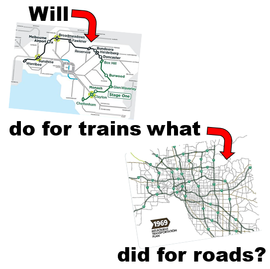
What if you threw an area's existing bus network away and designed a fresh one from scratch? Would it improve mobility or be more trouble than it's worth? And even if it turns out not to be practical can we at least apply lessons from the design exercise? 

Two years ago RMIT's Steve Pemberton developed a Melbourne-wide bus network based on the 'Squaresville concept' popularised by the late Dr Paul Mees. Instead of infrequent buses winding around back streets and converging on stations and shopping centres, routes would stick strictly to the main road grid such as exists in North American cities (eg Toronto from which Dr Mees got the idea) and here in Melbourne. 

Main grid routes would operate frequently so you wouldn't have to wait very long. And improved directness could make travel quicker. With a bit of walking either end Squaresville sought to replicate by public transport the anywhere to anywhere convenience of driving. Network maps could highlight the frequent routes (as they do in Toronto) to further sell the service. 

Rather than having planners trying to second-guess where people wanted to go with multiple infrequent routes converging on particular destinations, Squaresville would instead have a frequent grid reasonably walkable from most places. The trade-off for this was a likely longer walk to your nearest stop and having to change buses more, even for many shorter trips (*). 

I reviewed the RMIT work here. As a particularly pure version of a Squaresville network, I said it would have severe and probably fatal problems if implemented. It was even more radical than the dumped Adelaide network proposal. My alternative favoured reform rather than abolition of many existing routes and a 'modified grid Useful Network' approach that tolerated minor overlaps to serve major destinations from multiple directions.  

(*) Squaresville isn't the only response to an unwillingness to presume where people want to go. Another reaction, fashionable within parts of DoT, is to avoid planning fixed routes and stops by having flexible route buses summoned by an app. Whereas Squaresville routes scale up well with good speed, directness and economy per passenger, flexible route buses tend to be less productive opposites. Can or should we have a network with both? Keep reading!    


A 'world-leading clean slate' bus plan for Melbourne's west

Released earlier this week is another pure Squaresville-based bus network to chew over. Better Buses for Melbourne's West from Melbourne University promises a 'clean slate' for buses mostly west of the Maribyrnong. This includes the cities of Melton, Maribyrnong, Moonee Valley, Hobsons Bay, Brimbank and Wyndham. 

Wyndham and Brimbank progressively got reformed 'clean slate' networks in 2013-7, with the former following rail upgrades. With a 2-tier network including direct main routes on a mile grid, Wyndham's current network doesn't look much different from Toronto's except for some bending to feed our wider spaced stations. The critical difference is frequency with Toronto running its main routes every 10 minutes all day all week. As for other areas, Hobsons Bay and Maribyrnong have had little bus network reform for years. Melton recently gained some new routes. Moonee Valley got some minor reform with the 469

Reformed Wyndham and Brimbank networks sought to retain existing coverage goals (eg 90% within 400 metres of a bus) while putting savings from simpler routes towards more frequent service on main road routes. This enabled a two tier route structure of more frequent direct and less frequent neighbourhood routes. The introduction of some 7 day 20 minute off-peak frequency routes was a big step forward but service hours resources remained insufficient to boost most direct routes to run more than every 40 minutes off-peak (despite available buses as proved by widespread 20 min peak frequencies).  

The result was that despite many straighter routes connectivity to major centres remained limited. Melbourne University researchers John Stone and Iain Lawrie found that of the west's major centres only Footscray was accessible to large numbers of people within 30 minutes by public transport. A 2018 SNAMUTS map showed a similar pattern of inaccessibility in the west, especially away from Footscray and Sunshine. This contributed to a low mode share for buses in the west (even though usage on individual buses may be strong), high car dependence and concomitant expensive road expansions unlikely to ever relieve traffic congestion.  


2006's Meeting our Transport Challenges proposed 900km worth of more frequent SmartBus routes. Only half were delivered, mostly in the east. That left the fast-growing west with one completed SmartBus route versus ten in the east. The effect of the SmartBus orbitals and more frequent trains in the east is clear from the SNAMUTS map above. West-east inequality was also a theme of the Rail Futures Institute Metro 2 plan I reviewed last week


The power of frequency: Electric buses every 10 minutes

Better Buses for Melbourne's West would overturn this inequality at least with regards to on-road transport. Service levels will be high with just one service level on all routes. Frequent. More precisely every 10 minutes 7 days until 9pm dropping slightly to 12 minutes early morning and late at night. Not a single train or tram in Melbourne is as consistently good as that. 

The network shake-up will see the west's 80 bus routes become 25 longer and straighter routes. Like in the RMIT plan, routes 'stick to the grid' rather than converge on major centres like Werribee, Tarneit and Watergardens (Sydenham). There is no attempt to plan by anticipated usage with almost the same route density in the Laverton North industrial area as in residential and shopping areas. 

At 1500 to 2000 metres, route spacing is much wider in this network than others here or anywhere else (including Toronto). The paper says that "much of the region will be within a 750 to 1000 metre walk of stops" which many would be willing to walk if services were frequent. For 'mobility-impaired residents' there would be 'on-demand flexible route services' to provide fill-in coverage for mobility-impaired residents. 


Stated benefits include savings to household budgets (as car ownership would be less necessary), higher public transport usage, equity and access to opportunity and reduced emissions (especially if combined with a transition to electric buses). Local centres might get better connectivity from a wider area but at  at the cost of requiring a transfer for a lot of trips from surrounding areas that now just need one bus.   

Network Evaluation was based on comparing how many people could reach major centres within 30 minutes versus the current network. That 30 minutes is based on Marchetti's Constant and Plan Melbourne objectives. It was common for there to be a doubling in a centre's 30 minute catchment with Werribee Plaza enjoying a 400% increase (see supplied diagram below).

Outer car-oriented areas enjoyed the highest gains in accessibility, with that to Hoppers Crossing increasing by ten times. Centres like Footscray and Williamstown had the lowest gains but these were still significant, particularly at nights and weekends. 

The list of centres compared was from Plan Melbourne. These sorts of documents are written by white collar types who ignore the large workforce numbers in industrial areas like Laverton North or its need for any form of workforce transport access other than driving. Thus they omit it as a centre. However if Laverton North was included its accessibility would increase by maybe 30 fold given the number of frequent 'clean slate' routes crossing it compared to the sparseness of existing service. 

I highlighted the need (particularly) for a Tarneit - Laverton North connection in my Job Ready Network item. This network delivers not only that but in a form many times bigger. It remains to be seen whether the buses that will run through there every 12 minutes at midnight will get sufficient usage to justify their continuation! 

How much does Better Buses cost? $30 million more per year is quoted. That figure includes the flexible route bus network. There is also $25 million for 'simple intersection priority'. These figures are for the basic network. There's also an enhanced network option with a $5b works spend. More about this and the flexible route services later. 


Co-ordination with infrastructure

Melbourne often does infrastructure works without simultaneously reforming bus services. For example Southland Station got no reformed bus network when it opened (or since). Level crossing removals are  almost never accompanied by bus network reform even though level crossing delays might have been one reason for previous bus planners to have different routes on different sides of the track rather than faster and direct through routes. The level crossing got removed but the old bus network lives on.   


The Clean Slate network punches through this inertia by often specifying through routes, enhancing cross-rail connectivity at locations like St Albans and Ginifer. In this manner connectivity to destinations like Sunshine Hospital (east of Ginifer) from the west is improved. 

Something else that's special is the teaming up of buses and serious infrastructure in the 'enhanced network' version of this plan. This is something that cities like Brisbane do but Melbourne largely does not. At best buses might get some crumbs from road projects like North-East Link whose larger effect will be to induce driving. 

Better Buses rightly opens our minds as to what could be possible with bus priority and new bridges across creeks that (assuming they are kept bus only) would make some bus trips faster and more direct than car driving. Investment here would give the west connections that the east, with its more continuous road grid, has long taken for granted. Note though that there will almost certainly be political pressures from those who either don't want a bridge (especially between poorer and richer areas) or want it to carry cars too.  


The basic network, designed for fast and cheap roll-out within 18 months, doesn't have near this infrastructure spend with $25 million allowed for 'simple intersection priority'. However without the new bus roads and bridges from the Enhanced Network some of its proposed routes cannot operate in their proposed form. 

The authors really need to have presented a 'Stage-1' network map to show what parts of the network are possible now without these works. Even annotating the map with a black marker showing the current road gaps would have helped policy makers unfamiliar with the area. Also, because the coarser transfer-dependent network structure makes some local trips harder more should have been said about complementary walking and cycling improvements that could be an alternative for some.  

Gains and costs

Summarised below. Three network options are provided. These are the existing network, a basic 'clean slate' network and an enhanced 'clean slate' network. Both 'clean slate' networks have identical service levels and catchment populations. Enhanced spends more money on capital infrastructure to speed buses and (apparently) reduce bus service hours back to where they are now. 


The number of people within 800m of a frequent bus increases from 0 to nearly 700 000. This is achieved with about 25% more service hours under the basic option. Page 20 of the plan justifies this in terms of reversing the (i) decline in bus service km per capita (population grew faster than bus service km for much of the period after 2012) and (ii) historic underprovision of service in the western area. 

It is not clear how these service hours are allocated, more specifically what percentage goes to run the frequent main road network and what must be spent for the demand responsive component needed to retain coverage. Though to be fair assessing the latter is difficult as it is less scalable than fixed route public transport (which is easier to cost). My guess is that the flexible route component wouldn't be insignificant given the sparseness and, in places, limited permeability of the main road network. 

The increase in service hours is clawed back with the enhanced option. The secret is that the basic option is all about paring back routes and increasing frequency whereas the enhanced option adds bus priority to increase speeds (from 25 to 30 km/h) and thus bus service kilometres. That would entail spending more on fuel though electrification promises savings. 

Higher bus speeds would increase the number of people within 30 minutes of a centre and bus productivity due both to the faster service and more trips a bus can run per day. The enhanced option basically spends capital to reduce operational costs, making the network more efficient. This is not a small amount, with $5 billion quoted as an approximation. 

A faster and busier main network is likely to increase demand for the 'in between' flexible route services. Unlike fixed routes these do not economically scale up to increased usage. Hence more may need to be spent on them (unless they are reformed to become more efficient fixed routes). Also there is very likely to be political pressure for route changes which is likely to be in the direction of more overlaps and less economy. Thus I wouldn't be so confident about the reduction in annual bus hours spending projected, especially if increased speed promotes patronage on main routes and requires boosting service to relieve crowding (admittedly a good problem to have).   

How quickly can the 'clean slate' network happen? 

Better Buses claims that its plan to condense 80 existing bus routes into 25 more direct ones AND establish a complementary flexible route network could be implemented in the next term of state government. Page 21 gives a lead time of about 18 months (late 2022 to commencement in early 2024). This makes it way faster than multi-term road and rail projects. 

I won't say that's not possible. But there will have to be a transformation in the way things are done. And, no that can't mean the type of change where the Department of Transport spends six months or more looking inwards while it restructures. 

Current DoT processes take more than twice as long (37 months) to start just one new bus route. That 627 example is close to the simplest scenario with one route, about 30 new stops and no changes to the underlying network that it partly overlaps. 

A Clean Slate bus network transition is more complex with particular challenges in public acceptance and infrastructure. Even if it could be done in three and a bit years that brings us up to the next election which could make some pollies nervous if the network proves controversial (which, in its proposed form, definitely would). 

But we cannot and should not accept existing DoT time-lines if we want every suburb in Melbourne to get bus reform at least once before most of us die. Because the current rate of change won't even guarantee that. The survival of many route and timetable hangovers from 30 or 40 years ago is proof of that.  

Another case where change appeared daunting was of course the level crossing removal program. People thought it was impossible at the scale the government promised. But once there was the political will the money followed and it got done ahead of schedule by a dedicated authority. While LXRP processes were not perfect (eg in some aspects of public engagement) this project could provide a counter-example for naysayers who say that substantial bus network reform is too hard or we'd need to wait decades for it.  


What's the catch? 

There's lots to like about the Better Buses network, especially the turn-up-and-go frequency, simplicity and huge accessibility gains for some trips. And it's tempting to say that not only should we do this here but everywhere else. 

Before rushing headlong there's things that you should know first. The writers mentioned many. They humbly (and correctly) describe the network as a 'thought experiment'. Such experiments are useful to test the possibilities of network reform at its most extreme. The theoretical improvements set a benchmark against which to compare alternative more practical networks of the type you might wish to implement. 

Especially note the following:  

* We'll need more train stations - quick!

The indicative network map shows many routes finishing where they meet the rail line, especially on the Geelong and Werribee lines. The only problem is there's no stations at most. Building closer stations would slow the Geelong line, making it more like a suburban service. 

Not only would you need to build 7 new stations by 2024 but you'd also want some form of two tier service to add suburban capacity while preserving speed. In short some sort of Western Rail Plan

The Rail Futures Institute plan I reviewed last week proposes 2026 as a date for many of these new stations to be built by. If you take that as a 'best case', and note this is a private proposal and not funded government policy, you'll be having a new network operating without half its train stations. If you want a step change in public transport usage you need to deliver a good integrated service from Day 1 (like we did in 2015 when RRL opened), otherwise people will try it and never come back. 

A more pragmatic approach is far more likely. That is to keep the current network where several routes converge on existing stations and activity centres like Tarneit and consider changes when new stations open. 

* Coverage gaps cause big reliance on risky flexible routes

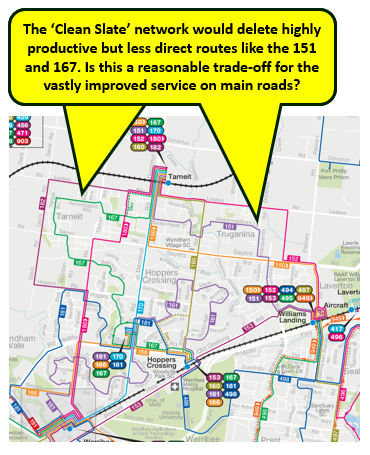
Better Buses reduces the number of bus routes from 80 to 25. Those that remain will be nothing like what operates now. Let's take an example from Wyndham, which along with Melton, is one of the west's fastest growing municipalities. 

The 2015 Wyndham bus network (and subsequent improvements) has been so successful that most routes on Wyndham's bus map are more productive than the average for buses in Melbourne. That applies almost equally for routes off or between the main roads. For instance Route 151 on weekdays is almost as productive as the main road route 150. And, if anything, being on smaller roads, 151 has better walking access from surrounding streets. 

As a trade-off for its more frequent main road network, the 'Clean Slate' network would make Route 151 passengers either walk to Sayers or Leakes Rd. Except for Tarneit on the Leakes Rd route neither would serve the key destinations locals would most want to go to. 


Figure 1 on Page 6 uses an out of date PTV map as the starting point for their network. It omits routes like 152 and 182 in the Tarneit area and 444 and 454 in the Melton / Cobblebank area. This didn't affect Tarneit much but it made their 'clean slate' network especially sparse around Melton. More people than expected will thus be beyond 1km from a bus route. In other cases they may be after a transport option that does not force a transfer. 

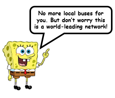
What's meant to fill the gaps for people who can't or won't walk the distances the 'clean slate' network demands? A lot of reliance is being placed on flexible route services. This raises many more questions than answers. 

First of all who can use it? That's an important question as existing buses can be used by anyone with a ticket for as many times they like. Page 21 says that the on-demand services would be for 'mobility impaired residents'. If that becomes a restriction then that disenfranchises the hundreds of thousands of people who don't count as mobility impaired. For these people we are taking away their local bus and giving nothing nearby in return. 
Having pointed that out, I will now be charitable and assume that the on-demand services will be truly inclusive, ie also open to people without impairments.  

There's other issues too. The operating hours of the on-demand service hasn't been specified. These are very limited with most of FlexiRides services we have recently rolled out. For instance the Rowville FlexiRide operates on weekdays only. And Rosebud's finishes very early in the afternoon. To be equivalent to the bus services removed any flexible route service should run 7 days until at least 9pm similar to the service that currently runs in Melton. 

Before we leave on-demand let's look at the word 'Affordable'. There's two dimensions here; affordability for the passenger and affordability for the taxpayer. To preserve the former along with fare integration there needs to be full integration with myki. We're not told that. This is a risk because other cities have implemented flexible route services that are not integrated with their main public transport fare system. 

As for the taxpayer, you want a network that delivers high patronage along with low cost per rider. That means a network that is overall productive. 

Some of the local bus routes this network rips out are very productive. An example is the previously mentioned Route 151 which enjoyed 54 boardings per hour in late 2018. Maybe this has fallen since the new Route 152 started nearby but usage likely remains higher than the Melbourne bus average of 20-something boardings per hour. 

Route 151 is just one productive local route that the 'clean slate' network seeks to replace with flexible services that are inherently low productivity. Low productivity means a high operating cost per passenger trip delivered. Put in another way this means that flexible routes do not scale up well.  

You might accept the small scale if you are looking to serve a small number of passengers with special needs. Or the demographics point to thin demand. Think of a flexible route bus serving Sydney's high-income northern beaches for example. 

If lots of people try to use on-demand services (very likely in a lower income, less car-owning catchment like parts of Melbourne's west) then speed and reliability drops off far faster than is the case with fixed routes. Melbourne monitors and reports on fixed route punctuality to provide a degree of public accountability. Our flexible routes, in contrast, don't have such reporting standards.

Flexible route operating costs spiral as more buses and drivers are needed to stop waiting times blowing out. Many flexible bus trials fail. In the few cases they they prove popular the best response to handle the loads is to convert them to a fixed route / fixed timetable service. High usage of existing fixed routes clearly demonstrate that areas like Wyndham and Brimbank can skip the bother and stick with fixed routes. 

Getting back to public finances, governments like the assured costs of contracted fixed route bus services. They're less enthusiastic about the variable budgets of flexible routes and microtransit. Canada's Innisfil has had to ration usage on its subsidised taxi scheme because people used it too often, something that no mass transit system should ever need to do. Other ways to limit usage include limiting service hours, accepting unreliably long wait times or requiring pre-booking. Another, and probably better option, is to just revert to having some fixed local routes inside the main road grids just as Toronto (and we) do now. 

The sparseness of UoM's 'Clean Slate' network risks imposing a high dependence on flexible routes. This is especially in suburbs with high bus using demographics away from main roads. Unnecessary use flexible routes magnifies reliability risks for passengers and financial risks for government. Add the political problems associated with scrapping existing high performing fixed routes and you have a showstopper on your hands.  


Some trips will be much worse than now

See the 'Clean Slate' network map (portion below) and imagine a short trip from Werribee to Manor Lakes. Right now that's easily done on the direct Route 190 up Ballan Rd. While not super-frequent it operates over long hours of the day including Sunday evenings. The 190 also serves Eagle Stadium, Werribee's main sporting complex. 


Even though Ballan Rd is a main road, the 'Clean Slate' network will have no bus along there.  Going off the map a Werribee - Manor Lakes trip will require a bus to bus transfer including having to cross  roads at a particularly hostile intersection (Tarneit / Heaths Rd). 

What if it was raining or very hot and you wanted to change at somewhere more 'civilised' eg a train station. A longer option involves a train to Tarneit West (if that ever gets built) and a bus to Werribee, traversing many more kilometres than today's direct bus. And Geelong trains are as infrequent as every 40 minutes on weekends meaning that even this short trip could take an hour. A similar issue applies in Melton where weekend gaps between trains are more like hourly. 

The conceptual network is based on 'no improvements to rail service frequencies' but it is acknowledged that these will be beneficial for the network with more efficient connections possible. This entails Metro and at least the Geelong line to Manor Lakes running every 10 minutes or better seven days. 

Even after train improvements you'll remain with a network that in exchange for making trips to destinations people commonly go to harder makes travel to places people rarely go to easier. Some will benefit from better cross-regional accessibility but a lot won't. Many passengers would prefer a reasonably direct single seat bus coming (say) every 20 minutes over catching two buses with 10 minute frequencies with inconvenient road crossings to change. Ballan Road's route already enjoys that level of service all day but it's possible to extend it to more routes by working the existing bus fleet harder. 

Considerations like these should determine the priorities for bus network upgrades for campaigns such as Sustainable Cities Better Buses for Melbourne's West (same name as the UoM paper) and other political advocacy as we may see in the lead-up to the state election. 

Usage will vary greatly between routes

The network map shows corridors not routes. It really needs to show routes to be a serious proposal. But I'm going to assume a 'strict Squaresville', ie every route is pretty much a straight line. This optimises access where destinations are evenly distributed and centres don't exist. It also maximises the frequency possible as there are almost no overlaps. 

In the 'real world' there are centres like Werribee Plaza and Woodgrove Melton. Some stations are busier than others. And transfer penalties do exist. 

Middle Toronto suburbs with east-west buses serving high-rises along the subway are a world away from industrial Laverton North through which the Clean Slate network seeks to run buses every 12 minutes until midnight. Less dramatically you have roads like Sayers Rd running east-west through Wyndham. That has lots of housing but the route's western terminus (currently no station) and eastern terminus (Aircraft Station with the route cutting through the RAAF base) are both extremely weak. This is in contrast to the existing networks in Wyndham and Brimbank were almost all routes have strong anchors at both ends (think Werribee, Tarneit, Sunshine, Watergardens etc).   

Even assuming the network operates as planned with lots of people willing to change buses some routes will be much busier than others. Thus there will be pressures to adjust service levels and/or extend routes that finish just short of a major centre to it. That could undermine the network effect that Squaresville relies on. You are better off applying a modicum of planning nouse and design useful routes that are not set up to fail. 


If you don't do this network atrophy can be a problem. A network might start off simple and frequent but later atrophy into complexity (historic examples here and here). The existing Wyndham and Point Cook networks have held up well with subsequent changes and additions improving it. 

But where two routes try to run a more frequent corridor, as is the case in parts of Brimbank (eg 400/427 or 426/456) then atrophy can set in as other considerations take priority over coordination and even frequencies. Brimbank's network clarity also suffered when the 422, overlapping other routes, was introduced. A better use for the resources would have been better frequency and operating hours on routes like 423, 424 or 425.

My guess is that the UoM suggested network won't necessarily be very robust since the demands for people to have their buses back will be overwhelming. Especially where the case to remove them didn't exist in the first place due to reasonable directness and good usage. Further work to refine the network  modelling could include the above map showing rough passenger numbers on each network segment (presented by colour). 

Big roadworks will be required

The basic clean slate network is about reformed routes and vastly better frequencies. The enhanced version speeds it up with bus priority. That requires major works and capital costs for the needed bus lanes etc. 

In case you're wondering, not all the roads on the network map exist. For instance there's currently no direct road connection from Altona Meadows to Sanctuary Lakes. Similarly Burnside lacks connections from Deer Park and Albanvale. Creeks, freeways, historic urban growth boundaries or council areas are all reasons for limited permeability. 

Building these links as bus/bike/pedestrian ways could be less objectionable to residents in local streets and make public and active transport faster than driving for some trips. But I would still expect political pressure, either against any link or wanting it for cars too.  

Evenso it would be wonderful if links like these could be built. They could give some large mobility gains. As an example the trip from Burnside to Sunshine Hospital would currently involve a bus and a train taking over 50 minutes. Completion of a bus road and a direct route would more than halve travel time to 20 minutes.  In some cases walks to schools could become easier too. 


The 'Clean Slate' approach delivers the biggest gains sooner by rolling out the basic network with an option for enhancements later. These can be staged if required. However even if the fastest bus speeds aren't achieved on Day 1, one thing is super critical. That is pedestrian access to and between buses. If that's not sorted out then the new network, so heavily reliant on transfers, will not work.  

Let's look at the Tarneit/Heaths Rd location we needed to change buses at to do the Manor Lakes - Werribee trip discussed before. That trip requires a change from the red route to the blue route. It's a walk of about 200 metres. This is because, unlike older tram stops in inner suburbs, bus stops are not at their most convenient and accessible point - right at intersections. This setback may be due to wider roads, inconveniently placed driveways and large turning radii loved by car throughput-loving traffic engineers. 


Note that the intersection has a roundabout instead of signals. Roundabouts give cars absolute right of way with continuous traffic flow preventing safe and reliable pedestrian access. This affects (i) access to direct routes like in the 'Clean Slate' network and (ii) connectivity between intersecting routes that the 'Clean Slate' network heavily relies on. 

Local walkability and bus access would improve if there was an LXRP style roundabout removal program to signalise large intersections. Signals would also need to be tied to appropriate bus priority. 


I would even go so far to say that even a basic 'Clean Slate' bus network cannot reasonably proceed without (i) all roundabouts on its routes (particularly at transfer points) being replaced with signals and (ii) easy and responsive pedestrian crossings at every stop (as people have already walked long enough without having to wait or divert further). 

While both are also beneficial for active transport and should be done, requiring them on Day 1 would affect the new network's roll-out speed. Unless money can be found in the roads budget the $25 million allocated won't be enough since it will barely fund three roundabout removals. I'd have liked more detail in Better Buses about this potentially significant constraint. 


Winning political acceptance

Better Buses correctly identifies this as a problem, even exceeding the ability to raise the $5 billion for capital works. The enhanced network option (in particular) relies on substantial road space reallocation to speed buses. About 10 years ago bus lanes were removed from Stud Rd in the east due to motorist opposition. The main bus using those lanes was the 901 SmartBus which runs every 15 minutes (even in peak). Thus the lane appeared empty most of the time. The Liberals removed the lanes. Labor hasn't brought them back. 

The one route per road philosophy of Squaresville along with services every 10 minutes invites similar issues in the west. Unless it's a separate busway cut off from cars buses will need to be seen to be operating at much closer intervals than 10 minutes, carry more passengers and (maybe) have electronic 'passengers on board' signs on the back to demonstrate the traffic relieving powers of buses and thus their value even to non-users.

Local walking and cycling improvements (which can also aid access to bus stops) may have a greater chance of success, especially if there is a bottom-up community engagement process and good active transport budgets. Along with less overtly noticeable bus priority measures at the main delay points. 

More could also be done to build new suburbs around fast bus and active transport only corridors operating through their centres. When people move house they make many changes in their lives including transport modes. Good suburb design backed up by service can make public and active transport use the natural choice for trips these are convenient for.  

Another dimension with public acceptance is the bus users themselves. Those who participate in surveys or attend in-person sessions may not necessarily be representative of riders. But they can make a lot of noise and potentially stop a network change. 

The new networks that were implemented in Wyndham and Brimbank survived a process that included public consultation. So (largely) did those in Auckland and Sydney. But Transdev's network greenfields, planned at the same time as Wyndham's but with inferior public engagement, did not. This network is vastly more radical than Auckland's  and may well suffer the same fate as Adelaide's

While the 10 minute network has benefits regarding connectivity across say a 5 to 20 km distance, it risks making a lot of shorter distance and more frequently made trips worse. Public saleability is likely to be worse in areas where the network is already half good. 

For instance Wyndham and Brimbank's networks are reasonably direct and lack the horrors of networks in other parts of Melbourne (eg no Sunday service, reduced summer timetables, confusing deviations, dead end termini, indirect loops, etc). There are still issues with coverage, limited operating hours and lower and desirable frequencies but these can largely be addressed by improving or extending the current network. 

It is quite reasonable for a person on a popular route that's being taken away to ask 'Why?' It won't be easy to give a good answer, especially if the replacement is an inherently cost inefficient flexible route bus.  

A more practical network alternative for testing?

We have been given details about three bus networks in Melbourne's west. The current, the basic 'clean slate' version and the faster enhanced 'clean slate' version. The last two have some big improvements compared to the status quo for certain types of medium distance trip that are currently mostly made by car. 

Major issues with the last two include the dependence on changing buses, the removal of popular routes and uncertainty over the cost of the demand responsive portion of the network (or even whether anyone will be able to use it). Even widespread 10  minute frequencies may not be a sufficient to win wide support.  

The UoM team made it hard for themselves because over half of the network they used (Brimbank and Wyndham) had their worst problems removed through recent network revamps. Other parts eg Maribyrnong have problems but also a lot of fairly frequent routes. If the researchers chose other areas, notably Mulgrave/ Springvale/ Dandenong, Hampton Park/ Narre Warren or Epping/ Reservoir/ Heidelberg/ Eltham they would have been able to find more justifications for reform as aspects of their networks are truly horrid. 

Notwithstanding the area choice made, it would have been interesting to have included an equivalent cost more practically-based middle-ground option as a comparison. That could include: (a) the acceptance of some route overlaps where this retains connectivity to major centres and stations and (b) the retention of midblock 'coverage routes' in place of the proposed flexible services. 

Extra route kilometres on the main network could mean that fewer routes operate every 10 minutes / 7 days. On the other hand savings could be got from (a) not running buses every 12 minutes at midnight through industrial areas and (b) avoiding high per-passenger cost flexible services. 

Funding like the suggested $30 million per year would deliver a lot of gains. Most of which would be frequency and operating hours increases on existing main road routes (including boosts to every 10 or 20 minutes). Being largely timetable changes (at least in already reformed areas like Brimbank and Wyndham) implementation will be fast and uncontroversial.  

This option would be vastly less disruptive and more saleable than the pure Squaresville options tested. However its theoretical network benefits may be less. How much less and what would be the opportunity costs? This is something that research including this as an option could have established. Such a review of a practical option would have added real-world value to the research for a wider audience including state government, local councils and community advocates.  

Conclusion

Melbourne University has produced a 'thought experiment' grid bus network for Melbourne's west. It shows that, subject to trade-offs in coverage and transfers, a reformed bus network can multiply peoples' access to jobs, education and opportunities. Its 25 streamlined routes puts nearly 700 000 people within 800 metres of day and night frequent public transport. So many Melburnians haven't had that level of service since tram timetables got cut in the early 1950s.  

The enhanced option proposes something we too rarely do with buses in Melbourne; that is regard them as faster high order transport with their own priority, exclusive bridges and serious capital investment. The $5 billion suggested is less than a major road or rail project but would deliver accessibility benefits over a wider area. While the comparison isn't drawn, this enhanced network could be as significant for the west as the Suburban Rail Loop will be for the east.  

With such huge benefits, can I recommend this precise network? 

No! 

Could it inspire the development of more suitable bus networks? 

Yes! 

As a rigidly applied Squaresville, this network creates too many have nots living between often poorly permeable mile blocks. Changing, that this network forces even for local trips, will be a miserable experience waiting for gaps between cars at treacherous roundabouts and walking along back fences to stops. Riders will lose their local bus despite it being well-used while numerous routes will traverse industrial areas every 12 minutes at midnight. And users must toss up between longer walks or chancing it with indirect, uncosted and possibly limited hours flexible buses. The political and financial uncertainty of this network form such a counterweight to its promises that could prove its undoing. 

What could be a better alternative if you had (say) $30 million per year for improved bus services in an area like Melbourne's west? Especially if you were approaching an election and didn't want to be too controversial? 

For western areas, like Brimbank and Wyndham, with recently reformed good performing networks serving favourable catchment demographics, you're best off throwing more buses on existing routes that already form an effective grid. Instead of running every 20 or 40 minutes the grid routes would be every 10 or 20 minutes with longer hours. Potentially 24 hours on weekends in some cases. 

Top performing  bus routes worth upgrading are listed here (with many in Melbourne's west).  And for more background on Wyndham see here. Local roadworks would also progressively improve pedestrian access and connections to and between stops on main roads to encourage usage. Add bus electrification, train frequency upgrades and cycling infrastructure for a broader cost of living and sustainability narrative. 

Other areas really do need bus network reform of the type Brimbank and Wyndham have had. Before an election I wouldn't get too much stuck in to the detail. I'd certainly not be publishing maps showing lots of popular bus routes vanishing. Key needs in areas like Greater Dandenong include longer operating hours and weekend service, even if these are added to existing popular routes now pending a wider reform to simplify the network later. A (non-exhaustive) list of routes that could do with Sunday service is here. Again a wider view would be beneficial, eg a plan to deliver 7 day service on all metropolitan residential area bus routes. The cost of upgrading the most needed routes wouldn't be high - somewhere in the low millions per year. There are even cases where 10 minute service could be economically rolled out with minor reforms involving a few routes only

The end point of these approaches would be the same - a simplified network with more direct routes, better frequencies and  longer operating hours. But, unlike the UoM's version of Squaresville a 'modified grid' approach would have fewer transfer penalties and wouldn't be taking an axe to coverage. This makes it much more like the actual network in Toronto that Dr Mees got his Squaresville inspiration from. Implemented networks in Auckland, Sydney, Perth and Brampton (outside Toronto) are other working network reform templates. 

Buses can be fast, frequent and direct but are too rarely thought of and delivered as such in Melbourne. Dr John Stone and PhD candidate Ian Lawrie have helped shift the discussion agenda for bus services in this helpful direction.  That's a valuable service given the untapped opportunities, relative affordability yet past recent political wariness when it comes to bus service reform in Melbourne. 

The time for ambivalence is over with Better Buses for Melbourne's West telling us in no uncertain terms the benefits of acting now on buses.  

Learn & do


Join Friends of the Earth Better Buses for Melbourne's West campaign 

Comments are appreciated and can be left below.