One of the parts of Melbourne with the most number of routes but the least service on most of them is the narrow bayside strip from St Kilda to Sandringham via Elwood and Brighton.
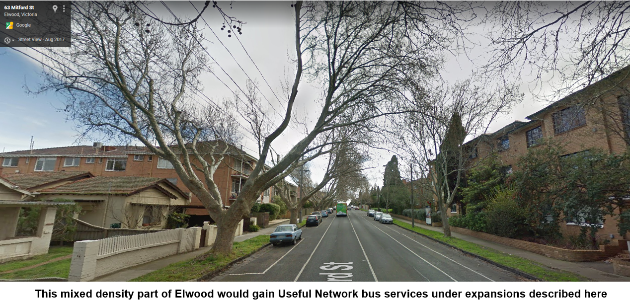
The area is a real demographic mix. It includes nightlife in St Kilda, young working renters in Elwood apartments, multi-millionaires in Brighton and comfortable retirees in Sandringham. Trams serve its northern portion while the southern part is near the Sandringham train line. There used to be Victorian Railways trams in the southern part as well. These were closed down after WWII. However their legacy lives on through the long operating hours of some bus routes in the area.
The area is a real demographic mix. It includes nightlife in St Kilda, young working renters in Elwood apartments, multi-millionaires in Brighton and comfortable retirees in Sandringham. Trams serve its northern portion while the southern part is near the Sandringham train line. There used to be Victorian Railways trams in the southern part as well. These were closed down after WWII. However their legacy lives on through the long operating hours of some bus routes in the area.
The area's increasing population density and young urban demographic (who may be more open to using public transport for a variety of trips) provide opportunities for increased patronage from a better bus network. And, as we'll discuss later, duplication of and (arguably) overservicing on some routes should make the costs of reform low.

Existing Useful Network
I explain the Useful Network concept here. It's those routes that are frequent enough and run over long enough hours to be useful for many trips. I've specified a 20 minute frequency on weekdays and 7 day service until 9pm. In other words the coloured lines on the Melbourne Public Transport Frequent Network map with the 20 minute frequency selected.
The maps below show the existing Useful Network. It's dominated by the Sandringham train line. The northern portion also has trams.
North-south Useful Network buses include 216/219 and 220 around St Kilda East, 605 around Caulfield South, 246 around Elwood and the multi-route 600/922/923 combination south of Sandringham. West-east Useful Network routes include 630 from Elwood, 703 from Brighton and 828 from Hampton. The left map shows St Kilda - Brighton while on the right is Brighton - Sandringham (click for better view).

East-west Useful Network gaps exist near Dendy St, South Rd and Bay Rd. Reform here involves changes to out of area routes such as 811, 812, 822 and possibly 828. Changing these would affect a lot of other areas so I'll concentrate on the north-south routes today.
Notice all the loose ends in the Brighton area? This is because useful corridors often finish just short of shops and railway stations. Network complexity also means that some corridors (eg St Kilda - Elwood) have multiple routes but with insufficient frequency for each to be useful. See map below.

The southern termini for routes 216, 219, 220 and 605 owe more to history than being useful destinations. Routes 600, 922 and 923 are very similar but split and recombine multiple times. Not all parts of these routes operate all day, with limited span, low frequencies and multi-hour gaps common. 922 and 923's numbering do not convey their similarity to Route 600, despite being 80% identical and knowledge of all required to successfully use them. Overall today's network is more complex than in the 1990s but gives less service.
Service hours are also worth mentioning. It's a case of haves and have nots. Routes 246, 216/219, 220, and (to a lesser extent 600) have early starts and late finishes reflecting their heritage as ex-Met services (and before that Tramways Board). The worth of some is debatable since some of these routes run near the Sandringham train line. In contrast operating hours are consistently shorter (9pm or earlier finish) on east-west routes such as 703 and 828 despite their unique coverage away from trains and trams. Other routes with early finishes, such as 606, 922 and 923, just make the network unnecessarily complex.
Expanded Useful Network
An expanded Useful Network is below. Highlights include new Useful Network routes via Hampton St (new 604) and Elwood (upgraded 606). Some routes are extended to more active termini like Elsternwick and North Brighton. The overall network is simpler than what runs now, with two fewer routes.

See the link to Useful Network map if you need more detail. You can also view it below after locating the area and selecting the menu (top left) to show whether you want to see existing or expanded Useful Networks. Top right opens it in another window if preferred.
Most or all of the resources for this network come from removing route overlaps and duplication. Routes removed include the confusing and poorly used 600/922/923 and 216. These are largely replaced by upgrades to routes like 606 and the new neighbourhood route 603.
Some resources are also freed by running some poorly used routes less frequently for less of the day. The areas that would lose are generally either close to the train or are areas with demographics unsuited to high all-day public transport usage eg Brighton. The table below (click for a better view) indicates potential resource shifts between routes.

While precise accounting has not been done, scope exists to scale down the proposed network if required. For instance the extensions of Route 220 and 605 to Brighton North are not necessary to achieve the gains in Elwood and Hampton St.
An expanded Useful Network is below. Highlights include new Useful Network routes via Hampton St (new 604) and Elwood (upgraded 606). Some routes are extended to more active termini like Elsternwick and North Brighton. The overall network is simpler than what runs now, with two fewer routes.
See the link to Useful Network map if you need more detail. You can also view it below after locating the area and selecting the menu (top left) to show whether you want to see existing or expanded Useful Networks. Top right opens it in another window if preferred.
Some resources are also freed by running some poorly used routes less frequently for less of the day. The areas that would lose are generally either close to the train or are areas with demographics unsuited to high all-day public transport usage eg Brighton. The table below (click for a better view) indicates potential resource shifts between routes.
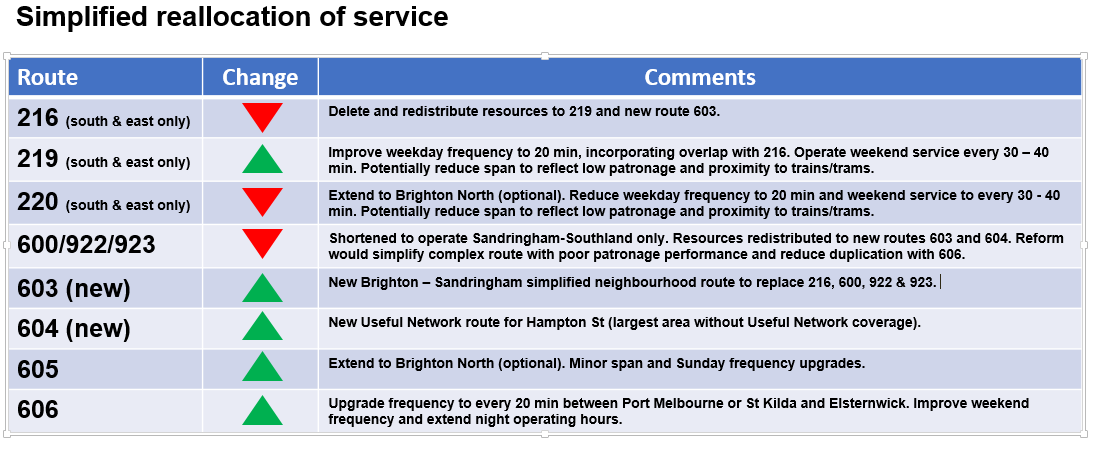
While precise accounting has not been done, scope exists to scale down the proposed network if required. For instance the extensions of Route 220 and 605 to Brighton North are not necessary to achieve the gains in Elwood and Hampton St.
Service priorities for expanded St Kilda, Brighton and Sandringham Useful Network
1. Terminate Route 600/922/923 to operate Sandringham - Southland only. Upgrade Route 606 operating hours and frequency to provide simpler and more regular services in the Elwood area. Make associated changes including (i) new local route 603 (to retain coverage between Brighton and Sandringham), (ii) extension of Route 630 to Elsternwick and (iii) amalgamation of Routes 216 and 219 into an upgraded 219 with minor route changes in Brighton area.
2. Introduce a new Useful Network route between Elsternwick and Sandringham along Hampton St (Rt 604). This brings better service to a large area lacking a strong north-south route. Some resources for this could be obtained by reducing frequency and/or span on poorly performing routes such as 216/219 and 220 in areas that are near alternative services.
3. Extend Routes 220 and 605 to a stronger southern terminus such as North Brighton.
4. Make minor upgrades to Route 605's operating hours and Sunday frequency.
Conclusion
The St Kilda, Brighton and Sandringham area has a lot of bus routes but often poor usage on them. However there exist growth opportunities in areas with dense housing or corridors unserved by bus.
Unlike areas where there is no 'fat' to prune, the cost of pursuing growth here is less because of the potential to simplify the network and reallocate bus hours to where they could be better used.
What do you think? Do you have other ideas? Are there things you see are wrong with the above? Please let us know your thoughts in the comments below.
PS: An index to all Useful Networks is here.
PS: An index to all Useful Networks is here.
4 comments:
Another excellent item Peter!
Yes; there's certainly history associated with the bus routes and a "clean sweep" is probably more than overdue.
The Sandringham to Southland mish mash (600/922/923) seems sufficiently well used to justify current service levels. Beterrn Sandringham and Beaumaris the service follows the route of the VR electric street railway (1919-1956 to Black Rock and 1926-1931 to Beaumaris). After the trams closed, it was a VR Road Motor Service that later became the original route 901.
There was a service (operated by Nuline) from North Brighton to Hampton along Hampton Street.
The Middle Brighton to Brighton Beach of the former St Kilda electric street railway was never replaced after the trams went in 1957. The replacement bus service only ever operated to Middle Brighton Beach. It was later cut back to Bay Street and diverted as mentioned in the article.
To add to the picture, there was the "Melbourne Brighton" route 2 to the city that competed with MMTB trams much of the way. It's now part of the truncated route 216.
The services are generally "shadows of their former selves" and ripe for reorganisation along the the lines suggested by Peter.
I live near St Kilda station, and sometimes have to go to different bits of Brighton on weekends, and the PTV app told me that the bus would far faster than the tram and then train, and it is ! One trip i was the only one that went from beginning to end in middle Brighton, and one of only 2 passengers for much of it. Assuming its going at about the right time. So very useful. It was only recently that i actually looked up the route maps to discover that the 600, 922 and 923 were almost the same ! They should just be the same. And run more often, and like all buses be integrated with other transport with either their own app, or integrated with the tram tracker. But i see that youre deleting them altogether ! Id have to rely on tram and train which takes 45 mins where the bus takes 20. O i see you say the 606 would replace them but youve drawn it going to elsternwick station instead of sandringham. I think theres a place for a bus that just poes down the beach road, lots of peeps go to the beach, or to places just inland.
Another great analysis Peter. Was waiting for this one as i grew up on the Rt 220/605. You mentioned the southern terminus for these routes at North Road are there for historical reasons. Do you know the reason/s?
I always thought these routes should have continued to Gardenvale Station to terminate there, although this would mean a triplication of services between Kooyong Road and Gardenvale station (RT 220/605/630). I think your suggestion of extending them to North Brighton station is better, as the Bay Street area is undergoing redevelopment.
Adam - not sure. Although the terminus was fairly close to the Zone 1/2 boundary. Just guessing, but maybe there was a wish to avoid routes with zone overlaps (though it was a mess before myki as different routes along the same road had different zone rules). And tere might have been past rules about private and government routes not duplicating from the days when poaching passengers was significant (when buses ran at a profit).
Post a Comment