
However there are places such as the City of Greater Dandenong where buses are very underserviced despite a population keen to use them. Such areas might have disproportionately missed out on the 2006 - 2010 round of bus service upgrades. Or they might have population increases and other demographic shifts that result in full buses even if they come only every 40 minutes.
People in Brighton or Eltham might be unexcited about using buses every 15 or 20 minutes but those in Tarneit, Point Cook or Springvale will crowd one that's half that frequency. These are the sorts of areas where you can buy five or ten buses, put them on existing (but preferably reformed or extended) routes and be confident they will be well used.
Over two-thirds of Melbourne's bus network reflects history more than current need or the results of recent planning. Routes can run underused for decades, with no pressure to make them more viable or redistribute service to where it may be more needed. Overcrowding can be ignored, and comprehensive network reviews are rare.
Unlike as attempted and required for US cities, there is also no distributive justice for bus services in Melbourne. This is even though, unlike infrastructure-dependent train and tram services, routes and timetables can be changed with little more than the stroke of a pen.
It's not even all a ridership versus coverage trade-off that Jarrett Walker talks about; historic maldistribution of service and overlapping routes mean parts of Melbourne exist where we should be able to achieve gains in both without having to choose either/or.
Craigieburn has all the demographic signs that it is is one these high patronage potential areas. It's been growing fast for about 20 years. It is off-centre to the train line, with the new town centre and dense new subdivisions increasingly distant from the station. Although that by itself doesn't guarantee high patronage potential.
However Craigieburn does have packed-in family households on small blocks of land. Charting Transport maps show population density (especially parts of Craigieburn West) far higher than what we're used to with an outer suburb. In fact it is more like that of an inner suburb like Brunswick West. Not only that but while car numbers have exploded (due to growth) its car car ownership rate per adult has actually declined!
High population density, adults without cars and a young largely migrant-derived population in or seeking education and employment mostly outside their suburb. Where are they? On the buses!
Despite limited service there is heavy usage of the buses that do run . That's especially for Route 529 and to a slightly lesser extent Route 533. They're short routes so their patronage in absolute terms is nothing special. But when you look at the number of people who on average are waiting at each bus stop or on the bus there is high demand.

Today I will not look too hard at overlapping and duplicating routes. That's because, unlike some established areas, not many exist (network map below). The key issues are lack of coverage, lack of frequency and limited operating hours, especially given modern travel and working patterns.
All of Craigieburn is in the seat of Yuroke, held by Ros Spence MP.

Outer suburbs aren't what they used to be
Before getting onto Craigieburn, we'll talk about outer suburbs more generally. Particularly those in Melbourne's north and west.
The typical metropolitan outer suburb has changed greatly over the last 30 or 40 years. Blocks have shrunk. Houses are bigger (although some developments have townhouses and even apartments). Many are favoured by migrants, who in the 1960s and 70s would have settled in inner areas (unless they were English, who populated outer, particularly coastal, suburbs). Our foreign investment laws, which encourage overseas buyers to add to our housing stock by building new, may also be a factor. Especially if associated with migration later.
Drivers of high population density in new subdivisions include high land prices, developers wishing to maximise yield, a price-sensitive market that wants the biggest house it can afford and more working couples that don't want a large high-maintenance backyard.
Despite common wisdom that 'everyone needs a car to live in these parts' some of these areas, particularly those north and west of Melbourne, have lower than expected car ownership and well used bus routes. See the previous links for more discussion on this.
Degentrification
We hear a lot about 'hipsters' and gentrification in inner suburbs. We don't hear as much about degentrification of outer suburbs. However the latter is quite common. You can see it visually in years since 1986 on this Charting Transport SEIFA animation . The changing fortunes of inner versus outer areas are quite evident.
While not always the case, many suburban estates are sold to homebuyers purchasing with a mortgage. A loan may require two earners on (say) $40 000 to $80 000 each. While these incomes are modest for some readers here, these and other attributes are enough to make an area rank middle to high on socio-economic status ranking systems like SIEFA.
Things change as a new estate ages. Original owners may have upgraded or moved on. Investors will have bought some homes for use as rentals. Tenants (on average) have lower incomes than owners, particularly in outer areas as high income tenants (especially without children) will prefer the lifestyle benefits of inner suburbs (whose low rental yields make renting much cheaper than buying).
Even if people stay put their incomes may have fallen if one partner leaves or reduces paid work to have children. Relationships may split. Older (retired) parents may move to be nearer their adult children and grandchildren. Nearby employment areas like Broadmeadows may deindustrialise and lose good paying jobs. These all affect an area's SEIFA (an index based on multiple factors, most notably employment, income and formal education).
New estates may have poorer capital gain performance than established suburbs. This is particularly likely where block sizes are small and more of the original value is in the building (which depreciates). As people often like to buy in the 'best' area they can afford, reduced growth is likely to make fringe areas the only option for lower income buyers (since closer-in areas have appreciated beyond their reach).
These are just some of the reasons for degentrification to happen as new estates age. Its extent varies. Some estates don't degentrify much while others can go from top to bottom in 30 years. Parts of Roxburgh Park and Craigieburn exemplify the latter.
Effect on transit usage
Degentrification, where it affects education and workforce participation, may reduce trip activity from the home during peak times. Would this affect public transport usage? It depends.
Low SEIFA areas typically contribute few CBD workers. On average these people earn good incomes and are more likely to take public transport (notably train) to work. Such commutes may also involve a feeder bus leg. Fewer high income workers might be expected to reduce commuting.
Local jobs may not necessarily be in places or at times where convenient public transport operates, and parking may be 'free' anyway. That might depress public transport use. On the other hand lower SEIFA areas with more cost-conscious households may have more of them where not every adult owns a car. This benefits public transport usage throughout the day.
We are seeing a new generation of new, big, dense, young working migrant family suburbs like Tarneit and Truganina where bus routes are performing well during both peak and off-peak times. Weekend patronage is also healthy. Buses in parts of demographically similar suburbs like Craigieburn are doing the same.
With few exceptions the service response from governments have been the same old 'bus every 40 minutes five to ten years after development'. That may have reflected past lower densities but doesn't match today's housing densities and working patterns. There is quite possibly a case for buses in newer dense suburbs to run every 20 minutes throughout the day, especially if their street patterns are supportive (which they are compared to 1980s 'spaghetti suburbs') and routes can be more direct and more widely spaced but retain good walking accessibility.
Some of these 5 to 7 day/20 minute frequency routes and corridors do now exist. Usage varies, especially on weekends. Some around Cranbourne don't seem to do that well, possibly because they mostly only have one major destination. Those around south Morang also have quiet patches, possibly because they are two-route corridors (eg 386/387) and PTV is quite poor at explaining and selling the higher combined frequency. However those in Werribee and Tarneit (which are demographically more similar to Craigieburn than the other places mentioned) get good patronage throughout the week.
I explain the Useful Network concept here. It's those routes that are frequent enough and run over long enough hours to be useful for many trips. I've specified a 20 minute frequency on weekdays and 7 day service until 9pm. In other words the coloured lines on the Melbourne Public Transport Frequent Network map with the 20 minute frequency selected. This map shows the sparsity of Useful Network routes in most fringe areas, despite their sometimes high population densities.

Existing Useful Network
That was a long preamble. What Useful Network routes exist now in Craigieburn? Not many.
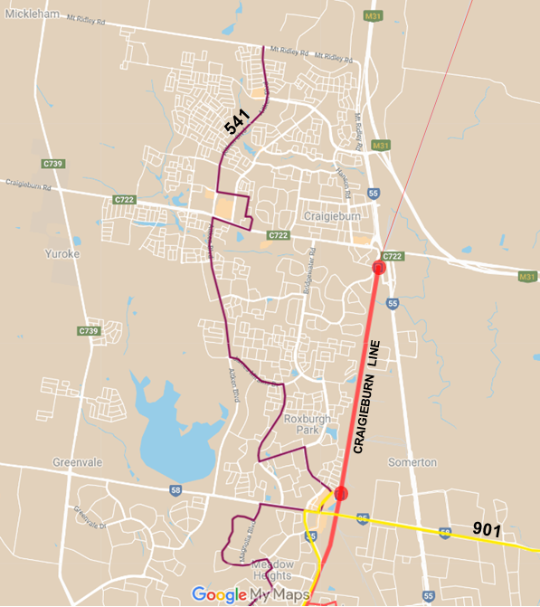
Skirting the suburbs's east is the Craigieburn train line. Paralleling it, but serving the town centre and more central to development is the 541 to Broadmeadows. Its extension to Craigieburn North was fairly recent. The only other Useful Network bus in the area is the 901 orbital via Roxburgh Park.
There are no Useful Network bus connections from the station. Instead routes operate either every 30 minutes (ie not harmonised with trains every 20 min) or every 40 minutes (less frequent but harmonised with trains). Use is understood to be particularly high on Routes 529 and 533. Both operate every 40 minutes with the 529 running every 15 minutes during the morning peak.
Expanded Useful Network
If you wanted to quickly boost service on the busiest routes you would just increase 529 and 533's interpeak frequency from every 40 to every 20 minutes. Ideally this boost would apply on weekends as well. Longer operating hours would also be desirable given the area's population density and distance from trains. No more buses should be needed as both routes already run every 20 minutes or better during peak periods.
A better approach is to review bus routes given coverage gaps. The existing Route 529 could be bulged west to unserved areas but this makes it less direct for some trips if you were to keep its existing terminus at Highlands Shopping Centre. Reduced directness would make some existing trips slower, including some from densely populated areas.
This is particularly topical for Craigieburn because (apart from density) it is everything that good transit-oriented planning isn't. For example the new town centre was built remote from the station, leaving the existing smaller shopping centre near the station to struggle. That centre's decline means that people will need to choose between being walking distance to a station or walking distance to a good shopping centre, instead of having both. Without a low car housing option in Craigieburn (which even Roxburgh Park has near the station), households will buy more cars, drive them further and use active and public transport less.
Much like outer Adelaide where train stations tend to be at the back of everything, population density in Craigieburn rises the further away you get from the station (particularly westwards). And, as you can see from the picture below, there are settled small-block subdivisions with no bus service at all.

The solution to poor coverage is to add and/or lengthen routes. This improves directness and journey speed as each route doesn't have to go to as many places for the network to have reasonable coverage. You can see this in the Point Cook example below, where Routes 494 and 495 are about as direct as the road network allows. Both routes are well used, particularly 495.

As well as improved coverage to the west, a case exists for an eastern connection to Epping (eg by extending 357 to Craigieburn) and possibly a south-western connection to Mickleham Rd (eg by extending 543 to Craigieburn). While these would allow easier access than exists now, development is not yet continuous. As you'll see on the map later, I have these extensions as thin (less frequent) lines rather than thick Useful Network routes. However that might change with future development if Craigieburn gets something like a SmartBus orbital.
Major roads to the west are now long enough to justify direct services rather than current routes that loop inwards or dead end before development finishes. Also worth noting is Labor's pre-election promise of a Craigieburn - Wollert - Mernda bus route last year.
Below is a potential expanded Useful Network (thick lines). Local routes are shown in thin lines for context as some are extended or rerouted.

View it with caution. It's a growing area and some alignments would likely change. Maybe there are too many Useful Network routes. Although if population density is twice as high, it is not unreasonable that buses run twice as frequently (or better). And the area's existing route (the 529) is very well used. So I throw a lot of service at Craigieburn West. I'll discuss each route in order of priority so upgrades can be phased in over time.
Route 529
This is top priority. It is already very busy. I try to kept it fairly similar to now. However I have extended it west via Brookfield Bvd (subject to the road existing) and broken its connection with 533. That was a cost of the increased coverage, which as you saw from the large unserved area before, is very necessary. It serves a dense area. So I suggest a 10 - 15 min peak frequency, 20 minute interpeak service (including weekends) and a 30 minute night service to match. Longer operating hours are desirable since the area is so far from trains.
Route 533/535 pair
Route 533 is an existing route. Route 535 is an added route. Ideally it would be numbered 532 or 534 but these numbers are taken. 533 and 535 would form a through-routed pair similar to the successful 494 and 495 in Point Cook. In other words all Route 533 trips, on arriving at the terminus, would continue as Route 535. And vice versa.
Where one of those routes serves a major shopping centre (as 535 would) this through-routing would give passengers on the 533 one-seat trips to and from it by riding through the terminus. Also those on Highland Dr have the option of catching either 533 or 535 from the station, effectively doubling the service frequency available.
Routing through termini is a good approach in fringe areas like Point Cook South and Craigieburn West where there is no logical end point such as a railway station or shopping centre. Because it produces two L or U-shaped routes this is more direct than confusing loop routes, which may sometimes have numbers in each direction (like 681 and 682) or single numbers (like 443 or the horrid and unforgivably new 380).
The 533/535 round trip is just over 15km. Because local buses travel at about 22 - 25 km/h, it should be able to complete it in just under 40 minutes, particularly during off-peak times. This route length is efficient for the 533's current 40 minute frequency, which meshes with every second train at Craigieburn. If you were going for a 40 minute frequency you would offset trip departures by 20 minutes at the station to provide a higher frequency for those in the west who could use either route (also done at Williams Landing for 494/495). However, because of population density, I've suggested the pair run at a 20 minute Useful Network frequency, at least on weekdays.
Route 544
This currently runs every 30 minutes between Roxburgh Park Station and Craigieburn Station. One of Roxburgh Park's first routes, it commenced before the Craigieburn Town Centre was built. Because it already connects to a train at Roxburgh Park and the northern part of the route is near the newer Route 528 to Craigieburn Station, I have suggested operating it to the town centre at Craigieburn instead of the station.
Then there's the 30 minute frequency, which doesn't harmonise with trains. This means the same pattern of connections repeats only every hour. And if you are trying to connect with a bus every 40 minutes, the repetition is every 2 hours. One could drop its off-peak frequency to 40 minutes. Or raise it to 20 minutes to make it a Useful Network route, at least on weekdays. I've opted for the latter but it is a lower priority than the others. My thinking is that Roxburgh Park and Craigieburn stations are nearly 4km apart and the 544 provides significant unique coverage distant from the 541.
A potential option, desirable of further study, is to extend Route 544 to the south-east to better serve jobs in the Somerton Park Industrial Estate. Together with its rerouting to Craigieburn Town centre this would improve access to jobs for Craigieburn West residents who would gain a same-stop connection from the new route 535.
Other routes
Craigieburn currently has no east-west circumferential routes outside its local area. And there is no direct bus from Greenvale to the Craigieburn Town Centre. Extensions to local routes 357 and 543 are drawn to cover these off.
The map shortens Route 537 due to the extension of other routes (535 and 543) in its area. And alters its off-peak frequency to 40 minutes to mesh with trains. Similar is suggested for Route 528. While this is a frequency drop, many areas will gain from the new 535 and upgraded 529.
For more information click on the interactive map. You can switch on and off existing and expanded Useful Network layers.
Service upgrade summary for Craigieburn (most important first)
1. Extend existing Route 529 to improve coverage. Upgrade to operate every 20 minutes off-peak, with longer operating hours and a better peak service to reflect its current high usage.
2. Create a new route pair comprising Route 533 and new route 535, with trips operating through the terminus. At least every 40 minutes but preferably every 20 minutes.
3. Reroute 544 to serve Craigieburn Town Centre and potentially upgrade to every 20 minutes to make it a Useful Network route coordinated with trains at Roxburgh Park.
4. Various extensions and rescheduling of local routes (involving 357, 528, 537 & 543) to enable east-west travel and connections with trains.
Conclusion
A more useful bus network for Craigieburn has been presented. With few efficiency offsets, it will cost more buses, more drivers and more money. However population growth have far outstripped service growth.
And, as demonstrated by high patronage on local routes such as the 529, the area has the demographics and potential for further patronage growth. This is a work in progress and further improved service on more of corridors only partially upgraded (eg Craigieburn Rd) will be needed as the area grows.
What do you think? Is it too much? Or too little? Please leave your comments and ideas below.
PS: An index to all Useful Networks is here.
Before getting onto Craigieburn, we'll talk about outer suburbs more generally. Particularly those in Melbourne's north and west.
The typical metropolitan outer suburb has changed greatly over the last 30 or 40 years. Blocks have shrunk. Houses are bigger (although some developments have townhouses and even apartments). Many are favoured by migrants, who in the 1960s and 70s would have settled in inner areas (unless they were English, who populated outer, particularly coastal, suburbs). Our foreign investment laws, which encourage overseas buyers to add to our housing stock by building new, may also be a factor. Especially if associated with migration later.
Drivers of high population density in new subdivisions include high land prices, developers wishing to maximise yield, a price-sensitive market that wants the biggest house it can afford and more working couples that don't want a large high-maintenance backyard.
Despite common wisdom that 'everyone needs a car to live in these parts' some of these areas, particularly those north and west of Melbourne, have lower than expected car ownership and well used bus routes. See the previous links for more discussion on this.
Degentrification
We hear a lot about 'hipsters' and gentrification in inner suburbs. We don't hear as much about degentrification of outer suburbs. However the latter is quite common. You can see it visually in years since 1986 on this Charting Transport SEIFA animation . The changing fortunes of inner versus outer areas are quite evident.
While not always the case, many suburban estates are sold to homebuyers purchasing with a mortgage. A loan may require two earners on (say) $40 000 to $80 000 each. While these incomes are modest for some readers here, these and other attributes are enough to make an area rank middle to high on socio-economic status ranking systems like SIEFA.
Things change as a new estate ages. Original owners may have upgraded or moved on. Investors will have bought some homes for use as rentals. Tenants (on average) have lower incomes than owners, particularly in outer areas as high income tenants (especially without children) will prefer the lifestyle benefits of inner suburbs (whose low rental yields make renting much cheaper than buying).
Even if people stay put their incomes may have fallen if one partner leaves or reduces paid work to have children. Relationships may split. Older (retired) parents may move to be nearer their adult children and grandchildren. Nearby employment areas like Broadmeadows may deindustrialise and lose good paying jobs. These all affect an area's SEIFA (an index based on multiple factors, most notably employment, income and formal education).
New estates may have poorer capital gain performance than established suburbs. This is particularly likely where block sizes are small and more of the original value is in the building (which depreciates). As people often like to buy in the 'best' area they can afford, reduced growth is likely to make fringe areas the only option for lower income buyers (since closer-in areas have appreciated beyond their reach).
These are just some of the reasons for degentrification to happen as new estates age. Its extent varies. Some estates don't degentrify much while others can go from top to bottom in 30 years. Parts of Roxburgh Park and Craigieburn exemplify the latter.
Effect on transit usage
Degentrification, where it affects education and workforce participation, may reduce trip activity from the home during peak times. Would this affect public transport usage? It depends.
Low SEIFA areas typically contribute few CBD workers. On average these people earn good incomes and are more likely to take public transport (notably train) to work. Such commutes may also involve a feeder bus leg. Fewer high income workers might be expected to reduce commuting.
Local jobs may not necessarily be in places or at times where convenient public transport operates, and parking may be 'free' anyway. That might depress public transport use. On the other hand lower SEIFA areas with more cost-conscious households may have more of them where not every adult owns a car. This benefits public transport usage throughout the day.
We are seeing a new generation of new, big, dense, young working migrant family suburbs like Tarneit and Truganina where bus routes are performing well during both peak and off-peak times. Weekend patronage is also healthy. Buses in parts of demographically similar suburbs like Craigieburn are doing the same.
With few exceptions the service response from governments have been the same old 'bus every 40 minutes five to ten years after development'. That may have reflected past lower densities but doesn't match today's housing densities and working patterns. There is quite possibly a case for buses in newer dense suburbs to run every 20 minutes throughout the day, especially if their street patterns are supportive (which they are compared to 1980s 'spaghetti suburbs') and routes can be more direct and more widely spaced but retain good walking accessibility.
Some of these 5 to 7 day/20 minute frequency routes and corridors do now exist. Usage varies, especially on weekends. Some around Cranbourne don't seem to do that well, possibly because they mostly only have one major destination. Those around south Morang also have quiet patches, possibly because they are two-route corridors (eg 386/387) and PTV is quite poor at explaining and selling the higher combined frequency. However those in Werribee and Tarneit (which are demographically more similar to Craigieburn than the other places mentioned) get good patronage throughout the week.
I explain the Useful Network concept here. It's those routes that are frequent enough and run over long enough hours to be useful for many trips. I've specified a 20 minute frequency on weekdays and 7 day service until 9pm. In other words the coloured lines on the Melbourne Public Transport Frequent Network map with the 20 minute frequency selected. This map shows the sparsity of Useful Network routes in most fringe areas, despite their sometimes high population densities.
Existing Useful Network
That was a long preamble. What Useful Network routes exist now in Craigieburn? Not many.
Skirting the suburbs's east is the Craigieburn train line. Paralleling it, but serving the town centre and more central to development is the 541 to Broadmeadows. Its extension to Craigieburn North was fairly recent. The only other Useful Network bus in the area is the 901 orbital via Roxburgh Park.
There are no Useful Network bus connections from the station. Instead routes operate either every 30 minutes (ie not harmonised with trains every 20 min) or every 40 minutes (less frequent but harmonised with trains). Use is understood to be particularly high on Routes 529 and 533. Both operate every 40 minutes with the 529 running every 15 minutes during the morning peak.
Expanded Useful Network
If you wanted to quickly boost service on the busiest routes you would just increase 529 and 533's interpeak frequency from every 40 to every 20 minutes. Ideally this boost would apply on weekends as well. Longer operating hours would also be desirable given the area's population density and distance from trains. No more buses should be needed as both routes already run every 20 minutes or better during peak periods.
A better approach is to review bus routes given coverage gaps. The existing Route 529 could be bulged west to unserved areas but this makes it less direct for some trips if you were to keep its existing terminus at Highlands Shopping Centre. Reduced directness would make some existing trips slower, including some from densely populated areas.
This is particularly topical for Craigieburn because (apart from density) it is everything that good transit-oriented planning isn't. For example the new town centre was built remote from the station, leaving the existing smaller shopping centre near the station to struggle. That centre's decline means that people will need to choose between being walking distance to a station or walking distance to a good shopping centre, instead of having both. Without a low car housing option in Craigieburn (which even Roxburgh Park has near the station), households will buy more cars, drive them further and use active and public transport less.
Much like outer Adelaide where train stations tend to be at the back of everything, population density in Craigieburn rises the further away you get from the station (particularly westwards). And, as you can see from the picture below, there are settled small-block subdivisions with no bus service at all.
The solution to poor coverage is to add and/or lengthen routes. This improves directness and journey speed as each route doesn't have to go to as many places for the network to have reasonable coverage. You can see this in the Point Cook example below, where Routes 494 and 495 are about as direct as the road network allows. Both routes are well used, particularly 495.
As well as improved coverage to the west, a case exists for an eastern connection to Epping (eg by extending 357 to Craigieburn) and possibly a south-western connection to Mickleham Rd (eg by extending 543 to Craigieburn). While these would allow easier access than exists now, development is not yet continuous. As you'll see on the map later, I have these extensions as thin (less frequent) lines rather than thick Useful Network routes. However that might change with future development if Craigieburn gets something like a SmartBus orbital.
Major roads to the west are now long enough to justify direct services rather than current routes that loop inwards or dead end before development finishes. Also worth noting is Labor's pre-election promise of a Craigieburn - Wollert - Mernda bus route last year.
Below is a potential expanded Useful Network (thick lines). Local routes are shown in thin lines for context as some are extended or rerouted.
View it with caution. It's a growing area and some alignments would likely change. Maybe there are too many Useful Network routes. Although if population density is twice as high, it is not unreasonable that buses run twice as frequently (or better). And the area's existing route (the 529) is very well used. So I throw a lot of service at Craigieburn West. I'll discuss each route in order of priority so upgrades can be phased in over time.
Route 529
This is top priority. It is already very busy. I try to kept it fairly similar to now. However I have extended it west via Brookfield Bvd (subject to the road existing) and broken its connection with 533. That was a cost of the increased coverage, which as you saw from the large unserved area before, is very necessary. It serves a dense area. So I suggest a 10 - 15 min peak frequency, 20 minute interpeak service (including weekends) and a 30 minute night service to match. Longer operating hours are desirable since the area is so far from trains.
Route 533/535 pair
Route 533 is an existing route. Route 535 is an added route. Ideally it would be numbered 532 or 534 but these numbers are taken. 533 and 535 would form a through-routed pair similar to the successful 494 and 495 in Point Cook. In other words all Route 533 trips, on arriving at the terminus, would continue as Route 535. And vice versa.
Where one of those routes serves a major shopping centre (as 535 would) this through-routing would give passengers on the 533 one-seat trips to and from it by riding through the terminus. Also those on Highland Dr have the option of catching either 533 or 535 from the station, effectively doubling the service frequency available.
Routing through termini is a good approach in fringe areas like Point Cook South and Craigieburn West where there is no logical end point such as a railway station or shopping centre. Because it produces two L or U-shaped routes this is more direct than confusing loop routes, which may sometimes have numbers in each direction (like 681 and 682) or single numbers (like 443 or the horrid and unforgivably new 380).
The 533/535 round trip is just over 15km. Because local buses travel at about 22 - 25 km/h, it should be able to complete it in just under 40 minutes, particularly during off-peak times. This route length is efficient for the 533's current 40 minute frequency, which meshes with every second train at Craigieburn. If you were going for a 40 minute frequency you would offset trip departures by 20 minutes at the station to provide a higher frequency for those in the west who could use either route (also done at Williams Landing for 494/495). However, because of population density, I've suggested the pair run at a 20 minute Useful Network frequency, at least on weekdays.
Route 544
This currently runs every 30 minutes between Roxburgh Park Station and Craigieburn Station. One of Roxburgh Park's first routes, it commenced before the Craigieburn Town Centre was built. Because it already connects to a train at Roxburgh Park and the northern part of the route is near the newer Route 528 to Craigieburn Station, I have suggested operating it to the town centre at Craigieburn instead of the station.
Then there's the 30 minute frequency, which doesn't harmonise with trains. This means the same pattern of connections repeats only every hour. And if you are trying to connect with a bus every 40 minutes, the repetition is every 2 hours. One could drop its off-peak frequency to 40 minutes. Or raise it to 20 minutes to make it a Useful Network route, at least on weekdays. I've opted for the latter but it is a lower priority than the others. My thinking is that Roxburgh Park and Craigieburn stations are nearly 4km apart and the 544 provides significant unique coverage distant from the 541.
A potential option, desirable of further study, is to extend Route 544 to the south-east to better serve jobs in the Somerton Park Industrial Estate. Together with its rerouting to Craigieburn Town centre this would improve access to jobs for Craigieburn West residents who would gain a same-stop connection from the new route 535.
Other routes
Craigieburn currently has no east-west circumferential routes outside its local area. And there is no direct bus from Greenvale to the Craigieburn Town Centre. Extensions to local routes 357 and 543 are drawn to cover these off.
The map shortens Route 537 due to the extension of other routes (535 and 543) in its area. And alters its off-peak frequency to 40 minutes to mesh with trains. Similar is suggested for Route 528. While this is a frequency drop, many areas will gain from the new 535 and upgraded 529.
For more information click on the interactive map. You can switch on and off existing and expanded Useful Network layers.
Service upgrade summary for Craigieburn (most important first)
1. Extend existing Route 529 to improve coverage. Upgrade to operate every 20 minutes off-peak, with longer operating hours and a better peak service to reflect its current high usage.
2. Create a new route pair comprising Route 533 and new route 535, with trips operating through the terminus. At least every 40 minutes but preferably every 20 minutes.
3. Reroute 544 to serve Craigieburn Town Centre and potentially upgrade to every 20 minutes to make it a Useful Network route coordinated with trains at Roxburgh Park.
4. Various extensions and rescheduling of local routes (involving 357, 528, 537 & 543) to enable east-west travel and connections with trains.
Conclusion
A more useful bus network for Craigieburn has been presented. With few efficiency offsets, it will cost more buses, more drivers and more money. However population growth have far outstripped service growth.
And, as demonstrated by high patronage on local routes such as the 529, the area has the demographics and potential for further patronage growth. This is a work in progress and further improved service on more of corridors only partially upgraded (eg Craigieburn Rd) will be needed as the area grows.
What do you think? Is it too much? Or too little? Please leave your comments and ideas below.
PS: An index to all Useful Networks is here.
2 comments:
Looking pretty good and efficient there Peter.
Making do with what's there in terms of funding, it definitely would increase the patronage rapidly.
Three things I'd consider though, if it were to increase in terms of funding;
I. Extending the proposed Mernda-Craigieburn route to the Airport via Greenvale. I would picture that region would have a decent number of unserved airport workers, so having a relatively direct link across would hopefully gain some patronage.
II. A Craigieburn North-Mickelham Rd-Airport West/Essendon Fields route (with extension to Moonee Ponds/Essendon if required).
My reasoning behind this one would be a 420-esque route (maybe 520!), taking a moderately direct trip, and removing some pressure off the Craigieburn line.
Whether this should involve some brief freeway running (to avoid Niddrie) or not is another matter, but it's a shame that the entire Greenvale/Attwood region has been putting up with moderately circuitous routes for a very long time.
III. 544 (or even 529) has the potential to be extended to Donnybrook via Mickelham. Whilst not an instant patronage generator, getting in before development takes off, would definitely change some habits around Merrivale and Cloverton, as well as giving a connection to shops and a decent station.
As for numbering on the 533/535 pair, 514/515/516 would make a good pairing, allowing 533 to be used for potential expansion toward Donnybrook.
Post a Comment