Friday, April 09, 2021

Building Melbourne's Useful Network Part 88: Network information comparisons with Hobart

There was a long period, about 20 years ago, between the demise of The Met and the commencement of Metlink, when passenger information in Melbourne was terrible, especially for buses. Nothing was maintained, there were seldom timetables at stops and the highly fragmented information available online was a joke


The Metlink signage project then came along. That improved things with an information flag at each stop. The flag contained information such as the bus route numbers that served the stop and their destinations. Pretty basic stuff but it was previously missing from most stops. 

Also revolutionary were stop specific timetables and route maps at almost every stop. These were also previously rare. On the reverse were often local area network maps (although these were later discontinued in the PTV era). 

A little later, around 14 or 15 years ago, braille stop IDs were added to sit atop the timetable case. These included a prominent phone number for timetable inquiries (131 638 or 131 MET - the precursor of 1800 800 007) and a stop ID number. IDs could potentially be used for other things like Tram Tracker-style real time information and it's a lost opportunity that they haven't been. Maybe PTV assumes that everyone always has their phone's power-draining GPS positioning always switched on.  

To summarise, the Metlink and Viclink projects set a higher base standard for passenger information at almost every bus stop in the state with a flag and timetable at each one. That's pretty much unheard of anywhere else. 

Where did it fall short? The information provided set a good minimum standard at residential area stops served by one or two local routes. However basic route-level information doesn't cut it where needs are more complex, like at interchanges where multiple routes depart nearby and passengers are often changing between them. 

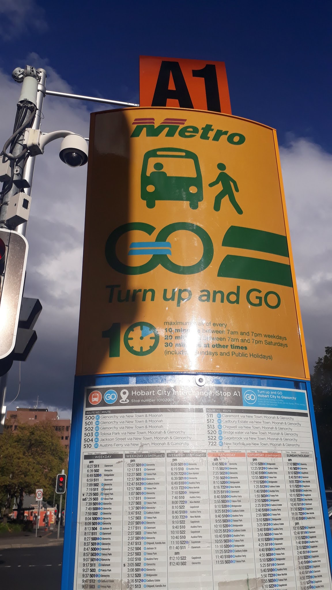
Can we learn from places where buses are the only public transport and are taken more seriously? Yes we can. Last week I was in Hobart and inspected their CBD interchange information. Below are some pictures and notes from that trip. 

Where Hobart does better

This is a blade-style totem at their CBD interchange. It is a bit like our SmartBus totems but there is much more information as you'll see shown later. 


Interchange map

These are pretty much unknown in Melbourne but they are very useful. They show where other routes depart from. Such maps are provided at every interchange bus stop. Hence if you're an alighting passenger needing to change to another bus you can see where it leaves from without having to walk to the interchange's entrance and back again to find this information (and potentially miss your bus). The latter is the rule in Melbourne because those who specify and design interchange information lack appreciation of their role and how passengers use them. (click picture for a better view)


Destination directory

This is another outstanding feature Hobart has compared to us. If you arrive at somewhere like Flinders Street or Southern Cross station and want to go somewhere not on the rail network you are on your own. The same applies for destinations along but not at the end of bus routes at suburban interchanges. Whereas Hobart's stops have a directory that can help even if you don't know the route number required. 


Frequent corridors highlighted

Hobart lacks trams. The nearest thing to them are its frequent corridors. One exists to the north towards Glenorchy while another operates east to Rosny Park. Service on these are every 10 minutes weekdays, 20 minutes Saturdays and 30 minutes Sundays, i.e. superior to Melbourne's SmartBuses at most times. Frequent network signage identifies stops that get this premium level of service. 

Melbourne's SmartBus concept sort of does that (for buses) but hasn't been extended to established routes that nevertheless approach or exceed SmartBus in service levels (eg 200/207, 216, 220, 223, 234, 246, 302/304, 402 etc).   

Also notable is the very prominent stand number which can help people locate where buses leave from (after having consulted the abovementioned interchange maps or destination guides). 


All departures listed in time order

Another good touch. Hobart does it. Melbourne often doesn't. Instead we spread times over several route-specific lists rather than have them in one. Such spreading makes it harder to see what the next departure is and obscures the overall frequency of service, especially for people going along a multi-route corridor. 

Psychologically the most anxiety passengers have is the moment they reach their stop. The first thing they want to know is when the next service is. A timetable with a single list of times puts their mind at rest quicker. Otherwise the risk, if there are multiple timetables to consult, could be them missing the bus they want, especially at busy stops serving multiple routes. 


Network maps

Most Metlink stops, even for local bus routes, once had them. But about 8 years ago they were replaced with material promoting myki. Apparently it was thought that the cost of updating them when bus routes were changed was too much to bear. But since then the pace of bus reform has slowed to a trickle so that point is no longer valid. 

Anyway, at least at major interchanges, network maps are essential. Those below are some of Hobart's. In contrast such maps are rare in Melbourne, even at stations with major bus interchanges (such as Frankston) or stand-alone bus interchanges (such as Monash Clayton). Adding them would greatly improve the navigability of the network at its most important stops and transfer points.  


Where Hobart does worse

While Hobart's central bus interchange is far better appointed for passenger information than almost anywhere in Melbourne, the minimum standard for stops away from the main interchanges is less. Here are some examples where Hobart is backward. 

No unified information style across operators

Melbourne got this to a refined art about ten years ago with its Metlink and Viclink brands and compatible styles for operators like Metro Trains, Yarra Trams and V/Line. Hobart hasn't. Metro basically serves the urban core while fringe and regional areas are served by operators such as Redline and Tassielink. Route numbers are part of the same system but information and fares are only partially so (Tassielink accepts Greencard but Redline doesn't).  


Sorry bus stops

I wrote about Melbourne's sorriest bus stops recently here. Hobart also has its fair share. If you are seeking to take regular (ie non-Skybus) public transport from Hobart Airport, you'll be greeted by this after you've done the required 40 minute trek to this stop behind an industrial/retail park. 


The bus stop is devoid of information. No route number, no destination, no timetable and not even a web address for information. 

A seat is nearby but apart from its obvious decrepitude, it warns of an unexpected hazard. 


Poor use of shop window space 

It's pretty much impossible to buy a Greencard (their transport Smartcard) in Hobart on a Sunday. There's not many outlets and it's common for them to be shut. And they don't have vending machines like we have with our myki. Still that's no big deal as cash tickets are issued everywhere. 

Their equivalent of our PTV Hubs is the Metro Shop. That has very limited hours, being a Monday to Friday only operation. It's on a street with many passers-by, right near the bus interchange. What got me though was its poor use of window space. At least when it's closed there should be a window display giving people some information about public transport and where to find out information online.

Possibly because of a government/bureaucratic legacy, public transport agencies aren't necessarily very  good at identifying patronage growth opportunities and marketing their services. Though to be fair it's not just a Hobart thing; South Cross Station is active outside the hours our PTV Hub operates yet it too has not made use of its ample wall space to provide information (eg large CBD maps) for passers by. 


Conclusion

There's a lot Melbourne can learn from Hobart in how we present public transport information, particularly at interchanges. We've neglected this a lot in the past as past Metlink work (though good) concentrated on lifting stop information up to a basic minimum standard to the exclusion of making interchanges easier to use. Hence there are many opportunities for improvement in Melbourne as part of public transport's post-COVID patronage rebuild.  


See other Building Melbourne's Useful Network items here

No comments: