If you want a sensible transit network you need a sensible street network. Buses can only go where the roads are. If they are too narrow buses can't run down them. Windy streets make for slow and confusing transit routes that are expensive to run per passenger carried. And their poor permeability can make walks to stops longer than they should be.
How road design cuts permeability for walking and buses
No person has harmed the ability to design and run good bus public transport more than the 1960s/70s road traffic engineer and their modelling and planning doctrines that remain too influential to this day.
Such designers, smitten by the clean lines and smoothly flowing illusion of Le Corbusier modernism, did not like the mixed land uses of towns and suburbs that grew organically. And it's true that some were quite noxious in a more agrarian and industrial age.
Neither did they like streets having multiple purposes, for instance as a thoroughfare, shopping strip, tramway, place to park, local access and frontage to many properties. That required numerous day to day interactions and was seen as fussy for a streamlined age (in the same way that ornate Victorian architecture fell out of fashion and was bowled over by the wrecking ball).
To manage the growing number of cars planners sought to separate out various land and road uses. Expensive schemes based on keeping the roads at level but elevating walkways and sinking trams (mostly) didn't happen here. But busier roads were widened (with property resumed) and/or (outside Melbourne) had trams removed to maximise car traffic throughput. Newer roads got made as controlled access highways with no property frontages or permeability for those crossing.
We were told these were safer per kilometre travelled (which wider roads induced more of). The biggest of these were freeways that punctured an existing finer grained road grid, making some short local trips inconvenient. Walking, if provided for at all, was made particularly hostile, with no passive surveillance and significant backtracking.
As sort of a trade-off for being ringed by busy roads the internals of planned neighbourhoods in cities such as Canberra were planned around a primary school and small group of shops. This was because at the time a lot of this planning was done most children still walked to school and car ownership amongst housewives and older people (in particular) was not universal. Footbridges over main roads were sometimes erected but their cost limited their number to a few sites mostly near schools. Also they were inferior to level access due to the extra ramp or stair climbing and lack of shelter they subjected users to.

The road hierarchy was based on cars coming off main roads (often at roundabouts) onto somewhat bent distributor streets and then very winding local streets intended to tame and slow cars. Culs-de-sac were sold as providing freedom from through traffic in family neighbourhoods but reduced permeability for walkers. 1970s era Radburn designs also featured internal paths to separate people from traffic. However this came at the cost of inferior passive surveillance that gave rise to fears of crime, especially in areas that were (or became) disadvantaged.
Unemployment (which ratcheted up in the mid 1970s and again in the early 1980s and early 1990s), falling family sizes, school sell-offs, the growth of the dual income family, higher car ownership, extended supermarket trading hours and larger drive-in shopping centres caused the closure or deterioration of local facilities. So although suburbs might have been internally walkable, there was less you could walk to within them.
While services in the next suburb may be walkable (as the crow flies), roads and roundabouts built purely for car throughput lessened directness and permeability. In theory longer but still local trips could be done by bus. However local street layouts (favouring T-intersections over cross roads that were considered less safe) hindered simple, direct and frequent bus routes. And typical 30 to 60 minute suburban frequencies made the buses we ran unattractive, especially if a connection was required.

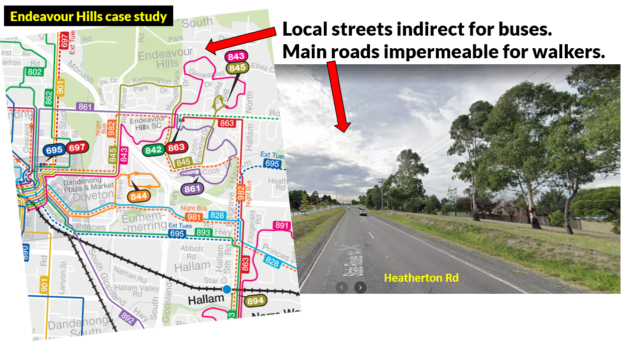
A similar example to Canberra suburbs like Weston Creek is Endeavour Hills in Melbourne's outer south-east. It got a
revised local bus network last year but the street layout constrained what could be done. Heatherton Rd is a potential corridor for a frequent bus between Dandenong and Fountain Gate that could serve a large catchment. However much of it is pedestrian hostile with poor accessibility and passive surveillance. The alternative, of having buses on local streets, is slow due to their indirectness.
Highways and (especially) freeways can not only sever where people can walk but also other roads that previously formed a finer grained network. That can reduce connectivity for short driving and cycling trips. In other cases the (dearer) freeway may be built but a more modest two to four lane road (that would complete a grid) might remain unbuilt. This can lessen the ability to plan efficient bus routes.
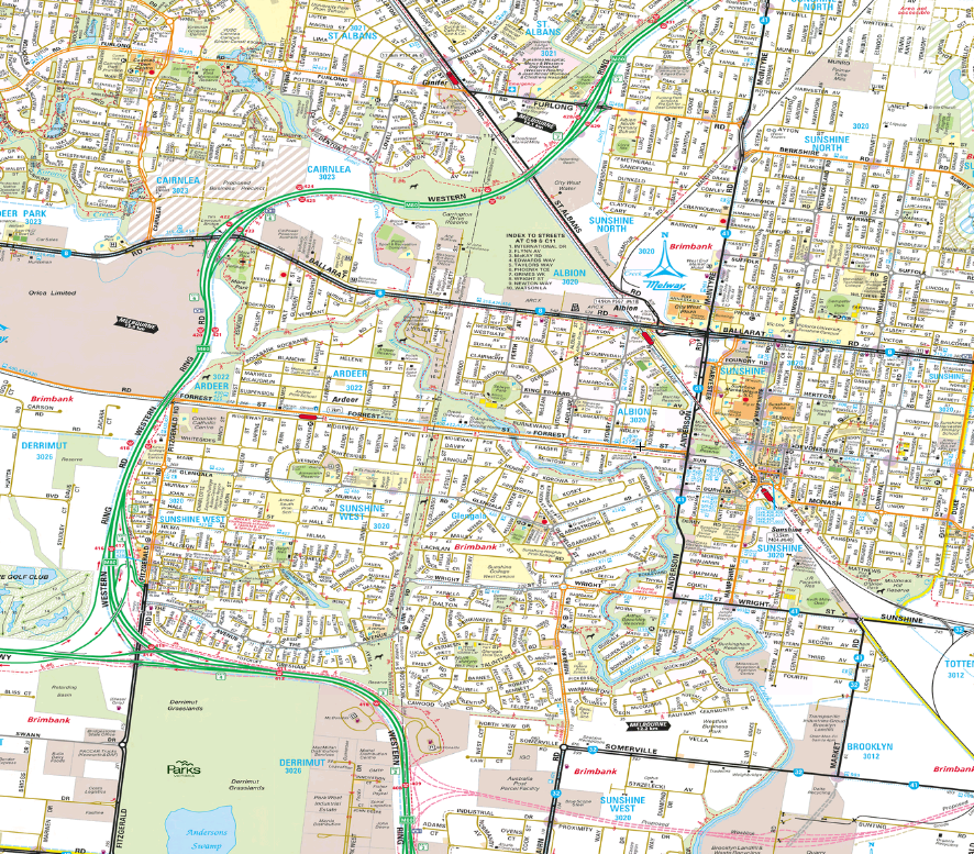
You can see the difference in the maps below comparing the Mt Waverley and Sunshine West areas. Mt Waverley has a complete road grid (with fair permeability, deteriorating at finer levels) and a freeway. Sunshine West has a freeway and an incomplete road grid that results in poor local permeability. Click on maps for more detail.

A larger view of the Mt Waverley area (but slightly north and east) is here. This gives a better idea of the usefulness of grid streets for grid transport services. Here north-south buses feed east-west trains and trams running towards the CBD. This is good geometry both for bus feeder / CBD train trips and also local travel where access is possible almost anywhere on the grid with one change. It is possibly no accident that the bus routes in the area are amongst the most productive in Melbourne on a passenger boardings per hour basis. Also as relatively few bus routes are needed to provide total coverage (provided streets are optimally spaced) then quite high frequency can be run on each one, further improving the ability to interchange between them. That's how it's meant to work; in practice Melbourne is weak at matching service level to usage with key routes like the
733, 737 and 767 still operating only every half hour at most times - similar to quiet semi-rural routes eg the
695.

How fine should transport grids be?
Having established that grids are good for transport access and interchange, how coarse or fine should they be?
It depends on travel speed. Walking grids should be finer than cycling grids which should be finer than public transport grids. Although if density and trip generation activity is high then you might have very fine grids for public transport, such as for trams in Melbourne CBD. Such grids of straight-running through routes is also more efficient than having everything terminate at a central interchange (which is more common for buses in smaller cities). Rail (especially if underground) is more expensive to build so would typically have wider spacings between lines, with reliance on feeder services to increase its catchment.
In the suburbs you want to provide good coverage and efficient routes. 400 metres is widely accepted as a reasonable walking distance to a bus stop. In practice people walk further (say 800m) especially to a faster or more frequent service (which in Melbourne is typically a train, tram or one of the relatively small number of frequent bus routes).
An 800 metre (ie half-mile) road grid would put everyone within 400 metres of a bus stop on one north-south and one east-west route of a hypothetical network. That assumes there is good pedestrian permeability mid-grid including the ability to cross main roads.
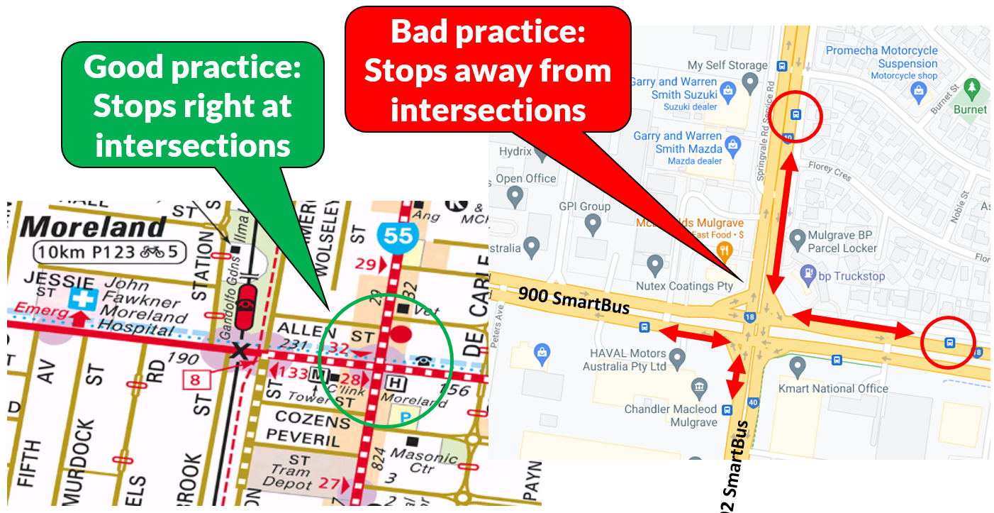
A 1600 metre (ie mile) road grid would do the same but require an 800 metre walk. Assuming the same number of bus resources as where the grid was 800 metres you could run each service twice as frequently and produce a better 'network effect' as waits are less for passengers changing between services. Apart from high frequency the latter requires stops right at intersections, something that Melbourne does increasingly poorly when you get beyond tram territory. Also it is even more important that there be good permeability within grids due to the longer walking distances.

The 1600 metre option risks leaving the less mobile that can't walk a half mile without service. A variant of this could be to add routes that operate mid-block to provide fill in coverage. In some places this is done. In others it isn't. Again poor within-block permeability can be a reason why it is not done in some areas - you simply can't get a bus through via any logical route. Generally speaking Melbourne's road grid gets coarser with distance from the CBD, with spacing approximately tripling from Elsternwick across to Knox. As the grid gets coarser the roads get wider (on average) with wider turning radii at intersections (bad for locating stops at intersections) and inferior mid-block crossing connections. Much of this is a result of conscious traffic engineering design decisions to maximise car traffic throughput for long distance travel above all else, including local accessibility via all other modes.
The maps below compare Mt Waverley (which has almost no mid-block buses) and Werribee / Hoppers Crossing (which does). Mt Waverley has not had a recent bus network review but it is unlikely that such a review would greatly change most routes as they are already direct. Werribee / Hoppers Crossing got its new network in 2015 with the main road grid getting direct routes for the first time. Its new network is basically two tier, with the main roads having more frequent service (typically about every 20 minutes) especially in peak periods. The in-between 'coverage' routes (Eg 161 - click to view map better) are typically every 40 minutes. The bus networks in both areas attract above average patronage per bus operating hour volumes.


To summarise, the optimum grid for buses in suburban areas is probably between 800 and 1600 metres. But if you were going to do the latter then some coverage routes would be desirable. That requires good midblock permeability (ie grids within grids) and (importantly) good connectivity between midblock grids to lessen the number of turns. Some newer areas have done this quite well, for instance the midblock route 151 in Truganina provides good coverage and delivers excellent patronage performance. I stress again that this would not have been possible if the roads weren't designed right.

Ideally every route would be frequent and you'd have an efficient network that provides good coverage from the main routes without need for low frequency 'in between' routes. You might be able to get away with a grid spacing of 1000 to 1200 metres, ie a maximum of 500 - 600 metres walk. The very furthest midblock areas could be open space (eg parks and ovals) in a square surrounded by family homes. Somewhat higher densities and mixed use retail would be near the main bus-served grid roads. This arrangement should ensure that the vast majority of residents would still be within 400 metres of frequent service in four directions despite the wider grid pitch.
The above would hold for new areas. In established areas near or between stations, the over-riding consideration is to have a grid that provides for direct roads running directly to stations to allow efficient deviation-free feeder services that can through-route if necessary. This was mostly but not always done in the past. Exceptions I can think of are Toorak and Malvern stations which have poor connectivity with trams (possibly as they were then considered rivals). But today it's important that new stations have locations and designs that facilitate efficient feeder service, especially given their longer distances apart.
8 gaps in the grid
The following describe some gaps in suburban road grids. These may impede the ability to operate direct bus routes to efficiently serve an area or provide linkages. The gaps may be due to a freeway, railway, private land or watercourse blocking what might be a potentially useful connection. While I will point out these gaps in the grid, I will not comment on the feasability of bridging them; for some the "horse may have bolted".
Possibly due its more fragmented development, there seem to be more gaps in the west and north than in the more continuously gridded east. Hence all seven are in these areas.
1. Hoppers Crossing/Point Cook
Parts are just a stone's throw from Hoppers Crossing Station and even closer to the Federation Trail. But it doesn't look walkable or directly driveable due to the freeway being in the way. Imagine how much better access would have been if Dunnings Rd had extended west to Hoppers Crossing Station.
2. Laverton
Freeway users can cross the railway via a road bridge but locals travelling cannot unless they divert via the (newly grade separated bridge) near Aircraft Station. The effect of this is that access from the low income and poorly served residential area north of Laverton Station to its nearest significant shopping centre at Altona Meadows is impeded. Bus passengers need to alight near the Laverton shops, go up and down the rail bridge then walk a significant distance to the inconveniently located south side bus interchange to get a bus to Altona Meadows. Or the more active might climb the Fitzroy St bridge over the freeway and walk to the centre from there.
3. Sunshine West
A middle-distance eastern suburb would have north-south roads every 1 to 1.5 km to form a grid. Not so in Sunshine West where such a road would provide a handy connection to the growing Sunshine Hospital precinct. It could make a bus route too, providing faster connections to jobs without having to go through Sunshine to change.
There's a lot of history here, including the alignment of the M80 Western Ring Road and the fragmented piecemeal development of housing (a little bit about every decade) in the Sunshine West and later Derrimut areas. The result is a very disjointed local road network with either missing gaps or sections where the limited access Western Fwy runs instead of a more permeable arterial roads. This limits where buses run so that residential areas have inferior connections to nearby employment areas in Derrimut and Laverton North.
4. Albanvale - Burnside
One of the big divides in Melbourne's west is between the City of Melton (including Burnside and Caroline Springs) and Brimbank (including Albanvale and Kings Park). The area is now almost entirely built out. But there's no east-west road connection in the three kilometres between busy Taylors Rd and Ballarat Rd. This means that even for local school and hospital trips people need to take these main roads. From the east Main Rd West (which lines up with St Albans Station) and Neale Rd (which goes to Brimbank Shopping Centre and towards Ginifer Station and Sunshine Hospital) terminate at Kororoit Creek. Rockbank Middle Rd continues east to the creek then still stops. Interestingly Rockbank Middle Rd become a different Neale Rd to the west, indicating a possible long term intention for there to be a through connection.
This discontinuity also stunts the bus network. Instead of routes that continue, linking destinations such as Caroline Springs to St Albans, they are forced to fold back on themselves. Trips that should be easy are not, requiring a lot of backtracking, waiting and changing.
Poor local transport access can create issues for schools with very different enrolment statistics for those in newer areas (eg Caroline Springs) versus established areas (eg Deer Park North). That can create cases where some schools are bursting while others have spare rooms (although it's not all about transport - there are also socio-economic, leadership, prestige and reputational issues at play that affects the relative fortunes of schools).

Burnside has been Caroline Spring's older but less known sibling with its average incomes being lower than newer areas. Parts were built before Caroline Springs got established. Met buses used to terminate there (eg the old 216 bus) even well after the Caroline Springs Town Centre got built a short distance away. Burnside suffered from poor connectivity in all directions except for Ballarat Rd to the south. It was only a few years ago that the Westwood Dr bridge was built to connect it to Caroline Springs town centre. When this was done the 426 bus (which replaced the
216) could be routed via the bridge to improve local connectivity. However as noted before Burnside and especially the newer Burnside Heights still lacks connectivity to the east.
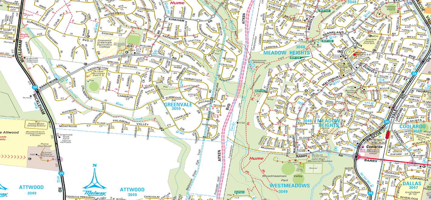
5. Greenvale - Meadow Heights/Coolaroo
Just above I mentioned the two Neale Rds that did not connect. A similar trick happens just on the other side of the airport. Greenvale has a Barrymore Rd that extends east from Mickleham Rd. Then shown in dotted lines on the other side of Aitken Bvd is Barry Rd. That runs quite near Coolaroo Station and then on past Upfield Station through populated suburbia. Barry Rd crosses Sydney Rd, narrows to become an industrial area road then stops at Merri Creek.
But on that same alignment another Barry Rd starts east of the Hume Freeway and runs a short distance to Edgars Rd, Thomastown where it finishes. This end is about 1km short of the main shops at Lalor and about a further 1km short of McKimmies Rd which runs directly to Bundoora RMIT.
The absence of a continuous road between Somerton and Broadmeadows Rd mean there's quite a few kilometres where there's no east-west connection. Greenvale is quite low density but faster growing areas west of Mickleham Rd are not. For buses it means that Greenvale routes cannot feed trains at the nearest station of Coolaroo. Instead they must go south and then east along indirect local streets. Or people backtrack to Roxburgh Park Station.
With wetlands, grasslands, a freeway, two creeks and significant private property, I can't see Barry and Barry joined at the Thomastown end any time soon if at all. But one should be aware of how the lack of connectivity has shaped the bus network. Again it has caused local bus routes to fold in on themselves, lessening access to areas just to the outside.
6. Airport West - Glenroy
For years it never had transport. Then Gowanbrae people complained. It then
got a flexible route bus to the Airport West shops and tram terminus though usage isn't high. This is a prime case of a hemmed in suburb that shouldn't have been built being developed. It has man-made and natural boundaries on all sides and just one road in and out.
Crow-flies though Gowanbrae is only a short distance from Glenroy Station. If there was a way of getting a bus from there to Airport West with better road permeability then Gowanbrae would be connected into the network. Such a route would likely prove successful as it would attract some through passengers from both directions given how much time it could save compared to the existing indirect train + bus trip via Broadmeadows.
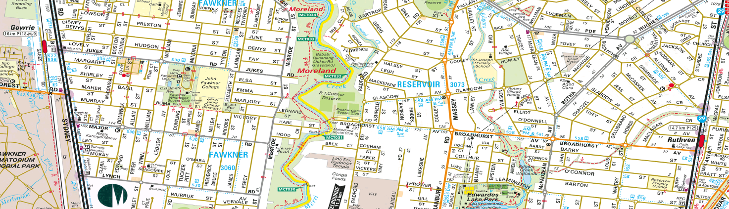
7. Fawkner - Reservoir
Here's another east-west gap in Melbourne's north. Its presence makes Fawkner inaccessible from the east and Reservoir inaccessible from the west. If there was a road through (even if single lane/bus only) an extended bus route
536 (currently Glenroy - Gowrie) could provide a potentially useful link across the north. Also it would allow a tidying up of the very complex routes
553 and
558 in the area (although there are
other ways to simplify these without involving the 536).
8. Watsonia North
Except (possibly) as a faster route for dead-running Dysons buses to return to their depot, the Metropolitan Ring Road does nothing good for public transport access. In fact it could be the reverse. Had its alignment been instead used for a non-freeway road with more access points it would provide a means for public transport to serve currently unserved Watsonia North and parts of Bundoora with a direct RMIT - Greensborough route. But this is not to be. The area either has no walkable public transport or partial coverage from the confusing and duplicative route
566.
Conclusion
I'm not going to claim that all these road gaps could be economically bridged now. However transit access in these areas suffer because of them. Their existence highlights how important a continuous yet permeable grid is in providing a useful on-road public transport network. Or even any sort of service at all.
Bad geometry, including the non-availability of a road grid for transport access, should be grounds for refusing development permission for new suburbs or density increases in established but inaccessible locations. Also road infrastructure investment should be channelled to completing grids in areas that currently lack them especially where this enables improved walking, cycling and bus access. The example from Perth below shows how simple and cheap grid completion can be where in favourable circumstances.
For now though it's over to you. Where else in Melbourne is our road grid broken? Where would completion of it allow better transit access? And are there places where cheap remedies are possible like in the Adie Court example. Comments can be left below.


1 comment:
With your first example of a link between Hoppers Crossing and Point Cook, I think there is a strong likelihood that Dunnings Road will ultimately be extended across the freeway to provide a connection to Hoppers Lane and better connectivity to Hoppers Crossing Station.
If you look at the property boundaries at the western end of Dunnings Road you will see that they are splayed to allow for a bridge to be constructed.
Unfortunately I think most of your other examples will be harder to solve.
Probably the one I find most disappointing is the absence of a link between Albanvale and Burnside as the Burnside area was developed relatively recently. For years there was an unused road reservation that existed to the west of Station Road in Albanvale for the purpose of a road connection that has now been partially sold off for housing and includes McCann Drive. I can't help but think that the fact that there is a municipal boundary at Kororoit Creek between Melton and Brimbank had a lot to do with the absence of a road connection.
Whilst it is unlikely to be a major road, I guess there is still a small possibility that McCann Drive could be extended across the creek to connect with Rockbank Middle Road as I note that the houses on the south side of McCann Drive have double frontage without any driveways fronting McCann Drive. This suggests that McCann Drive has been designed for something more than just your average local street.
Post a Comment