
In Broadmeadows case it was Ford whose plant was near Upfield station. This was the 1950s and suburb zoning and development was not as autopic as it would become within a few decades. Hence it was possible for people to live in Dallas and walk or cycle to Ford. Meanwhile housewives would have been able to walk to shops on Barry Rd or Blair St and children to the area's once numerous schools.
Such walkable accessibility would not be available in a 2019 development.
Today's factory or distribution centre would have been built well off its main road in the middle of an industrial estate made remote from housing by restrictive zoning, absence of grid streets and uncrossable roundabouted roads. Large turning radii would mean vehicles can turn with speed and convey the message that they need not give way to pedestrians. Shops are in fewer, larger clusters, set behind parking, while schools are bigger and further apart than they used to be. You can see all this in newer areas like Tarneit/Truganina where although housing is creeping towards the industrial area walkability between the two is not provided for.
Getting back to 'Broady', the area has been known as a 'Struggletown' but up until the 1970s the vast majority of households had at least one breadwinner. It has borne the full effect of post-1973 economic change including lower tariffs, the end of 'full employment', the shift to a services economy, outsourcing, international competition and the weakening of labour market protections.
The Button car plan of the 1980s sought to reduce the number of car models produced in Australia to make production runs more efficient while reducing industry protection. The free-trade sentiment at the time led to falling tariffs in other fields from about 1990. This, combined with the recession which hit Victoria harder than any other state, deeply affected industrial sector employment.
The Broadmeadows area was in the front line and never fully recovered. Today it has some of Melbourne's lowest median incomes and highest jobless rates, having degentrified from a lower-middle to a very low employment and income area. This is why I discuss the area in my submission to the disadvantaged jobseekers inquiry.

Existing Useful Network
I explain the Useful Network concept here. It's those routes that are frequent enough and run over long enough hours to be useful for many trips. I've specified a 20 minute frequency on weekdays and 7 day service until 9pm. In other words the coloured lines on the Melbourne Public Transport Frequent Network map with the 20 minute frequency selected. This map shows the sparsity of Useful Network routes in most fringe areas, despite their sometimes high population densities.
Below is the existing Useful Network for the Dallas/Coolaroo area. It's fairly sparse. Trains on the Craigieburn and Upfield lines skirt the borders of these suburbs. East of the Craigieburn line the three Useful Network routes are two SmartBus orbitals and one regular route (540). This runs from Broadmeadows to Upfield. It does a loop in Coolaroo. Before Coolaroo Station was built the 540 was the only public transport in the area that did not necessitate crossing the railway and busy Pascoe Vale Road. Route 540 operates every 20 minutes on weekdays and 40 minutes on weekends with a 9pm finish.

The area around Sydney Rd is a transport 'black hole' with no or infrequent service. This is despite it having substantial residential and workforce populations. Service is particularly low in the Campbellfield area. Even on parts of Sydney Rd, traffic volumes and the lack of pedestrian lights at human-scale intervals make its stops effectively inaccessible.

The map below shows all routes. Notable routes not on the map above are the 532 up Sydney Rd (every 30 minutes, unharmonised with trains) and the pair that attempts to serve the residential part of Campbellfield (531 and 538). They run 5 and 6 days per week, with no Sunday service. The main overlaps in this network both concern the 538; that with the 531 in Campbellfield and that with the 902 along Camp Rd.
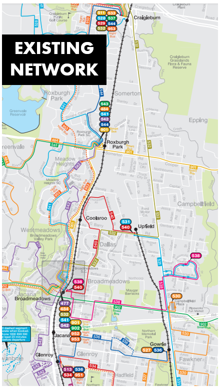
The area's main transport network change has been the opening of Coolaroo Station about 10 years ago. Buses however have not changed significantly with the 1992 map below similar to 2019's network. The main change is that the 560 got incorporated into the 902 and the 319, which was a substitute for when the Upfield train wasn't running (the line then being a part-time service) got deleted when train services were upgraded.

Patronage of existing routes
The busiest local route is the 532 with 35 boardings per bus hour on weekdays. This exceeds the 26 boardings per hour of the 540, the next busiest route. 532's result is amazing given much of its catchment is so pedestrian hostile. On paper it provides a handy connection from the Upfield line to the Craigieburn line but in practice its effectiveness is limited by its 30 minute frequency not meeting trains every 20 minutes. While the quieter route, 540 has a 20 minute off-peak service as opposed to the 30 minutes of the 532.
Both 531 and 538 are quiet, with weekday boardings of 11 and 14 passengers per hour. Reasons for these low numbers include the considerable overlap that these routes have with others in the Fawkner and Campbellfield area.
Similar patronage patterns apply on weekends with 532 again being busier than 540. 532 is once again unharmonised with trains on Saturday, with its 30 minute frequency not providing reliable connections. Sunday service meanwhile is hourly, a lower service than the 540 which is every 40 minutes on both weekend days.
Existing bus resources
I estimate that the area's local bus network requires 7 buses, distributed as follows:
531 = 1 bus (1 hour return trip, every hour) - Broadmeadows Bus
532 = 3 buses (1 hour return trip, every 20 min in peak) - Broadmeadows Bus
538 = 1 bus (40 min return trip, every 40 min) - Dysons
540 = 2 buses (40 min return trip, every 20 min) - Dysons
The area's local bus review
About 10 years the government commissioned a bus network review covering the area (Hume/Moreland).
Key recommendations included a bus up Widford St (to replace the duplicative 538 along Camp Rd), connections into the industrial area east of Sydney Rd and a simplification of services in the residential area of Campbellfield.
None of this got implemented. The entire area is the ultra-safe Labor seat of Broadmeadows held by Frank McGuire MP.
Presented below is a revised network. It's greatly simplified compared to now with just two routes: 531 and 532.
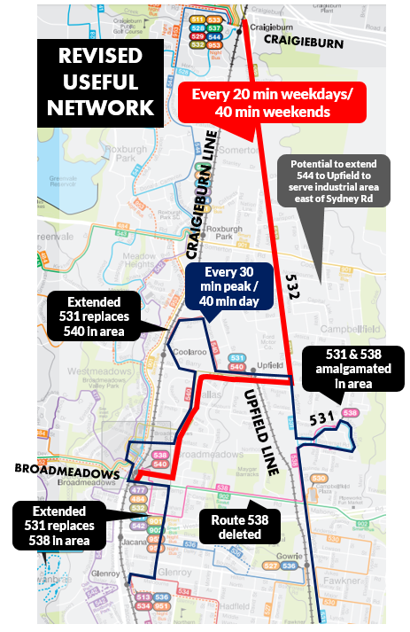
Route 532 becomes the area's main road route with a weekday service boost from every 30 to every 20 minutes to harmonise with trains. It's the only bus serving many jobs on the Sydney Rd corridor and connects Craigieburn with Upfield. In addition it provides a strong service through central Dallas. On weekends Route 532 could run every 40 minutes, harmonising with trains on Saturday and providing improved service on Sunday compared to the current timetable. An option exists to add one or two short Broadmeadows - Upfield trips around 10pm and on early Sunday morning to improve operating hours in high need areas remote from stations.
Route 531 (thinner line) is the other route. It is amalgamated with Route 540 and replaces Route 538. A basic 40 minute frequency with 7 day service is suggested. Peak frequency could be every 30 minutes. Both would be a frequency increase over the current hourly service.
The upgrade is necessary to compensate for the removal of Route 538 (every 40 minutes) from the residential portion of Campbellfield east of Sydney Rd. This is still fewer buses per hour on weekdays for the area. However service overall is increased with evening, Saturday afternoon and Sunday buses introduced. 531 morning peak service to Upfield is vastly improved, going from every 120 min to every 30 min. And the amalgamation with Route 540 means that the single seat ride to Broadmeadows (currently available on Route 538) is retained. It's less direct but the improved operating hours and 7 day service more than compensates.

What happens to the 540, currently the area's main Useful Network route? It gets incorporated into the extended Route 531 mostly every 40 minutes. This change does not greatly reduce Useful Network coverage because 540 mostly overlaps with Route 532 that gets a service upgrade. Most of the areas where it doesn't overlap are within the 800 metre catchment of Coolaroo Station, which wasn't built when Route 540 was last scheduled. Because both 531 and 532 get a 40 minute service on weekends, it may be possible to stagger their times to provide an 'every train' connection from Upfield.
The Olsen Place shops on Widford St south of Camp Rd doesn't have a bus going right past it. All it has is the part-time Monday to Saturday morning 538 on Graham St. This would be replaced by the extended Route 531 which provides new 7-day connections to Broadmeadows and Glenroy. It is unlikely that many will need to go to Campbellfield but if they wish to they can remain on the bus.

A Widford St bus connecting the area to Broadmeadows and preferably Glenroy is essential for coverage but it doesn't have to be the 531. Another network option could terminate the 531 at Broadmeadows and have Widford St served by an extended route from the Glenroy, Hadfield or Coburg area as discussed last week. This would improve the network's legibility as 531 would be less direct. And a southern extension to Coburg would make it more useful for more trips.
Paying for it
How much would this network cost? It's not much. The number of buses required appears the same as what's used now. The main difference is that the buses are being worked harder so there's some higher fuel, labour and maintenance costs. However fare revenue should be higher due to the network being more useful.
Here's how buses could be allocated between the revised routes.
Here's how buses could be allocated between the revised routes.
531 = 4 buses (2 hours return trip, every 30 min peak, 40 min off-peak and weekends)
532 = 3 buses (1 hour return trip, every 20 min all day weekdays, 40 min weekends)
532 = 3 buses (1 hour return trip, every 20 min all day weekdays, 40 min weekends)
538 = 0 buses (replaced by extended 531)
540 = 0 buses (merged into extended 531)
Given that one operator currently runs three buses and the other four and both routes gain increased bus hours (532 mainly interpeak and 531 mainly weekends) it should be possible to arrive at a fair arrangement where both gain.
540 = 0 buses (merged into extended 531)
Given that one operator currently runs three buses and the other four and both routes gain increased bus hours (532 mainly interpeak and 531 mainly weekends) it should be possible to arrive at a fair arrangement where both gain.
Loose ends
The above has sought to expand the 20 minute frequency Useful Network to more local people and jobs without needing to buy more buses. However there are two key things that the above network leaves aside.
The first is a residential area coverage gap south of Geach St. Parts are walkable to Upfield Station (if you count 800m as acceptable). However it's a low income area and bus access to local destinations is limited.
The first is a residential area coverage gap south of Geach St. Parts are walkable to Upfield Station (if you count 800m as acceptable). However it's a low income area and bus access to local destinations is limited.

I considered the possibility of diverting Route 532 through the area but this would reduce frequency in areas that currently have the 540 every 20 minutes. Other possibilities would require additional routes and buses.
The second omission is lack of connections to jobs east of Sydney Rd. The likely solution is an industrial-type route from Roxburgh Park to Upfield and/or Broadmeadows. This could potentially serve the Geach St area mentioned above. Extending an existing route from Roxburgh Park (eg 544) could provide some residents with a direct bus to their workplace.

Conclusion
What do you think about this network? Is swapping the highest service route from the 540 to the 532 a good idea? And do you like the extension of 7 day service to all routes? Please share your thoughts in the comments below.
3 comments:
The 531 might be getting a bit too long winded and illegible if it goes to Glenroy? A stronger cross suburban link from Broadmeadows to either Coburg or Reservoir (see my comments for a Fawkner bus bridge last week) would be more useful that taking the Wilford St section onto something from Dallas area.
Adding a third route in Dallas along Lismore St, Hepburn St and King St in Dallas would be worthy, off-set with the 531 (or 540) out of Broadmeadows. This could be the route that continues into the industrial area east of Sydney Rd too.
Ideally you'd want to offer half-hourly service in peaks to make it worth the effort and attract some use. 40 mins outside these times would be OK, especially if 532 went to 20 mins on weekends, maybe just an extra bus shuttling Braodmadows - Upfield depending on budgets.
Half-hourly would also allow you to line-up with start / finish times in the industrial estate somewhat.
Agree the 531 to Glenroy is illegible. I wanted a network solution that could work stand-alone, though ideally it would be integrated with at least some of the Hadfield/Glenroy changes the previous week. That had three options and I didn't want anything for Dallas/Broadmeadows that would close off any of those.
I like the third route concept. Needs more buses/money. Good point about 30 min peaks. I wonder if there are a lot more on the hour or on the half hour starting times than :15 and :45. If so then one might aim for buses to be approx 15 min before common start times and 15 min after common finish times (not sure how rigid these are in the industrial sector - in something like retail they can be 15 min or (much) more after shop closing time).
With the advent of an ageing Upfield populus and influx of a decade of new migrants.What should be proposed is 1 more train platform after the Campbellfield schematic submission ie. An additional Geach st train stop as the recessed contour of the existing rail line is ideally suited.This would allow commuters from Kingston Gardens estate as well as Upfield/Campbellfield residences closer walking distances.Additionally then also re-route the existing bus schedule from Upfield/Barry Rd thru to Garner Parade to stimulate commuter accesibility making the Upfield Station connection to Roxburgh Train extension more viable.Cyclists also would be encouraged to commute along this neglected corridor with the completion of the long awaited Upfield Bike Path extension from Box Forest Road to Upfield.
Askin Utlu
Post a Comment