
Most Useful Network items are about simplifying infrequent local bus routes to build an economical network of more direct buses operating every 20 (or occasionally 10) minutes. Such revamps are necessary for vast swathes of Melbourne suburbia that now see only indirect and infrequent buses.
However we also need buses to take on more of a rapid transit function. We've done it a bit for corridors that stand in for sometimes proposed railways like City to Doncaster or Huntingdale to Rowville. However these are both radial corridors. More than these are needed for a full connected network.
Many plans (eg Melbourne @ 5 million) have advocated growth in suburban centres or, more nebulously, clusters to decentralise jobs and activity. These need rapid access from multiple directions to reach their full potential. Frequently stopping buses stuck in traffic excite few people, even if they run every 15 minutes like a SmartBus. One concept that can work is a frequent express service between a large destination and a major interchange, such as the Route 401 example below. Perhaps the most significant thing about this one is it's a circumferential link. Hence it complements, and even relieves stress on, the existing radial network. That's important where this is already running close to capacity.

Transport demand
I will not go into travel demand modelling in any detail (though you can here or, if you want a quicker read, then here). There's other factors, but very roughly if centres are big and close to one another there are likely to be many trips between them. Make them further apart and the centres are more self-contained, meaning fewer trips. There are also fewer trips where centres are smaller. It's a bit like gravity, hence the name of the theory. A rough diagram is below.

When there's many trips you will need capacity. More than one two lane road (even with buses) will be needed. Congestion will build up. There will be a need for real mass transit, including dedicated high capacity modes like rail on their own rights of way. These create a speed and convenience edge over driving and thus higher modal share for public transport (indicated by the green parts of the link lines above).
Another approximation is below. Larger centres not only attract more trips but attract more on public transport as this is the most efficient mode for trips to large centres. The CBD is the stand-out as you can see on the top right.
Another approximation is below. Larger centres not only attract more trips but attract more on public transport as this is the most efficient mode for trips to large centres. The CBD is the stand-out as you can see on the top right.

Some cities do better than others. Eg Sydney has a less radial rail network and busways between some of its major outer suburban centres. Its non-CBD centres (eg Chatswood, Parramatta) get higher public transport modal share than do equivalents in Melbourne. But even within Melbourne's there can be a lot of variability. University precincts like Monash Clayton and shopping centres like Chadstone can do relatively well despite lack of rail.
Other non-rail centres, and especially industrial and airport precincts do very poorly, not least due to poor service levels. Smaller shopping centres can be more car-oriented than larger centres. Though not in all cases. A medium-sized centre such as St Albans, in a low income area, has very high numbers of shoppers who arrive by bus.
In many areas local councillors and retailers underestimate the number who reach their shops on foot, bike or even bus as they push for more parking. Cars, due to their movement and storage requirements requiring use of scarce land, are spacially inefficient. At high speeds and in large volumes they are also a nuisance for users of all other transport modes, including walking, cycling and buses.
Centres that aspire to be some place better cannot afford to have their retail turnover and job numbers artificially constrained by car parking and movement (which crowd out efficient transport modes and denser development). A centre that wishes to grow needs public transport to provide an increasing proportion of new trips that its growth generates. For this to happen public transport accessibility from multiple surrounding areas needs to be good.
Access and connectivity mapping
A good way to assess this is by looking at SNAMUTS connectivity maps which have been prepared for various cities including Melbourne. I'll leave it to you to read the fine print on what each map means. In layperson's terms you can use these maps to check things like an area's connectivity to other destinations, population catchments and overall accessibility.
It's important to be aware that there are minimum service standards very similar to the 20 minute criteria I've used for the 'Useful Network'. This accounts for the large dollops of 'Urbanised areas without minimum service' on the SNAMUTS map below (black).
The impact of existing Useful Network routes including orbital SmartBuses is clear on the map. However they are mostly red or orange. They are too slow to give their catchments yellow (ie above average) accessibility like you see on rail corridors out to Box Hill, Oakleigh and around Sunshine.
The impact of existing Useful Network routes including orbital SmartBuses is clear on the map. However they are mostly red or orange. They are too slow to give their catchments yellow (ie above average) accessibility like you see on rail corridors out to Box Hill, Oakleigh and around Sunshine.

To improve accessibility you basically need fast and frequent connections. In mass transit speed is constrained by the number of times it has to stop and, critically, if there is impediment from cross-traffic (which can include walkers and other public transport services). Frequency is proportional to the number of buses you can put on and inversely proportional to travel time. So if you have fast travel times (especially if there is low variability) you can achieve high frequencies.
People throughput is a function of frequency and vehicle capacity, so if you have large vehicles like articulated trams or buses then you can carry huge numbers of people per hour provided that they face few impediments. Fare revenue per bus operating hour is also higher.
Route 401 between North Melbourne and Melbourne University, for example, has 66 passenger boardings per bus operating hour, about three times the average for Melbourne buses. 301 between Reservoir and La Trobe achieves 74, while 601 between Huntingdale and Monash University attracts over 200 boardings per bus service hour. These are all buses operating on roads with traffic lights.
The ideal would be something that approaches this definition of a wormhole.

In practice we don't need instant. We just need short. The maximum speeds of our trains, trams and buses are already plenty high enough. What's important is that they are kept moving at a good speed for most of the time. Even our suburban trains rarely exceed 35 km/h average despite their maximum being three or so times times this. Buses average around 22km/h while trams, due to mostly running in mixed traffic, are in the teens. Add waiting and connection times and overall end-to-end speeds may be halved.
If we added some fast and frequent connections we could fill that SNAMUTS accessibility chart with lots more green and lots less black. More precisely, 20 minute-style Useful Network routes would turn black to red in the outer areas. Closer in some short, fast and very frequent links would turn orange areas to yellow and yellow areas to green with vastly improved accessibility. There could be particular gains at centres we wish to build up including around Sunshine, Box Hill and the Chadstone-Monash precinct.
The gradual approach (which should be done on a larger scale) are initiatives like more bus lanes, more priority at lights, articulated buses with dual leaf doors, and higher frequency, potentially including headway managed turn-up-and-go timetables. Sometimes unforeseen events can lead to unexpected progress, for example we now have all-door boarding due to COVID-19 social distancing.
All this could be considered a poor man's BRT as part of a SmartBus 2.0 refresh. Their cost-effectiveness would be exceptional and they would spread benefits to large areas. However on their own they may not be seen as the sort of high-profile step change that something like a new rail link might involve.

The 'bus wormhole' concept
An advance on the gradual approach could be the 'bus wormhole' concept. This is both infrastructure and service heavy. Buses would be fully separated from traffic, operating on their own way (which could be elevated or underground in parts where land is unavailable).
Costs per kilometre would be very high. Consequently 'bus wormholes' would be short sections on the busiest corridors in the most intensive suburban clusters, preferably intersecting or feeding trains at least every 10 minutes. Favoured locations might include major off-rail locations such as universities and shopping centres (some mapped here) that are much less accessible according to SNAMUTS than a railway station a few kilometres away.
Wormholes may have either dedicated routes (such as short shuttles like the 401) or be used to speed up the busy ends or middles of longer through routes (including some SmartBuses). You might only have five or ten in all of Melbourne as each might cost in the hundreds of millions to low billions depending on length and complexity.

You can imagine their role as per the diagram below - bringing key nodes together to greatly increase connectivity over a wide area. Before and after SNAMUTS maps to show each wormhole's impact could be used to evaluate the merit of various proposals.

10 bus wormhole concepts
Where might you consider bus wormholes? Location could be affected by the extent to which one would speed service relative to much cheaper BRT-light priority treatments, how it would fit in with other transport projects (eg Suburban Rail Loop) and expected patronage per kilometre of wormhole. Then of course there is cost and feasability, including whether there is room to operate a bus way at-grade (cheapest), elevated (dearer) or underground (dearest).
In all cases the interface with trains must be of a standard better than we've had in Melbourne, for instance via escalators, ramps or lifts directly onto station platforms. The gold standard is what you see below from Adelaide where changing involves just a few steps.

Potential wormhole locations include a mix of inner, middle and outer suburbs. Some might only be 2km long, with future extensions further speeding travel. I have deliberately not shown the exact route alignment or specified whether they are at-grade, elevated or underground. Below are concepts worthy of discussion (and, yes, there are some wild departures from the normally cheap and sober proposals normally considered here).
1a. Footscray - VU - Highpoint (orange line). This wormhole connects three major closely spaced destinations. Footscray is the west's biggest rail hub that already enjoys 12 trains per hour to the CBD. It's set to get even more important with the Metro Tunnel. VU and especially Highpoint are major destinations remote from rapid transit. Services using it would likely be a merged 223/406 bus with services extending beyond the wormhole to Avondale Heights (Milleara Shopping Centre) and potentially beyond. A key consideration would be considering its value for money versus an upgrade or even rerouting of the almost parallel 82 tram, which in its current form is infrequent and does not run past the door of VUT or Highpoint.
1b. Highpoint - Essendon (red line). This would provides a much stronger link between the inner north and Highpoint by providing fast access from Essendon. It would be introduced in conjunction with a rerouting of the red orbital SmartBus between Essendon and Sunshine via Highpoint instead of Avondale Heights. As compensation the above orange route (Route 406) could be extended from Avondale Heights to Sunshine to replace the 903. Both routes would need to be much more frequent than their current 15 to 20 minutes to justify the infrastructure cost of the wormholes. A cheap service-only variation of this scheme was described here.

2. Northern Hospital - Epping. This is a short wormhole so would be cheaper than most others here. However it connects major destinations slightly beyond the station's pedshed with a rapid transit service. The wormhole would serve multiple routes including the 901 orbital and new bus rapid transit using the Wollert Transport Corridor reservation. From there routes could fan out to directly serve multiple residential areas, similar to Doncaster's DART network, with one continuing to Craigieburn despite some potentially restricted catchment near the Hume Fwy. Although the wormhole would finish near Epping Station routes could continue east along Childs Rd as a SmartBus type corridor to at least Plenty Rd/Bundoora RMIT to allow a connection with the 86 tram to La Trobe University. Also, an extension of one route to Greensborough, potentially via the Metropolitan Ring Road, could be a consideration if sufficient demand exists for a fast east-west route. This could provide a faster connection than the current indirect and underused north-east portion of the 901 SmartBus or the confusing Route 566. An upgrade of Mernda line trains from every 20 to every 10 minutes off-peak would be required to get full potential from this wormhole.

3 Preston - Heidelberg. Suggested as it is an east-west strip with a large number of major destinations and intersecting lines. A wormhole might only include the most congested sections. It's basically a gold plated version of the cheap 904 Megabus proposal described here. Potential exists for a western extension to Coburg and a more direct connection to Essendon, linking with a previous concept for Highpoint. This would weave the currently heavily radial system in Melbourne's north into a true network with fast travel in all directions.

4. Reservoir - La Trobe University - Macleod. Basically an advance on the existing very successful 301 shuttle bus from Reservoir. The worth of this wormhole depends on the travel time saving relative to (a) now or (b) lower cost bus priority upgrades. Boosting Reservoir and Macleod off-peak train service for every 20 to every 10 minutes would produce travel time gains without the infrastructure spend so you'd do these (and smaller bus speed improvements) first before considering this wormhole.

5. North Melbourne - Melbourne University - Clifton Hill. This is an advance on the existing very successful 401. The Clifton Hill extension should save travel time for this currently slow cross-city connection. Melbourne Metro's Parkville station would allow further travel time savings for trips like Clifton Hill to Footscray. There are many intersecting tram routes in the Fitzroy area, but as shown on the map you would only connect with some due to the need to retain good travel speeds.

This wormhole alignment links two major stations with numerous lines. It is deliberately fast with wide stop spacing. Caulfield will assume greater importance in the future with the Metro Tunnel connecting there, a major university campus and the development opportunity presented by the under-used Caulfield Racecourse. This wormhole needs to be considered relative to other approaches including (a) extending the Burke Rd tram south to Caulfield or (b) an alternative scheme involving extending the Alamein line to East Malvern and Caulfield. About the only thing that's certain is that apart from an on-road bus connection as an initial stand-in (highly desirable), no fast transit option in the area will be cheap.

7a. Caulfield - Monash University (orange line). This is basically a section of the very popular 900 SmartBus bus on steroids. A wormhole would reduce the time it wastes around Chadstone and Oakleigh. The map has it skipping Huntingdale to save a stop since it's assumed that the 601 would perform this shuttle role. Labor proposed a light rail for this route in 2018 but little has been heard recently. The Chadstone to Oakleigh wormhole could also be used for the numerous buses that operate between Oakleigh and Chadstone with some substantial travel speed savings benefiting routes as far away as Dandenong.
7b. Box Hill - Deakin University - Holmesglen - Chadstone - Oakleigh (red line). This is another north-south link serving major destinations. It's a fairly similar alignment to the popular 903 orbital except for the inclusion of Deakin University. A major benefit would be to speed travel between Oakleigh and Holmesglen, which, despite being short, can take a long time due to the indirect running via Chadstone. Other benefits include better Homelsglen and Deakin University connections to the north and south. Potential exists to extend north to Doncaster, with a potential station near the hospitals at Box Hill. This is one of the dearer wormholes but the intensity of development may make it worthwhile. Note though that the Deakin to Doncaster section would duplicate the proposed Suburban Rail Loop.

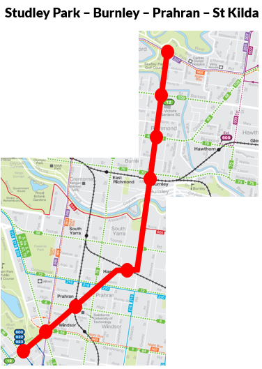
8. Studley Park - Burnley - Prahran - St Kilda. This wormhole has more closely spaced stops than the others. Maybe it should be a surface BRT/light rail rather than a wormhole. Whatever the mode, it would help people make a lot of trips that are currently very inconvenient provided its frequency is high and operating hours are long. These include segments like Victoria Gardens - Burnley, Burnley - Prahran and Hawksburn - St Kilda. Trams at St Kilda Junction would also gain new connections. Stopping Metro Tunnel trains at Hawksburn would provide access benefits for those as far away as Dandenong, Pakenham and Cranbourne. Construction would not be a trivial exercise but the area's increasing density and number of trips it would improve could justify it.
9. North Richmond - Richmond - Anzac - Southbank Southern Cross. This is an inner-south ring intended to work in with the Metro Tunnel. It would improve travel from Anzac to CBD fringe areas without having to go into the CBD. Is this necessary? After all all but one stops are served by rail, with Southbank having many trams. Most trips would be possible after (a) the Metro Tunnel and (b) after the confusing City Loop operations have been tidied up even without the wormhole. On the other hand it could be desirable as a core capacity enhancer, a bit like how the 401 bus diverted trips that didn't need to be via the CBD core to make way for trips that needed to be. But you wouldn't build this wormhole until vastly cheaper (in fact negative cost) capacity freeing projects like scrapping the Free Tram Zone are done.

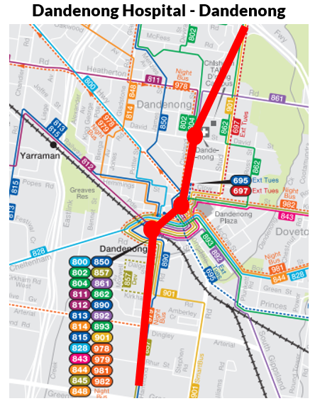
10. Dandenong Hospital - Dandenong. This is another short wormhole similar to the one suggested for Epping. Again it provides fast access between a major station, shopping area/market, hospital and TAFE. Many local routes and the 901 SmartBus could be routed through this to speed local and semi-local trips, including to jobs at Dandenong South.
Bus wormholes are expensive infrastructure projects of the type that (in Melbourne at least) we associate with trains much more than buses. What do you think of the concept? Are they an expensive waste benefiting only a few spots when much smaller sums could finance at-grade improvements for bus flow at many more sites? Or are the mobility benefits at and through densely populated areas sufficient to make the concept worthwhile? Also if you have ideas for other wormholes please leave them in the comments below.

4 comments:
"New bus rapid transit using the Wollert Transport Corridor reservation."
Would bus rapid transit be replaced soon enough with passenger heavy rail?
No. In that case, keep that reservation for railway. Buses should be able to use Edgars Rd with no (or at least minimal) hindrance from other road users.
The issue I have with taking up the railway reservation for buses is that groups of cyclists would still not be able to ride up north without physical effort due to the elevation profile of the suburb. Not many bikes would be carried on the buses. The existing Shared User Path along the WTC would also have to be totally reconstructed to build the BRT lane, meaning so much disruption to path users at that time and in future again when rail is developed.
Until railway is developed, it should be possible to improve the bus services along Edgars Rd which closely parallels the Wollert Transport Corridor.
As outlandish as some of these proposals seem Peter, some have a level of potential, to which decent BRT wouldn't be too much of a extreme option.
Footscray, I'd only run as far as the current hospital site, bringing it up in the current station carpark. Simple and low cost, with limited stations and exit points might do it favours.
Epping and Dandenong, I can actually see getting off the ground with decent layover options at both ends, being a nice low grade link with a lot of benefit for minimal cost somewhat similar to Blacktown in Sydney.
Chadstone-Oakleigh would make a good temporary option if built in such a way it wouldn't proclude future lightrail, however I'd be tempted to expand that to Monash, controversially using the extra track space along the Dandy line and North Rd.
On the slightly more outlandish ones;
Studley Park (Fairfield or Clifton Hill potentially?) to St Kilda is crying out for a bus link, agreed. It could be done today quite easily with a bit of fiddling of resources and creative routing, but given an opportunity it might be a winner, and take pressure off the 246. You could quite easily take it to Elsternwick instead, but the density not being there is a major issue.
North Richmond to Southern Cross. If anything, that has major potential to be a good Fisho bend link to Newport (F Line 1), giving a nice east-west connectivity, as well as an inner feeder. Even though this would be a fairly lengthy route, would require a lot of out of the box thinking, and probably wouldn't be worthwhile on the funding, the benefit may outweigh.
A few you've missed that could easily be done however;
Craigieburn Shops-station - could be done low cost, either side of road, or tunnelled. Either way, it's a must.
Mickelham Rd/Melrose Drive - whilst this might be a little bit pricey, I see it being similar to some of Sydney's T-ways, with middle or side of the road running, basically being quasi LRT, and could easily be rolled out on Wellington Rd, Dandenong Rd, Warrigal Rd, segments of the 901..
Frankston. A short tunnel from the Hospital to the station, again wouldn't be ridiculous.
Whilst being very ambitious, some of these ideas definitely give food for thought Peter, thanks!
I think these are a great idea Peter, they are ambitious and expensive, but worth it likely in dense suburban areas close to major activity centres.
I think the Footscray- Highpoint- Essendon, Preston to Heildelberg, Oakleigh to Chadstone on to Box Hill and Doncaster sections and Caulfield to Camberwell are of the most merit.
Better bus priority at traffic lights and head start bus lanes at intersections and more frequent express buses could solve the issue of slow buses without dedicated bus lanes or light rail, and the former would be cheaper and faster to implement.
I don't think a link to Frankston Hospital is required as when the Baxter line is eventually built there will likely be a station at Frankston East to serve the hospital and Monash University Peninsula.
I would also like better bus priority and express bus services connecting Ringwood to Knox City and Glen Waverley and Cranbourne to Narre Warren and Fountain Gate.
I really enjoy reading your posts and ideas. But creating maps where you have red and orange as the line colours is just an accessibility sin! It's hard enough for most colourblind people to distinguish points along a sort-of-continuum of green/brown-red-pink-purple-blue on way too many transit maps (and then there's the people with blue-yellow problems), but red and orange is... Grrrrrrr.
Post a Comment