Boroondara contains some of Melbourne's richest suburbs. It's basically wide treed streets, private schools, mums with 4 wheel drives and established well-off older people. Except for schoolkids not many use buses. Partly because there is no longer much of a regular bus network.
Boroondara was old enough to get trains and trams but new enough to have significant gaps between them. These were filled by private bus operators running their own routes from the 1920s onwards. Some paralleled trains and trams to run into the CBD.
WWII restrictions including fuel rationing removed or shortened a lot of bus routes that were considered duplicative because they ran into the city, parallelling trains and trams. Then, after the war, suburbs like Kew or Camberwell were rich enough for its residents to be among the first to take up driving in large numbers. Without government subsidy up to the early 1970s, that killed off many bus routes. Bus operators found better pickings in areas with lower car ownership or developing outer suburbs with no trams or trains at all.
Camberwell's dominance might also have stymied alternative local centres; there's huge areas of Kew and Balwyn without much more than a milkbar within short walking distance. The road network also tends to funnel people to Camberwell and Kew with additional oblique roads providing more directness to these centres compared to if there was just the north-south east-west grid.
The relative sparsity of medium sized centres (eg those with at least a supermarket) compares with much higher densities of everyday retail in areas like Brunswick or even in the south-east like around Carnegie or Bentleigh. The early spread of motorised public transport (feeding into Kew and Camberwell) and then private transport would not have helped here. The lack of medium sized centres also affects whether you'd bother running a bus to them, as I'll discuss later.
You can compare Boroondara's bus network with Brunswick by looking at these 1971 network maps. Both areas had radial trains and trams but more working-class Brunswick (which was still low car ownership then) also had closely spaced cross-radial bus routes. Boroondara buses by then were sparse, making trips to places the trams missed indirect or inconvenient. That remains today and there are several main roads without buses.

Brunswick eventually got its buses cut, perhaps two decades later. But its network remains denser than in Hawthorn/Kew/Camberwell. Even its Hope Street bus remains today in modified form. Brunswick's main problem with buses is that key routes like the popular 506 missed out on 'minimum standards upgrades' that buses in other part of Melbourne got.
For a while populations in Melbourne's affluent inner-east aged and declined. However the area remained attractive for high income professionals. Especially those with children since the area contains Melbourne's most prestigious schools. And as old houses were sold, demolished and turned into units population densities started rising again. As has the number of cars, if a house with one or two cars was replaced with (say) four townhouses with six cars.
It's common for locals to say they want to keep their area's treed green image but complain about 'lack of parking'. The latter is really a consequence of their own propensity to drive and the lack of good transport alternatives for many trips. Along with a resistance to paying for it, despite a willingness to pay for convenience or prestige in other parts of their life and a higher means to do so than most other Australians.
Which gets us onto public transport as the area's demographics change from low trip generating seniors rattling around in houses towards more frequently travelling younger (often renting) professionals in townhouses and apartments.
Today I'll look through some of Boroondara's key roads that lack buses. I've called them the 'busless five'. I'll discuss where a possible route might go and its prospects for patronage.
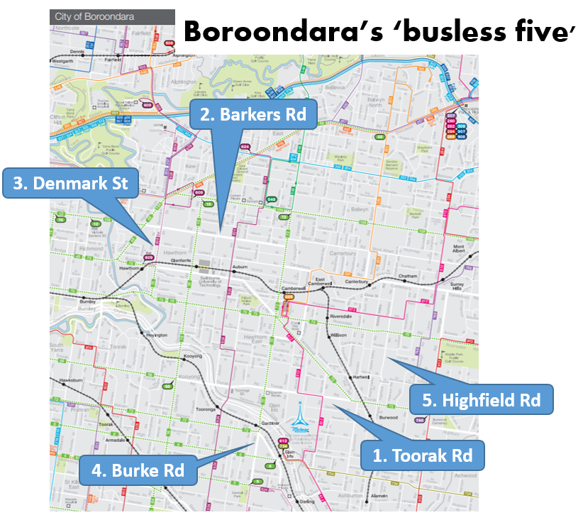
1. Toorak Rd
This is a key east-west road that has a tram along its western and eastern part but no bus in the middle. This is due to a network topology that sucks everything in towards Glenferrie/Camberwell. The historical lack of large destinations along parts of that corridor wouldn't have helped either.
The Glen Waverley train line in the area runs south-east while buses are north-south. This opens up a large gap where a simple east-west trip is not possible without substantial backtracking and changing. The lack of a bus also reduces connectivity to destinations such as Deakin University, the poorly served Coles headquarters and Stocklands Tooronga.
While a Toorak Rd bus route could make sense and connect many other routes in the area, a problem exists as to where it should terminate. This is unlike Canterbury Rd, which I discussed here, where the best termini are clearly Ringwood and Box Hill.
Possible western termini are either weak or they involve signifificant extra route kilometres. An example of a weak terminus is a station like Kooyong where there are few other major destinations nearby. Hence it is only useful for trips involving a change to a train. Similar can be said for the Route 58 tram terminus where it's a slow trip into town or a double transfer to a train at South Yarra.
Other options include a northward terminus at Swinburne University/Glenferrie or a southward terminus at Malvern Station. Both involve significant overlap with trams with the latter missing a Glen Waverley line station.
The cheapest eastern terminus could be near Burwood Station. That would provide connections to the 75 tram and the Alamein train (though that often involves a connection at Camberwell). Like on the western side there are few really major termination points that (i) would attract high passenger volumes or (ii) do overlap with other routes, notably Warrigal Rd.
A low cost possibility could be to form this route by extending the 766, which would provide a connection to Box Hill which should provide a strong terminus, especially if 766 was straightened (which it could be if reformed in conjunction with the construction of the new Surrey Hills Station). A further option could be merging with a Highfield Rd bus discussed later.
As for service levels it might justify being a good local route with some extra peak frequency if the route option chosen feeds a nearby station like Kooyong. But I can't see it being strong enough to be the sort of premium frequency and long hours routes that I'd recommend elsewhere.
2. Barkers Rd
This is an east-west street with no buses. It is half way between the parallel 109 tram and the Belgrave/Lilydale railway. Hence it has little unique coverage if you assume people will walk 800 metres to a high quality service. But there are several schools so there is potential for significant traffic at school times.
The most obvious route seems to be from Victoria Gardens to Camberwell. You might wish to run it further to Burnley Station via Burnley St but that is probably better part of its own north-south route. Hawthorn Station is another possibility but the geometry is poor for it to work as a serious train feeder.
As for its eastern terminus, there may be potential to extend it east to Box Hill via Mont Albert Rd which is also busless. However it would contribute no unique coverage as Mont Albert Rd, the 109 tram and the Ringwood train get increasingly close as you head east.
Unless there is substantial population densification in the area, I'm not sure that this route would have a particularly high patronage potential for anything but a local level of service. Introducing it would not be a high priority unless it could be shown as cost-effective in conjunction with reform of school buses in the area.
3. Denmark St/Power St
Strictly speaking it's not unbussed, but with only a couple of trips on the Route 609 operating, it might as well be. A much better service than that has a lot going for it. It would connect the busy Kew junction (served by numerous but slow trams) with the faster train at Hawthorn (just four stops into the city). And it would fill a connectivity gap.
Hawthorn has a good train service (better if upgraded to every 10 minutes already happens on weekends and is cheap to do on weekdays) but is a bit of weak terminus. You could argue that a short extension to Swinburne Uni at Glenferrie would make it stronger.
And in the north an extension via Chandler Hwy to say Fairfield could connect the Alphington development into rail. It could even be joined with the 567 to extend as far as Northland or even La Trobe University as discussed here.
This makes it a far cry from being a very short Denmark St route. However the expanded route possibly has more prospects than most other links discussed here. Therefore it might justify at least a Useful Network level of service.
4. Burke Rd
The part in Boroondara has a tram. But the part to the south has neither a tram nor bus. This represents a major break in the network with Caulfield only a few kilometres to the south. While traditionally not considered much of a destination for the eastern suburbs, it now has a Monash campus nearby. Also in its favour is the Metro tunnel and airport rail which will serve the station.
Personally I think there's enough density and likely need for both Tooronga and Burke Rd to have a bus. Ideally these should be fairly long north-south routes. But if you wanted to provide some non-duplicative service quickly you'd extend Route 734 to Caulfield via Gardiner and Burke Rd. This, and an upgrade for Tooronga Rd, is discussed here. They are likely more cost-effective network reforms than others discussed here. Longer term though a Caulfield - Camberwell tram would plug a major gap between the east and south-east including about half of Melbourne's railway lines.
5. Highfield Rd
When you zoom out you think it ought to have a bus. It's a long way from it to the parallel Alamein railway to the west and the parallel Warrigal Rd to the east. A short version of a Highfield Rd route might run from Burwood Station to the new Surrey Hills Station.
But neither of these are big attractions that would generate much all-day non commuter patronage. The Surrey Hills end might extend to Box Hill. It's less clear what you might do in the south. Potentially it could run via Summerhill Rd to Ashburton but that's not very strong either. Chadstone via Holmesglen is possibly the strongest alignment although Caulfield wouldn't be much further.
This would be one of the weaker routes presented today. Especially since there are some coverage overlaps with the 612 and 766. It would probably only ever be a less frequent neighbourhood style route. But it might be considered in conjunction with wider area bus network reforms.
Conclusion
What are your thoughts on the above bus concepts? Are there others I've missed? Or do you think they should be considered less important than other areas with populations known to have higher propensity to use buses. Comments are appreciated and can be left below.
See other Building Melbourne's Useful Network items here
5 comments:
There was quite an extensive network of local buses but, as discussed, few routes survived the 1950s with the onset of television and widespread car ownership. A Toorak to Hartwell bus service was reinstated about 1970 but failed after a short time.
1. Toorak Rd should be an extension of the route 58 to either Burwood or Deakin.
4. Same goes for Burke Rd. Delink Malvern Rd (EW) from Burke Rd (NS). Continue the Burke Rd tram to Caulfield, and Continue the Malvern Rd tram to Chadstone SC, taking the old rail trail from East Malvern to Dandenong Rd (in conjunction with extensions of the 5 to Darling and the 3/3a to East Malvern).
The other bus routes are great suggestions, more needs to be done to ensure at least 800m x 800m grid of busses are at high frequencies (talking every 10 to 15 minutes) and a coverage of 400m x 400m grid where possible at a frequency of at least every 20.
One possible route for a local bus to improve connections around the area could be a north-south route that also covers the Toorak Road gap. My proposal for this would be a route that starts at Kooyong then goes via Toorak Road to Gardiner station. Then it would continue along Burke road to Wattletree road to get to Carnegie and can finish at Moorabbin. This would make a useful north-south connection to currently difficult public transport journeys. The patronage wouldn't be high but time savings would make it extremely useful for local residents.
Great article. Thank you. Another and really easy fix is to put more buses on existing crowded routes, such as the bus which goes along Asquith Street, Kew, on the Eastern Freeway, to the city. At peak hour in the morning (pre-Covid) it often just left passengers at stops behind because it was so over-crowded. Not sure what it is looking like now.
There was once a bus which went along Highfield Road. I believe it left from Maling road, Canterbury, went along Canterbury road, turned in to Highfield Road and finished by Burwood railway station. The bus stops were still visible in the early '70s but when I asked about it I was told that it hadn't run for about 20 years.I wonder if one following this approximate route but terminating at Ashburton Library, Leisure Centre or Station might be viable?
Post a Comment