Apparently creating '20 minute neighbourhoods' is important. It's become a big part of planning rhetoric and documents. To quote: "Plan Melbourne is guided by the principle of 20-minute neighbourhoods". Others overseas see Melbourne as an early adopter of the concept, with us being second only to Portland, Oregon in embracing it, at least at planning level. It's also entered the federal political arena, with a mention by Labor Leader Anthony Albanese.
Not everywhere is talking 20 minutes. Paris is doing 15 minute cities while Sweden is going hyperlocal with 1 minute cities.
Back here in Melbourne, when COVID hit people were proclaiming the demise of CBD commuting and a revival of local living, including 20 minute neighbourhoods. But that might not necessarily happen. Or the results may be mixed. Here in Melbourne so far all we've seen is increased car traffic as restrictions lessened.
A lot of talk in serious planning circles seems to be wistful hopes along the lines of "If only people could be convinced to do ... then all would be right". Of course the people are not convinced and "all is not right".
It may instead be more helpful to start with the premise that "The customer is always right" and that "people will do what is most convenient for them". Responsiveness to the latter makes the urban environment and quality of available options a key influence.
This gets us back to Plan Melbourne. It talks the talk but does it walk the walk?

First we need to define what we're talking about. The '20 minute city' term has become fashionable in planning circles and definitions vary.
The one we use, stated here, is:
The 20-minute neighbourhood concept is all about ‘living locally’—giving people the ability to meet most of their daily needs within a 20-minute walk from home, with access to safe cycling and local transport options.
Feasability
What daily needs are we talking about? Except for a lucky minority I don't think it can include the type of work where people commute to jobs; Melbourne is too big for that. Although we might be able to think about better catering for people who work from home with opportunities possible if suburbs empty less during the day.
In relation to commuting, Canberra, a smaller city, aimed at some sort of containment with town centres and residential areas grouped around them but it too failed. If they had their choice departments opted for Barton or Civic over Woden, Tuggeranong or Belconnen. Or some ex-urban area out near the airport or in the bush like defence offices.
Canberra is full of careerist climbers. If people changed jobs they did not necessarily move house. Especially if households have multiple earners. This is exacerbated by the city's freeway-backed Y-plan that makes commutes long for a city of Canberra's population. Hence the ACT region functions as a metropolitan (and even cross-state) labour market with many long, mostly driving, commutes.
Back to Melbourne, our freeways we're enthusiastically extending are encouraging long-distance commuting. The CBD centrism of its public transport and the lack of off-peak express trains can make public transport a slower and less attractive option relative to driving even from suburbs near a station, especially for the increasing proportion of work commute trips outside traditional peak times.
What about schooling? Hardly anyone can walk to a TAFE or university unless they are in student housing. And due to lower numbers of children, a drift to private education and consolidated schools with more students, secondary schools are too far apart for active transport to work for most students. that is unless cycling is re-accepted as a transport mode for children (like it was 40-50 years ago). It won't be by risk-conscious parents unless there are dedicated and direct off-road cycling paths everywhere.
State primary schools are closer together. They are more tied to a geographic community. Indeed they have zoning polygons that are geographically based. Although they can have problems as the school most walkable from a house is not necessarily the one that is the crow-flies closest. And parents may choose to have their child privately educated or plead 'special needs' that exempts them from zoning.
Neighbourhood churches are fewer. The minister no longer necessarily lives in the house next door. Local Christian congregations are ageing and thinning. The most enthusiastic evangelical or ethnically based are often in industrial or green wedge area megachurches far beyond walking or even bus access.
The same could be said for sporting teams and service clubs. Their catchments are more often driveable than walkable and associations may be maintained even if people move away. Even the names of the AFL teams reflect the Melbourne of the late 1800s rather than where they or their supporters are now based. Specialisation can often trump localism for the type of structured childrens' extra-curricular activities favoured by, paid for and ferried to by middle-class parents.
Public libraries? They're common in established inner and middle suburbs. But they're exceedingly rare in some outer areas. The City of Melton is pretty much a library desert with just two serving a 173 000 population. So only rarely are they walkable to. This is despite it having new housing estates that are surprisingly dense. Claims that higher housing density necessarily leads to better transport and walkable services are theoretical figments; if you really want those then someone has to decide to provide or build them.

Local retail is another possibility. Corner stores are fewer due to longer opening hours of major supermarkets and the irrelevance of much of what they sold. For example people either buy less of or have stopped buying corner store mainstays such as newspapers, cigarettes, Metcards or mobile phone recharges. But liquor stores are as numerous as ever, with drink-driving laws probably providing an encouragement to walk (or stagger) rather than drive.
The trend is for supermarkets to get bigger and be more widely spaced so that fewer people can walk to one. De-regulated zoning has placed supermarkets in industrial areas with no or limited walk-up catchments. Supermarkets may over-build in an attempt to lock away sites from or squeeze out rivals (which eventually shut down). The 'Costco effect' is basically a giant game of monopoly that provides superficially attractive prices but shifts costs onto the customer with longer driving and less localism.
Retail trends have seen liquor stores (typically occupying the premises of a former supermarket) to be the last hold-outs in shopping strips that have lost their baker, butcher and fruiterer. Other survivors might be a hairdressers and a takeaway, insufficient in themselves to provide a full range of local services. Cafes might appear in gentrifying neighbourhoods, but their gourmet fare is too dear for daily consumption except by the well-off (who have in recent times taken up working from home).
These, plus still rising car ownership, the catering to it through mandated minimum parking requirements in suburbs and reduced permeability for walkers in the suburbs (eg freeways, main roads, roundabouts, creeks without bridges and even crossingless railways) have made the laudable aims of the 20 minute city opposed to almost everything that's happened in the last 60 years. Painting a mural or putting some flowers in the middle of a roundabout won't change any of that.
Despite all the obstacles that make merely holding on to what we have difficult, Plan Melbourne has '20 minute cities' as a guiding principle. Hence for Plan Melbourne to succeed then so will the '20 minute city' policy. Consequently it is reasonable to scrutinise carefully any locations and projects associated with same.
Pilot project sites
There are three 20 minute neighbourhood pilot projects. They are located at:
* Sunshine West
* Strathmore
* Croydon South
All three are small local shopping strips in postwar middle to outer suburbia. Sunshine West and Strathmore have kindergartens and primary schools nearby. None has a substantial supermarket, public library or recreation centre.
While these precincts provide some food, retail and other services, they are too small to furnish reasonable daily needs. If you want the concept to work then they might have been better off picking middle-sized centres like Niddrie, Glenroy, Reservoir, Mentone, Mitcham, etc. These service more needs, have better transport and may support higher residential densities.

Public transport at pilot project sites
What is public transport like at each of the three centres? All centres have it but typically in only two or three directions. By centre, Sunshine West is on a major east-west bus route, Strathmore has a train and a limited service bus route to the east while Croydon South as a north-south bus route.
In more detail:
Sunshine West has Route 420 bus running east-west to major centres outside the area including Sunshine, Deer Park and Watergarden. Route 471 close by provides access to the south. A limited road network restricts access to the north including to the Sunshine Hospital area. Route 420's 7 day 20 minute service is better than average for buses in Melbourne. Although it's a trunk route with a favourable catchment its operating hours meet minimum standards for local routes with no late evening service.

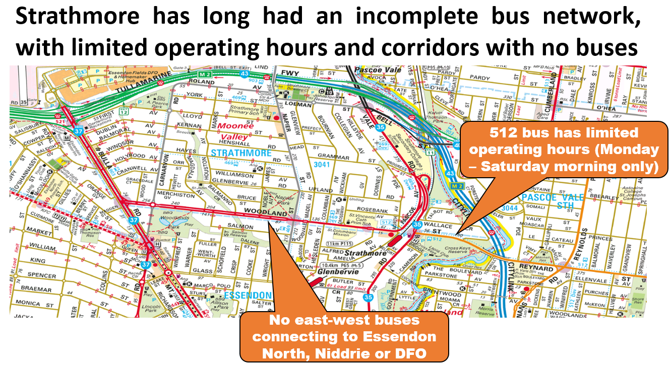

Overall these areas have what you might call a basic to medium level of public transport access. None are the types of precincts that you'd want to encourage high density and car-free living without a commensurate improvement in transit service. This is unlike some of the rail-based centres mentioned above that it would have better prospects, especially with some bus network reform.
20 minute neighbourhood initiatives
What sort of improvements are included in the pilot projects?
They are basically small scale walking and cycling improvements and local beautification. Some of them are what they term 'temporary activations' introduced to assist COVID-19 recovery. Examples include local traffic calming, parklets, plantings, building beautifications and walking improvements.
You can read more detailed reports on them here for each location.
Are they significant?
20 minute neighbourhood initiatives are essentially minor capital works. I don't dispute their value. Indeed many should be routine work at neighbourhood centres across Melbourne.
But are they the sort of stuff that can be relied on to produce the big changes that metropolitan-wide plans talk about? Especially when much larger forces is pulling things the other way? I hardly think so.

As much as I think that those behind '20 minute neighbourhoods' are well meaning, and individual parts are good, I cannot bring myself to take the pilot projects seriously. Even if, like Croydon's, they got a planning design award.
When considered against the bigger picture and the forces at play they are merely three sneezes in a windstorm. We all feel better after a sneeze but let us not kid ourselves it will cure our ails.
On the other hand if the 20 minute neighbourhood program comprised building local facilities like new libraries, transit network and service upgrades (as per Stanley and Hansen and the Useful Network here), additional station entrances, accessible stops, large scale roundabout removals and new cycle paths then I'd take notice. Especially if accompanied by supportive metropolitan-wide policies like the abolition of minimum parking requirements, rewritten intersection design rules, road space reallocation, walking friendly traffic light cycle reprogramming, lower speed limits, tax law, road charging, revised personal ID rules that prohibit reliance on driving licences, and a rethink in how we plan and approve retail, education and transport projects.
That's obviously a bigger agenda. But it's needed if Plan Melbourne and its 20 minute neighbourhoods are ever to earn the credibility that it needs to succeed.
1 comment:
It might be worth noting that in theory, 20 minute cities have bipartisan support in Victoria - the concept was introduced by Matthew Guy when he was planning minister - though no doubt the fine detail has changed over time. https://www.theage.com.au/national/victoria/plans-to-make-melbourne-a-20-minute-city-20121026-289ll.html
Post a Comment