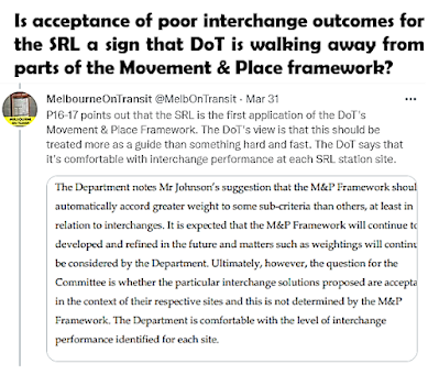
As I noted here, one of the good things about the currently happening Suburban Rail Loop Inquiry and Public Hearing process is the analysis and documents it brings into the public domain. This includes a lot of internally prepared material that outsiders wouldn't know about or even have access to.
See this big long Twitter thread for summaries of examples.
Two tabled documents that caught my eye due to their applicability across all of transport (not just the SRL) is the Victorian Department of Transport's Movement and Place Framework.
Tabled document number 379 is the Framework while 380 is the technical appendix. Today I'll run through them both and explain why they are important for people involved in transport planning and advocacy.
Movement and Place Framework
On its website the Department of Transport describes Movement & Place as a way of thinking about the roles and challenges for our transport system now and into the future. It is a decision-making framework that outlines competing interests and reports performance in terms of movement, place, environment and safety outcomes.
It encourages a view that roads and streets are not always just a way to get from A to B. Instead many have other roles including being parts of great places and precincts. This thinking involves weighing up the relative scale and importance of these activities and using this knowledge to drive planning priorities.
The DoT and Vicroads have organised Movement and Place training courses for transport professionals. DoT also publish the 40 page Movement and Place in Victoria introduction here. This is Document 379 as tabled at the SRL hearing. It introduces the reader to the four modules of the Movement and Place framework (network classification, network performance, options development, options assessment).
It evolved out of old hierarchical road classification models based on traffic handling capacity. This progressed to SmartRoads (including different transport modes) and then to Movement and Place (which, as the name suggests, adds place to form a two dimensional classification system. Similar concepts used overseas include 'Link and Place' in the UK and 'Complete Streets' in North America.
Use of Movement and Place is intended to be within the context of broader principles, as set out below.
Module 1 is about classification. This is on a scale of significance, from local to state significant. Assessment is based on both movement and place scales with a grid style matrix to compare sites, something like below. (click for a better view)
This is perhaps of even greater interest as DoT does not publish it on its website. It has only come out because it was tabled through the SRL hearing process. If you want to see it, go to the SRL Inquiry and Advisory Committee page, go to 'Tabled Documents' and select the various dates until you get to document number 380 (it's under 12-18 March). Then download and SAVE.
Don't let the term 'Technical Appendix' scare you; large parts are understandable to the layperson. Importantly it has specific and measurable assessment standards. This lets you gauge whether something is good or not (or, in their jargon, has an appropriate 'level of service' or not). And it helps communities call out instances of bad design and hold agencies such as the DoT and projects such as the SRL accountable against professionally-developed standards.
The Appendix contains tangible classifications for the importance and performance 'modules' described above.
Module 1's classifications are about importance. Both movement and place are on axes from locally significant to state significant. The volume is also important for movement, ranging from local movement to mass movement. This is split up by mode such as walking, cycling, freight, general traffic, public transport and public transport interchange. The latter includes everything from a quiet regional coach stop to a major railway station serving almost the whole state.
Module 2's classifications are to do with performance. Performance is on an A-E scale (A being the best). Below is an example for walking. Highest level of service coincide with minimal delay while lowest level of service coincides with longer delays.
In a refreshing burst of frankness, network performance is acknowledged to be 'very poor' for walking. While not stated this is largely due to a combination of road traffic volumes and design choices like wide roads with long turning radii, large roundabouts, long signal cycle times, unresponsive crossings and too few zebra crossings. The good news is that these can be changed. And often cheaply too!
As well as crossing time there is distance. Especially if people who want to go straight across to their destination are forced to backtrack due to road design or crossing placement. This is recognised below where both delay and distance are considered.
DoT's Movement and Place framework is an interesting way of thinking about transport priorities and trade-offs. It is really brought to life by the Technical Appendix that has only recently become publicly available, and only then due to a public hearing process. While its traffic planning origin means that it misses certain public transport essentials like service frequency, it is still very useful for assessing things like walkability and interchange design and performance.
Its impact depends on whether it is recognised and used in the planning of projects, large and small. There's lots of good stuff in it. It needs to be taken seriously and not dispensed with by its sponsoring department as soon as there's the tiniest bit of push-back from a corner-cutting project agency.
On this the SRL hearings and whether the built design is modified to address the issues such as interchange connectivity will be an interesting test case of the Movement and Place framework's status and resilience. If they aren't going to properly use it in their biggest, best funded and most important rail project then where would it apply?
Comments on Movement and Place are appreciated and can be left below.


No comments:
Post a Comment